TOWN OF MANCHESTERplanning1.townofmanchester.org/NewPlanning/assets/File/minutes... · TOWN OF...
31
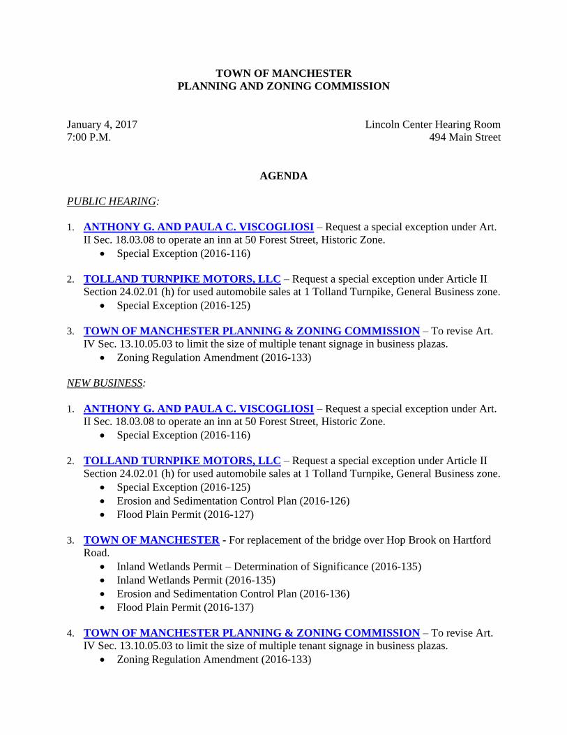
TOWN OF MANCHESTER PLANNING AND ZONING COMMISSION January 4, 2017 Lincoln Center Hearing Room 7:00 P.M. 494 Main Street AGENDA PUBLIC HEARING: 1. ANTHONY G. AND PAULA C. VISCOGLIOSI – Request a special exception under Art. II Sec. 18.03.08 to operate an inn at 50 Forest Street, Historic Zone. Special Exception (2016-116) 2. TOLLAND TURNPIKE MOTORS, LLC – Request a special exception under Article II Section 24.02.01 (h) for used automobile sales at 1 Tolland Turnpike, General Business zone. Special Exception (2016-125) 3. TOWN OF MANCHESTER PLANNING & ZONING COMMISSION – To revise Art. IV Sec. 13.10.05.03 to limit the size of multiple tenant signage in business plazas. Zoning Regulation Amendment (2016-133) NEW BUSINESS: 1. ANTHONY G. AND PAULA C. VISCOGLIOSI – Request a special exception under Art. II Sec. 18.03.08 to operate an inn at 50 Forest Street, Historic Zone. Special Exception (2016-116) 2. TOLLAND TURNPIKE MOTORS, LLC – Request a special exception under Article II Section 24.02.01 (h) for used automobile sales at 1 Tolland Turnpike, General Business zone. Special Exception (2016-125) Erosion and Sedimentation Control Plan (2016-126) Flood Plain Permit (2016-127) 3. TOWN OF MANCHESTER - For replacement of the bridge over Hop Brook on Hartford Road. Inland Wetlands Permit – Determination of Significance (2016-135) Inland Wetlands Permit (2016-135) Erosion and Sedimentation Control Plan (2016-136) Flood Plain Permit (2016-137) 4. TOWN OF MANCHESTER PLANNING & ZONING COMMISSION – To revise Art. IV Sec. 13.10.05.03 to limit the size of multiple tenant signage in business plazas. Zoning Regulation Amendment (2016-133)
Transcript of TOWN OF MANCHESTERplanning1.townofmanchester.org/NewPlanning/assets/File/minutes... · TOWN OF...
TOWN OF MANCHESTER
PLANNING AND ZONING COMMISSION
January 4, 2017 Lincoln Center Hearing Room
7:00 P.M. 494 Main Street
AGENDA
PUBLIC HEARING:
1. ANTHONY G. AND PAULA C. VISCOGLIOSI – Request a special exception under Art.
II Sec. 18.03.08 to operate an inn at 50 Forest Street, Historic Zone.
Special Exception (2016-116)
2. TOLLAND TURNPIKE MOTORS, LLC – Request a special exception under Article II
Section 24.02.01 (h) for used automobile sales at 1 Tolland Turnpike, General Business zone.
Special Exception (2016-125)
3. TOWN OF MANCHESTER PLANNING & ZONING COMMISSION – To revise Art.
IV Sec. 13.10.05.03 to limit the size of multiple tenant signage in business plazas.
Zoning Regulation Amendment (2016-133)
NEW BUSINESS:
1. ANTHONY G. AND PAULA C. VISCOGLIOSI – Request a special exception under Art.
II Sec. 18.03.08 to operate an inn at 50 Forest Street, Historic Zone.
Special Exception (2016-116)
2. TOLLAND TURNPIKE MOTORS, LLC – Request a special exception under Article II
Section 24.02.01 (h) for used automobile sales at 1 Tolland Turnpike, General Business zone.
Special Exception (2016-125)
Erosion and Sedimentation Control Plan (2016-126)
Flood Plain Permit (2016-127)
3. TOWN OF MANCHESTER - For replacement of the bridge over Hop Brook on Hartford
Road.
Inland Wetlands Permit – Determination of Significance (2016-135)
Inland Wetlands Permit (2016-135)
Erosion and Sedimentation Control Plan (2016-136)
Flood Plain Permit (2016-137)
4. TOWN OF MANCHESTER PLANNING & ZONING COMMISSION – To revise Art.
IV Sec. 13.10.05.03 to limit the size of multiple tenant signage in business plazas.
Zoning Regulation Amendment (2016-133)

5. ELECTION OF OFFICERS
6. ADMINISTRATIVE REPORTS
7. RECEIPT OF NEW APPLICATIONS
R:\Planning\PZC\2017\01 - January 4\Agenda 04 JAN 2017.docx
TOWN OF MANCHESTER
LEGAL NOTICE
The Planning and Zoning Commission will hold a public hearing on January 4, 2017, at 7:00
P.M. in the Lincoln Center Hearing Room, 494 Main Street, Manchester, Connecticut to hear
and consider the following petitions:
ANTHONY G. AND PAULA C. VISCOGLIOSI – Special Exception (2016-116) – Request a
special exception under Art. II Sec. 18.03.08 to operate an inn at 50 Forest Street, Historic Zone.
TOLLAND TURNPIKE MOTORS, LLC – Special Exception (2016-125) – Request a special
exception under Article II Section 24.02.01 (h) for used automobile sales at 1 Tolland Turnpike,
General Business zone.
TOWN OF MANCHESTER PLANNING & ZONING COMMISSION – Zoning Regulation
Amendment (2016-133) – To revise Art. IV Sec. 13.10.05.03 to limit the size of multiple tenant
signage in business plazas.
At this hearing interested persons may be heard and written communications received. A copy
of the proposed zoning regulation amendment may be reviewed in the Town Clerk’s office, 41
Center Street, during regular business hours, 8:30 a.m. – 5:00 p.m., Monday through Friday, or
in the Planning Department, 494 Main Street, during regular business hours, 8:30 – 4:30,
Monday through Friday.
Planning and Zoning Commission
Eric Prause, Chair
TOWN OF MANCHESTER
PLANNING DEPARTMENT
TO: Planning and Zoning Commission
FROM: Renata Bertotti, Senior Planner
DATE: December 27, 2016
RE: Anthony G. and Paula C. Viscogliosi – 50 Forest Street
Special Exception for an Inn in the Historic Zone (2016-116)
The applicants, Mr. and Mrs. Viscogliosi, are seeking a special exception under Art. II Sec.
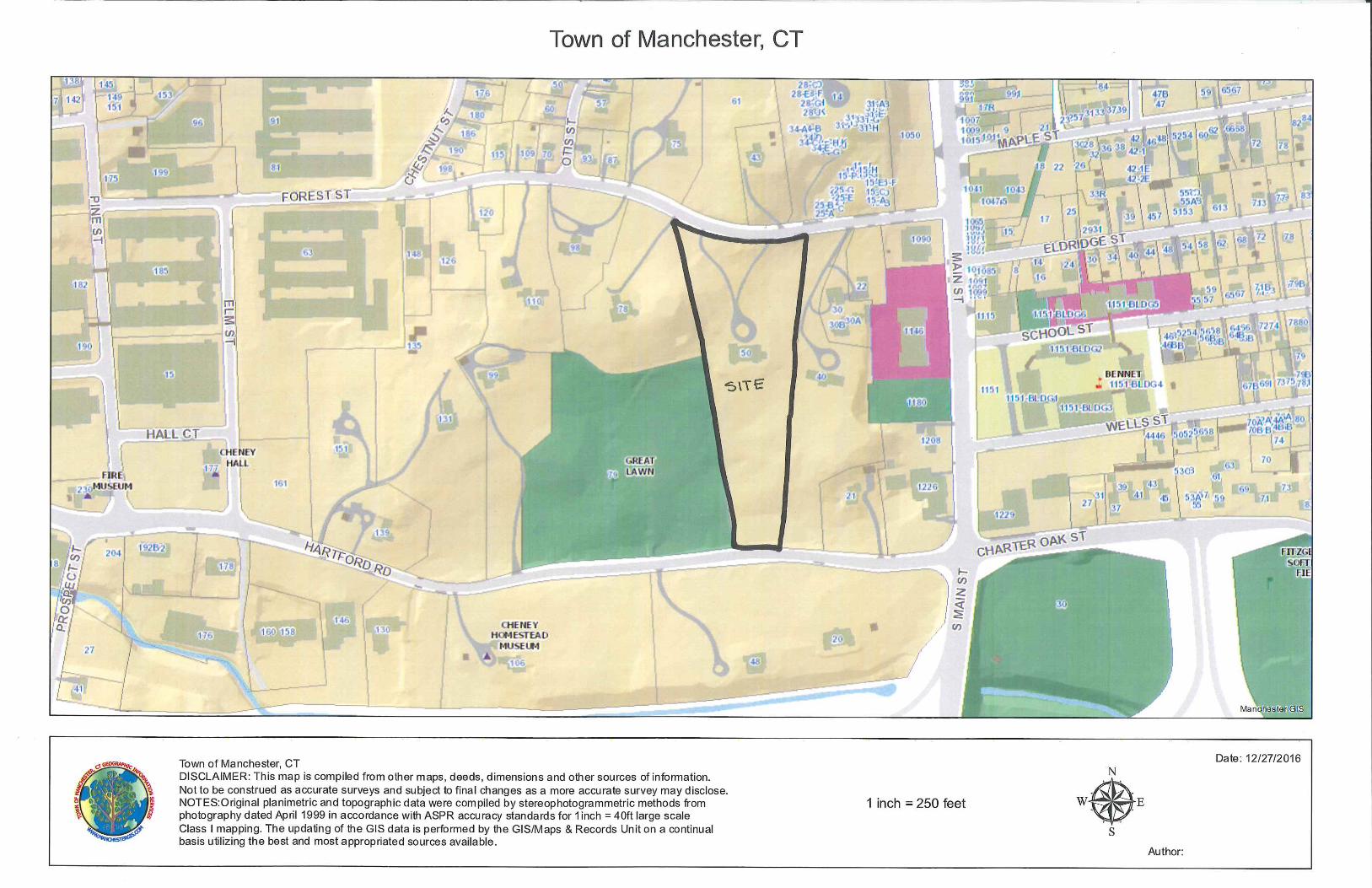
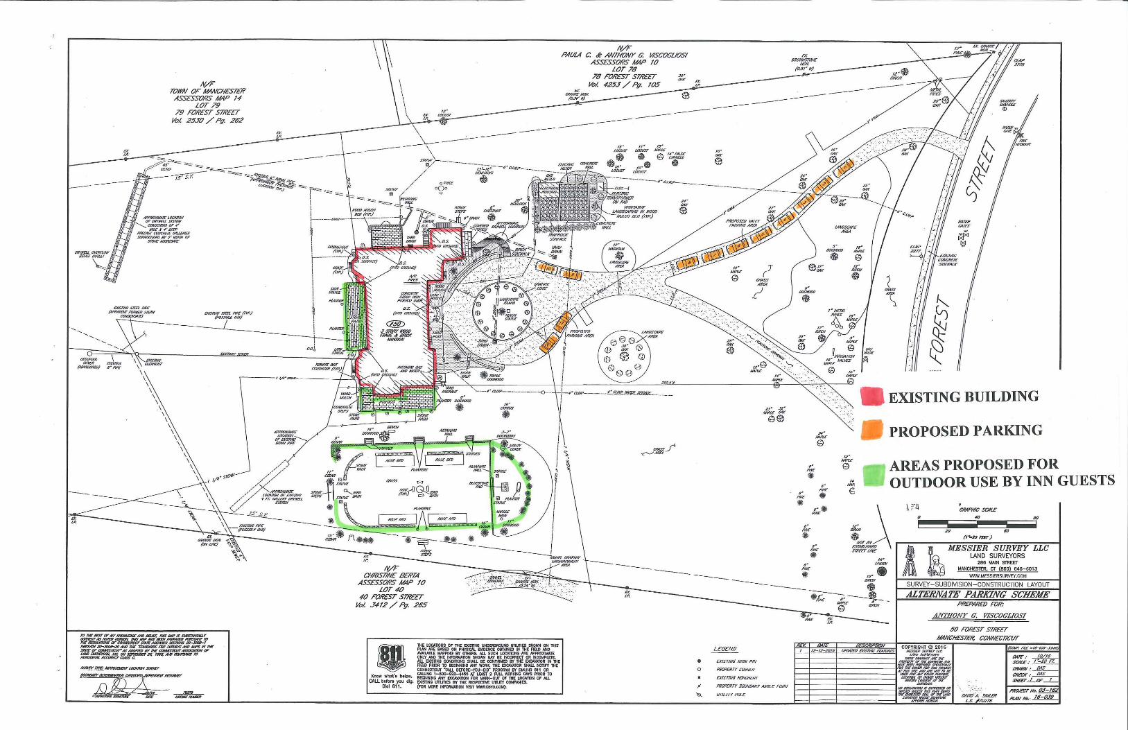
18.03.08 to operate an inn at their property at 50 Forest Street. 50 Forest Street is a 5.56-acre
site located on the south side of Forest Street. The property also fronts Hartford Road and abuts
the Great Lawn (see the attached location map). A +/- 13,700 sq. ft. historic Cheney Mansion is
located on the site.
According to a narrative submitted to the Planning Department on December 15, 2016
(attached), the inn will provide overnight boarding and breakfast service to professionals such as
doctors, lawyers and business executives conducting mini-conferences or retreats on the
property, and to families for family gatherings. At this time, the applicants do not propose any
conferences or gatherings offered to patrons that are not overnight guests at the inn. The
narrative states that there will not be any assemblies of more than 16 persons at any given time.
According to the narrative, Mr. and Mrs. Viscogliosi intend to live in the residence on a part-
time basis. The inn will be managed by their employee who will stay in the inn overnight on the
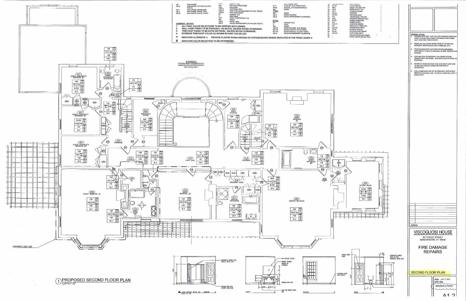
nights the owners are not there. The employee will stay in one of the seven bedrooms on the
second floor of the mansion.
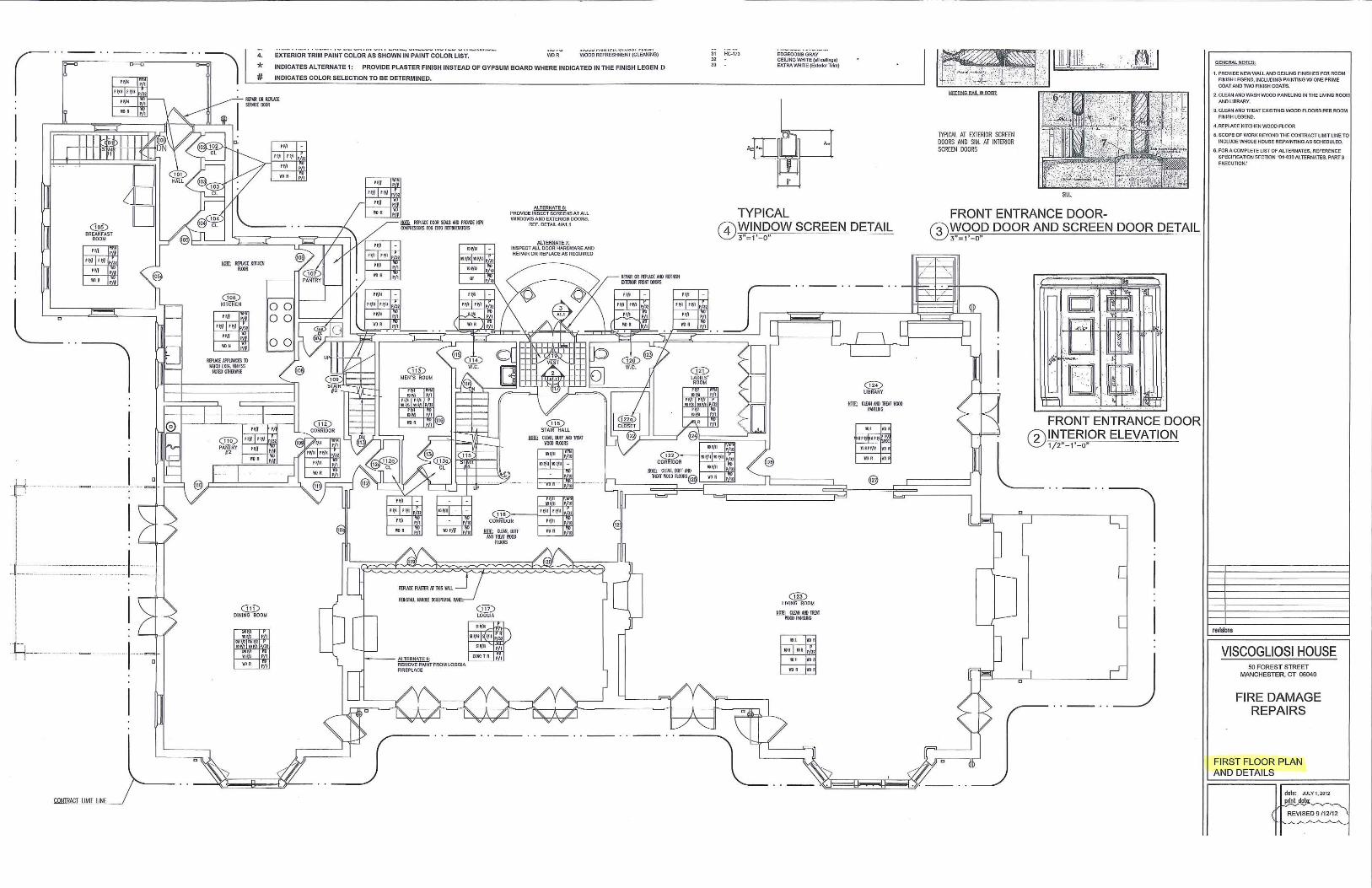
No changes to the exterior of the building are proposed at this time. The applicants propose to
make six rooms on the second floor of the existing 13,697 sq. ft. historic Cheney Mansion
available for sleeping accommodations to overnight guests at the inn. According to the narrative
submitted with the application, breakfast service may be provided, and if that is the case, it
would be served in the breakfast area on the first floor of the mansion. Four additional rooms on
the first floor, the Den/Library, the Living Room, the Garden Room and the Dining Room, will
be available to the patrons of the inn for meetings and quiet enjoyment. Two patios and the
garden will also be available to the guests of the inn.
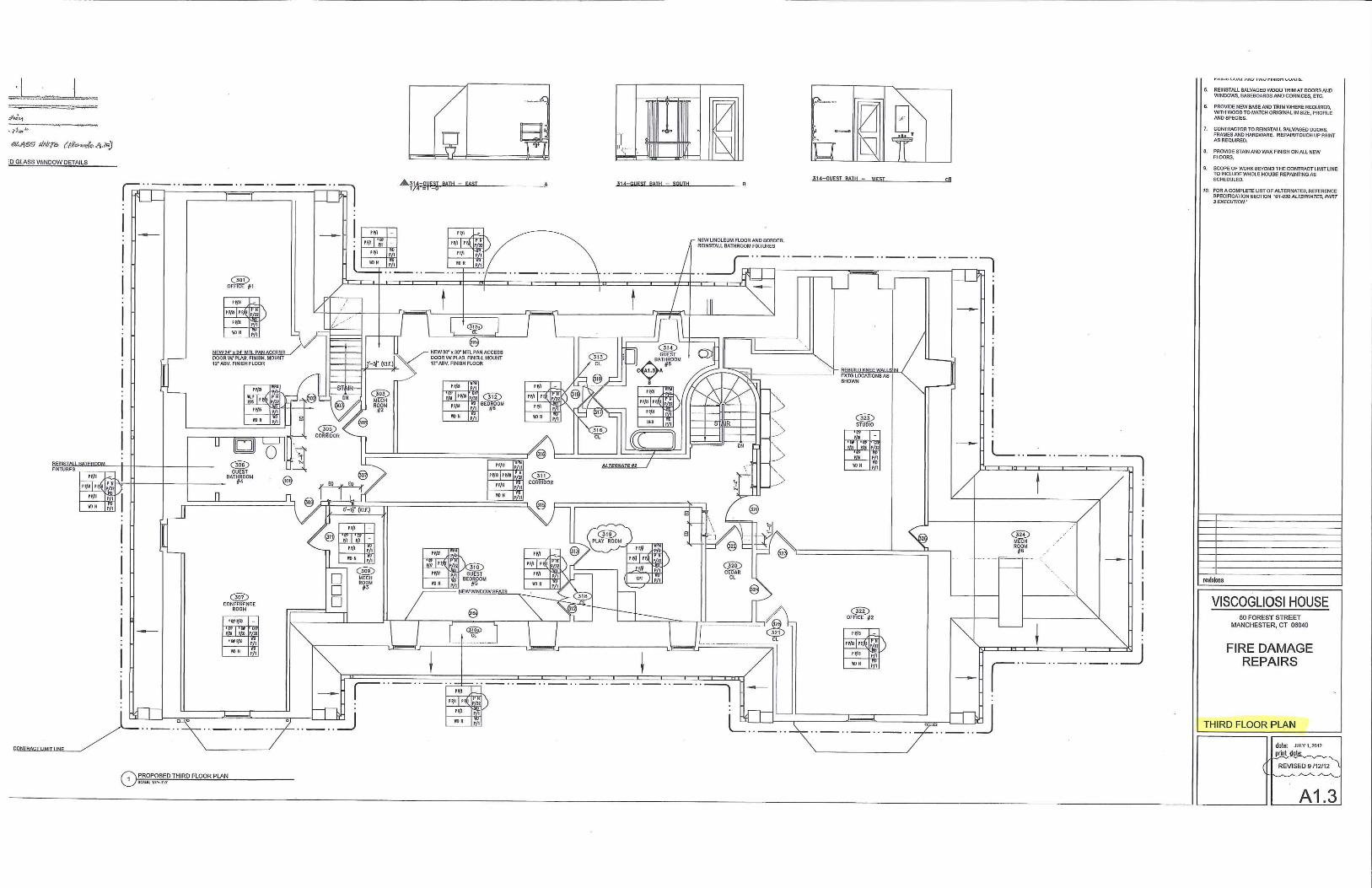
The third floor of the mansion is proposed to be closed off and restricted to the private use of the
property owners only (floor plans are attached for your review).
– 2 –
The applicants plan on using the existing driveways for valet parking for up to 12 cars. See the
attached site plan for the proposed parking plan. The applicants state that this would provide
sufficient parking for overnight guests, the employee, and the property owners. The narrative
further states that: “If other people are invited to use the property, additional parking is available
nearby within walking distance on Main Street.”
In addition to the above described uses, the owners also plan to occasionally use their home for
philanthropic events. As described in the attached narrative, on those dates the inn will not have
overnight occupants.
This application received a favorable recommendation from the Cheney Brothers National
Historic District Commission at their December 1, 2016 meeting.
The staff is currently reviewing the revised application narrative and site plans. We will submit
our report to you at the meeting.
Attachments
R:\Planning\PZC\2017\01 - January 4\Packet Memos\2016-116 Viscogliosi.docx
TOWN OF MANCHESTER
PLANNING DEPARTMENT
TO: Planning and Zoning Commission
FROM: Renata Bertotti, Senior Planner
DATE: December 28, 2016
RE: Tolland Turnpike Motors, LLC – 1 Tolland Turnpike
Special Exception (2016-125)
Erosion and Sedimentation Control Plan (2016-126)
Flood Plan Permit (2016-127)
Introduction
The applicant, Tolland Turnpike Motors, LLC, is seeking a special exception under Article II
Section 24.02.01 (h) to allow the sale of used automobiles at 1 Tolland Turnpike, General
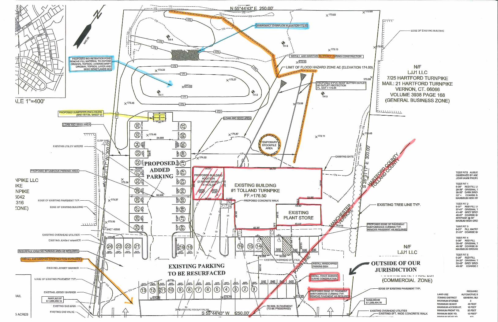
Business zone. The 1.71-acre site is located on the north side of Tolland Turnpike and crosses
the town boundary with Vernon.
The applicant is proposing to remove pavement, install bituminous curbing and install a
temporary fence barrier in Vernon. The Manchester Planning and Zoning Commission has no
jurisdiction on this portion of the site so the applicant has been advised that for any proposed
work there they would have to seek approvals from the Town of Vernon.
The applicant was further advised that they may be required to obtain a Certificate of Location
approval under Section 14-54 of the Connecticut General Statutes in order to secure a used car
dealer license from the CT Department of Motor Vehicles which per the latest change to the
Connecticut General Statutes, must be sought from the Zoning Board of Appeals.
A Flood Plain Permit and the certification of the Erosion and Sedimentation Control Plan are
also requested.
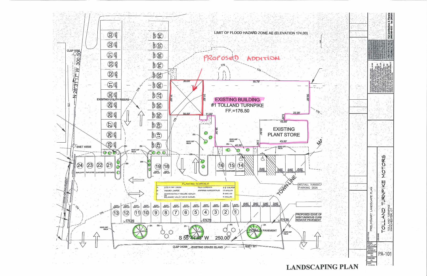
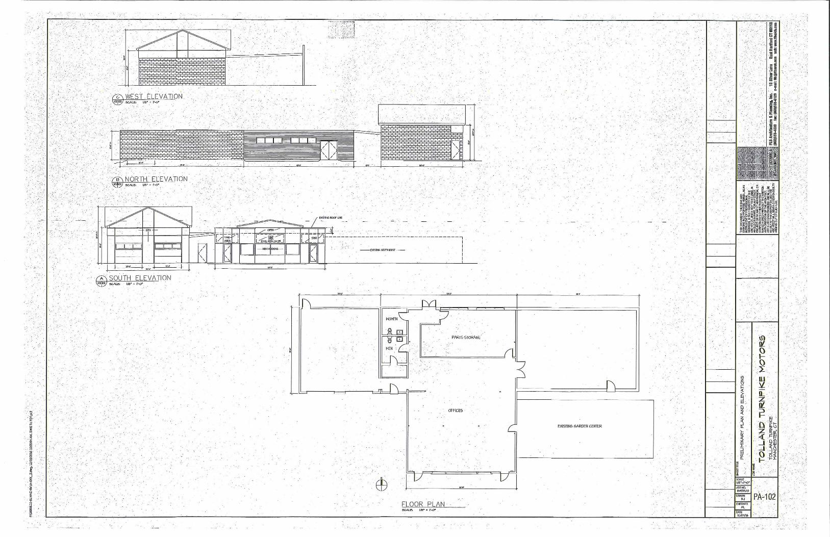
There is an existing +/- 5, 000 sq.ft. building on the site, approximately 1, 000 sq.ft. of which is
currently occupied by a retail plant store which will continue to operate. The remaining +/- 4,000
sq.ft. of the existing building is currently vacant. The applicant would like to use the vacant
portion of the existing building and erect a 30’x 32’ building addition on the west side of the
existing building for the auto sales and repair business.
Project Description
The auto sales and repair business is proposed to operate from 9 AM to 6 PM Monday thru
Saturday. According to the Traffic Impact Statement, the business will have a total of 4
December 28, 2016
Page 2
- 2 -
employees. The business will primarily sell vehicles, and provide service and repairs to only
those vehicles that are sold on site.
The site will be accessed via two existing curb cuts on Tolland Street. According to the Traffic
Impact Statement dated December 15, 2016 prepared by the applicant’s civil engineer, Andrew
Bushnell of Bushnell Associates, LLC the anticipated peak hour trip volume for the facility is 10
vehicle trips per hour. The street and near-by intersections are capable of handling this volume
and the crash data reviewed by the site engineer “does not indicate any pattern of repeated
automobile accidents in the area of the site.”
A total of 50 parking spaces (see the attached plan) will be dedicated to the auto sales and repair
business; eight additional spaces remain on the site to be used by the plant retail business. The
applicant proposes to use 39 spaces for auto sales, 2 for outside repair storage, 2 for indoor repair
storage, 3 for customers and 4 for employees. A dumpster enclosure is proposed at the north end
of the proposed parking area.
The applicant is proposing to resurface the existing parking area on the site (parking spaces 1
thru 24) and to build additional 24-space parking area (parking spaces 25 thru 48). The proposed
development will add approximately 9,400 sq.ft. of impervious surface which will result in an
increase in the peak stormwater flow.
In order to bring the peak stormwater flow to equal or less than existing levels, which is required
by our regulations, the applicant proposes construct a bio-retention basin. According to the
Stormwater Management Report, the proposed bio-retention basin has been designed to also
provide stormwater pollutant treatment by creating a wetland area in the pond bottom. The
banks of the bio-retention basin are proposed to be planted with the New England Erosion
Control/Reclamation Mix for detention basins and moist sites and a wetlands seed mix is
proposed to reestablish the bottom as a wetland area. The applicant’s soil scientist, John P. Ianni,
in his October 14, 2016 letter to applicant’s design engineer recommends that the planting of the
bio-retention pond be monitored for two growing seasons, and if sufficient plant growth is not
realized within that period, supplemental plant materials be added.
The attached Landscaping Plan shows three proposed Linden trees along the southern property
boundary, and several junipers and azalea shrubs.
The proposed changes to the building consist of erection of a 30’x 32’ addition on the west side
of the existing building. The proposed addition features two garage bay doors facing Tolland
Turnpike, and brick on the west and north. Attached for your review are proposed building
elevations and the floor plan. We have advised the applicant to provide a colored material board
for the Commission’s review at the meeting.
December 28, 2016
Page 3
- 3 -
Considerations for the Commission
Special Exception
When making a decision on this application, the Commission should consider the general special
exception criteria of Article IV Section 20 and the specific special exception criteria for
automobile sales, repair and service listed in Article IV Section 5 of the Manchester Zoning
Regulations. The special exception criteria of Article IV Section 20 are listed below:
(a) Suitable Location for Use
(b) Suitable Structures for Use
(c) Neighborhood Compatibility
(d) Adequate Parking and Access
(e) Adequate Streets for Use
(f) Adequate Emergency Access
(g) Adequate Public Utilities
(h) Environmental Protection and Conservation
(i) Consistent with Purposes- That the proposed use will not have any detrimental effects
upon the public health, safety, welfare or property values and the proposed use will not
conflict with the purposes of the Regulations.
In addition, under Article IV Section 5:
“The Planning and Zoning Commission shall not give approval unless it finds that the location is
suitable for the use intended, due consideration being given to the proximity of schools, places of
worship, libraries, theaters or playhouses or other places of public gatherings, intersecting streets,
traffic conditions, width of highway and effect of public travel and that such use will not imperil
the safety of the public.”
Erosion and Sedimentation Control Plan (2016-126)
The applicant has proposed measures to control erosion and sedimentation during construction.
The proposed measures are highlighted on the attached plan.

December 28, 2016
Page 4
- 4 -
At the construction entrance, the applicant proposes a temporary anti-tracking pad. A temporary
topsoil stockpile, protected by a row of silt fence, is also shown on the plan. The Stormwater
Management Report indicates that the proposed bio-retention basin will be excavated before
other construction activities begin on the site and act as a temporary sediment basin during the
construction. Silt fence is proposed downgradient from the proposed bio-retention basin.
The anticipated construction period is expected to be completed two months after the beginning
of site work.
Flood Plain Permit (2016-127)
A portion of the site is located in the regulated 100-year flood plain associated with the
Hockanum River. Revised plans for the proposed application were still under review at the time
this memo was drafted. A report will be provided regarding the status of the review of flood
plain permit requirements at the meeting.
Staff Review
Town staff reviewed the plans and documents submitted with this application, and provided
comments to the applicant. We are currently reviewing the revised the plans and documents and
will report our comments to you at the meeting.
RB
Attachments
R:\Planning\PZC\2017\01 - January 4\Packet Memos\2016-125, 126, 127 Tolland Turnpike Motors.doc
TOWN OF MANCHESTER
PLANNING DEPARTMENT
TO: Planning & Zoning Commission
FROM: Renata Bertotti, Senior Planner
DATE: December 27, 2016
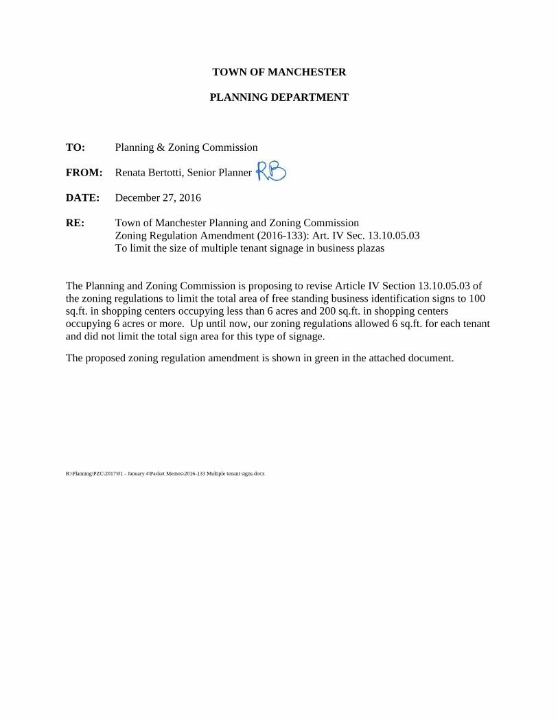
RE: Town of Manchester Planning and Zoning Commission
Zoning Regulation Amendment (2016-133): Art. IV Sec. 13.10.05.03
To limit the size of multiple tenant signage in business plazas
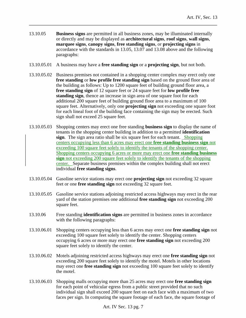
The Planning and Zoning Commission is proposing to revise Article IV Section 13.10.05.03 of
the zoning regulations to limit the total area of free standing business identification signs to 100
sq.ft. in shopping centers occupying less than 6 acres and 200 sq.ft. in shopping centers
occupying 6 acres or more. Up until now, our zoning regulations allowed 6 sq.ft. for each tenant
and did not limit the total sign area for this type of signage.
The proposed zoning regulation amendment is shown in green in the attached document.
R:\Planning\PZC\2017\01 - January 4\Packet Memos\2016-133 Multiple tenant signs.docx
Art. IV, Sec. 13
Art. IV Sec. 13 pg. 7
13.10.05 Business signs are permitted in all business zones, may be illuminated internally or directly and may be displayed as architectural signs, roof signs, wall signs, marquee signs, canopy signs, free standing signs, or projecting signs in accordance with the standards in 13.05, 13.07 and 13.08 above and the following paragraphs:
13.10.05.01 A business may have a free standing sign or a projecting sign, but not both.
13.10.05.02 Business premises not contained in a shopping center complex may erect only one free standing or low profile free standing sign based on the ground floor area of the building as follows: Up to 1200 square feet of building ground floor area, a free standing sign of 12 square feet or 24 square feet for low profile free standing sign, thence an increase in sign area of one square foot for each additional 200 square feet of building ground floor area to a maximum of 100 square feet. Alternatively, only one projecting sign not exceeding one square foot for each lineal foot of the building face containing the sign may be erected. Such sign shall not exceed 25 square feet.
13.10.05.03 Shopping centers may erect one free standing business sign to display the name of tenants in the shopping center building in addition to a permitted identification sign. The sign area ratio shall be six square feet for each tenant. Shopping centers occupying less than 6 acres may erect one free standing business sign not exceeding 100 square feet solely to identify the tenants of the shopping center. Shopping centers occupying 6 acres or more may erect one free standing business sign not exceeding 200 square feet solely to identify the tenants of the shopping center. Separate business premises within the complex building shall not erect individual free standing signs.
13.10.05.04 Gasoline service stations may erect one projecting sign not exceeding 32 square feet or one free standing sign not exceeding 32 square feet.
13.10.05.05 Gasoline service stations adjoining restricted access highways may erect in the rear yard of the station premises one additional free standing sign not exceeding 200 square feet.
13.10.06 Free standing identification signs are permitted in business zones in accordance with the following paragraphs:
13.10.06.01 Shopping centers occupying less than 6 acres may erect one free standing sign not exceeding 100 square feet solely to identify the center. Shopping centers occupying 6 acres or more may erect one free standing sign not exceeding 200 square feet solely to identify the center.
13.10.06.02 Motels adjoining restricted access highways may erect one free standing sign not exceeding 200 square feet solely to identify the motel. Motels in other locations may erect one free standing sign not exceeding 100 square feet solely to identify the motel.
13.10.06.03 Shopping malls occupying more than 25 acres may erect one free standing sign for each point of vehicular egress from a public street provided that no such individual sign shall exceed 200 square feet on each face with a maximum of two faces per sign. In computing the square footage of each face, the square footage of
TOWN OF MANCHESTER
PLANNING DEPARTMENT
TO: Planning and Zoning Commission/Inland Wetlands Agency
FROM: Matthew R. Bordeaux, Environmental Planner/Wetlands Agent
DATE: December 28, 2016
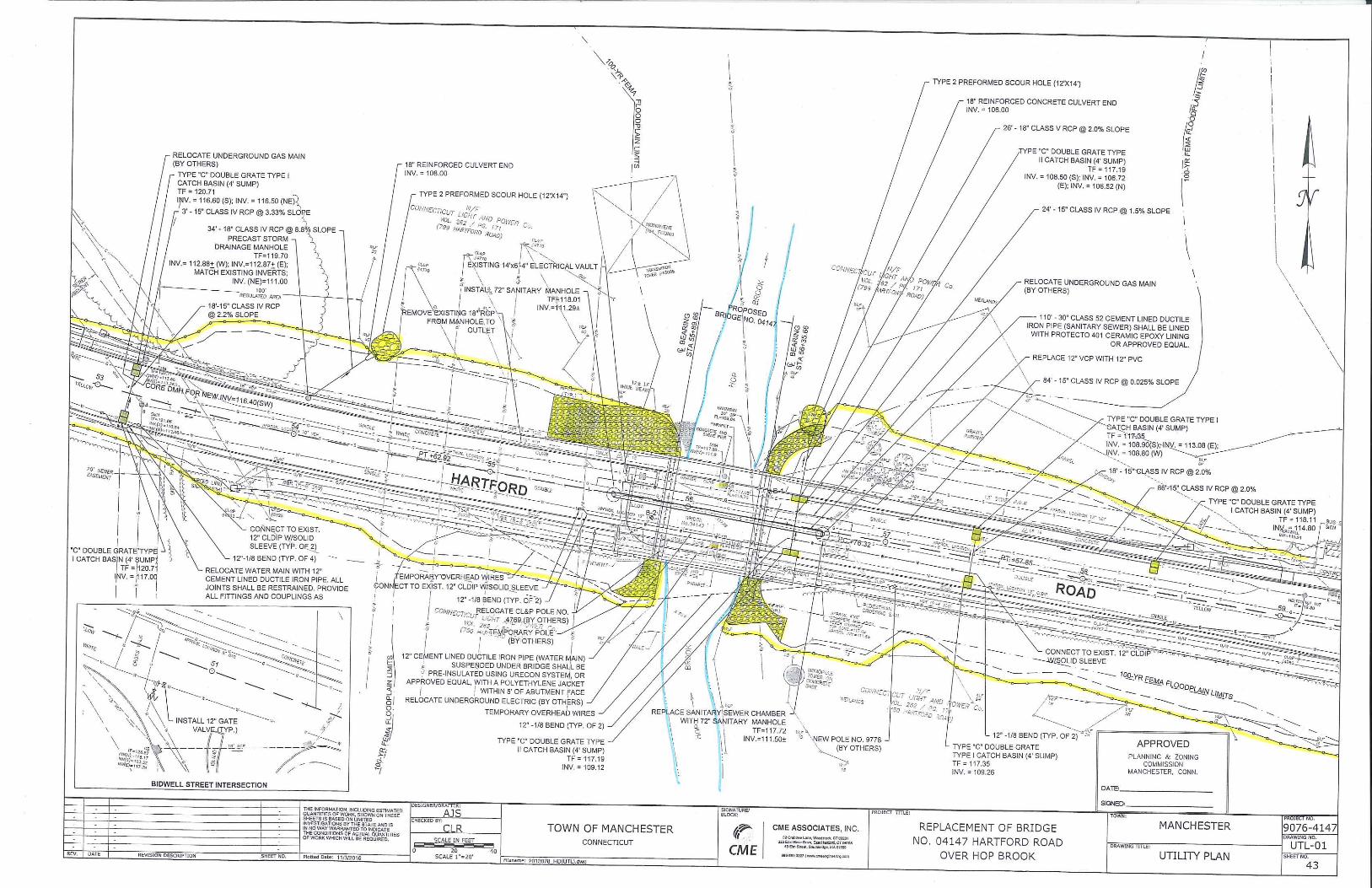
RE: Town of Manchester – Hartford Road Bridge
Inland Wetlands Permit (2016-135) and Determination of Significance
Erosion and Sedimentation Control (2016-136)
Flood Plain Permit (2016-137)
Introduction
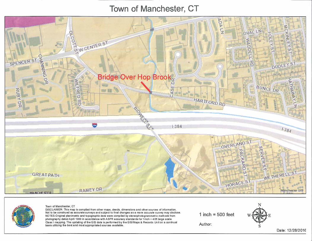
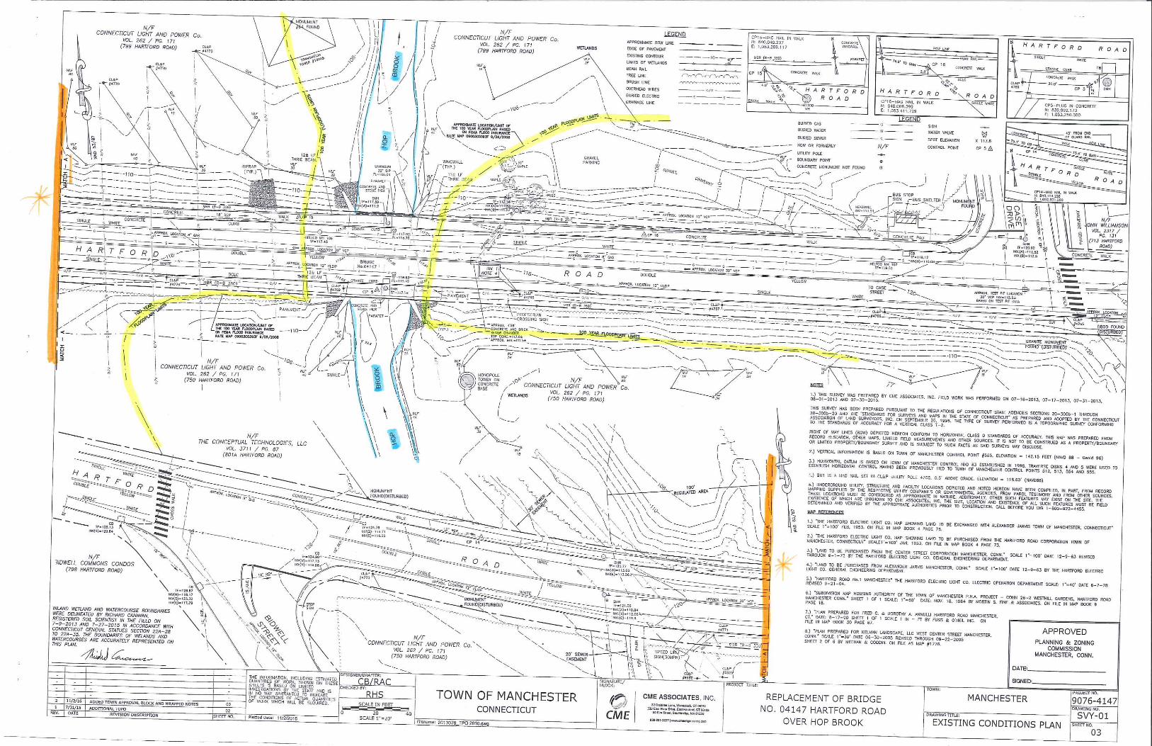
The Town of Manchester proposes to replace the existing bridge on Hartford Road over the Hop
Brook that was built in 1875 (see location map attached). CME Associates, Inc. has designed a
single span, steel girder bridge to replace the existing twin-arch bridge. The span will be 46 feet
with a clear opening of 42 feet and the deck will be three feet wider than the existing deck to
include additional space for a lane of the Charter Oak Greenway. The proposed bridge will
improve the passage of flood flows by raising the lowest part of the span over the watercourse,
eliminating the center pier and widening the opening to allow for a 100-year flow to pass under
the bridge.
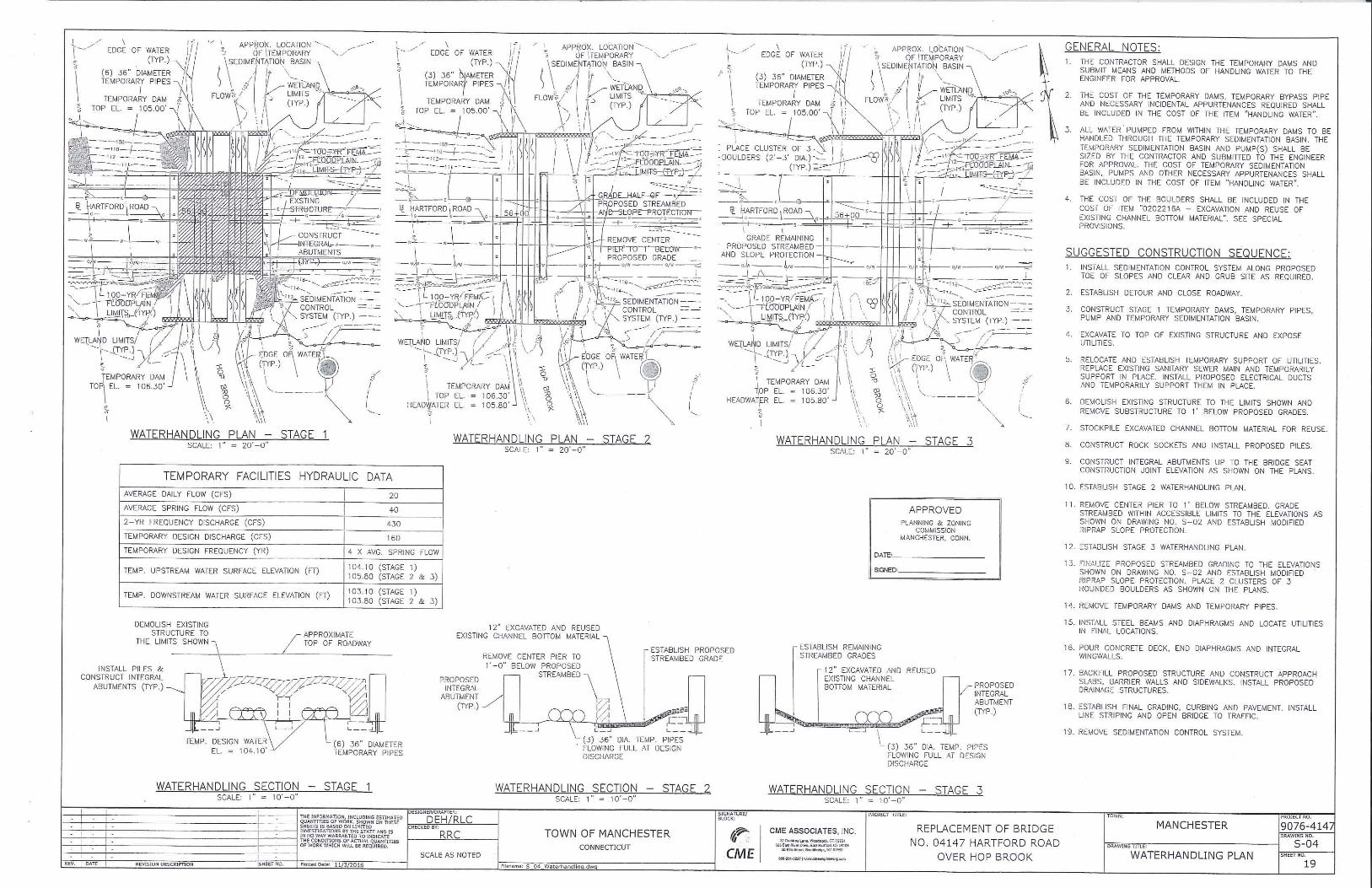
The project as proposed will require the full roadway closure and detour. The flow of the Hop
Brook will be handled with a set of six 36-inch high-density polyethylene (HDPE) pipes to allow
for continuous flow during demolition of the existing bridge as shown on Sheet No. 19 attached.
The pipes will protect the flowing water from demolition debris during removal of the existing
bridge and the construction of the new abutments. The water will be directed through three 36-
inch pipes, alternating each side of the channel as the other side is regraded. Following those
tasks the water handling pipes will be removed and the channel under the bridge will be regraded
with natural channel bed material to allow the stream to flow freely during construction of the
bridge. The project will limit unconfined work in the watercourse from the period of June 1st to
September 30th
.
Inland Wetlands Permit
The proposed bridge will span the Hop Brook (see Existing Conditions Plan Sheet No. 03
attached). CME Associates, Inc. state in the wetlands narrative that Hartford Road is constructed
on fill for the roadway approaches to the bridge from both the east and west. The roadway fill
was place in an area of wetlands and floodplain associated with the watercourse. The Hop Brook
flows westward along I-384 and then turns northward before flowing under Hartford Road and
continuing to the north. Stormwater runoff from the highway can result in a rapid increase of
December 28, 2016
Page 2 of 3
stream flows that may flood the wetlands adjacent to the channel. The vegetation in much of the
area is managed for the overhead electrical transmission lines and does not have tree cover.
CME Associates, Inc. state that the project will have very limited effects on wetland functions
and values in the project area. The two critical issues with the demolition of the arch structure
are alteration of the flood flows and impact to fish passage. This project is designed to avoid
long-term impacts to both flows and fish passage. The replacement of the structure with a
single-span structure will improve flood hydraulic performance by raising the low chord and
widening the opening. This allows for a 100-year flow to pass under the bridge. Additionally, as
described above, fish passage will be only temporarily confined to large pipes during the
demolition phase and substantially uninterrupted during construction of the bridge.
The removal of the center pier and existing abutments and wingwalls will require some
reconstruction to maintain the channel width and to provide appropriate substrate material. The
project design includes a riparian shelf along the east abutment to provide for wildlife habitat
movement and to match channel widths as the stream flows under the bridge. Channel bottom
material that is excavated as part of the demolition will be stockpiled for reuse, if additional
material is needed it will be supplemented with bank run gravel. The material will require
inspection by Town of Manchester staff before use in the channel. Existing concrete will be
removed from the channel where possible. This will provide a natural channel bottom through
the section under the bridge. As recommended by CT DEEP Fisheries, two clusters of three
rounded boulders, approximately 2-3 feet in diameter, will be placed in the stream to promote
fish habitat.
Determination of Significance
The Inland Wetlands Agency is required to make a determination of the significance of the
impact of the proposed activities on the wetlands, watercourses, and/or water bodies. In making
its determination, the Commission should be guided by the definition of "Significant Impact
Activity" as found in the Inland Wetlands and Watercourses Regulations which means any
activity, including, but not limited to, the following activities which may have a major effect or
significant impact:
a. Any activity involving a deposition or removal of material which will or may have a
substantial effect on the wetland or watercourse or on wetlands or watercourses outside the
area for which the activity is proposed; or
b. Any activity which substantially changes the natural channel or may inhibit the natural
dynamics of a watercourse system; or
c. Any activity which substantially diminishes the natural capacity of an inland wetland or
watercourse to support aquatic, plant or animal life, prevent flooding, supply water,
assimilate waste, facilitate drainage, provide recreation or open space or perform other
functions; or
d. Any activity which is likely to cause or has the potential to cause substantial turbidity,
siltation or sedimentation in a wetland or watercourse; or
December 28, 2016
Page 3 of 3
e. Any activity which causes a substantial diminution of flow of a natural watercourse or
groundwater levels of the wetland or watercourse; or
f. Any activity which is likely to cause or has the potential to cause pollution of a wetland or
watercourse; or
g. Any activity which damages or destroys unique wetland or watercourse areas or such areas
having demonstrable scientific or educational value.
If the Agency finds the proposed activity will have a significant impact on the wetlands, a public
hearing is required. Should the Agency find this activity will not create a significant impact,
then no public hearing is required.
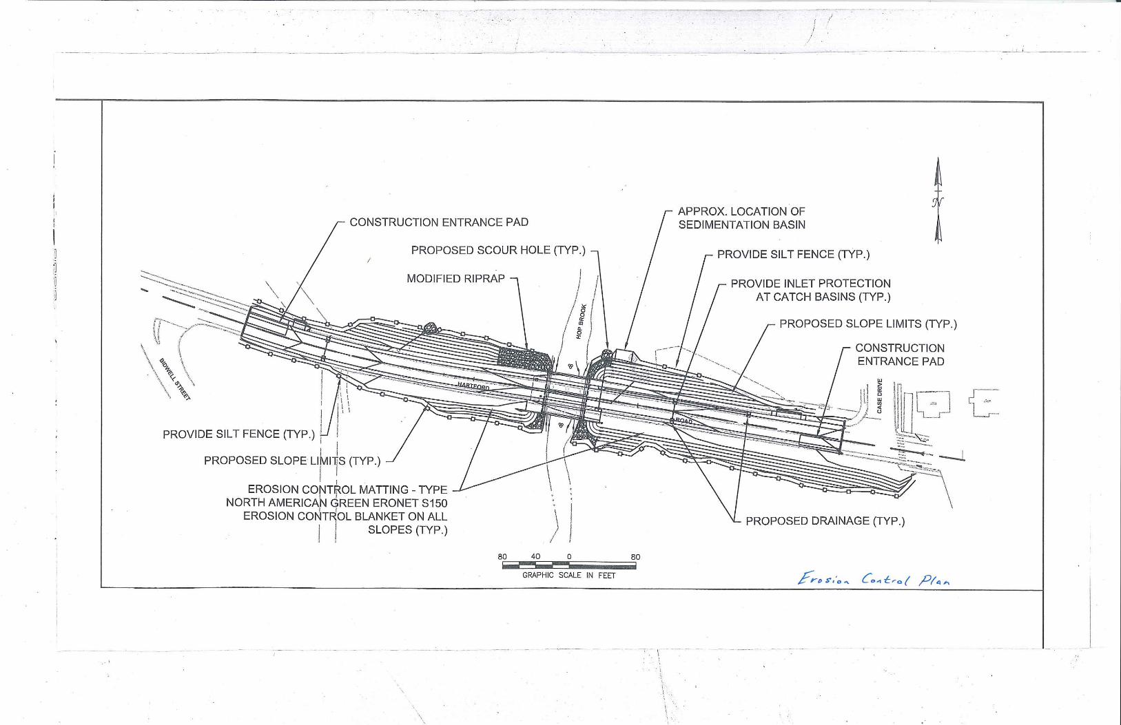
Erosion and Sedimentation Control
The project will include erosion and sedimentation controls including barriers at the limits of
disturbed soil, soil stabilization practices, treatment of dewatering wastewater and the
management of stormwater runoff from Hartford Road while improvements to the drainage
system are made. Erosion and sedimentation control measures are shown on the Erosion Control
Plan attached.
Flood Plain Permit
The impacts of the proposed project in regulated flood plain are described above. The regulated
100-year floodplain limits are highlighted in yellow on the Existing Conditions Plan Sheet No.
03 attached). Removal of the existing twin-arch bridge with a single span will eliminate an
obstruction in the middle of the stream channel. The length of the span will also widen the
channel, increase the hydraulic performance and providing a riparian shelf for wildlife passage
under the bridge. Finally, the lowest horizontal structural member of the steel-girder bridge will
be raised in comparison to the existing arch-style bridge further removing potential conflicts with
the passage of stormwater under most extreme weather events.
Staff Review
The application plans and documents were reviewed by Town staff. Staff was substantially
satisfied with the original submittal of the application materials and there are no outstanding
comments.
MRB R:\Planning\PZC\2017\01 - January 4\Packet Memos\2016-135-137 Bridge.docx
Attachments