Invisible Occupation: Indigenous Natural Resource ...
1
Invisible Occupation: Indigenous Natural Resource Management in the Peruvian Amazon Aleah Goldin*, Yazmeen Nuñez*, David S. Salisbury*^, James Águila Soria^, Raquel Espinosa Linares^, Enzo Pinedo Ramírez^, Luís Rosero Flores^, Miguel Nuñez Sánchez^, Gerardo Cavero Oroche^, Jorge Vela Alvarado^, Oscar Barreto Vásquez^, Giraldo Almeida Villanueva^, Carlos Pérez Alván^ Spatial Analysis Laboratory, Department of Geography and the Environment, University of Richmond Centro de Investigación de Fronteras Amazónicas, Universidad Nacional de Ucayali Research Symposium, University of Richmond, VA, April 15, 2011 On June 5th 2009, an estimated thirty people died in a clash between governmental authorities and indigenous people near Bagua, Peru. Termed the "Bagua Massacre," this event underscores the marginalized role of Indigenous Amazonians when confronting multinational commercial interests supported by the state (Shepard, 2009). The indigenous people were protesting the “Law of the Jungle,” Decree 1090, a 2009 decree assuming heavily-forested indigenous lands idle and unproductive, and providing the legal basis to privatize comunally-held forests to facilitate petroleum, biofuel, hydroelectric and logging projects. Since contact, the assumption of indigenous people unproductively managing their forested homelands has fueled colonization, deforestation, and the displacement of indigenous residents. Our research uses Global Positioning System receivers (GPS) and a Geographic Information System (GIS) to provide a snapshot of indigenous management of natural resources not only in their readily visible agricultural fields, but also beneath the forest canopy and within lakes and river courses. Village Layout: The spatial organization of dwellings in San Fernando followed a linear pattern, where homes are placed alongside one another in rows (Figure 8). In San Martín, clusters of houses were organically distributed alongside the river with distances between houses reaching up to four kilometers (Figure 7). Fishing Areas: The residents of San Fernando, their village 800 meters from a major river in the dry season, fish as close as 500 meters from the village center and as far as 8 kilometers to extract fish for daily consumption and nearby markets. Fishing in and around San Fernando is clustered around lakes and river sites deemed rich in fish, with as many as five different fishing spots within a 200 meter radius, while large spans of the river are rarely accessed (Figure 6). Residents of the riverside village of San Martín fish along the thirteen kilometers of river and lakes proximate to the village (Figure 9). Forest Extraction: Most timber extraction sites in San Fernando are within 1.5 kilometers of the village homes (Figure 6). This selective extraction occurs underneath the forest canopy, not readily visible in satellite imagery (Figure 6). Hunting, an important source of protein, took place both in the interior of the forest and at the interface between fields and forest. In San Martín, selective logging, palm management and hunting sites also extend under the forest canopy (Figure 9). Timber and game management occurs farther from the village center in San Martín than in San Fernando, although in both cases, there is a significant amount of logging and hunting around residences. Figure 1: Community member at a fishing hole in San Martín. Credit: James Águila Soria Figure 2: UNU thesis students, who conducted fieldwork with GPS, use GIS to analyze their field data. Credit: David Salisbury Figure 3: Community member pulling up manioc from a home garden in San Martín. Credit: Enzo Pinedo Ramírez Figure 6: Resource management by San Fernando community sample. Figure 5: San Fernando child carrying fish home. Credit: Miguel Nuñez Sánchez Figure 4: San Martín resident rounding out a tree trunk to facilitate transport downriver for sale. Credit: Gerardo Cavero Oroche Figure 8: Agriculture in San Fernando. Figure 7: Agriculture in San Martín. Figure 9: Resource management by San Martín community sample. Introduction Resource Management Hames, Raymond (2007, May 30). The Ecologically Noble Savage Debate. Annual Review of Anthropology, Volume 36, 177-190. Nepstad, D., S. Schwartzman, B. Bamberger, M. Santilli, D. Ray, P. Schlesinger, P. Lefebvre, et al. (2006). Inhibition of Amazon deforestation and fire by parks and indigenous lands. Conservation Biology 20 (1) (02): 65-73. Oliveira, Paulo J. C., Gregory P. Asner, David E. Knapp, Angélica Almeyda, Ricardo Galván-Gildemeister, Sam Keene, Rebecca F. Raybin, and Richard C. Smith. (2007). Land-use allocation protects the Peruvian Amazon. Science 317 (5842) (August 31): 1233-6. Perez C, Borgo J, Parraga W, Paredes R, Ramirez E, Salisbury D, Diaz Z E, Vela A J, Almeida V G, Limache A A, Cuentas M. La Frontera Central Peru-Brasil: Análisis de la Realidad Geográfica y las Posibilidades para la Conservacion. Centro de Investigacion de Fronteras Amazonicas (CIFA) y Universidad Nacional de Ucayali (UNU). Romero, Simon (2009, June 6). Fatal clashes erupt in Peru at roadblock. The New York Times. Romero, Simon (2009, June 19). Peru overturns decrees that incited protests. The New York Times. Salisbury, David. S., and M. Schmink. (2007). Cows versus rubber: Changing livelihoods among amazonian extractivists. Geoforum 38 (6) (NOV): 1233-49. Salisbury, David S. (2009). Amazonia for Amazonians: Natural Resource Management and Capacity Building in the Peruvian Amazon. Fulbright Grant Proposal #0556.. Salisbury David S, Lopez, Borgo J, Alvarado J W (2011). Transboundary political ecology in Amazonia: history, culture, and conflicts of the borderland Ashaninka. Journal of Cultural Geography, Volume 28, No 1, 147-177. Shepard, Glenn H. (2009). Indigenous people defend rainforest as well as their rights. Nature 460 (7254) (07/23): 457-. Remote sensing using satellite imagery appears a logical, efficient, and readily available method for the Peruvian government to determine whether indigenous territories are being used productively or not. Satellite imagery is increasingly used to monitor Amazon deforestation (Nepstad et al., 2005) and land-use (Oliveira et al., 2007) because of increasing accessibility and affordability. However, this research underscores the extensive nature of resource use of two indigenous Amazonian villages and the challenge of discerning resource management under the forest canopy and along watercourses when analyzing remotely rather than using fieldwork (Figures 6 and 9). Traditional Amazonians have productively used the forest and fisheries for sustenance and sale for centuries, and their natural resource management cannot easily be captured by remote sensing or deforestation-based definitions of productivity. This poster has been translated and returned to the communities as a natural resource management tool and to continue collaboration between the communities, CIFA-UNU, and UR. Conclusion References The two indigenous villages of San Fernando and San Martín (pseudonyms) chosen for this study are different in terms of ethnicity (Shipibo Conibo and Ashéninka), physical geography (floodplain and terra firme), and proximity to urban markets (8 hours and 3 days by boat) so that we may better capture some of the heterogeneity of indigenous natural resource management in the Peruvian Amazon. To understand the spatial extent of natural resource management in the two villages, we concentrated on the topics of fishing, forestry (timber, non- timber forest products, and hunting), and agriculture: all central to subsistence and/or income generation in traditional Amazonian communities (Salisbury and Schmink 2007). Agricultural Plots: Agriculture occurs closer to the village center than fishery and forestry management in both San Fernando and San Martín. In San Fernando, agricultural fields are located as close as 175 meters away from the village center to as far as 2.5 kilometers. Home gardens, which grow a variety of consumable goods for a household, are established within fifteen meters of the owner's house (Figure 8). In San Martín, the closest agricultural fields are 3 meters from the village center and as far as 500 meters from the nearest owner's house. Home garden space is not as well-defined as in San Martín; they are scattered among the agricultural fields and pastures (Figure 7). Study Sites Resource Management Continued Fieldwork was conducted by undergraduate thesis students of the Universidad Nacional de Ucyali’s Centro de Investigación de Fronteras Amazónicas. Each student stayed two months in each village, rotating between households. Households were selected to capture the diversity of age, gender, residence length, and geographic location in the villages. Methods used in the field included landscape walks with key informants (along hunting, fishing, forestry, and agriculture routes) and GPS, participant observation, participatory mapping, land use mapping, and semi-structured interviews. Preliminary data organization occurred in CIFA-UNU with GPS Trackmaker and ArcGIS 9.2 before data was further cleaned, organized, and analyzed in the Spatial Analysis Laboratory by University of Richmond undergraduates Goldin and Nunez in ArcGIS 10. A Landsat 5 Path 6, Row 66, May 2010 satellite image facilitated analysis. Methodology
Transcript of Invisible Occupation: Indigenous Natural Resource ...
Invisible Occupation: Indigenous Natural Resource Management in the Peruvian Amazon Aleah Goldin*, Yazmeen Nuñez*, David S. Salisbury*^, James Águila Soria^, Raquel Espinosa Linares^, Enzo Pinedo Ramírez^, Luís Rosero Flores^, Miguel Nuñez Sánchez^, Gerardo Cavero Oroche^, Jorge Vela Alvarado^, Oscar Barreto Vásquez^, Giraldo Almeida Villanueva^,
Carlos Pérez Alván^ Spatial Analysis Laboratory, Department of Geography and the Environment, University of Richmond
Centro de Investigación de Fronteras Amazónicas, Universidad Nacional de Ucayali Research Symposium, University of Richmond, VA, April 15, 2011
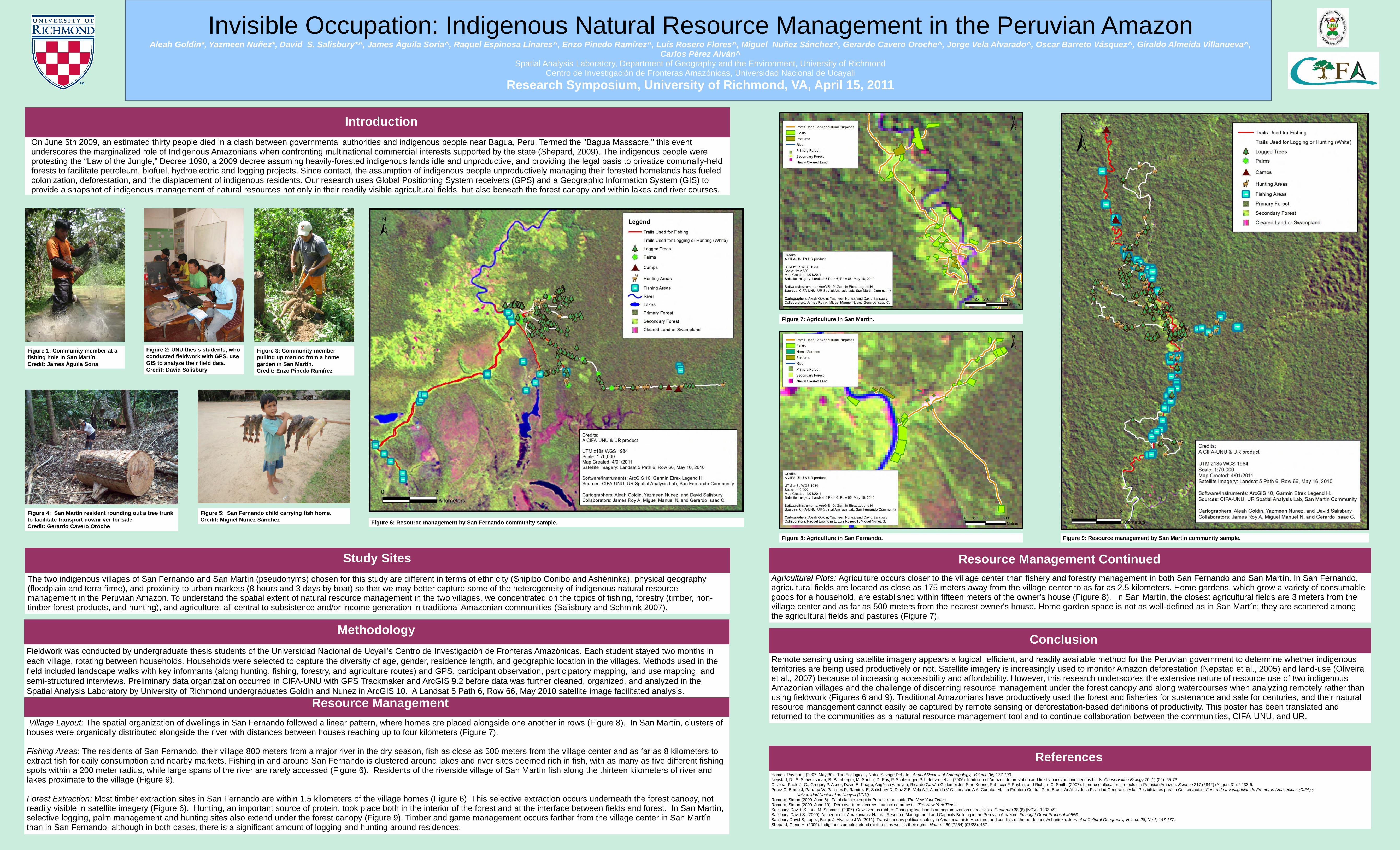
On June 5th 2009, an estimated thirty people died in a clash between governmental authorities and indigenous people near Bagua, Peru. Termed the "Bagua Massacre," this event underscores the marginalized role of Indigenous Amazonians when confronting multinational commercial interests supported by the state (Shepard, 2009). The indigenous people were protesting the “Law of the Jungle,” Decree 1090, a 2009 decree assuming heavily-forested indigenous lands idle and unproductive, and providing the legal basis to privatize comunally-held forests to facilitate petroleum, biofuel, hydroelectric and logging projects. Since contact, the assumption of indigenous people unproductively managing their forested homelands has fueled colonization, deforestation, and the displacement of indigenous residents. Our research uses Global Positioning System receivers (GPS) and a Geographic Information System (GIS) to provide a snapshot of indigenous management of natural resources not only in their readily visible agricultural fields, but also beneath the forest canopy and within lakes and river courses.
Village Layout: The spatial organization of dwellings in San Fernando followed a linear pattern, where homes are placed alongside one another in rows (Figure 8). In San Martín, clusters of houses were organically distributed alongside the river with distances between houses reaching up to four kilometers (Figure 7). Fishing Areas: The residents of San Fernando, their village 800 meters from a major river in the dry season, fish as close as 500 meters from the village center and as far as 8 kilometers to extract fish for daily consumption and nearby markets. Fishing in and around San Fernando is clustered around lakes and river sites deemed rich in fish, with as many as five different fishing spots within a 200 meter radius, while large spans of the river are rarely accessed (Figure 6). Residents of the riverside village of San Martín fish along the thirteen kilometers of river and lakes proximate to the village (Figure 9). Forest Extraction: Most timber extraction sites in San Fernando are within 1.5 kilometers of the village homes (Figure 6). This selective extraction occurs underneath the forest canopy, not readily visible in satellite imagery (Figure 6). Hunting, an important source of protein, took place both in the interior of the forest and at the interface between fields and forest. In San Martín, selective logging, palm management and hunting sites also extend under the forest canopy (Figure 9). Timber and game management occurs farther from the village center in San Martín than in San Fernando, although in both cases, there is a significant amount of logging and hunting around residences.
Figure 1: Community member at a fishing hole in San Martín. Credit: James Águila Soria
Figure 2: UNU thesis students, who conducted fieldwork with GPS, use GIS to analyze their field data. Credit: David Salisbury
Figure 3: Community member pulling up manioc from a home garden in San Martín. Credit: Enzo Pinedo Ramírez
Figure 6: Resource management by San Fernando community sample. Figure 5: San Fernando child carrying fish home. Credit: Miguel Nuñez Sánchez
Figure 4: San Martín resident rounding out a tree trunk to facilitate transport downriver for sale. Credit: Gerardo Cavero Oroche
Figure 8: Agriculture in San Fernando.
Figure 7: Agriculture in San Martín.
Figure 9: Resource management by San Martín community sample.
Introduction
Resource Management
Hames, Raymond (2007, May 30). The Ecologically Noble Savage Debate. Annual Review of Anthropology, Volume 36, 177-190. Nepstad, D., S. Schwartzman, B. Bamberger, M. Santilli, D. Ray, P. Schlesinger, P. Lefebvre, et al. (2006). Inhibition of Amazon deforestation and fire by parks and indigenous lands. Conservation Biology 20 (1) (02): 65-73. Oliveira, Paulo J. C., Gregory P. Asner, David E. Knapp, Angélica Almeyda, Ricardo Galván-Gildemeister, Sam Keene, Rebecca F. Raybin, and Richard C. Smith. (2007). Land-use allocation protects the Peruvian Amazon. Science 317 (5842) (August 31): 1233-6. Perez C, Borgo J, Parraga W, Paredes R, Ramirez E, Salisbury D, Diaz Z E, Vela A J, Almeida V G, Limache A A, Cuentas M. La Frontera Central Peru-Brasil: Análisis de la Realidad Geográfica y las Posibilidades para la Conservacion. Centro de Investigacion de Fronteras Amazonicas (CIFA) y Universidad Nacional de Ucayali (UNU). Romero, Simon (2009, June 6). Fatal clashes erupt in Peru at roadblock. The New York Times. Romero, Simon (2009, June 19). Peru overturns decrees that incited protests. The New York Times. Salisbury, David. S., and M. Schmink. (2007). Cows versus rubber: Changing livelihoods among amazonian extractivists. Geoforum 38 (6) (NOV): 1233-49. Salisbury, David S. (2009). Amazonia for Amazonians: Natural Resource Management and Capacity Building in the Peruvian Amazon. Fulbright Grant Proposal #0556.. Salisbury David S, Lopez, Borgo J, Alvarado J W (2011). Transboundary political ecology in Amazonia: history, culture, and conflicts of the borderland Ashaninka. Journal of Cultural Geography, Volume 28, No 1, 147-177. Shepard, Glenn H. (2009). Indigenous people defend rainforest as well as their rights. Nature 460 (7254) (07/23): 457-.
Remote sensing using satellite imagery appears a logical, efficient, and readily available method for the Peruvian government to determine whether indigenous territories are being used productively or not. Satellite imagery is increasingly used to monitor Amazon deforestation (Nepstad et al., 2005) and land-use (Oliveira et al., 2007) because of increasing accessibility and affordability. However, this research underscores the extensive nature of resource use of two indigenous Amazonian villages and the challenge of discerning resource management under the forest canopy and along watercourses when analyzing remotely rather than using fieldwork (Figures 6 and 9). Traditional Amazonians have productively used the forest and fisheries for sustenance and sale for centuries, and their natural resource management cannot easily be captured by remote sensing or deforestation-based definitions of productivity. This poster has been translated and returned to the communities as a natural resource management tool and to continue collaboration between the communities, CIFA-UNU, and UR.
Conclusion
References
The two indigenous villages of San Fernando and San Martín (pseudonyms) chosen for this study are different in terms of ethnicity (Shipibo Conibo and Ashéninka), physical geography (floodplain and terra firme), and proximity to urban markets (8 hours and 3 days by boat) so that we may better capture some of the heterogeneity of indigenous natural resource management in the Peruvian Amazon. To understand the spatial extent of natural resource management in the two villages, we concentrated on the topics of fishing, forestry (timber, non-timber forest products, and hunting), and agriculture: all central to subsistence and/or income generation in traditional Amazonian communities (Salisbury and Schmink 2007).
Agricultural Plots: Agriculture occurs closer to the village center than fishery and forestry management in both San Fernando and San Martín. In San Fernando, agricultural fields are located as close as 175 meters away from the village center to as far as 2.5 kilometers. Home gardens, which grow a variety of consumable goods for a household, are established within fifteen meters of the owner's house (Figure 8). In San Martín, the closest agricultural fields are 3 meters from the village center and as far as 500 meters from the nearest owner's house. Home garden space is not as well-defined as in San Martín; they are scattered among the agricultural fields and pastures (Figure 7).
Study Sites Resource Management Continued
Fieldwork was conducted by undergraduate thesis students of the Universidad Nacional de Ucyali’s Centro de Investigación de Fronteras Amazónicas. Each student stayed two months in each village, rotating between households. Households were selected to capture the diversity of age, gender, residence length, and geographic location in the villages. Methods used in the field included landscape walks with key informants (along hunting, fishing, forestry, and agriculture routes) and GPS, participant observation, participatory mapping, land use mapping, and semi-structured interviews. Preliminary data organization occurred in CIFA-UNU with GPS Trackmaker and ArcGIS 9.2 before data was further cleaned, organized, and analyzed in the Spatial Analysis Laboratory by University of Richmond undergraduates Goldin and Nunez in ArcGIS 10. A Landsat 5 Path 6, Row 66, May 2010 satellite image facilitated analysis.
Methodology