應用降雨特性評估雨量估計方法及其應用 · 颱風有125 場,其餘為暴雨事件。1190 場降雨 事件中,僅有78 場事件具有14 個雨量測站之完 全記錄,其中颱風事件有23

豪雨(暴雨)與颱風研究-海峽地區地形影響颱颱多尺度動力機制研究
2011年兩岸氣象科學合作研究期中成果研討會
計畫主持人:郭鴻基 教授 張智北 教授 葉天降 副局長
時間:2011. 08. 07
1
2
海峽兩岸大氣科學合作研究
研究題目﹕
颱颱多尺度動力機制研究 研究人員﹕
臺灣
郭鴻基 臺灣大學
葉天降 中央氣象局
王重傑 臺灣師範大學
簡芳菁 臺灣師範大學
劉清煌 中國文化大學
研究題目﹕
二十世紀中期以來中國大陸和台灣夏季季風與颱風降雨
研究人員﹕
臺灣
張智北 台灣大學
隋中興 台灣大學
湯寶君 台灣大學
大陸
雷永薈 中國科學院遙感應用所
林小紅 福建省氣象局
任福民 中國氣象局國家氣候中心
大陸
雷小途 上海颱風研究所
余暉副 上海颱風研究所
李永平 上海颱風研究所
李青青 上海颱風研究所
鮑旭煒 上海颱風研究所

OUTLINES
•Introduction – 50 years of rainfall data
•Typhoon interaction with monsoon ; mesoscale convections
•Slow movement Typhoon
•Rainfall and typhoon translation speed
•Typhoon Haitang -- heavy rainfall pre & post landfall period
•Summary

1960至2010(50年)侵台颱風路徑共84個颱風。
颱風強度資料中央氣象局侵台颱風資料庫之颱風總表裡的颱風中心近台灣1緯度內近颱風中心最大風速。
雨量資料則使用21個擁有1960到2010資料長度之局屬測站時雨量資料。
氣象局局屬測站分布圖
4
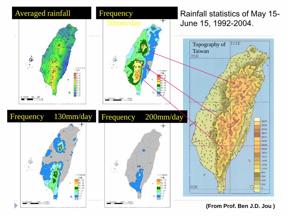
5/15-6/15, 1992-2004
Averaged rainfall Frequency
50mm/day
Frequency 130mm/day Frequency 200mm/day
5/15-6/15, 1992-2004
5/15-6/15, 1992-2004 5/15-6/15, 1992-2004
Topography of
Taiwan
Rainfall statistics of May 15-
June 15, 1992-2004.
(From Prof. Ben J.D. Jou )
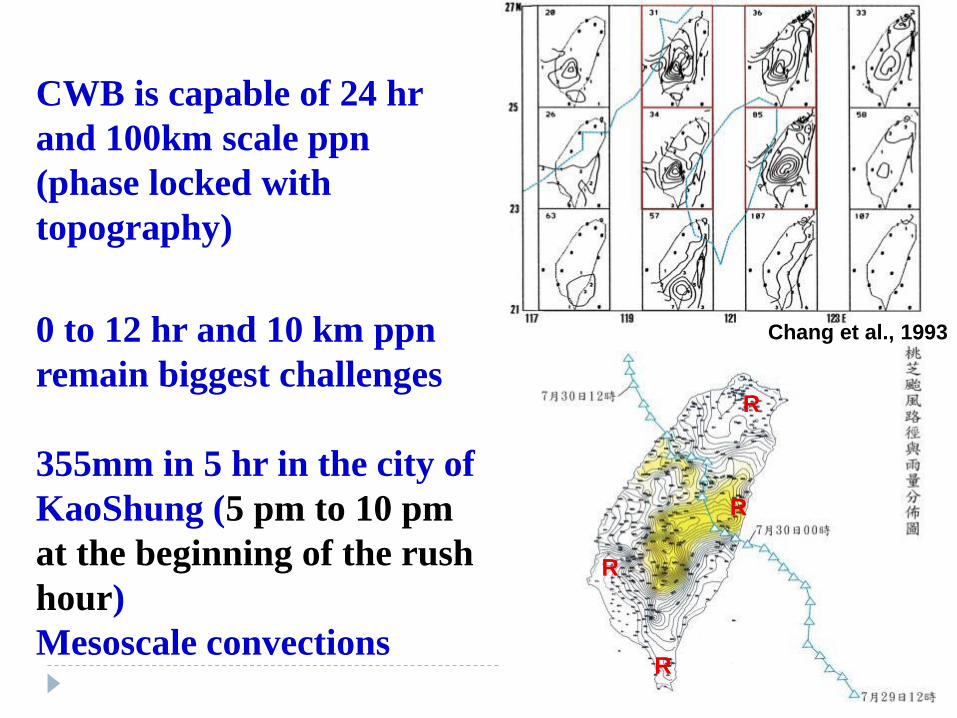
CWB is capable of 24 hr
and 100km scale ppn
(phase locked with
topography)
0 to 12 hr and 10 km ppn
remain biggest challenges
355mm in 5 hr in the city of
KaoShung (5 pm to 10 pm
at the beginning of the rush
hour)
Mesoscale convections
R
R
R
R
Chang et al., 1993

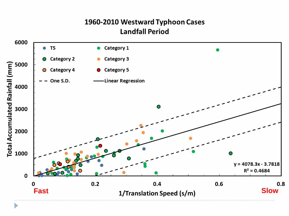
1960-2010 Total Accumulated Rainfall Amount (Landfall Period)
Slow Fast
strong
weak
Slow Fast
Chien and Kuo, 2010
Slow Fast
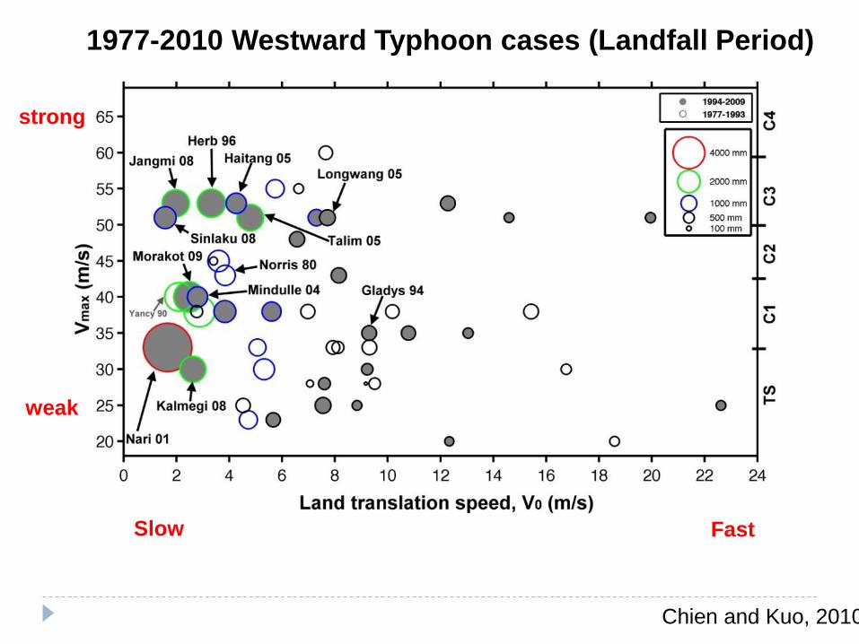
1977-2010 Westward Typhoon cases (Landfall Period)
weak
strong
Chien and Kuo, 2010
Slow Fast
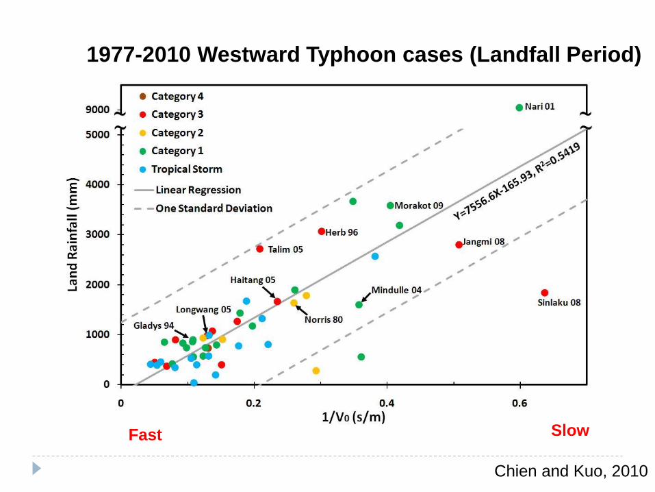
1977-2010 Westward Typhoon cases (Landfall Period)

Pre-landfall + Land ≥ 2000 mm

12
Post-landfall + Land ≥ 2000 mm
Chien and Kuo, 2010
Slow Fast
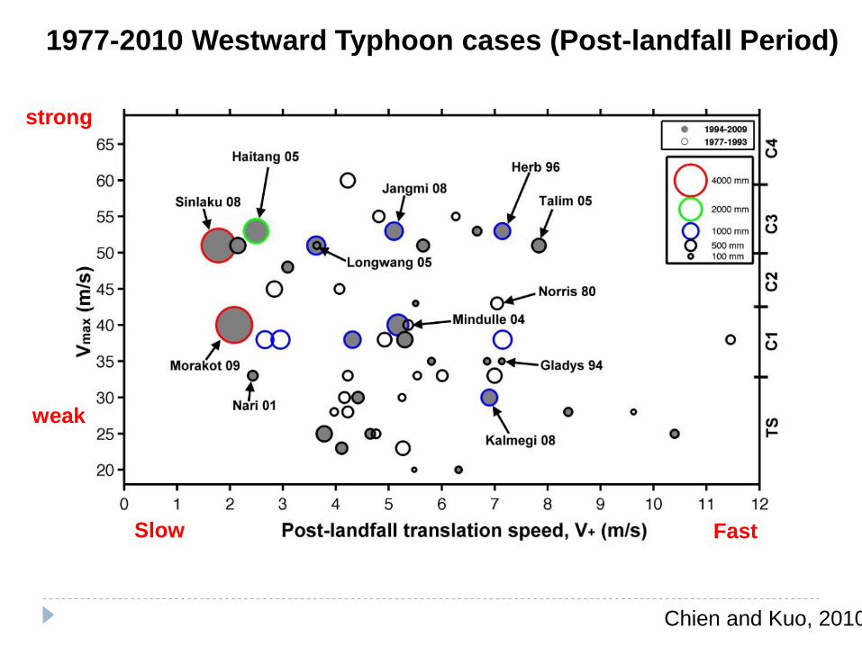
1977-2010 Westward Typhoon cases (Post-landfall Period)
weak
strong
Chien and Kuo, 2010
Slow Fast
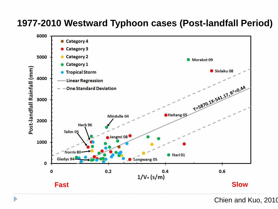
1977-2010 Westward Typhoon cases (Post-landfall Period)
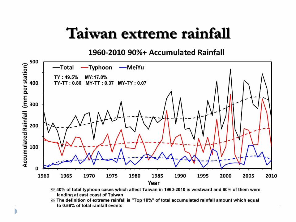
Taiwan extreme rainfall
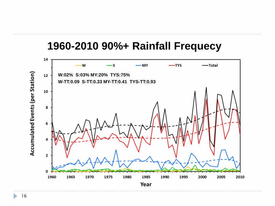
1960-2010 90%+ Rainfall Frequecy
W:02% S:03% MY:20% TYS:75%
W-TT:0.09 S-TT:0.33 MY-TT:0.41 TYS-TT:0.93
16

1960-2010 90%+ Rainfall Events (Landfall Period)
Slow Fast
strong
weak
Slow Fast
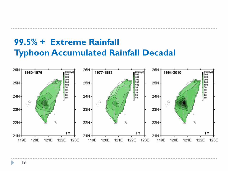
99.5% + Extreme Rainfall
Typhoon Accumulated Rainfall Decadal
19
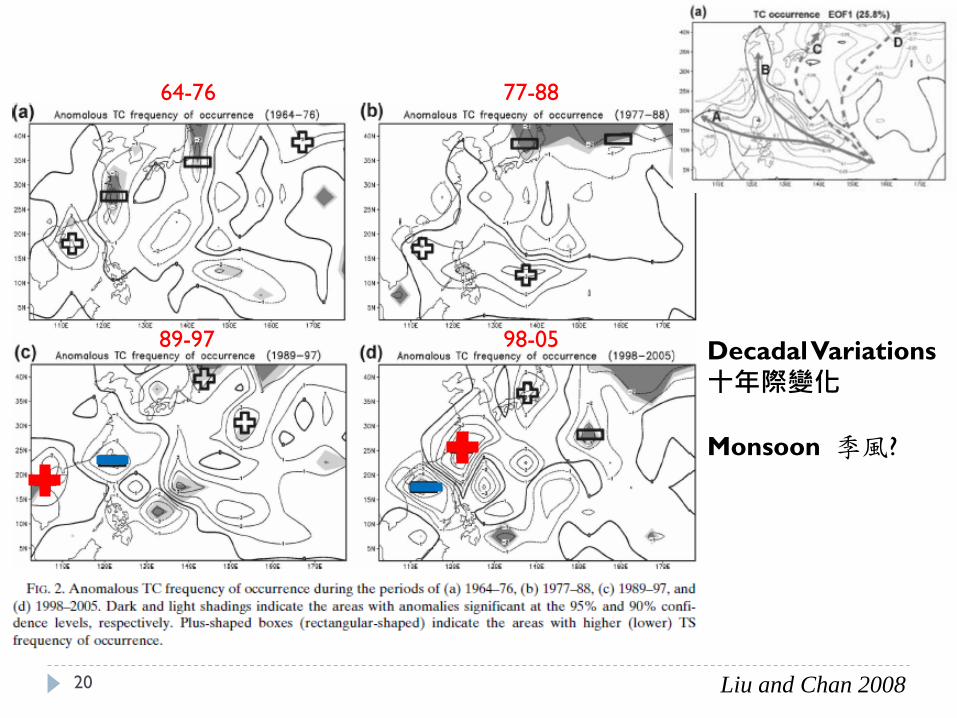
Liu and Chan 2008
64-76 77-88
89-97 98-05 Decadal Variations
十年際變化
Monsoon 季風?
20
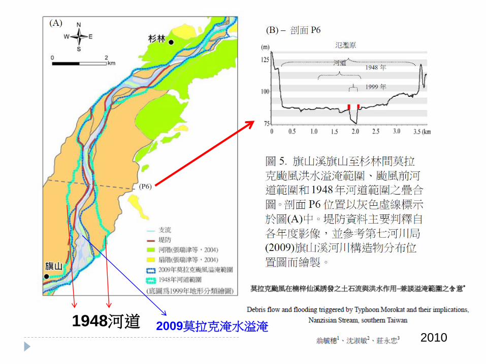
2010
1948河道 2009莫拉克淹水溢淹

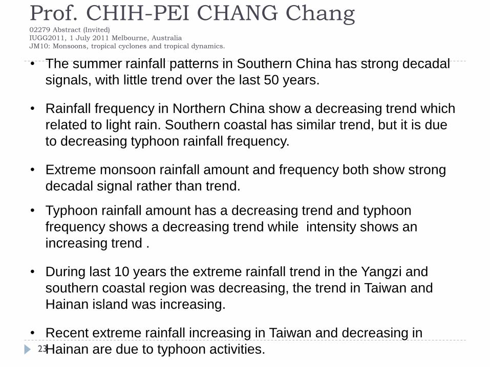
Prof. CHIH-PEI CHANG 02279 Abstract (Invited)
IUGG2011, 1 July 2011 Melbourne, Australia
JM10: Monsoons, tropical cyclones and tropical dynamics.
Long-term trend and decadal variations of monsoon rainfall in the
China summer monsoon region over the last six decades.
A dominant declining trend of the lowest 20% daily rainfall rate (a
signature of global warming as a result of increased static stability).
The highest 10% daily rainfall rate exhibits substantial decadal
variations. (Lei, Hoskins and Slingo, 2011).
In regions of tropical cyclone (TC) activity both the accumulated
rainfall amount and intensity are significantly affected by the TCs,
particularly in their main path covering Taiwan and the southeastern
coast of mainland China.
The variable TC numbers and tracks contribute to local decadal
variations of the extremely intense rainfall.
22
Prof. CHIH-PEI CHANG Chang 02279 Abstract (Invited)
IUGG2011, 1 July 2011 Melbourne, Australia
JM10: Monsoons, tropical cyclones and tropical dynamics.
23
• The summer rainfall patterns in Southern China has strong decadal
signals, with little trend over the last 50 years.
• Rainfall frequency in Northern China show a decreasing trend which
related to light rain. Southern coastal has similar trend, but it is due
to decreasing typhoon rainfall frequency.
• Extreme monsoon rainfall amount and frequency both show strong
decadal signal rather than trend.
• Typhoon rainfall amount has a decreasing trend and typhoon
frequency shows a decreasing trend while intensity shows an
increasing trend .
• During last 10 years the extreme rainfall trend in the Yangzi and
southern coastal region was decreasing, the trend in Taiwan and
Hainan island was increasing.
• Recent extreme rainfall increasing in Taiwan and decreasing in
Hainan are due to typhoon activities.
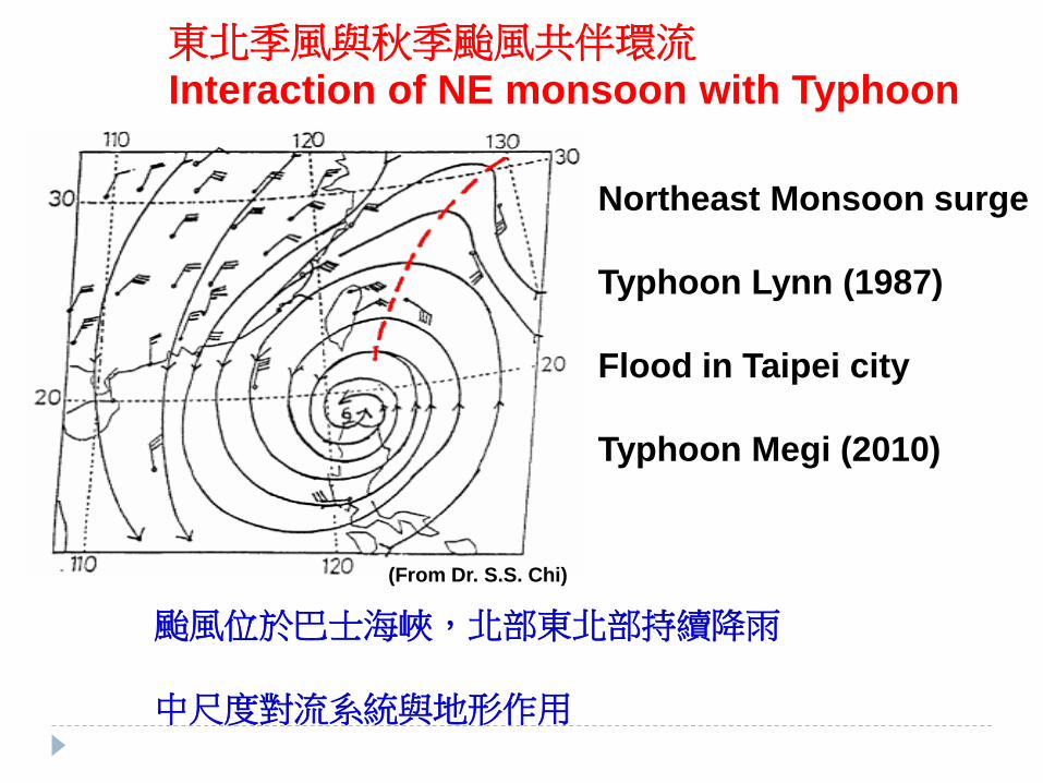
颱風位於巴士海峽,北部東北部持續降雨
中尺度對流系統與地形作用
1987年琳恩颱風
台北市淹大水
東北季風與秋季颱風共伴環流
Interaction of NE monsoon with Typhoon
Northeast Monsoon surge
Typhoon Lynn (1987)
Flood in Taipei city
Typhoon Megi (2010)
(From Dr. S.S. Chi)
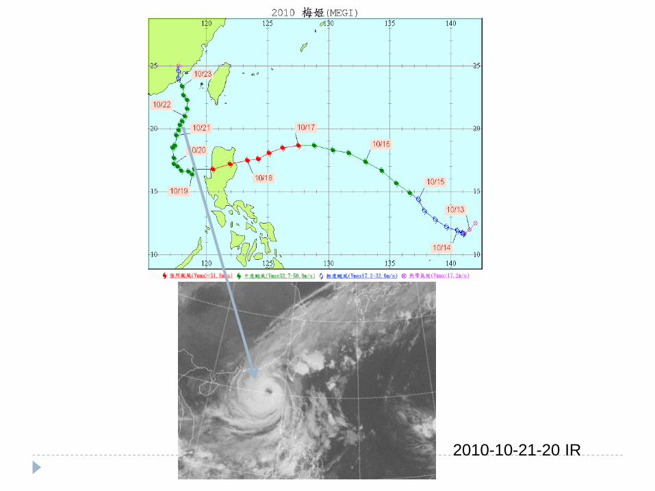
2010-10-21-20 IR
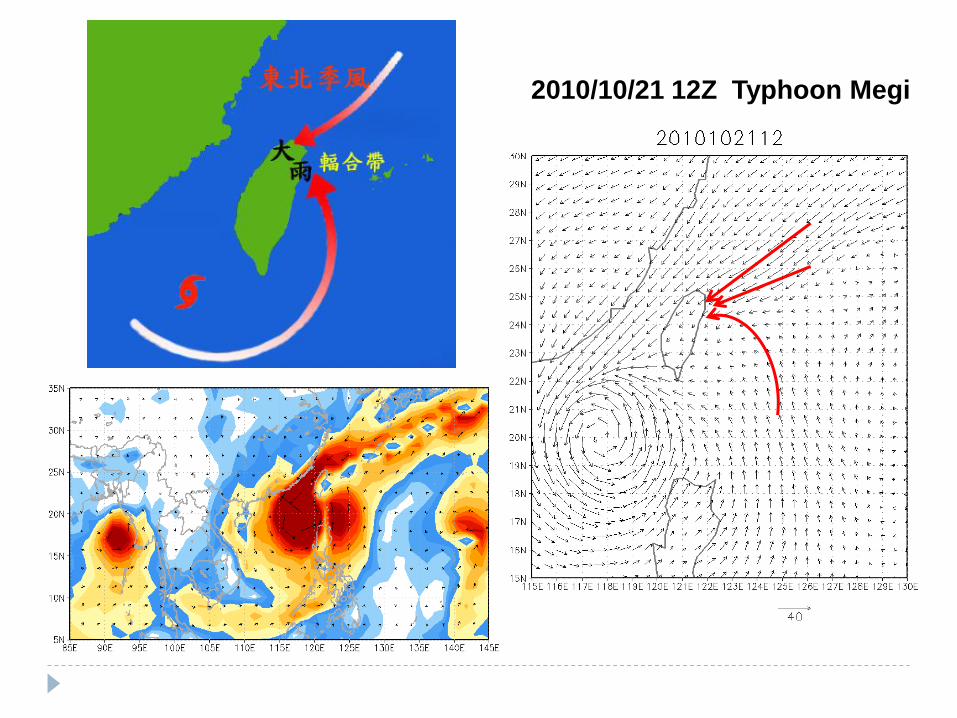
2010/10/21 12Z Typhoon Megi

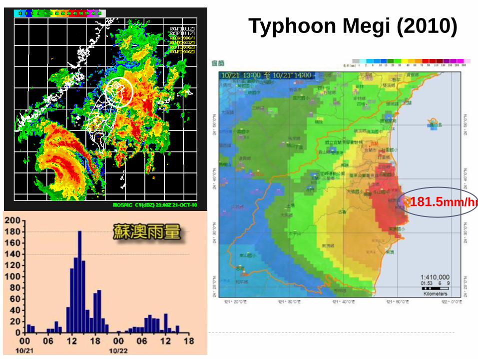
181.5mm/hr
Typhoon Megi (2010)

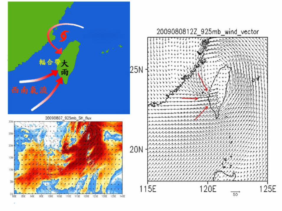
2009/8/7 CloudSat
Deep convections
in sourth
Chien and Kuo, 2010
Typhoon
Morakot (2009)

Before After 700 people perished
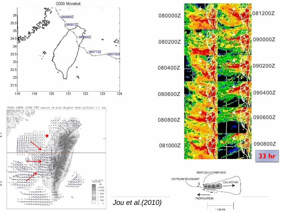
33 hr
Jou et al.(2010)
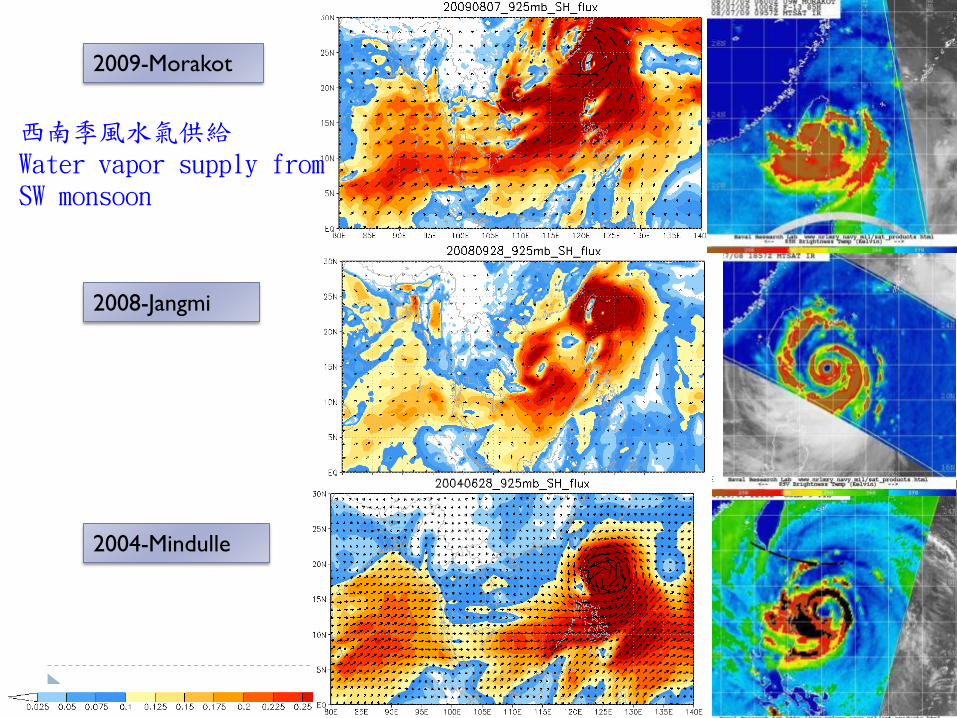
2009-Morakot
2008-Jangmi
2004-Mindulle
西南季風水氣供給 Water vapor supply from SW monsoon
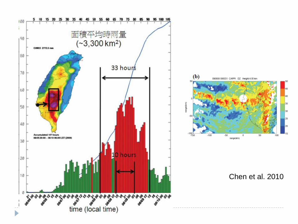
Chen et al. 2010
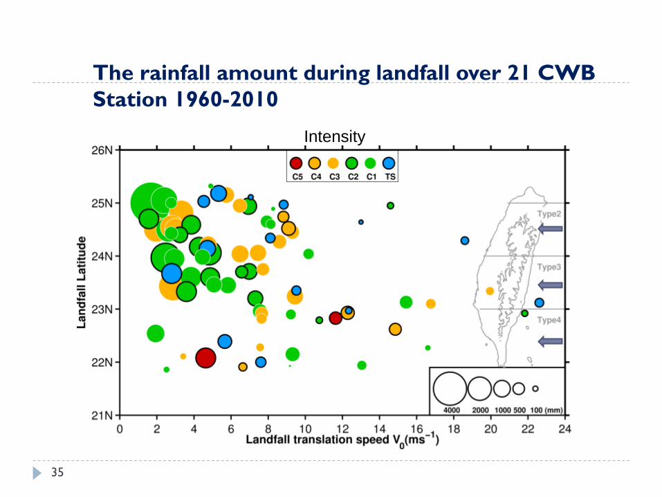
The rainfall amount during landfall over 21 CWB
Station 1960-2010
35
Intensity

100
50 150
(a) slow moving cases (b) medium moving cases
Li-Huan Hsu
1960-2010
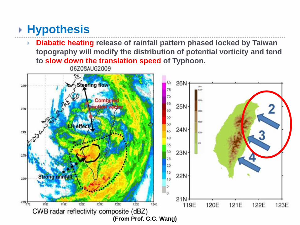
Hypothesis Diabatic heating release of rainfall pattern phased locked by Taiwan
topography will modify the distribution of potential vorticity and tend
to slow down the translation speed of Typhoon.
(From Prof. C.C. Wang)
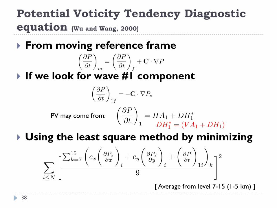
Potential Voticity Tendency Diagnostic
equation (Wu and Wang, 2000)
From moving reference frame
If we look for wave #1 component
Using the least square method by minimizing
PV may come from:
[ Average from level 7-15 (1-5 km) ]
38
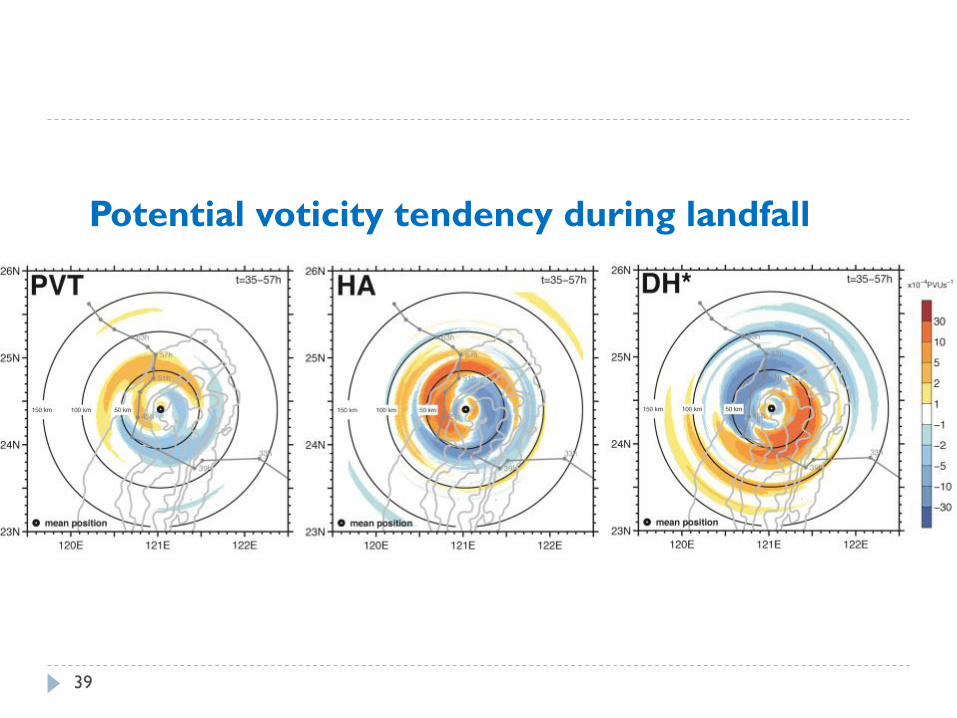
Potential voticity tendency during landfall
39
rt=0.2Rm
τ=2.6hr
τ
τ
τ
τ
τ
τ
4τ
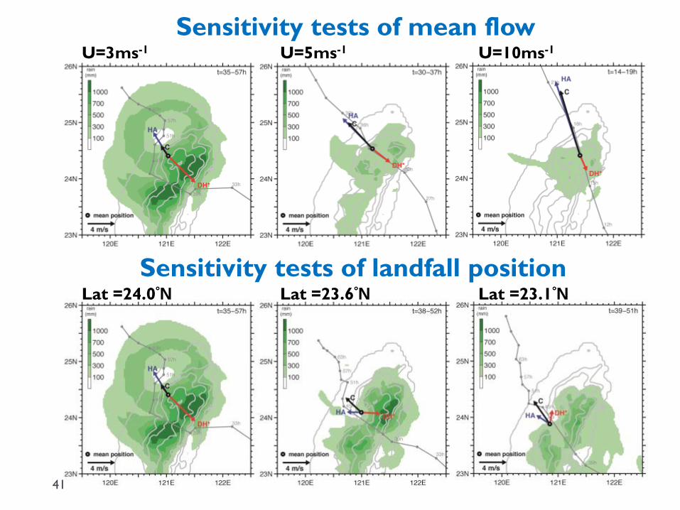
Sensitivity tests of mean flow
Sensitivity tests of landfall position
U=3ms-1 U=5ms-1 U=10ms-1
Lat =24.0°N Lat =23.6°N Lat =23.1°N
41
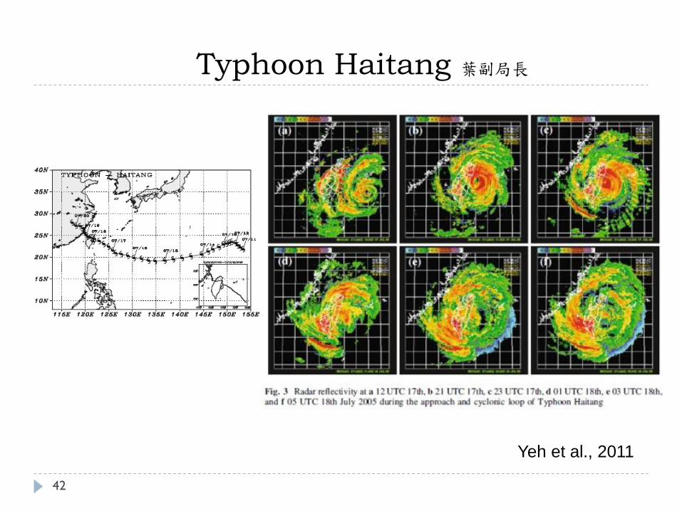
Typhoon Haitang 葉副局長
42
Yeh et al., 2011
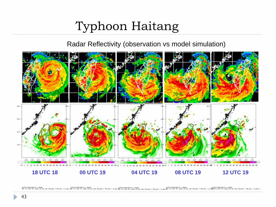
Typhoon Haitang
18 UTC 18 00 UTC 19 04 UTC 19 08 UTC 19 12 UTC 19
Radar Reflectivity (observation vs model simulation)
43
Typhoon Haitang
44
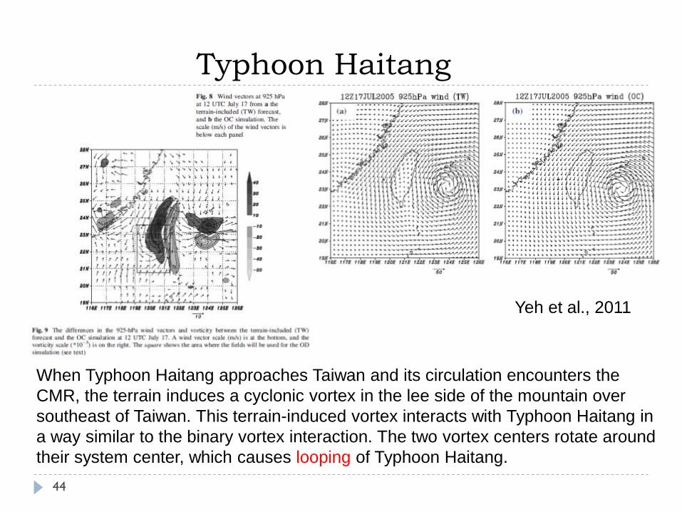
When Typhoon Haitang approaches Taiwan and its circulation encounters the
CMR, the terrain induces a cyclonic vortex in the lee side of the mountain over
southeast of Taiwan. This terrain-induced vortex interacts with Typhoon Haitang in
a way similar to the binary vortex interaction. The two vortex centers rotate around
their system center, which causes looping of Typhoon Haitang.
Yeh et al., 2011
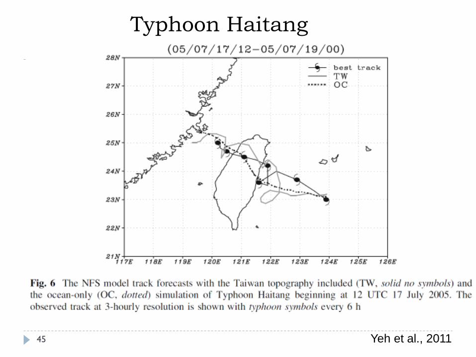
Typhoon Haitang
45 Yeh et al., 2011
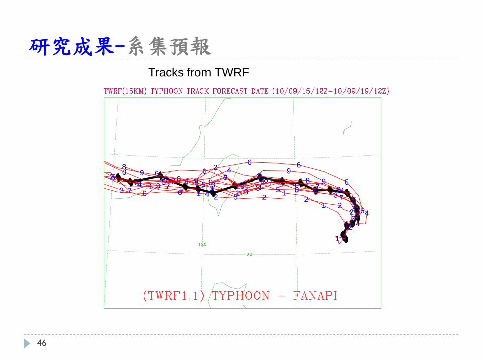
研究成果-系集預報
1 1
1
1
11
2
22
222
3
3
3333
4
4
444
4
5
555
5
5
6
6
66
66
7
77
7
7
78
8888
8
9
9
99
9
9
0000
0
0
1
111
1
1
22
222
2
333
3
3
3
4
444
44
555
555
666
6
66
77
7
7
77
Tracks from TWRF
46
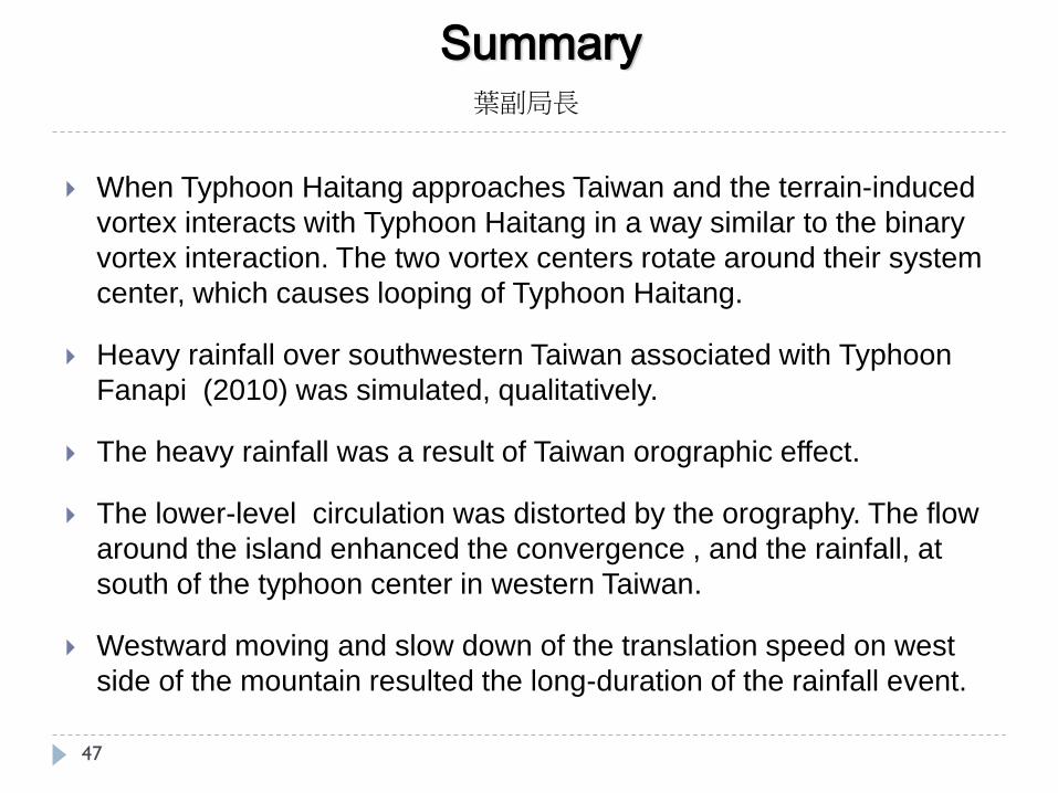
Summary
When Typhoon Haitang approaches Taiwan and the terrain-induced
vortex interacts with Typhoon Haitang in a way similar to the binary
vortex interaction. The two vortex centers rotate around their system
center, which causes looping of Typhoon Haitang.
Heavy rainfall over southwestern Taiwan associated with Typhoon
Fanapi (2010) was simulated, qualitatively.
The heavy rainfall was a result of Taiwan orographic effect.
The lower-level circulation was distorted by the orography. The flow
around the island enhanced the convergence , and the rainfall, at
south of the typhoon center in western Taiwan.
Westward moving and slow down of the translation speed on west
side of the mountain resulted the long-duration of the rainfall event.
47
葉副局長
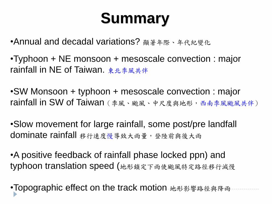
Summary
•Annual and decadal variations? 顯著年際、年代紀變化
•Typhoon + NE monsoon + mesoscale convection : major
rainfall in NE of Taiwan. 東北季風共伴
•SW Monsoon + typhoon + mesoscale convection : major
rainfall in SW of Taiwan(季風、颱風、中尺度與地形,西南季風颱風共伴)
•Slow movement for large rainfall, some post/pre landfall
dominate rainfall 移行速度慢導致大雨量,登陸前與後大雨
•A positive feedback of rainfall phase locked ppn) and
typhoon translation speed (地形鎖定下雨使颱風特定路徑移行減慢
•Topographic effect on the track motion 地形影響路徑與降雨
小結-路徑異常變化物理機制研究
颱風與季風的交互作用;東北季風共伴(Megi 2010), 西南氣流共伴(Morakot 2009)
颱風及夏季降雨造成之極端降雨佔台灣地區極端降雨個案之75%,累積雨量與整體極端降雨累積雨量的相關性達到0.93。
1995年以後颱風的極端降雨量有顯著的上升,分成1960-1976、1977-1993、1994-2010年極端降雨的累積雨量呈現年代際變化(Decadal Variations)。
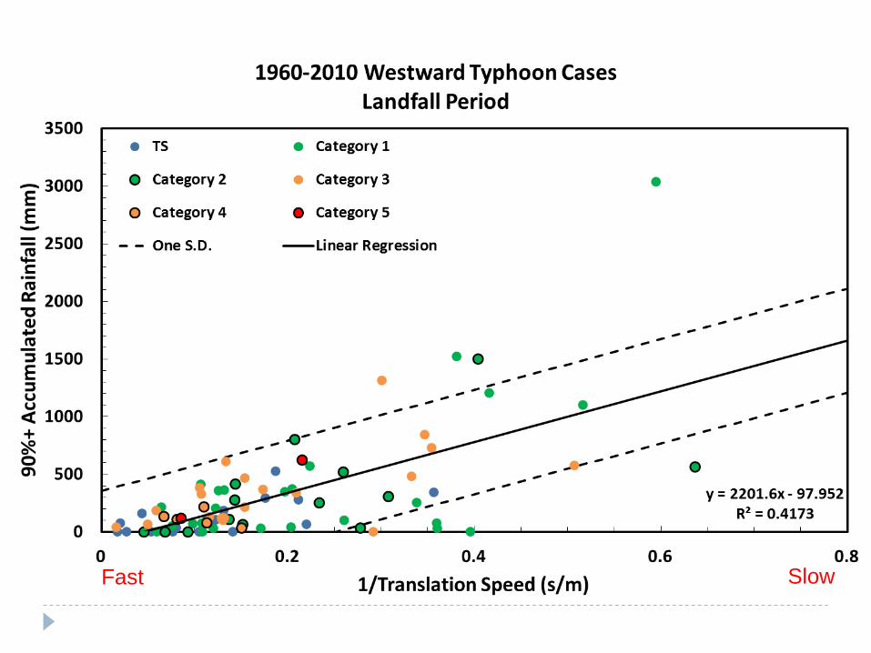
颱風登陸期極端降雨和颱風強度並無明顯的關係,但是與颱風移速成反比。其相關性雖不如颱風登陸期累積雨量與颱風移速的關係來的好,但也達中度相關。
49
小結-路徑異常變化物理機制研究
雨量大個案在陸期間移速較慢且登陸位置較北邊,多為中央氣象局路徑2與路徑3之颱風。
颱風移速較慢個案的在臺灣登陸期間的累積雨量要比中等移速個案大2.8倍(中等移速個案平均移速為慢移速個案的2.6倍)
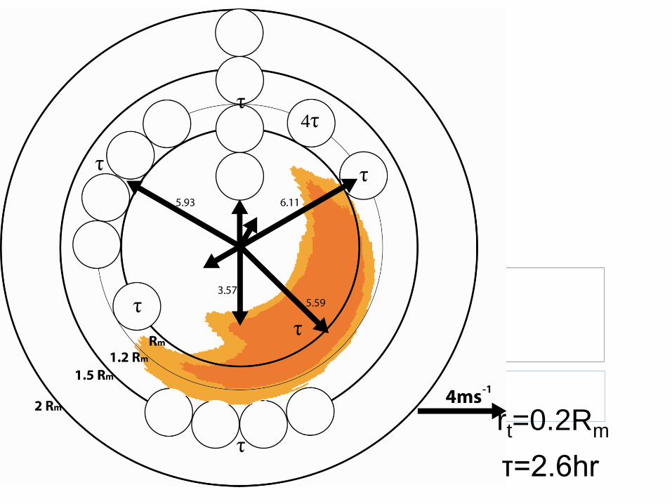
以位渦趨勢診斷方法探討降雨潛熱釋放對颱風運動之影響。降雨極值分布相對颱風中心位置,會產生正的位渦趨勢,使路徑2與路徑3之颱風減慢。
透過敏感度測試,移速慢、登陸位置北邊之颱風在陸期間有較大之累積雨量,降雨造成潛熱釋放所得之位渦趨勢也較大。
50
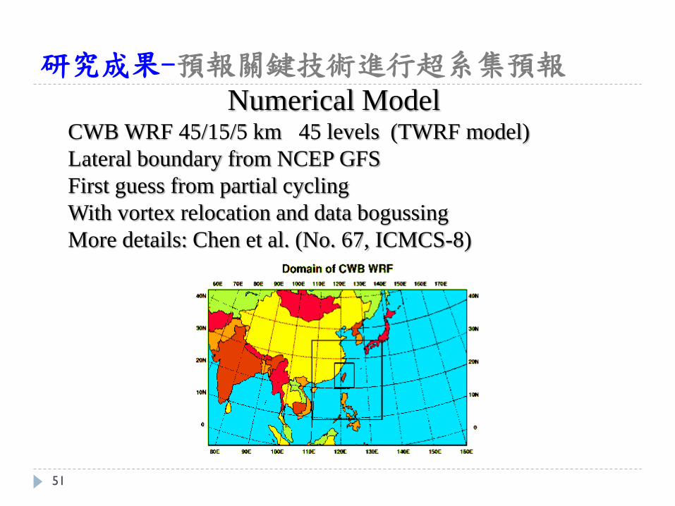
研究成果-預報關鍵技術進行超系集預報
Numerical Model CWB WRF 45/15/5 km 45 levels (TWRF model)
Lateral boundary from NCEP GFS
First guess from partial cycling
With vortex relocation and data bogussing
More details: Chen et al. (No. 67, ICMCS-8)
51
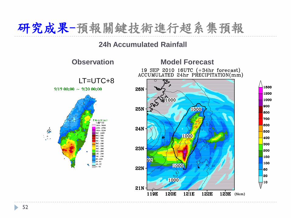
研究成果-預報關鍵技術進行超系集預報
24h Accumulated Rainfall
Observation Model Forecast
LT=UTC+8
52
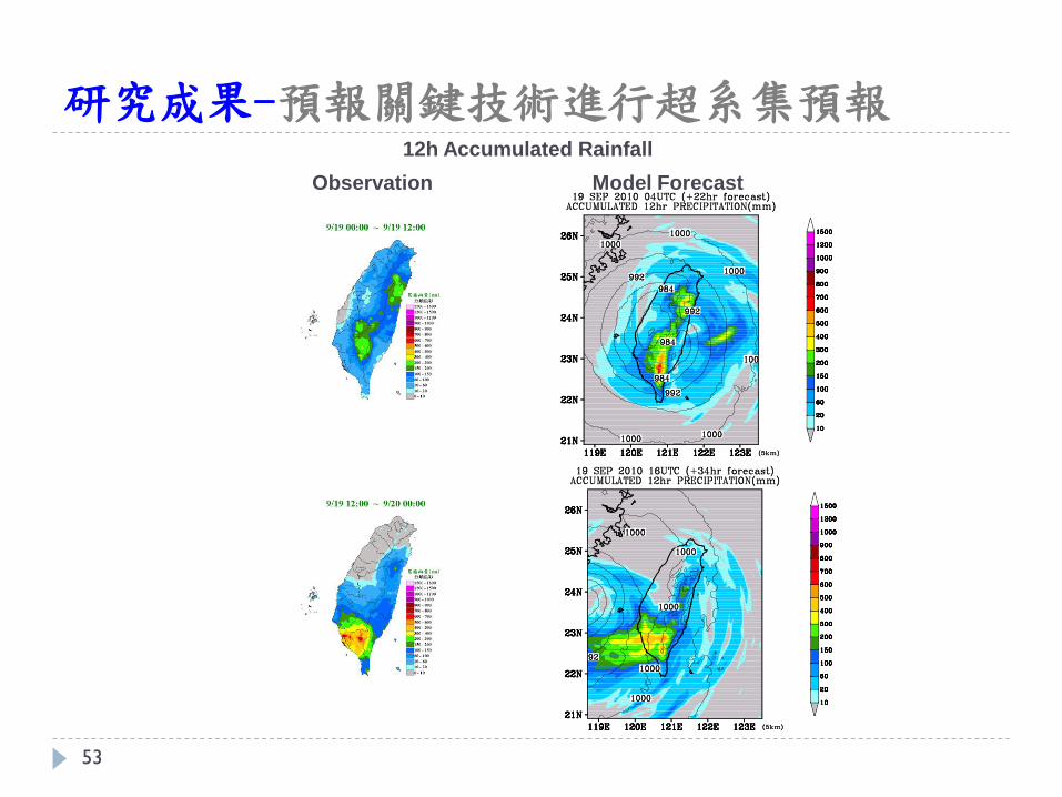
研究成果-預報關鍵技術進行超系集預報 12h Accumulated Rainfall
Observation Model Forecast
53
研究成果-預報關鍵技術進行超系集預報
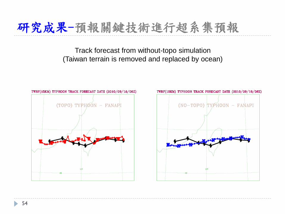
Track forecast from without-topo simulation
(Taiwan terrain is removed and replaced by ocean)
54
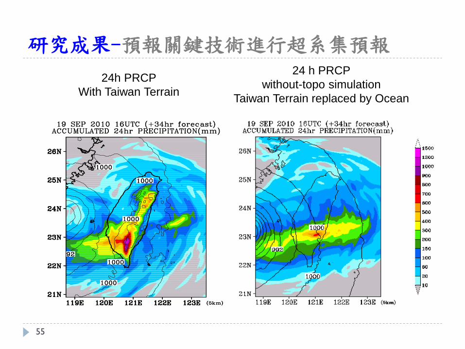
研究成果-預報關鍵技術進行超系集預報 24 h PRCP
without-topo simulation
Taiwan Terrain replaced by Ocean
24h PRCP
With Taiwan Terrain
55
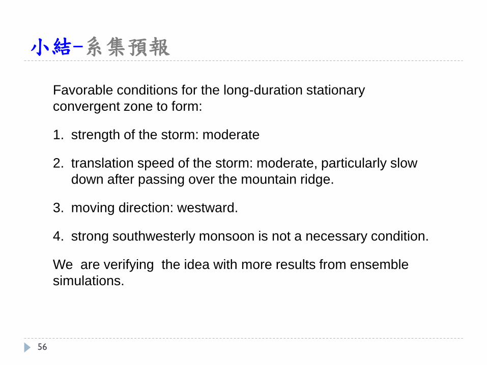
小結-系集預報
Favorable conditions for the long-duration stationary
convergent zone to form:
1. strength of the storm: moderate
2. translation speed of the storm: moderate, particularly slow
down after passing over the mountain ridge.
3. moving direction: westward.
4. strong southwesterly monsoon is not a necessary condition.
We are verifying the idea with more results from ensemble
simulations.
56
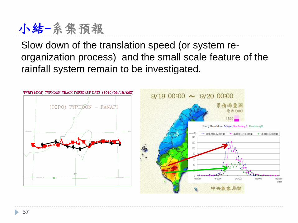
小結-系集預報
Slow down of the translation speed (or system re-
organization process) and the small scale feature of the
rainfall system remain to be investigated.
57
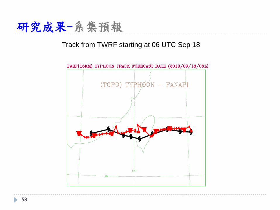
研究成果-系集預報
Track from TWRF starting at 06 UTC Sep 18
58

95% + Extreme Rainfall
Typhoon Accumulated Rainfall Decadal
59
60
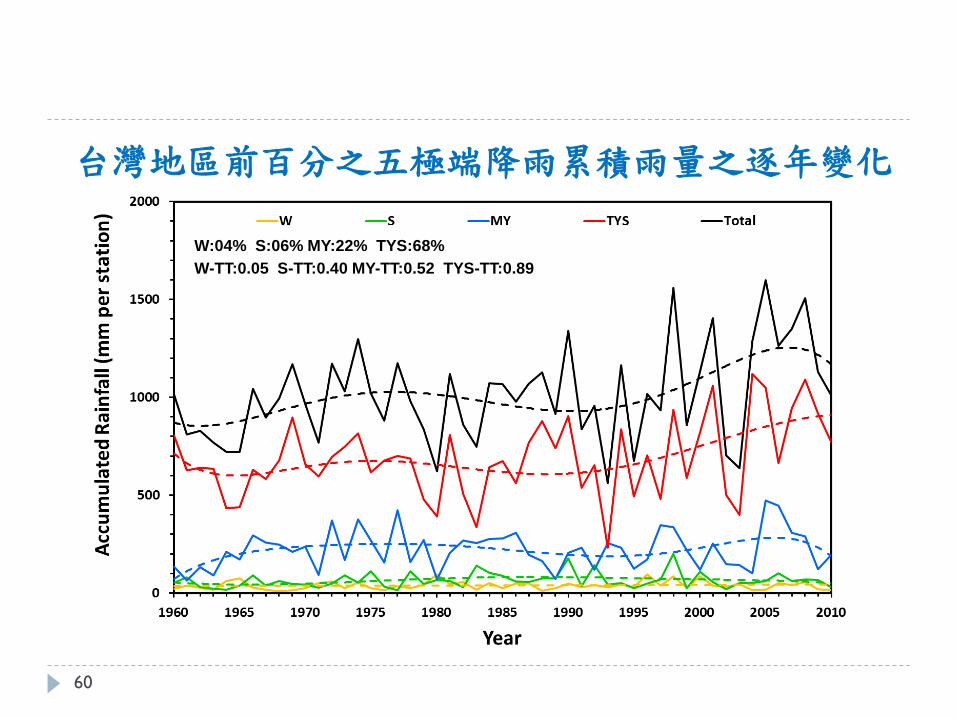
W:04% S:06% MY:22% TYS:68%
W-TT:0.05 S-TT:0.40 MY-TT:0.52 TYS-TT:0.89
台灣地區前百分之五極端降雨累積雨量之逐年變化
61
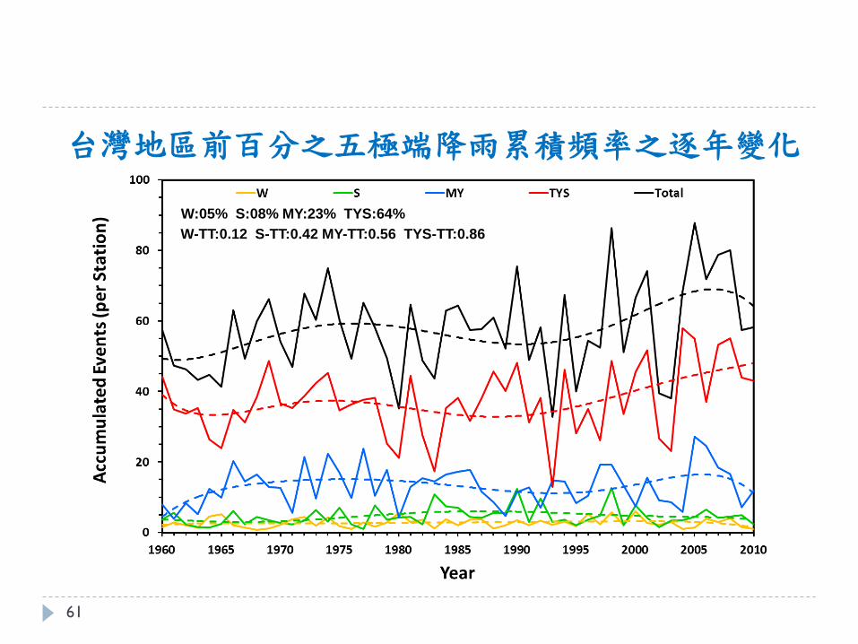
台灣地區前百分之五極端降雨累積頻率之逐年變化
W:05% S:08% MY:23% TYS:64%
W-TT:0.12 S-TT:0.42 MY-TT:0.56 TYS-TT:0.86