UC Drought Response Report to the Office of Governor Edmund G ...

FIRST REPORT TO THE GOVERNOR AND THE GENERAL ASSEMBLY
Regarding progress of the DELAWARE SOURCE WATER ASSESSMENT AND PROTECTION PROGRAMJune, 2004
Prepared by the:
Department of Natural Resources and Environmental Control and the Source Water Protection Citizen and Technical Advisory Committee

1
Table of Contents
I. Introduction ………………………………………………………………. 2
II. Delaware’s Source Water Protection Program ………………………… 2
III. Delaware Source Water Protection Citizens and Technical Advisory Committee ………………………………………………………………… 3
IV. Status of Source Water Assessments in Delaware ……………………… 5
V. Status of Ground-Water Recharge Mapping …………………………… 7
VI. Potential Sources of Contamination to Sources of Public Drinking Water …………………………………………………………… 8
VII. Summary and Status of Source Water Program Funded Projects ……. 12
VIII. Actions for Future Protection of Sources of Public Drinking Water ….. 15
References …………………………………………………………………………. 17
Figures ……………………………………………………………………………... 18
(Report is available on-line at www.wr.udel.edu/swaphome/)
2
Report to Governor Ruth Ann Minner and the Delaware General Assembly Delaware Source Water Assessment and Protection Program
June 2004
I. Introduction
The citizens of Delaware draw drinking water from either surface water streams or various underground aquifers. Streams with sufficient freshwater flow for these uses are found only in northern New Castle County but extend into southeastern Pennsylvania and northeastern Maryland. In the remainder of the state, a series of underground aquifers are the only available source of freshwater for drinking. All water in these aquifers originates from rainfall on the land surface, often on lands close to the producing well.
Surface water streams are vulnerable to contamination from releases into the stream or its tributaries or from discharge of ground water that serves as base flow to the stream. Some of the underlying aquifers are also vulnerable, particularly those closest to the land surface. The critical areas that provide the source water to these stream intakes or wells are termed watersheds or wellhead protection areas, respectively. These critical watersheds and wellhead areas are collectively termed “source water areas”. The most critical and vulnerable areas that provide recharge to the aquifers have also been mapped and are termed excellent ground-water recharge areas. The Delaware Source Water Assessment and Protection Program was created to focus state efforts on the protection of these critical areas in order to maintain high quality and adequate quantity of the water.
This report to the Governor and General Assembly on the status of source water protection efforts has been prepared per the requirements of Delaware Code Chapter 60 Section 6081. Both the status of the assessments of the source water areas and the efforts to establish protection measures are included in this report.
II. Delaware’s Source Water Protection Program
All states are required by the 1996 amendments to the federal Safe Drinking Water Act to conduct source water assessments and provide for public involvement in the assessment process. Thus, in 1997 DNREC requested participation from the public in what is now the Delaware Source Water Protection Citizen and Technical Advisory Committee whose role is to advise DNREC on the development and implementation of the source water program. In 2001, per the Delaware Source Water Protection law, Delaware’s General Assembly added membership to the committee, expanded its role, and designated source water protection areas, wellhead protection areas, and excellent ground-water recharge areas as critical areas.
Since October 1999 when the U.S. EPA approved the Delaware Source Water Assessment Plan, DNREC has been taking steps to complete the assessment of the source areas around all public supply wells and public surface water intakes. The Delaware plan calls for completing assessments for all of the approximately 520 water systems. The Delaware Division of Public Health (DPH) classifies public water

3
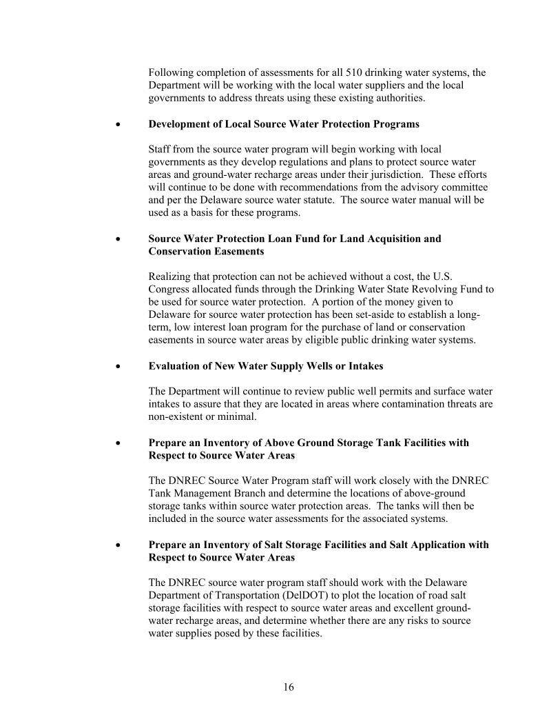
supply systems into three types – community, non-transient non community, and transient non-community. DNREC is assessing all of these beginning with the highest priority community systems. Almost all of the 228 community systems were completed in 2003. The remaining systems are currently being assessed and will be completed in 2004. Figure 1 illustrates the general locations for the approximately 1,000 public supply wells and the 5 surface water intakes.
Conducting the assessments requires mapping of the source water areas, identifying possible sources of contamination including land use categories within the source water areas, and evaluating the likelihood of contamination from these potential contaminant sources (termed susceptibility). Assessment reports are prepared for each water supply system and, following review and comment by the system owners or operators, are finalized. Copies of these reports are provided to the water system owners and are also available at the DNREC offices, DPH offices, and on the Delaware source water web site. The water systems are required to include the assessment findings in their consumer confidence reports. These reports are prepared annually by the water system purveyors and are provided to the customers.
In addition, the Department has begun to analyze the findings from all of the assessments. The results of this analysis will help identify the more pressing challenges within the source water areas. For instance, the largest numbers of potential point sources of contamination in source water areas are underground storage tank facilities, hazardous waste generators, unregulated hazardous waste sites, septic systems, and animal feedlot operations. The major land uses, which differ somewhat between the three counties, include crop, residential, combined urban, commercial, and forest lands. A few new classes of threats to sources of drinking water were identified and will be included in assessment updates, namely above- ground storage tanks and salt storage facilities.
Source water scientists will be working with staff from other programs to prioritize actions at problem facilities and to promote the use of best management practices for unregulated sites or land uses that could pose a threat to drinking water sources. Program staff will also be working with counties and large municipalities to implement protection measures and to prepare updates to their respective comprehensive land use plans. In addition, the Department will continue to work with water suppliers interested in obtaining loans for the purchase of land or conservation easements aimed at the long-term protection of sources of public drinking water.
III. Delaware Source Water Protection Citizen and Technical Advisory Committee
The Delaware Source Water Protection Citizen and Technical Advisory Committee was established in 1998 to advise DNREC in its preparation of the Delaware Source Water Assessment Plan. The Delaware committee was comprised of both citizen groups and technical groups. Following the committee’s concurrence, the source water plan was provided to the U.S. EPA for their approval. At that time the committee elected to remain in existence to further advise DNREC in the

4
management and implementation of the source water program and the preparation of the assessments. In 2001 the Delaware General Assembly passed the source water protection law which, among other things, made the advisory committee permanent and expanded its membership. Table 1 contains the representatives on the Delaware Source Water Protection Citizen and Technical Advisory Committee.
Table 1. Delaware Source Water Citizen and Technical Advisory Committee
Name Affiliation Status Mr. Joseph Demul AARP Citizen Mr. Lloyd Hughes AARP Citizen Vacant Delaware Public Health Association Citizen Mr. Kenneth Wicks Council of Farm Organizations Citizen Dr. William Guertal United States Geological Survey TechnicalMr. Tad Yancheski Tetra Tech, Inc. / Committee of 100 Technical Mr. Anthony Joering Duffield Associates / Committee of 100 Citizen/TechnicalMrs. Dawn Cook United Water Delaware TechnicalMr. Scott Koenig City of Dover TechnicalMr. Gilbert Holt Town of Lewes Board of Public Works Technical Mr. Joseph DiNunzio Artesian Water Company TechnicalMs. Nancy Parker Artesian Water Company Citizen Ms. Sheila Dolan Tidewater Utilities TechnicalMs. Colleen Arnold City of Wilmington TechnicalMr. Kent A. Bacon Culligan Water Conditioning Technical Mr. Anthony Gersitz American Water Works Association TechnicalMr. Jigar Patel Delaware Rural Water Association TechnicalMr. Vince Winkler Delaware Farm Bureau CitizenMs. Til Purnell League of Women Voters/ Friends of Herring Creek CitizenMrs. Marion Stewart Civic League for New Castle County Citizen Ms. Lorraine Fleming Christina Conservancy Citizen Ms. Lori Spagnolo Delaware Nature Society Citizen/TechnicalMr. John Flaherty Greenwatch Institute Citizen Mr. Scott Blaier Department of Agriculture TechnicalMs. Anita Beckel Division of Public Health Technical Mr. John Talley Delaware Gelogical Survey TechnicalMr. Jerry Kauffman Water Resources Agency Technical Mr. Martin Wollaston Water Resources Agency Technical Mr. George Haggerty New Castle County Dept. of Land Use TechnicalMr. John Barndt DNREC, Source Water Protection TechnicalMr. Stephen Williams DNREC, Whole Basin Management TechnicalMr. Hassan Mirsajadi DNREC, Watershed Assessment Technical Mr. Alex Rittberg DNREC, Air and Waste Management TechnicalMr. Paul Jones Delaware Association of Professional Engineers TechnicalMr. Stephen Lefebvre Homebuilders Association of Delaware Citizen Mr. Robert Wittig Commercial & Industrial Realty Council Citizen/TechnicalMr. B.J. Hardin Sussex County Association of Towns Citizen Mr. George Wright Delaware League of Local Governments CitizenMr. Donald Blakey, PhD Kent County Levy Court CitizenMr. Dale Dukes Sussex County Council CitizenMs. Joy Sikora American Association of University Women/ Inter-
Group Council Citizen
Alternates
Mr. Bill Powers Delaware Farm Bureau CitizenMr. Scott Andres Delaware Geological Survey Technical Mr. Edward Hallock Division of Public Health Technical
5
The committee has advised DNREC on source water plan modifications, release of sensitive information from the assessment reports, special source water funded projects, development of the source water best management practices manual, and other matters related to source water assessment and protection. Delaware is unique among neighboring states in retaining the enthusiastic cooperation and involvement of its advisory committee.
The source water committee meets quarterly at the Public Safety Conference Room, Dover. Minutes and other announcement of committee meetings are found on the Source Water Protection web site at http://www.wr.udel.edu/swaphome/index.html.
IV. Status of Source Water Assessments in Delaware
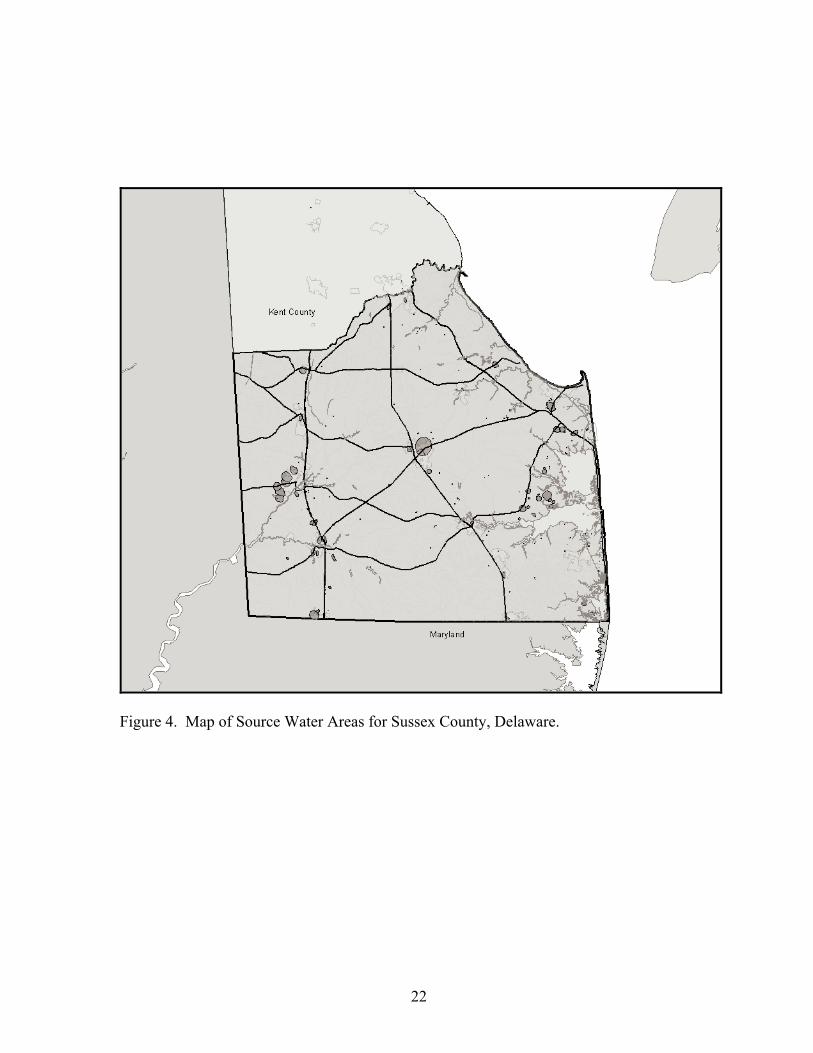
Source water assessments consist of four major components. First, the most critical area around public water supply wells or surface water intakes is mapped. These are termed wellhead protection areas around supply wells and surface water assessment areas upstream of surface water intakes. Figures 2, 3, and 4 show the source water areas for the three counties. Second, the existing or potential contaminant threats found within these areas are located and placed on maps. Third, an assessment is made based on the vulnerability of the water source and the threat posed by the sources of contamination. This is the heart of the source water assessment and looks at both discrete sources and land use types. Fourth, the assessment is made available to the water supply owner and the public both in hard copy and on the Delaware Source Water Protection web site.
There are three classes of public water supply systems, as defined by the Delaware Division of Public Health, which are addressed by the source water protection program. These include the community systems (e.g. municipalities, large water suppliers, manufactured home parks), non-transient non-community systems (schools, businesses, day cares), and transient non-community systems (restaurants, recreational parks). It is the community systems that provide water to permanent customers around the clock and, therefore, have been a priority. These community systems provide water to the majority of Delaware citizens who are customers of the community public water supply systems.
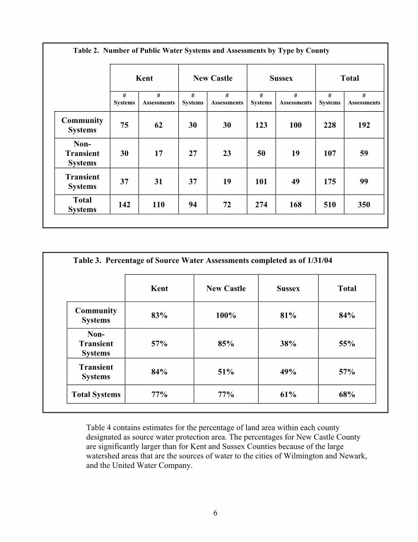
Of the approximately 510 public water supply systems in Delaware, 350 assessments have been completed and most of those remaining will be completed in 2004. Table 2 summarizes the status of these assessments and Table 3 describes the relative progress in completing these assessments.
6
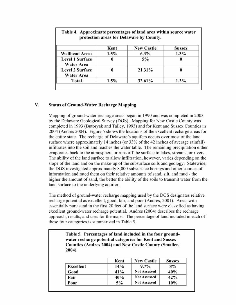
Table 4 contains estimates for the percentage of land area within each county designated as source water protection area. The percentages for New Castle County are significantly larger than for Kent and Sussex Counties because of the large watershed areas that are the sources of water to the cities of Wilmington and Newark, and the United Water Company.
Table 2. Number of Public Water Systems and Assessments by Type by County
Kent New Castle Sussex Total
#Systems
#Assessments
#Systems
#Assessments
#Systems
#Assessments
#Systems
#Assessments
Community Systems 75 62 30 30 123 100 228 192
Non-TransientSystems
30 17 27 23 50 19 107 59
TransientSystems 37 31 37 19 101 49 175 99
TotalSystems 142 110 94 72 274 168 510 350
Table 3. Percentage of Source Water Assessments completed as of 1/31/04
Kent New Castle Sussex Total
Community Systems 83% 100% 81% 84%
Non-TransientSystems
57% 85% 38% 55%
TransientSystems 84% 51% 49% 57%
Total Systems 77% 77% 61% 68%
7
V. Status of Ground-Water Recharge Mapping
Mapping of ground-water recharge areas began in 1990 and was completed in 2003 by the Delaware Geological Survey (DGS). Mapping for New Castle County was completed in 1993 (Butoryak and Talley, 1993) and for Kent and Sussex Counties in 2004 (Andres 2004). Figure 5 shows the locations of the excellent recharge areas for the entire state. The recharge of Delaware’s aquifers occurs over most of the land surface where approximately 14 inches (or 33% of the 42 inches of average rainfall) infiltrates into the soil and reaches the water table. The remaining precipitation either evaporates back to the atmosphere or runs off the surface to lakes, streams, or rivers. The ability of the land surface to allow infiltration, however, varies depending on the slope of the land and on the make-up of the subsurface soils and geology. Statewide, the DGS investigated approximately 8,000 subsurface borings and other sources of information and rated them on their relative amounts of sand, silt, and mud - the higher the amount of sand, the better the ability of the soils to transmit water from the land surface to the underlying aquifer.
The method of ground-water recharge mapping used by the DGS designates relative recharge potential as excellent, good, fair, and poor (Andres, 2001). Areas with essentially pure sand in the first 20 feet of the land surface were classified as having excellent ground-water recharge potential. Andres (2004) describes the recharge approach, results, and uses for the maps. The percentage of land included in each of these four categories is summarized in Table 5.
Table 5. Percentages of land included in the four ground-water recharge potential categories for Kent and Sussex Counties (Andres 2004) and New Castle County (Smailer, 2004)
Kent New Castle Sussex Excellent 14% 9.7% 8% Good 41% Not Assessed 40% Fair 40% Not Assessed 42% Poor 5% Not Assessed 10%
Table 4. Approximate percentages of land area within source water protection areas for Delaware by County.
Kent New Castle Sussex Wellhead Areas 1.5% 6.3% 1.3% Level 1 Surface
Water Area 0 5% 0
Level 2 Surface Water Area
0 21.31% 0
Total 1.5% 32.61% 1.3%

8
The excellent ground-water recharge potential areas were included in Delaware Code Chapter 60 Section 6081 and will require special protection by local governments. However, it should be noted that the other land areas also contribute vast amounts of recharge to the underlying aquifers.
VI. Potential Sources of Contamination to Sources of Public Drinking Water
There are a multitude of potential contaminant sources that, if present, could degrade drinking water quality. Most of these sources are anthropogenic; however, natural 'contaminants' such as salt water or iron deposits can also impact water supplies. Most human impacts occur at or just below the ground surface and, therefore, are a concern for shallow ground-water and surface water.
Discrete Sources Discrete sources are defined as existing or potential sources of pollution to surface or ground-water supplies at well defined 'points' or locations. The source water program lists the discrete sources into the following categories:
Underground Storage Tanks Large On-Site Septic Landfills / Dumps Wastewater Spray Irrigation National Pollutant Discharge Elimination System. Waste Sludge ApplicationTire Piles Animal Feedlot Operations Hazardous Waste Generators Combined Sewer Overflows Toxic Release Inventory Dredge Spoils Salvage Yards Golf Courses Pesticide Loading, Mixing, & Storage Facility Domestic Septic Systems State and Federal Superfund Sites
These discrete sources can contaminate source water depending upon their location, the severity of a release, and other factors. For example, golf courses may contribute both pesticides and nutrients to the surface and ground waters by means of surface application for landscaping purposes, whereas tire piles generally do not pose a threat to water unless they catch fire and, then, release toxic compounds that contaminate air, soils and water.
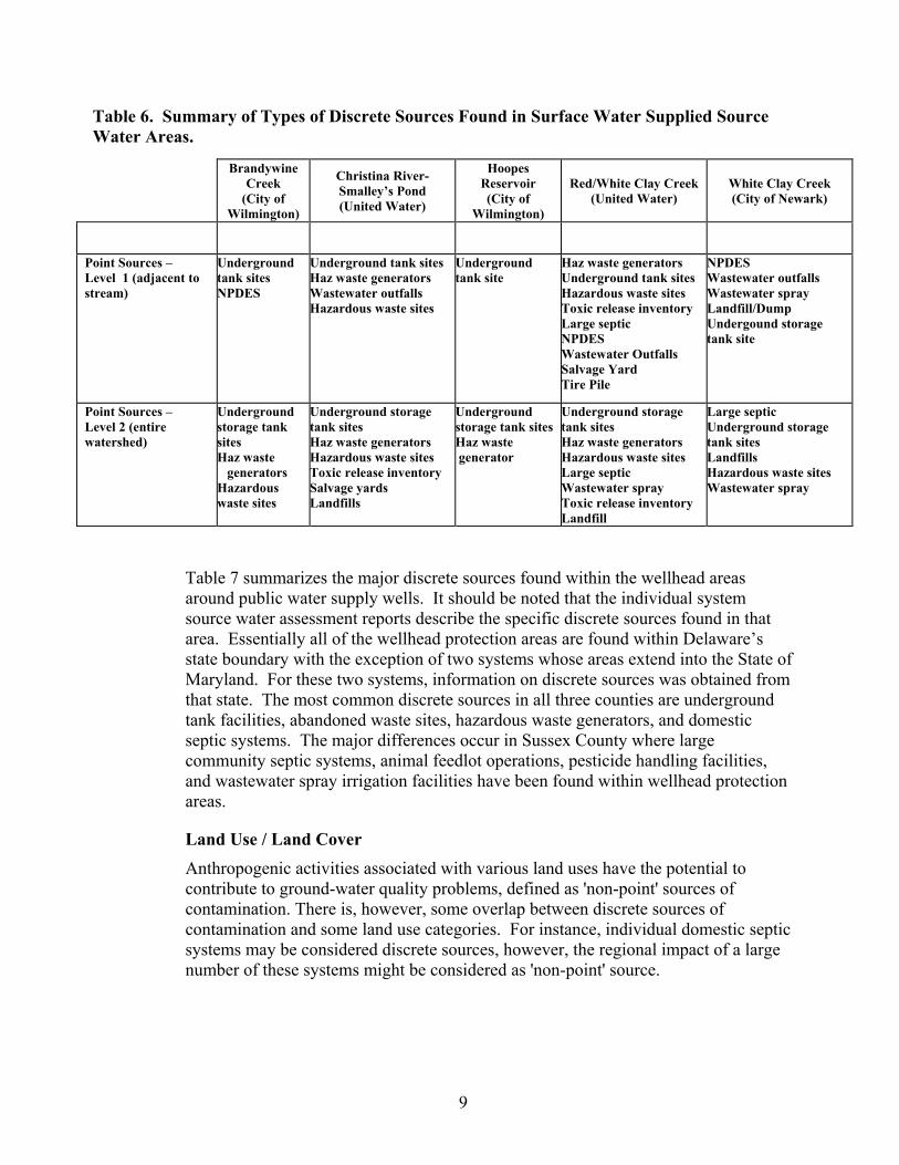
Table 6 summarizes the major discrete sources found within the source water watersheds of northern Delaware. These watersheds extend into southeastern Pennsylvania with a small area found in northeastern Maryland. The availability of information from the various states differed with the more complete information available in Delaware due to Delaware’s whole basin assessments. These watersheds are divided into two “levels” of concern. Level 1 refers to those areas immediately adjacent to the stream. The most common discrete sources in these areas were underground tank facilities, hazardous waste generators, wastewater outfalls, and an assortment of others. Level 2 refers to the remaining land area within the watersheds, more removed from the stream itself. The most common discrete sources found were very similar to those found in the Level 1 areas.
9
Table 6. Summary of Types of Discrete Sources Found in Surface Water Supplied Source Water Areas.
Table 7 summarizes the major discrete sources found within the wellhead areas around public water supply wells. It should be noted that the individual system source water assessment reports describe the specific discrete sources found in that area. Essentially all of the wellhead protection areas are found within Delaware’s state boundary with the exception of two systems whose areas extend into the State of Maryland. For these two systems, information on discrete sources was obtained from that state. The most common discrete sources in all three counties are underground tank facilities, abandoned waste sites, hazardous waste generators, and domestic septic systems. The major differences occur in Sussex County where large community septic systems, animal feedlot operations, pesticide handling facilities, and wastewater spray irrigation facilities have been found within wellhead protection areas.
Land Use / Land Cover Anthropogenic activities associated with various land uses have the potential to contribute to ground-water quality problems, defined as 'non-point' sources of contamination. There is, however, some overlap between discrete sources of contamination and some land use categories. For instance, individual domestic septic systems may be considered discrete sources, however, the regional impact of a large number of these systems might be considered as 'non-point' source.
Brandywine Creek
(City of Wilmington)
Christina River-Smalley’s Pond (United Water)
HoopesReservoir (City of
Wilmington)
Red/White Clay Creek (United Water)
White Clay Creek (City of Newark)
Point Sources – Level 1 (adjacent to stream)
Underground tank sites NPDES
Underground tank sites Haz waste generators Wastewater outfalls Hazardous waste sites
Underground tank site
Haz waste generators Underground tank sites Hazardous waste sites Toxic release inventory Large septic NPDES Wastewater Outfalls Salvage Yard Tire Pile
NPDES Wastewater outfalls Wastewater spray Landfill/DumpUndergound storage tank site
Point Sources – Level 2 (entire watershed)
Underground storage tank sitesHaz waste generators
Hazardous waste sites
Underground storage tank sites Haz waste generators Hazardous waste sites Toxic release inventory Salvage yards Landfills
Underground storage tank sites Haz waste generator
Underground storage tank sites Haz waste generators Hazardous waste sites Large septic Wastewater spray Toxic release inventory Landfill
Large septic Underground storage tank sites LandfillsHazardous waste sites Wastewater spray

10
Table 8 summarizes the land use types within the watersheds upstream of the public water supply surface water intakes. It also summarizes the percentages of each watershed found within Delaware and adjacent states. Only the Hoopes Reservoir watershed is located entirely within the State of Delaware.In the cases of Brandywine Creek and White Clay Creek, at least 90% of the watershed is located in Pennsylvania. The watersheds (Brandywine Creek, White Clay Creek) with most of their land area in southern Pennsylvania have a high percentage of wooded or agricultural land use. The watersheds located largely in Delaware (Christina River, Red/White Clay Creek) have a higher percentage of residential and wooded land uses. The exception is the Hoopes Reservoir watershed which is mostly wooded.
Table 7. Summary of Types of Discrete Sources Found in Ground-Water Supplied Source Water Areas by County
New Castle Kent Sussex
CommunitySystems
Underground storage tank sites Haz waste generators Hazardous waste sites Toxic Release Inventory NPDES Domestic Septic
Underground storage tank sitesHazardous waste sites Haz Waste Generators NPDES Domestic Septic
Underground storage tank sitesHaz waste generators Hazardous waste sites Large septic Animal feedlot operations Pesticide loading, mixing, or storage NPDES Wastewater spray Domestic septic
Transient and Non-transient
Systems
Underground storage tank sites Hazardous Waste Sites Haz Waste Generators Domestic Septic
Underground storage tank sitesLarge Septic Domestic Septic
Underground storage tank sitesHazardous Waste Sites Animal Feedlot OperationDomestic Septic Haz Waste Generators NPDES

11
Table 8. Major land uses associated with surface water source water areas.
Brandywine Creek
(City of Wilmington)
ChristinaRiver-
Smalley’s Pond(United Water)
HoopesReservoir(City of
Wilmington)
Red/WhiteClay Creeks
(United Water)
While Clay Creek
(City of Newark)
%SWA in DE %SWA in Other States
8% - DE 92% - PA
77% - DE 17% - MD
100% – DE 0
42% - DE 58% - PA
10% - DE 90% - PA
ProminentLand Uses – Level 1 (adjacent to stream)
WoodedAgricultural Residential Public/Private Water
WoodedResidential Agricultural Public/Private
Wooded[Residential] [Agricultural]
WoodedResidential Agricultural Public/Private Commercial
WoodedAgricultural [Residential]
ProminentLand Uses – Level 2 (entire watershed)
Agricultural WoodedResidential [Public]
Residential WoodedAgricultural [Public/Private] [Industrial]
WoodedResidential [Agricultural] [Public/Private]
Agricultural Residential WoodedPublic/Private Institutional
Agricultural WoodedResidential
[ ] = minimal acreages of these land uses
Table 9 summarizes the major land use types within the wellhead protection areas around public water supply wells between the three counties. All major land uses are found with some differences in dominant types. System-specific assessments provide a more useful description of land use types.
Table 9. Major land uses associated with wellhead protection areas around public water supply wells.
New Castle Kent Sussex
CommunityPWS
Residential Cropland Commercial Combined Urban Forested
Cropland Residential WetlandsForested Commercial
Residential Cropland Combined urban Commercial Forested
Transientand Non-transient
PWS
Combined urban Residential RecreationalCommercial Forested
RecreationalCommercial Residential Cropland Forested
Cropland WetlandsResidential Forested Recreational

12
VII. Summary and Status of Source Water Program Funded Projects
A. Distribution of Selected Contaminants in Public Water Supplies in the Surficial Aquifer, Delaware - Completed
The U.S. Geological Survey, under contract to DNREC, completed a study of 30 randomly selected public water supply wells that draw water from the most vulnerable unconfined aquifer. These wells were sampled prior to any treatment by the water supplier and, therefore, represented ambient water quality within the aquifer at the time of sampling. These wells were tested for pesticides, pesticide daughter compounds (metabolites), volatile organic compounds, nutrients, and major inorganic compounds. A subset of 10 wells was also tested for radium and radon.
At least one pesticide or pesticide-metabolite was detected at low concentrations in most of the wells. At least one volatile organic compound was detected in every well, but at low levels. Neither the pesticides nor volatile organic compound detections violated any EPA drinking water standard or health advisory. Nitrate was detected in all but 4 of the 30 samples with one exceeding the EPA standard of 10 mg/L. Iron and manganese exceeded the secondary standard in 7 of the 30 samples. Radon was detected in all 10 wells with one exceeding the EPA drinking water standard. Radium was found in two of the 10 wells sampled, but at levels below drinking water standards. Both radium and radon are naturally-occurring elements that have been found in aquifers in adjacent states.
These results were shared with the individual system operators and, where needed, the Delaware Office of Drinking Water, to assure that violations of drinking water standards were addressed. The results demonstrated the long-term impacts of anthropogenic activities on water in the water-table aquifer, and hence its vulnerability. Since some of the wells had water over 20 years old, the quality reflects activities that occurred 20 years ago when that water first entered the aquifer as recharge from the land surface.
B. Lewes-Rehoboth Wellhead Protection Area Modeling - Completed
The Delaware Geological Survey, under contract to DNREC, used advanced ground-water modeling techniques to delineate the wellhead protection areas for the Lewes-Rehoboth Beach area which encompasses approximately 80 public water supply wells, numerous domestic wells, and other non-potable use wells such as commercial and irrigation. The larger public supply well fields for Lewes, Rehoboth Beach, and Tidewater Utilities were modeled (Andres, et al, 2003). The final report is available from the DGS and is also found on line at: http://www.udel.edu/dgs/Publications/pubform.html#investigations. These modeled wellhead protection areas have been used by the program in preparing the source water assessments for these systems.

13
C. Impact of Known or Suspected Contaminant Sources on Selected Public Drinking Water Supplies in Delaware – Completed
DNREC and DHSS cooperated to sample wells and post-treatment water from public water supply wells screened in the shallow unconfined aquifer and located near waste sites under investigation by the Delaware Superfund program. Pre- and post-treatment water samples were collected from 53 ground-water based systems and from 4 surface-water based systems. All samples were analyzed for volatile and semi-volatile organic compounds, metals, cyanide, pesticides, polychlorinated biphenyls, and nutrients.
Twenty water sources exceeded either the drinking water standard or the DNREC risk-based standard for raw untreated water. All of the finished or treated water met all applicable standards. Two systems that did not have treatment exceeded the drinking water standard for MTBE and both were referred to the Office of Drinking Water for corrective action. Most of the other detections in treated water were for disinfection by-products, but none exceeded standards.
Overall, the study found very few contaminants of concern. A few systems required some type of follow-up by the Department such as re-sampling to confirm the initial results, system treatment, or tie-in to an adjacent system. There will also be some further investigations by DNREC to identify the sources of contamination.
D. Manual for Source Water Protection – Final Draft
Delaware Code Chapter 60 Section 6081 required DNREC to develop a guidance manual to assist local counties and municipalities in their locally-developed plans and regulations to protect wellhead protection areas, ground-water recharge areas, and source water protection areas. DNREC developed a draft of this manual which received the concurrence of the Source Water Protection Citizen and Technical Advisory Committee at its March 2004 meeting. The Department also held additional meetings with other interested parties as requested and is considering their comments.
The focus of the manual is to provide information to local governments relevant to the protection of sources of drinking water that would be under their jurisdiction. The manual includes a summary of enabling legislation, recommended source water practices (e.g. zoning strategies, sediment and erosion control, urban practices, partnerships, funding options, and sample ordinances). It also includes two supplements that address ground-water recharge design methods, and Delaware conservation practices standards. The manual does not address state or federal programs that provide for protection of sources of drinking water under various jurisdictions and authorities.
The final manual will be published in the summer of 2004.
14
E. Technology Enabled Permitting Project - Well Database Migration – On-going
The Department’s water wells and septic system databases are being migrated from a largely DNREC-restricted database to an internet accessible database.This project is a component of a larger effort by DNREC, under the Environmental Information System initiative, to provide information to the public and to allow basic information to be readily updated.
F. Long Neck Area Mercury Study – On-going
The U.S. Geological Survey and the Delaware Geological Survey, under contract to DNREC, are investigating the extent and possible sources for mercury in ground water in the Long Neck area of Sussex County. This is potentially a multi-year effort prompted by the detection of mercury in a few public water supplies in the area. The project currently involves in-depth sampling of wells in the area and the installation and sampling of monitoring wells. Preliminary data are expected in late summer 2004. Periodic updates on the status of the investigation are provided to the source water advisory committee.
G. Ground Water Availability in Kent County – On-going
The U.S. Geological Survey and the Delaware Geological Survey, under contract to DNREC, are updating the ground-water availability reports for Kent County which were originally prepared in the early 1970s. The USGS is researching and updating aquifer and water-use information while the DGS is drilling test wells in areas of the county where geologic information is lacking. This project is scheduled to be completed in October 2004.
H. Hydrogeologic Assessment Project for Eastern Sussex County – On-going
The Delaware Geological Survey, under contract to DNREC, is updating basic hydrogeological information, to be made available in digital form, for the watersheds of eastern Sussex County. This information will update similar information on ground-water availability for this area prepared in the early 1970s. This project is scheduled to be completed by October 2004.
I. Source Water Program Web Site – On-going
Delaware’s source water web site is housed at the University of Delaware where it is maintained by Water Resources Agency for DNREC. It is found at http://www.wr.udel.edu/swaphome/index.html.
The web site contains historical information on the development of the source water assessment and protection program, final source water assessments, guidance documents, published research papers, and information on the
15
Citizens and Technical Advisory Committee including membership, meeting summaries, and meeting schedule.
J. EPA Polygon and Data Reporting Project - Completed
Delaware’s Source Water Protection Program was chosen as one of three programs nationally (with Connecticut and Minnesota) to participate in a pilot project by the USEPA and the Ground Water Protection Council on data reporting to the EPA. The purpose of the project was to determine if databases used by the state source water programs could have their data extracted and imported into the Drinking Water portion of the EPA’s Watershed Assessment, Tracking and Environmental Results (WATERS) database. This will allow the EPA to look at the extent of source water protection activities on a national scale and to determine where, with respect to contaminants and source susceptibility, more detailed study needs to take place. Data were provided to the EPA contractor in mid-March 2004 and a report on their findings is due the 3rd quarter 2004.
From September 2003 through December 2003 the DNREC also cooperated with US EPA Headquarters personnel to supply GIS polygon layers of the source water protection areas (in Delaware) that had been completed to date. The purpose of this was for the EPA to track their goal of having 50% of the public drinking water systems with completed source water assessments by 2005. At the time of data submittal, over 60% of Delaware’s population using public drinking water systems had completed source water assessments.
K. Arsenic in Delaware Soils – On-going
The source water program is cooperating on funding an investigation aimed at determining whether arsenic is a concern in soils in Delaware and, hence, a possible threat to the underlying ground water. The work is being done by the University of Delaware. The recent lowering of the arsenic drinking water standard (from 0.05 mg/L or 50 parts per billion to 0.01 mg/L or 10 parts per billion) may require further assessment of this contaminant. Delaware is taking the lead in evaluating the extent of this contaminant.
VIII. Actions for Future Protection of Sources of Public Drinking Water
Use of Existing Regulatory and Non-Regulatory Tools
DNREC has prepared a report titled “A Compendium of Federal, State, and Local Authorities that Support the Source Water Assessment and Protection Program in Delaware” which summarizes all existing laws, rules, and regulations that address, in some capacity, protection of the sources of drinking water. The compendium includes 8 federal codes, 3 interstate compacts or agreements, 8 state laws, 15 separate state regulations, and 5local or county ordinances. This compendium can be found at http://www.wr.udel.edu/swaphome/phase2/regauthorv0202.pdf
16
Following completion of assessments for all 510 drinking water systems, the Department will be working with the local water suppliers and the local governments to address threats using these existing authorities.
Development of Local Source Water Protection Programs
Staff from the source water program will begin working with local governments as they develop regulations and plans to protect source water areas and ground-water recharge areas under their jurisdiction. These efforts will continue to be done with recommendations from the advisory committee and per the Delaware source water statute. The source water manual will be used as a basis for these programs.
Source Water Protection Loan Fund for Land Acquisition and Conservation Easements
Realizing that protection can not be achieved without a cost, the U.S. Congress allocated funds through the Drinking Water State Revolving Fund to be used for source water protection. A portion of the money given to Delaware for source water protection has been set-aside to establish a long- term, low interest loan program for the purchase of land or conservation easements in source water areas by eligible public drinking water systems.
Evaluation of New Water Supply Wells or Intakes
The Department will continue to review public well permits and surface water intakes to assure that they are located in areas where contamination threats are non-existent or minimal.
Prepare an Inventory of Above Ground Storage Tank Facilities with Respect to Source Water Areas
The DNREC Source Water Program staff will work closely with the DNREC Tank Management Branch and determine the locations of above-ground storage tanks within source water protection areas. The tanks will then be included in the source water assessments for the associated systems.
Prepare an Inventory of Salt Storage Facilities and Salt Application with Respect to Source Water Areas
The DNREC source water program staff should work with the Delaware Department of Transportation (DelDOT) to plot the location of road salt storage facilities with respect to source water areas and excellent ground- water recharge areas, and determine whether there are any risks to source water supplies posed by these facilities.

17
References:
Andres, A. Scott, 2001, Methodology for Mapping Ground-Water Recharge Areas in Delaware’s Coastal Plain: Delaware Geological Survey, Open File Report No. 34, 18 p.
Andres, A. Scott, Cheryl A. Duffy, and Evan M. Costas, 2003, Wellhead Protection Area Delineations for the Lewes-Rehoboth Beach Area, Delaware: Delaware Geological Survey, Report of Investigations No. 65, 23 p.
Andres, A. Scott, 2004, Ground-Water Recharge Potential Mapping in Kent and Sussex Counties, Delaware: Delaware Geological Survey, Report of Investigations No. 66, 14 p.
Butoryak, Kathleen R. and John H. Talley, P.G., 1993, Delineation of Ground-Water Recharge Resource Protection Areas in the Coastal Plain of New Castle County, Delaware: Delaware Geological Survey, Project Report for the Water Resources Agency for New Castle County, 26 p.
Delaware Department of Natural Resources and Environmental Control, 1999, State of Delaware Source Water Assessment Plan, 301 p.
Delaware Department of Natural Resources and Environmental Control, 2001, A Compendium of Federal, State, and Local Regulatory Authorities that Support the Source Water Assessment and Protection Program in Delaware, 124 p.
Delaware Department of Natural Resources and Environmental Control and the Delaware Department of Health and Social Services, 2002, The Impact of Known and Suspected Contaminant Sources on Selected Public Drinking Water Supplies in Delaware, 81 p.
Ferrari, Matthew J. 2002, Occurrence and Distribution of Selected Contaminants in Public Drinking-Water Supplies in the Surficial Aquifer in Delaware: U.S. Geological Survey Open-File Report 01-327, 62 p.
Smailer, Steven M., 2004, Duffield Associates: Personnel Communication.

18
FIGURES
19
Figure 1. General Locations of Public Water Supply Wells and Intakes in State of Delaware.

20
Figure 2. Map of Source Water Areas for New Castle County, Delaware.

21
Figure 3. Map of Source Water Areas for Kent County, Delaware.
22
Figure 4. Map of Source Water Areas for Sussex County, Delaware.

23
Figure 5. Map of Excellent Ground-Water Recharge Areas for State of Delaware.

Source Water Assessment and Protection ProgramDepartment of Natural Resources and Environmental Control
Division of Water ResourcesWater Supply Section
89 Kings HighwayDover, Delaware 19901
Phone: (302) 739-4793Fax: (302) 739-2296
Web: http://www.wr.udel.edu/swaphome/ E-mail: [email protected]
Program Contacts:
John Barndt, Program [email protected]
orDoug Rambo, Hydrologist
John A. Hughes, Secretary, DNRECKevin C. Donnelly, Director, Division of Water Resources
Stewart Lovell, Manager, Water Supply Section