Data Acquisition Lecture 8. Data Sources Data Transfer Getting data from the internet and...
17
Data Acquisition Lecture 8
-
Upload
evan-stanley -
Category
Documents
-
view
217 -
download
1
Transcript of Data Acquisition Lecture 8. Data Sources Data Transfer Getting data from the internet and...

Data Acquisition
Lecture 8
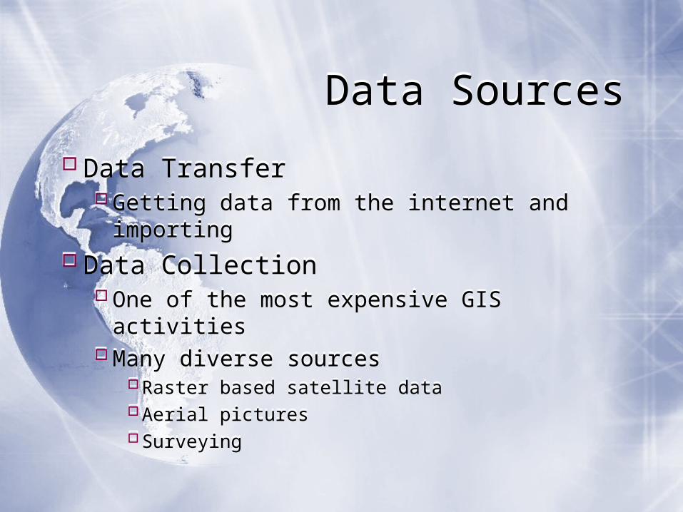
Data SourcesData Sources
Data TransferGetting data from the internet and importing
Data CollectionOne of the most expensive GIS activities
Many diverse sourcesRaster based satellite dataAerial picturesSurveying
Data TransferGetting data from the internet and importing
Data CollectionOne of the most expensive GIS activities
Many diverse sourcesRaster based satellite dataAerial picturesSurveying
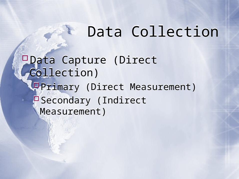
Data CollectionData Collection
Data Capture (Direct Collection)Primary (Direct Measurement)Secondary (Indirect Measurement)
Data Capture (Direct Collection)Primary (Direct Measurement)Secondary (Indirect Measurement)
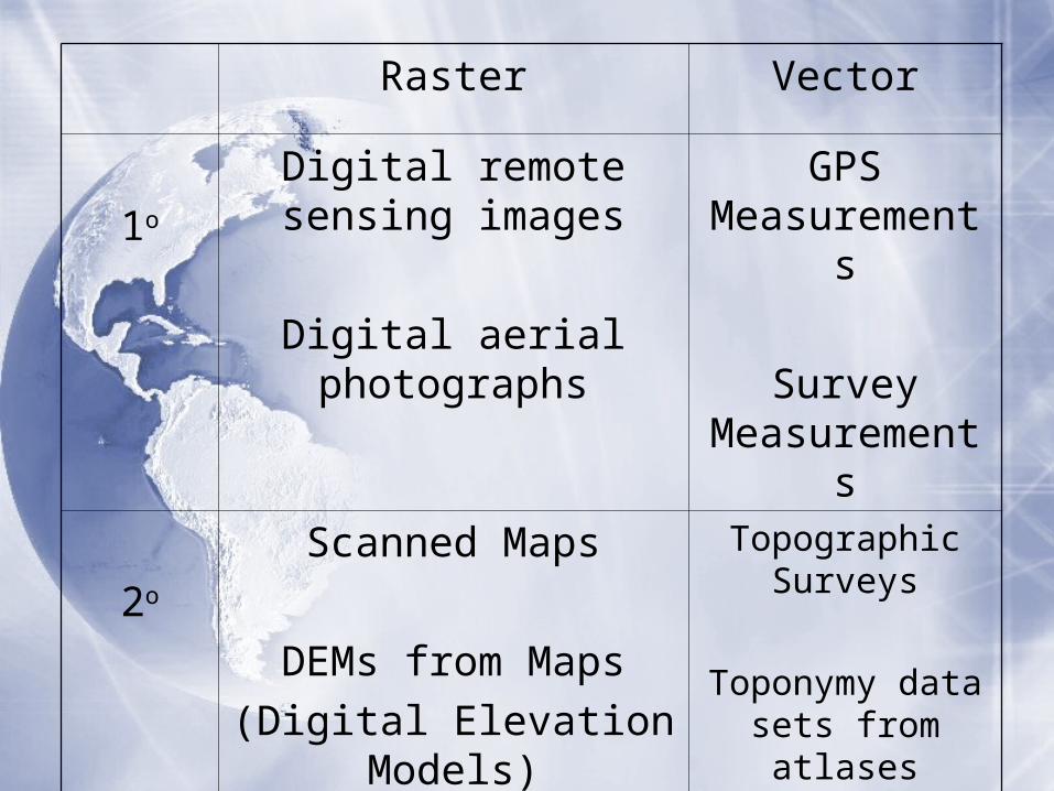
Raster Vector
1o
Digital remote sensing images
Digital aerial photographs
GPS Measurement
s
Survey Measurement
s
2o
Scanned Maps
DEMs from Maps(Digital Elevation
Models)
Topographic Surveys
Toponymy data sets from atlases
Table Digitizing
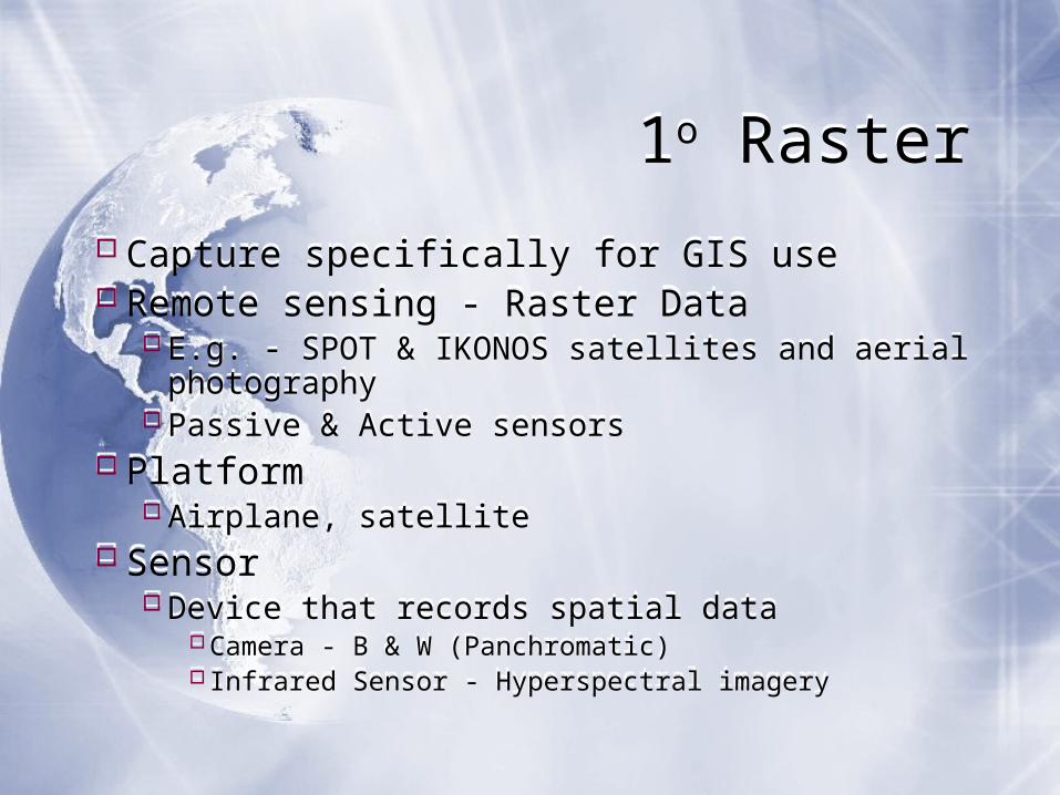
1o Raster1o Raster
Capture specifically for GIS useRemote sensing - Raster Data
E.g. - SPOT & IKONOS satellites and aerial photography
Passive & Active sensorsPlatform
Airplane, satelliteSensor
Device that records spatial dataCamera - B & W (Panchromatic)Infrared Sensor - Hyperspectral imagery
Capture specifically for GIS useRemote sensing - Raster Data
E.g. - SPOT & IKONOS satellites and aerial photography
Passive & Active sensorsPlatform
Airplane, satelliteSensor
Device that records spatial dataCamera - B & W (Panchromatic)Infrared Sensor - Hyperspectral imagery
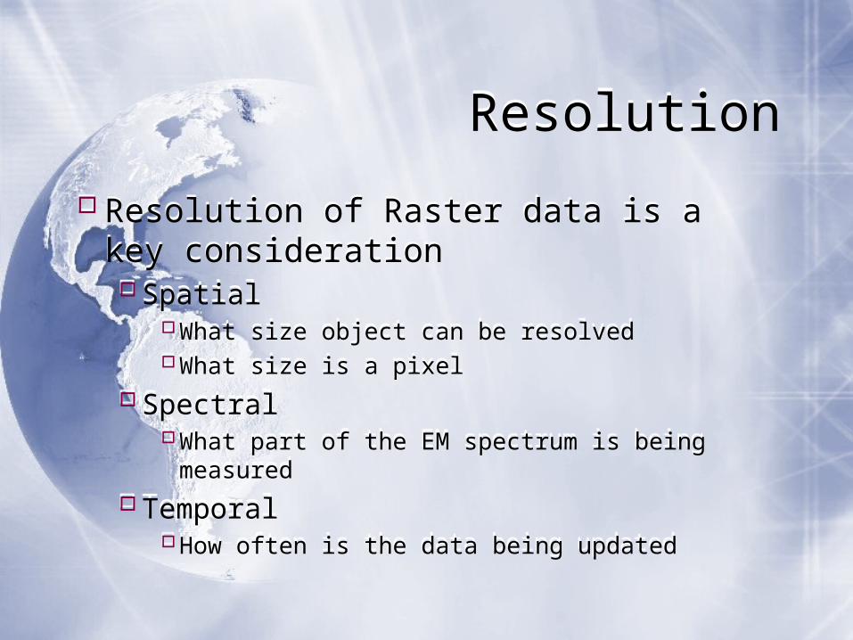
ResolutionResolution
Resolution of Raster data is a key considerationSpatial
What size object can be resolvedWhat size is a pixel
SpectralWhat part of the EM spectrum is being measured
TemporalHow often is the data being updated
Resolution of Raster data is a key considerationSpatial
What size object can be resolvedWhat size is a pixel
SpectralWhat part of the EM spectrum is being measured
TemporalHow often is the data being updated
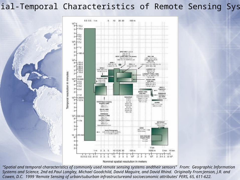
Spatial-Temporal Characteristics of Remote Sensing Systems
"Spatial and temporal characteristics of commonly used remote sensing systems andtheir sensors" From: Geographic Information Systems and Science, 2nd ed.Paul Longley, Michael Goodchild, David Maguire, and David Rhind. Originally From:Jenson, J.R. and Cowen, D.C. 1999 'Remote Sensing of urban/suburban infrastructureand socioeconomic attributes' PERS, 65, 611-622.

1o Vector1o Vector
Surveying Location of objects determined by angle and distance measurements from known locations
Uses expensive field equipment and crewsMost accurate method for large scale, small areas
GPSCollection of satellites used to fix locations on earth’s surface
Increased accessibility
Surveying Location of objects determined by angle and distance measurements from known locations
Uses expensive field equipment and crewsMost accurate method for large scale, small areas
GPSCollection of satellites used to fix locations on earth’s surface
Increased accessibility
2o Geographic Data Capture
2o Geographic Data Capture
Data collected for other purposes can be converted for use in GIS
Raster conversionsScanning of maps, aerial photographs, documents, etc
Important scanning parameters are spatial and spectral resolution
Digitizing, Batch VectorizationCommon human errors in digitizing
Overshoot, undershoot, dangling segment, sliver polygon
Automated remedies to digitizing errors are not perfect
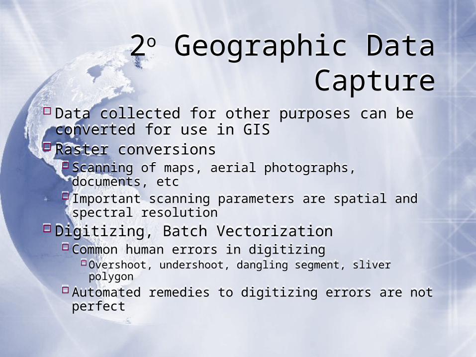

Quality StandardsQuality StandardsMetadata
Information about the dataWho Collected the dataHow was it collectedWhat datum was usedWhat projection was usedWhat is the precision of the dataWhat type of data is itWhen was the data last updated
There are standards established for different types of data and the metadata.
Metadata should be available for the data to be reliable.
Metadata should be available either for each data file, or a general metadata file will be available for a group of files.
MetadataInformation about the data
Who Collected the dataHow was it collectedWhat datum was usedWhat projection was usedWhat is the precision of the dataWhat type of data is itWhen was the data last updated
There are standards established for different types of data and the metadata.
Metadata should be available for the data to be reliable.
Metadata should be available either for each data file, or a general metadata file will be available for a group of files.
AccuracyAccuracyThe degree to which information on a map or a digital database matches true or accepted values.
Accuracy is an issue pertaining to the quality of data and the number of errors contained in a dataset or map.
The level of accuracy required for particular applications varies greatly.
Highly accurate data can be very difficult and costly to produce and compile.
The degree to which information on a map or a digital database matches true or accepted values.
Accuracy is an issue pertaining to the quality of data and the number of errors contained in a dataset or map.
The level of accuracy required for particular applications varies greatly.
Highly accurate data can be very difficult and costly to produce and compile.
http://www.colorado.edu/geography/gcraft/notes/error/error_f.html
PrecisionPrecision
The level of measurement and exactness of description in a GIS database.
Precise locational data may measure position to a fraction of a unit.It is important to realize that precise data - no matter how carefully measured - may be inaccurate.
Surveyors may make mistakes or data may be entered into the database incorrectly.

The level of precision required for particular applications varies greatly.Engineering projects such as road and utility construction require very precise information measured to the millimeter.
Demographic analyses of marketing or electoral trends can often make due with less, say to the closest zip code or precinct boundary.
Highly precise data can be very difficult and costly to collect.
http://www.colorado.edu/geography/gcraft/notes/error/error_f.html

Error in dataError in data
Positional Accuracy and PrecisionHorizontal and VerticalScale
Attribute Accuracy and PrecisionNon-spatial information linked to a locationE.g. Age, gender, income of a person at a particular address
Positional Accuracy and PrecisionHorizontal and VerticalScale
Attribute Accuracy and PrecisionNon-spatial information linked to a locationE.g. Age, gender, income of a person at a particular address
Conceptual Accuracy and PrecisionAbstraction and classification of real-world phenomena.
The user determines what amount of information is used and how it is classified into appropriate categories.Rivers, streams, tributariesElectrical utilities infrastructure
Voltage, line size, line type
Logical Accuracy and PrecisionInformation in a database can be employed illogically.
Information in a GIS database must be used and compared carefully if it is to yield useful results.
http://www.colorado.edu/geography/gcraft/notes/error/error_f.html
Canned Data vs External Data
Canned Data vs External Data
Canned Datadata that has been pre-screened and tested to work in a particular application.For example: the data sets in Mapping Our World and Getting to Know ArcGIS.
External DataData in the form that is made available by the supplier.For example: the data sets from SANDAG or SanGIS.
The data may not be in the same datum, projection etc.
The data may need to be manipulated before it can be projected correctly.
Downloading from Web Sources
Downloading from Web Sources
Use reliable sitesGovernment or Education Sites
Reliability of dataCheck the metadata for:
Source of the dataAccuracy and Precision of the dataDate of data collection and revision
Format of the dataCheck the metadata for:
DatumProjection
Use reliable sitesGovernment or Education Sites
Reliability of dataCheck the metadata for:
Source of the dataAccuracy and Precision of the dataDate of data collection and revision
Format of the dataCheck the metadata for:
DatumProjection