


![Ocean & Coastal Management · 2017-05-01 · effective coastal management [4–6]. Specific, well identified results have been obtained from a number of research studies related](https://static.fdocument.pub/doc/165x107/5f535aba8fc1d822427a21a7/ocean-coastal-management-2017-05-01-effective-coastal-management-4a6.jpg)
Languages
Pages
Legal

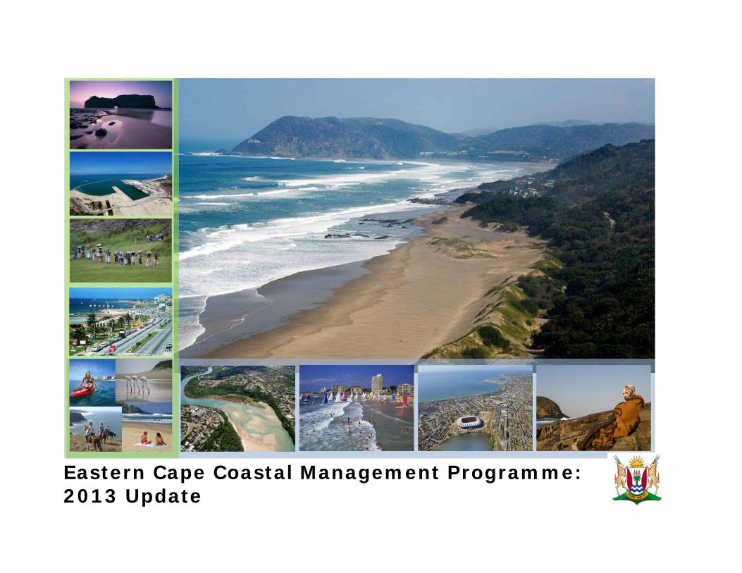
Eastern Cape Coastal Management Programme: 2013 Update
i
© Department of Economic Development, Environmental Affairs and Tourism
Suggested citation: Breetzke, T., Moore, L., and Meyer, C. 2013. Eastern Cape Coastal Management Programme: 2013 Update. Royal HaskoningDHV on behalf of tDepartment of Economic Development, Environmental Affairs and Tourism. 50pp.
Department of Economic Development, Environmental Affairs and Tourism Private bag X0054 BHISHO 5606
Royal HaskoningDHV PO Box 55, Pinetown 3600 SSI House, 6 Payne Street, 3610 Pinetown, South Africa Tel: +27 31 7195500, Fax: +27 31 7195505 Website: http://www.rhdhv.com
Authors: Tandi Breetkze, Luke Moore and Catherine Mayer

ii
TABLE OF CONTENTS1 INTRODUCTION ................................................................................................ 1
1.1 Background .........................................................................................................1 1.2 The importance of Coastal Management Programmes .........................................1 1.3 The aim and purpose of this Coastal Management Programme ............................2 1.4 Outcomes of the Coastal Management Programme ..............................................2
2 A VISION FOR THE EASTERN CAPE COAST ................................................ 3
3 GUIDING PRINCIPLES FOR THE EASTERN CAPE COAST ......................... 3
4 INVENTORY ANALYSIS: THE EASTERN CAPE COAST .............................. 5
4.1 Biophysical Characteristics ..................................................................................5 4.2 Socio-Economic Characteristics ..........................................................................8
5 PRIORITIES AND STRATEGIES .................................................................... 10
5.1 Incorporation and Alignment ............................................................................. 11 5.2 Key Themes for Action ..................................................................................... 11 5.3 Indicators for Monitoring Progress .................................................................... 11 5.4 The Five Year Plan: Priority Areas and Implementation .................................... 11
5.4.1 Priority area 1: Cooperative Governance ....................................... 12 5.4.2 Priority area 2: Coastal Planning and Development ...................... 16 5.4.3 Priority area 3: Climate change and dynamic coastal processes .... 20 5.4.4 Priority area 4: Land and marine-based sources of pollution ......... 22 5.4.5 Priority area 5: Estuaries ................................................................ 24 5.4.6 Priority area 6: The facilitation of coastal access ........................... 28 5.4.7 Priority area 7: Awareness, education, training, capacity building and information .............................................................................................. 31 5.4.8 Priority area 8: Compliance, monitoring and enforcement ............. 34 5.4.9 Priority area 9: Natural Resource Management ............................. 36
6 NORMS AND STANDARDS FOR THE EASTERN CAPE COASTAL ZONE 39
6.1 General Environmental Management Guidelines for the Eastern Cape Coast .... 39 6.2 Wild Coast Management Guidelines .................................................................. 41 6.3 Specific Standards ............................................................................................. 44
6.3.1 Coastal Set-back line Demarcation and Establishment ................... 44
7 REVIEW AND AMENDMENT .........................................................................
8 CONCLUSIONS ................................................................................................
9 BIBLIOGRAPHY ..............................................................................................
10 APPENDICES ................................................................................................
LIST OF FIGURES Figure 1: The coastal management programme development process (Oceans and CoastBranch of the Department of Enviornmental Affairs, 2012) .............................................Figure 2: The Eastern Cape coast: a diverse provincial asset ..........................................Figure 3: Guiding principles for the Eastern Cape Coast ................................................Figure 4: The Eastern Cape coastline by habitat type .....................................................Figure 5: Landcover, marine bioregions, main rivers and estuaries of the Eastern Cape Figure 6: Protected areas, marine protected areas and critical biodiversity areas in theEastern Cape ...................................................................................................................Figure 7: Administrative boundaries of the Eastern Cape ................................................Figure 8: Settlement patterns in the Eastern Cape ...........................................................Figure 9: Gross value added per region for the Eastern Cape in 2009 ............................
LIST OF TABLES Figure 1: The coastal management programme development process (Oceans and CoastBranch of the Department of Enviornmental Affairs, 2012) .............................................Figure 2: The Eastern Cape coast: a diverse provincial asset ..........................................Figure 3: Guiding principles for the Eastern Cape Coast ................................................Figure 4: The Eastern Cape coastline by habitat type .....................................................Figure 5: Landcover, marine bioregions, main rivers and estuaries of the Eastern Cape Figure 6: Protected areas, marine protected areas and critical biodiversity areas in theEastern Cape ...................................................................................................................Figure 7: Administrative boundaries of the Eastern Cape ................................................Figure 8: Settlement patterns in the Eastern Cape ...........................................................Figure 9: Gross value added per region for the Eastern Cape in 2009 ............................

1
1 INTRODUCTION
1.1 BACKGROUND
Following the publication and adoption of the inaugural Coastal Management Programme (CMP) for the Eastern Cape in 2004, the Eastern Cape Department of Economic Development, Environmental Affairs and Tourism (DEDEAT) appointed Royal HaskoningDHV in August 2012 to update this policy. This review process is in line with the requirements of the National Environmental Management: Integrated Coastal Management Act (Act No. 24 of 2008, hereafter the ICM Act), as well as the underlying principles of integrated coastal management (ICM) and the White Paper for Sustainable Coastal Development in South Africa, deemed as South Africa’s national CMP at the time of reporting.
The updated CMP builds upon the existing strengths and successes of the management tools and legislation represented by the inaugural 2004 CMP (Coastal and Environmental Services, EnviroFish Africa, MBB Consulting Engineers Inc, 2004), and structures these within the framework of the requirements of the updated documentation identified by the gap analysis as well as the principles of integrated coastal management. This link is important as the 2004 CMP represents the starting point for the cycle of integrated coastal management (ICM) in the Eastern Cape. The CMP process is represented schematically by Figure 1, where the ICM cycle in the Eastern Cape has attained a first level of maturity by reaching the assessment and review phase of the cycle. The CMP update process therefore commences in step 10 in Figure 1, following which points 2 through 6 have been undertaken.
1.2 THE IMPORTANCE OF COASTAL MANAGEMENT PROGRAMMES
To understand the importance of CMPs, the concept of integrated coasmanagement (ICM), the underlying management system that informs coasmanagement in South Africa, must be briefly examined.
Integrated Coastal Management (ICM) is a process for the management ocoastal area using an integrated and inclusive approach, taking cognisance of aspects of the coastal zone, including geographical and political boundaries, in
Figure 1: The coastal management programme development process (Oceans and Coasts Branof the Department of Enviornmental Affairs, 2012)
2
Easte
rn C
ape C
oasta
l Managem
ent P
rogra
mm
e
attempt to achieve sustainable coastal development (IUCN, 2006, cited in Celliers et al., 2010). The original concept of sustainable development was coined in the late 1960s, early 1970s, (see UNEP, 1972, cited in Celliers et al., 2010) and explicitly suggested that economic growth and environmental integrity were not mutually exclusive. The goal of ICM, according to the Joint Group of Experts on the Scientific Aspects of Marine Environmental Protection (GESAMP, 1996, cited in Celliers et al., 2010) is to improve the quality of life of human communities who depend on coastal resources while maintaining the biological diversity and productivity of coastal ecosystems. This can be expanded to read (Olsen, 2003, cited in Celliers et al., 2010):
Specific improvement of the bio‐physical condition of the coastal area; and
Specific improvement in the quality of life of human populations in the coastal area.
Thus, the ICM process must integrate government with the community, science with management, and sectoral with public interests in preparing and implementing actions that combine investment in development with the conservation of environmental qualities and functions.
Best practice principles for successful ICM are summarised as follows:
Roles and responsibilities must be clearly defined to encourage buy‐in and ownership of ICM goals;
Sectoral involvement and empowerment must be cross‐cutting;
Best available data and information must be utilised at all times;
Continuity and credibility of data collection are essential to long‐term progress monitoring and the development of affective indicators;
Well‐defined and diverse indicators must be used to evaluate progress and initiate change where necessary;
ICM must bring key issues to the fore and promote their inclusion in other sector plans and policies; and
Conflict resolution and consensus based decision‐making are key to the ICM process.
One of the ways in which ICM is put into practice in South Africa is through the development of coastal management programmes (CMPs).
1.3 THE AIM AND PURPOSE OF THIS COASTAL MANAGEMENT
PROGRAMME
Broadly, the aim of a provincial CMP is to achieve the integrated coastal management objectives in the coastal area under provincial jurisdiction, part of which means ensuring consistency with national objectives. In line with the aim and purpose of the inaugural CMP, this programme takes the unique and diverse qualities of the Eastern Cape coast into account through an inventory analysis (Section 4) and identifies areas of concern that require emphasis (Section 5 and 6). The CMP thereafter uses this information to present a strategy for both the public and private sectors to create opportunities to enhance the livelihoods of coastal communities. A further aim of this updated CMP is to aid decision‐making and improve coastal governance, as well as raise awareness of the value of the coastal area.
1.4 OUTCOMES OF THE COASTAL MANAGEMENT PROGRAMME
The CMP is intended to build on and update existing provincial coastal policies, and provide an updated, coherent, integrated and co‐coordinated framework and directive for coastal management and decision‐making, as per the ICM Act legislative requirements. It establishes mechanisms for the comprehensive participation of representatives from all sectors of coastal communities, as well as providing management tools to empower decision‐makers to manage and utilise the coast. In addition, the CMP provides an input into local planning initiatives, such as Integrated Development Plans and Spatial Development Frameworks of coastal municipalities.

3
The CMP cannot provide detailed, specific information regarding spatial coastal planning. It also cannot provide a solution to all of the problems experienced along the Eastern Cape coast.
2 A VISION FOR THE EASTERN CAPE COAST The 2004 vision for the Eastern Cape coast is adopted without amendment.
Figure 2: The Eastern Cape coast: a diverse provincial asset
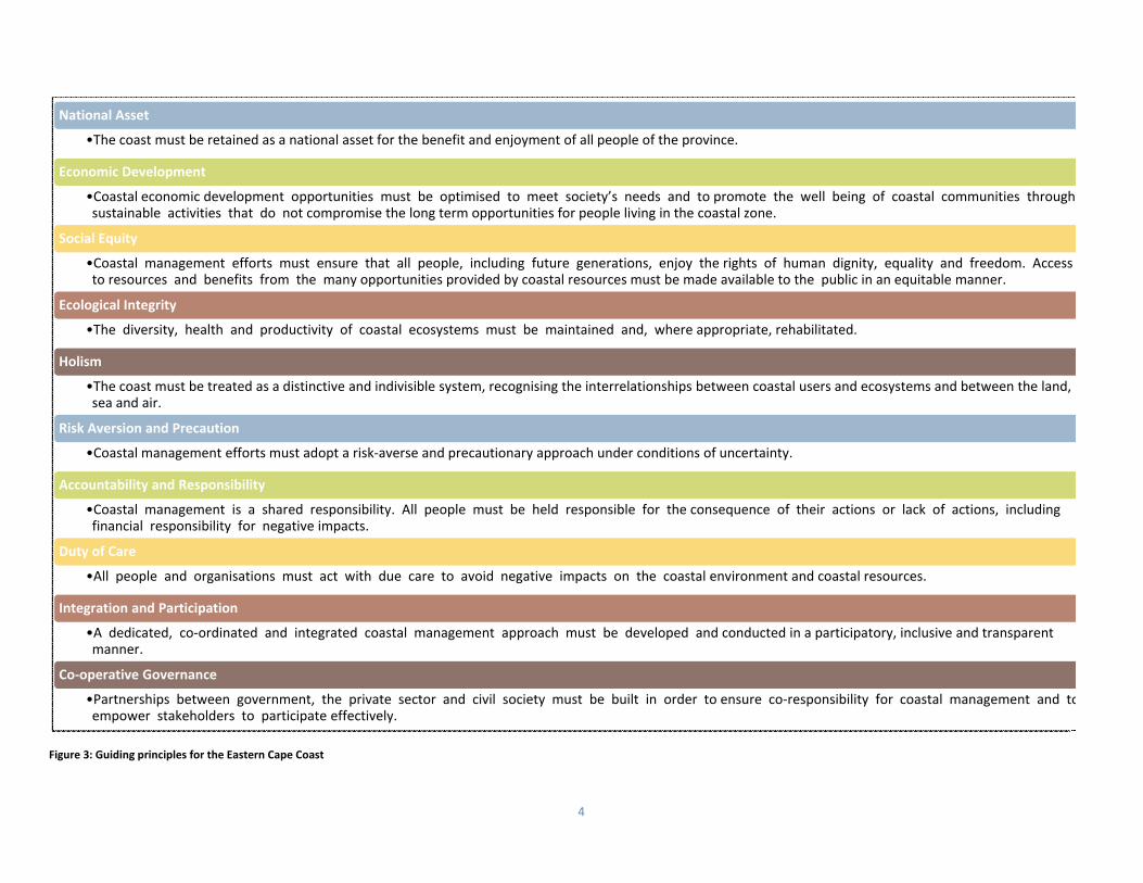
3 GUIDING PRINCIPLES FOR THE EASTERN CAPE COAST The 2004 guiding principles for the Eastern Cape coast as detailed in the 20CMP are adopted without amendment and are detailed in Figure 3.
We, the people of the Eastern Cape, recognise the intrinsic value, and appreciate the scenic beauty, diversity and richness of our unique coastline.
We aim to take ownership of the coast and foster a spirit of custodianship and shared responsibility as our coast is a unique shared asset, which has social, cultural, ecological and economic value.
We aspire to manage the coast in an integrated manner that takes both the spiritual and biological value into account.
We strive to utilise the natural resources of our diverse coastline in a sustainable and equitable manner, which maximises the benefits for all people of the province and ensures the long term maintenance of biodiversity and ecological integrity of coastal habitats.
We strive to promote sustainable development and alleviate poverty in an equitable and participatory manner that considers the requirements of all stakeholders, and takes cognisance of the conservation and biological importance of our coastline as well as national and provincial interests.
We seek to guide the management of the Eastern Cape coast in a way that eliminates the threats of unsustainable utilisation of the coastal resources while optimising the opportunities that can be derived from the coastal zone.
4
Figure 3: Guiding principles for the Eastern Cape Coast
National Asset
•The coast must be retained as a national asset for the benefit and enjoyment of all people of the province.
Economic Development
•Coastal economic development opportunities must be optimised to meet society’s needs and to promote the well being of coastal communities through sustainable activities that do not compromise the long term opportunities for people living in the coastal zone.
Social Equity
•Coastal management efforts must ensure that all people, including future generations, enjoy the rights of human dignity, equality and freedom. Access to resources and benefits from the many opportunities provided by coastal resources must be made available to the public in an equitable manner.
Ecological Integrity
•The diversity, health and productivity of coastal ecosystems must be maintained and, where appropriate, rehabilitated.
Holism
•The coast must be treated as a distinctive and indivisible system, recognising the interrelationships between coastal users and ecosystems and between the land, sea and air.
Risk Aversion and Precaution
•Coastal management efforts must adopt a risk‐averse and precautionary approach under conditions of uncertainty.
Accountability and Responsibility
•Coastal management is a shared responsibility. All people must be held responsible for the consequence of their actions or lack of actions, including financial responsibility for negative impacts.
Duty of Care
•All people and organisations must act with due care to avoid negative impacts on the coastal environment and coastal resources.
Integration and Participation
•A dedicated, co‐ordinated and integrated coastal management approach must be developed and conducted in a participatory, inclusive and transparent manner.
Co‐operative Governance
•Partnerships between government, the private sector and civil society must be built in order to ensure co‐responsibility for coastal management and toempower stakeholders to participate effectively.

5
4 INVENTORY ANALYSIS: THE EASTERN CAPE COAST South Africa’s coastline is extremely diverse, and as such, its defining characteristics need to be described at a provincial level. The combination of biophysicsocioeconomic, developmental and demographic characteristics, which make the Eastern Cape coast so unique, are described in this section. This analysis draws from masources, including data and information that has become available post 2004, without discarding existing information and components of the 2004 CMP that remrelevant to the updated CMP and ICM process.
4.1 BIOPHYSICAL CHARACTERISTICS
The Eastern Cape coastline extends for approximately 875 km along the east coast of South Africa, representing roughly a quarter of South Africa’s total shoreline. The coast comprises nearly one third of the province’s total jurisdictional boundary and consists of sandy beaches, rocky headlands, wave‐cut platforms, bays and steep cliffs, which provide a wide variety of habitats for inshore marine organisms (DEAT, 1998; Coastal and Environmental Services, 2004; Figure 4). The coastline of the former Transkei, to the north, is typically undulatory and sometimes extremely rugged, resulting in the retention of one of the most unspoilt and scenic stretches of the South African coastline due to limited accessibility (Arcus Gibb Engineering and Science, 2010). As one travels further south, the coastal topography becomes less undulatory and, in places, an extensive flat coastal plain exists (e.g. Nelson Mandela Metropolitan and Kouga Municipalities) while the coastline in the far south becomes undulatory again with steep‐sided cliffs falling away to the sea (Arcus Gibb Engineering and Science, 2010; Figure 4).
The Eastern Cape has the most estuaries of all the provinces, with 159 systems stretching from the Bloukrans Estuary in the west to the Umtentwana Estuary in the east (Van Niekerk & Turpie, 2012). Together they represent approximately 50% of South Africa‘s estuaries. The major systems include the Great Fish,
Figure 4: The Eastern Cape coastline by habitat type
Source: Environmental Potential Atlas for South Africa (DEAT, 2001)

6
Nahoon, Kei, Mtata and Umzimvubu estuaries (DEAT, 1998). The majority of the Eastern Cape estuaries are in good (28%) to excellent (50%) ecological condition, with for no modifications, respectively. Three systems, namely the Baakens, Papenkuils, and Coega (Ngcura) estuaries, have been irreversibly modified and are consequensignificantly degraded without any likelihood of natural estuarine function being restored. Thirteen of the province’s estuaries are considered critically endangered aendangered. These are predominantly Permanently Open estuaries. The remainder are deemed least threatened. The major threats to estuaries in the Eastern Cainclude: urban development within the coastal zone; modification of freshwater runoff; overfishing and poaching; climate change; and alien invasive species.
In terms of national estuarine conservation targets, 57 of the 120 core estuaries required meet the national biodiversity targets are located in the Eastern Cape, 30 of which require full conservation protection and 27 requiring partial protection (Van Niekerk & Turpie, 2012). Thus far, various forms of environmental management programmes (e.g. mangroves, natural resources) and/or active forums exist for five estuarine systems (DEDEA, 2010). A further six have formal estuary management plans in various stages of completion, while the development process was recently initiated for the Nahoon Estuary (A. Matoti pers comm., 2011; Van Niekerk & Turpie, 2012).
In terms of landcover, much of the province’s cultivation, settlement, and plantations are located in close proximity to the coast, effectively illustrating the desirability of the coastal area for settlement, resource use and human activity (Figure 5). These areas are interspersed with natural habitat, although they have become increasingly fragmented along the coast of the Eastern Cape. Four marine bioregions are found off the coast of the Eastern Cape, and include the Agulhas and Natal bioregions, as well as the Indo‐Pacific and South‐west Indian Ocean offshore bioregions (Sink, et al., 2012).
The most prominent oceanographic feature of the Eastern Cape coast is the Agulhas Current that carries warm tropical water southwestwards past the south coast of South Africa with an average temperature of 22 °C in August and 27 °C in March (Arcus Gibb Engineering and Science, 2010). Tinshore, northeastward trending littoral drift counter‐current carries sand along the coastline, eroding it at some places and depositing sand at others to form new beach(Arcus Gibb Engineering and Science, 2010). The entire Eastern Cape coastline experiences strong wave action because of its exposure to the southern swell, with sw
Figure 5: Landcover, marine bioregions, main rivers and estuaries of the Eastern Cape
Data source: South African National Biodiversity Institute 2009

7
heights in excess of five meters frequently recorded (Arcus Gibb Engineering and Science, 2010). The Wild Coast, stretching from the Great Kei River to the UmtamvuRiver, is widely regarded as a coastal region of exceptional scenic beauty with a very high diversity of indigenous plants and animals. The Pondoland Coast is internationally recognized centre of endemism, meaning that a high proportion of indigenous plant species only occur here and nowhere else in the world (Eastern CaDepartment of Economic Development, Environmental Affairs and Tourism, 2012).
The Eastern Cape has a diverse and economically important inshore fishery, which is targeted by subsistence, recreational and commercial fishers (Arcus Gibb Engineerand Science, 2010). The use of coastal resources by subsistence fishers, focussed along the former Transkei coast, is important in sustaining the rural livelihoods in what alargely impoverished communities, while both the recreational and commercial line‐fisheries play an important role in the local and regional economy (Arcus GEngineering and Science, 2010). The inshore fishery in the Eastern Cape is under threat from over‐exploitation, with resources continuing to decrease with the collapsemost of the stocks of commercial linefish species (Arcus Gibb Engineering and Science, 2010).
In terms of terrestrial biodiversity, Berliner and Desmet (2007) made use of systematic conservation planning to map critical biodiversity areas required for biodiversity persistence, which informs protected area and rural land‐use planning in the Eastern Cape. Critical biodiversity areas (CBAs) are depicted spatially for the province in Figure 6, which shows the location of natural, near‐natural and functional landscapes respectively. Existing protected areas, as per the 2011 National Biodiversity Assessment, are overlaid to indicate levels of formal protection for the biodiversity assets of the Eastern Cape. CBAs are categorized as natural landscapes and are scattered throughout the Eastern Cape coastal belt, particularly in the Wild Coast area. These are interspersed with near natural landscape CBAs, which highlights the high biodiversity value of the coastal area. There are a number of protected areas along the coast of the Eastern Cape, including 12 marine protected areas (MPAs) and island reserves which have varying levels of permissible extraction and resource use. Much of the Wild Coast region’s CBAs remain unprotected (Figure 6). Figure 6: Protected areas, marine protected areas and critical biodiversity areas in the Eastern Cape
Data source: Berliner and Desmet 2007, South African National Biodiversity Institute

8
4.2 SOCIO‐ECONOMIC CHARACTERISTICS
Administratively, the Eastern Cape is divided into two metropolitan, six district, and 37 local municipalities (Figure 7). Of these local authorities, four district, 15 local and both metropolitan municipalities are coastal, having the Indian Ocean as their eastern boundary.
Approximately 6.1 million people were recorded as inhabiting the Eastern Cape in 2011, which accounted for 12.7% of South Africa‘s population, a marked decline since 1996 when the Eastern Cape population represented 15.1% of the national total (Statistics South Africa, 2012). All coastal district municipalities in the Eastern Cape showed an increase in population between 1996 and 2011, with the exception of the Amathole district, which showed a decrease of almost 10% (Table 1). This anomaly is attributable to the declaration of Buffalo City as a metropolitan municipality following the 2011 boundary realignment process, and the subsequent loss of this densely populated area from the district municipality’s area of jurisdiction. The highest growth occurred in the Nelson Mandela Bay Metropolitan and Cacadu District municipalities with approximately 16% and 18% respectively between 1996 and 2011.
Table 1 uses 2009 landcover data to depict the spatial pattern of settlement in the Eastern Cape.
While the O.R.Tambo district municipality had the highest population statistically between 1996 and 2011 (Table 1), Figure 8 shows that settlement was scattered throughout this district, and that coastal population density in ftends to be relatively low due to apartheid era spatial planning (Coastal and Environmental Services, 2004). Spatially, the Eastern Cape coast is most densely populatedthe two metropolitan municipalities, followed by the Amathole and Cacadu districts. Residential areas are concentrated in the two largest cities, Port Elizabeth and ELondon (Coastal and Environmental Services, 2004).
Figure 7: Administrative boundaries of the Eastern Cape
Data source: Municipal Demarcation Board

9
The Eastern Cape supports a variety of economic activities, including significant manufacturing and industry (predominantly in Port Elizabeth and East London); tourism ‐ because of resort development on many river mouths; sand mining; and forestry (DEAT, 1998). Primary development nodes in the Eastern Cape include the port cities of East London and Port Elizabeth; the former comprising the only river port in the country while the latter is emerging as a major economic and industrial hub through the location of the Coega Industrial Development Zone (IDZ) in close proximity to the city (Celliers, Breetzke, & Moore, 2010). Other significant development nodes include Port Alfred on the Sunshine Coast and Port St. Johns on the Wild Coast.
In terms of development potential, according to the Provincial Growth and Spatial Development Plan (Tshani Consulting cc, 2010), the Eastern Cape coast has high growth potential with growing coastal resort settlements, tourism attractions and relatively well resourced agricultural areas. These areas are situated between urban nodes as well as having access to national and international markets.
Table 1: Population change in Eastern Cape coastal district municipalities 1996‐2011
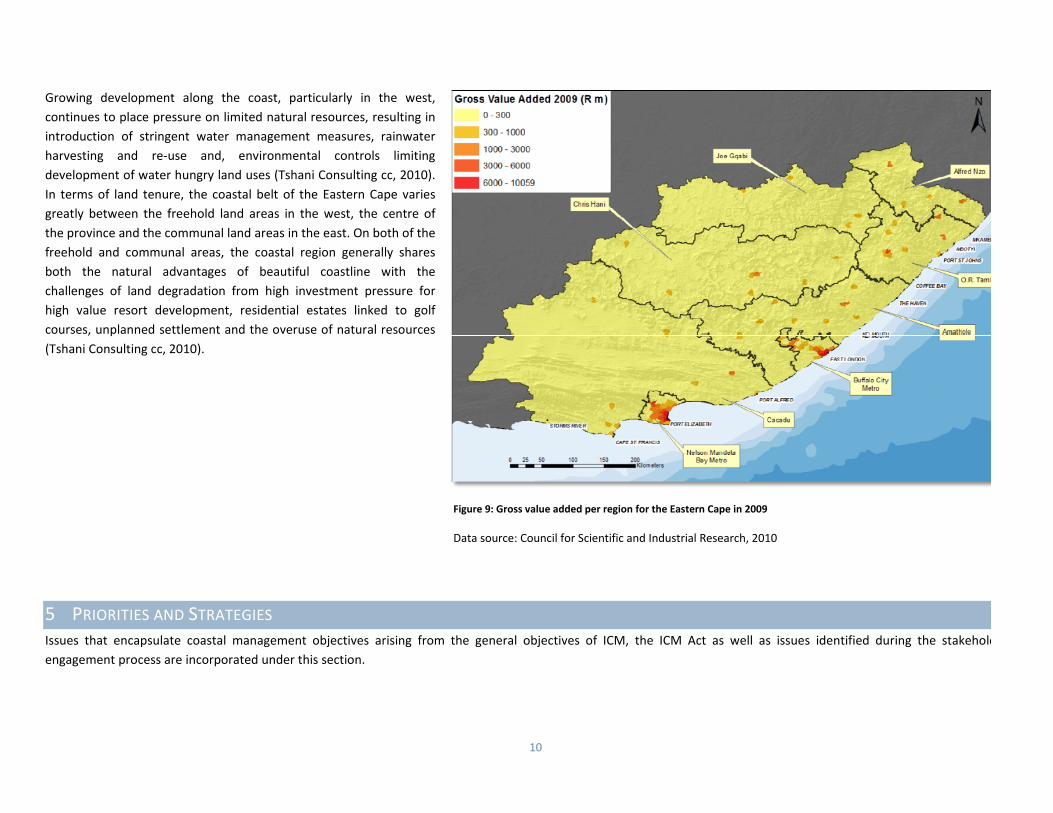
The concept of Gross Value Added (GVA) has been used as an indicator for making estimatesregional economic activity (Naudé, Badenhorst, Zietsman, Van Huyssteen, & Maritz, 2007) andbroadly similar to what is more generally known as Gross Geographic Product (GGP). Figureclearly shows that economic capacity is concentrated around the port cities of Port Elizabeth aEast London in the Nelson Mandela and Buffalo City metropolitans respectively. These regioform the economic backbone of the province in terms of GVA, with less significant contributionsthe Cacadu district at Port Alfred and St Francis Bay; and within O.R. Tambo at Port St. Johns.
District 1996 2011 % ChangeO.R.Tambo 1248950 1364940 8.5%
Nelson Mandela Bay 969518 1152120 15.8% Amathole 981161 892637 ‐9.9% Alfred Nzo 749585 801344 6.5Buffalo City 685727 755200 9.2% Cacadu 370159 450584 17.8%
Data source: Statistics South Africa 2012
Figure 8: Settlement patterns in the Eastern Cape
Data source: South African National Biodiversity Institute 2009
10
Growing development along the coast, particularly in the west, continues to place pressure on limited natural resources, resulting in introduction of stringent water management measures, rainwater harvesting and re‐use and, environmental controls limiting development of water hungry land uses (Tshani Consulting cc, 2010). In terms of land tenure, the coastal belt of the Eastern Cape varies greatly between the freehold land areas in the west, the centre of the province and the communal land areas in the east. On both of the freehold and communal areas, the coastal region generally shares both the natural advantages of beautiful coastline with the challenges of land degradation from high investment pressure for high value resort development, residential estates linked to golf courses, unplanned settlement and the overuse of natural resources (Tshani Consulting cc, 2010).
5 PRIORITIES AND STRATEGIES Issues that encapsulate coastal management objectives arising from the general objectives of ICM, the ICM Act as well as issues identified during the stakeholdengagement process are incorporated under this section.
Figure 9: Gross value added per region for the Eastern Cape in 2009
Data source: Council for Scientific and Industrial Research, 2010
11
Easte
rn C
ape C
oasta
l Managem
ent P
rogra
mm
e
The strategic value of the coastal zone is well understood in the role that it plays in aiding human development. Given its importance, demographic, socio‐economic and spatial development trends are among the key informants of coastal management priorities, strategies and objectives for the updated Eastern Cape CMP.
5.1 INCORPORATION AND ALIGNMENT
The update of a policy such as the CMP requires, among other things, the analysis of existing documentation to determine which components need to be incorporated into the updated document and which need to be updated or omitted. The stand‐alone alignment report component of the CMP update process focused on the synthesis and incorporation of key legislation, policy documents and sector plans which have been developed or updated since the last CMP was adopted in 2004. The outputs of this report have informed this document.
5.2 KEY THEMES FOR ACTION
The White Paper for Sustainable Coastal Development proposed key themes for action as the implementation framework for CMPs, and this approach was adopted for the inaugural version of the Eastern Cape CMP in 2004. In line with the structure of the draft Guide to the Development of CMPs in South Africa (Oceans and Coasts Branch of the Department of Enviornmental Affairs, 2012), the implementation framework has been amended to reflect priority areas for implementation for the current ICM cycle. This shift has been incorporated into this updated CMP.
5.3 INDICATORS FOR MONITORING PROGRESS
If undertaken correctly, indicators serve both as a corrective function during the project cycle ‐ enabling timely adjustments, and/or as a guide to structuring future projects more effectively (Oceans and Coasts Branch of the Department of Enviornmental Affairs, 2012). With this in mind, the priority areas for implementation (Section 5.4) also include indicators to allow for evaluation of progress. These fall under the umbrella categories of governance, ecological and socioeconomic indicators.
5.4 THE FIVE YEAR PLAN: PRIORITY AREAS AND IMPLEMENTATION
This section of the CMP provides detailed direction for achieving the coastal management vision (Section 2) during the current ICM cycle. The aim of these priority areas and implementation strategies is to address the key issues of concern, and build upon directives outlined during the Gap Analysis and Inventory Analysis components.
Prioritisation was classified as follows:
H Implementation actions requiring immediate attention and to be completed within 2 years
Less critical implementation actions to be completed before 3 years
Least critical implementation actions to be completed before end of the 5 year cycle
M
L

12
5.4.1 PRIORITY AREA 1: COOPERATIVE GOVERNANCE
FEATURES OF THIS PRIORITY AREA:
Participation of all stakeholders, coastal governance & co‐responsibility; Integrated, co‐ordinated decision making, planning and management; Continued learning and practical implementation of programmes and processes; and Compliance with International conventions, protocols and agreements.
KEY ISSUES / GOALS IN PRIORITY AREA 1
Goal 1A To ensure meaningful public participation, and to promote partnerships between all forms of government, the private sector and civil socie(NGOs, private sector & traditional leadership) in order to foster co‐responsibility in coastal management
Objectives
Public participation; Partnerships Co‐responsibility
Overview
There shall be meaningful public participation in all coastal planning and management efforts.

13
Easte
rn C
ape C
oasta
l Managem
ent P
rogra
mm
e
Organs of State shall proactively seek to develop partnerships with the private sector, civil society and the research community in coastal planning and management.
A caring and responsible attitude towards the coast shall be encouraged amongst all coastal‐resource users to foster co‐responsibility for its management.
Goal 1B To promote a dedicated, co‐operative, co‐ordinated and integrated coastal planning and management approach
Objectives
Interrelationships Dedicated effort Integration and co‐ordination Roles and responsibilities Consensus‐building
Overview
All planning and management efforts shall demonstrate that the inter‐relationships between coastal ecosystems and human users, have been taken into account.
Provision shall be made to ensure that there is adequate financial support (dedicated resource allocation for coastal plans and management), suitably trained and experienced personnel, appropriate technical equipment and capacity for coastal planning and management is sufficient for organs of state, including municipalities, to carry out their mandate effectively.
Institutional arrangements shall promote dialogue, co‐operation, co‐ordination and integration within and between government departments, the private sector and civil society.
The roles and responsibilities of government departments must be clarified and clearly understood at all levels of government (national, provincial and local).
Conflict shall be resolved wherever possible in a collaborative problem‐solving, consensus‐building manner.
Goal 1C To conduct coastal planning and management activities in a manner that promotes learning through continuous research, monitoring, review and adaptation
Objectives
Coastal management activities Practical implementation
Overview
The dedicated coastal management initiative developed must continue to be implemented and adapted through a process of continuous research,
14
Easte
rn C
ape C
oasta
l Managem
ent P
rogra
mm
e
monitoring, review and adaptation. Coastal planning and management activities shall be strategic, focused, practical and operational as well as SMART1
Goal 1D To fulfil international and trans‐boundary responsibilities, whilst retaining South Africa’s sovereignty
Objectives
International conventions, protocols and agreements Overview
Relevant international conventions, protocols and agreements shall be complied with as they relate to the Eastern Cape Province
PRIORITY AREA 1: COOPERATIVE GOVERNANCE
Implementation strategies
Indicators Priority
Work Plan Resource Plan
Time frame Lead agency Supporting agencies
Budget Potential funders
1
Develop a database of coastal stakeholders including researchers, managers and key contacts/ stakeholders
Developed database H ongoing DEDEAT Coastal stakeholders
Operational costs DEDEAT
2 Establishment of the provincial coastal committee
Terms of reference Minutes of meetings
H asap DEDEAT Coastal stakeholders
Operational costs DEDEAT
3
Develop mechanisms for co‐operative governance between organs of state and ensure co‐ordination
A record of diverse attendance at PCC meetings
H ongoing DEDEAT Other relevant state departments
Operational budget
DEDEAT
4 Assessment of spatial distribution of ICM personnel and increase their capacity
Completed spatial capacity assessment
Participation in capacity building programmes
Increased capacity
H
Within 6 months then ongoing
DEDEAT DEA Initial R250 000 then R100000 per annum
DEDEAT, DEA
1 Specific, measurable, attainable, realistic and time bound

15
Easte
rn C
ape C
oasta
l Managem
ent P
rogra
mm
e
Implementation strategies
Indicators Priority
Work Plan Resource Plan
Time frame Lead agency Supporting agencies
Budget Potential funders
5 Alignment of EC CMP with existing and future IDPs, SDFs and other spatial planning tools
Assessment of all coastal IDPs, SDFs
Coastal components incorporated in IDPs
H
Assessment by end 2013 Inclusion by next IDP review
DEDEAT Municipalities Initial R150 000 then operational costs
DEDEAT
6 Establishment of municipal coastal committees
Terms of reference Minutes of meetings
M Within 1 year
District & metro
DEDEAT, coastal stakeholders
Operational costs District & Metro’s
7 Establishment of co‐management systems
Systems established Memorandum of
Agreements M ongoing
DEDEAT / COGTA
communities R100 000 / annum
DEDEAT / COGTA
8 Incorporation of coastal management strategies into other forums
Cross pollination of agenda items on other forums
M ongoing DEDEAT Other relevant state departments
Operational budget
DEDEAT
9
Identification of international obligations and best practice and incorporation into relevant frameworks
Assessment of relevant aspects of international obligations and incorporation of relevant aspects into future CMP updates
L End 2015 DEA
DEDEAT, municipalities
Operational costs (part of National CMP)
DEA

16
5.4.2 PRIORITY AREA 2: COASTAL PLANNING AND DEVELOPMENT
FEATURES OF THIS PRIORITY AREA:
Emphasis on local economic development opportunities and approval procedures; Identification and exploitation of sustainable livelihood opportunities; and Holistic planning and development processes with emphasis on sustainable and equitable spatial development trends in the coastal zo
KEY ISSUES / GOALS IN PRIORITY AREA 2
Goal 2A To promote the diversity, vitality and long‐term viability of coastal economies and activities, giving preference to those that are distinctcoastal or dependent on a coastal location taking the upliftment of coastal communities into account
Objectives
Economic development potential Approval procedures Coast‐dependant activities Ports and related facilities Public facilities

17
Easte
rn C
ape C
oasta
l Managem
ent P
rogra
mm
e
Mariculture and aquaculture Tourism, leisure and recreation Mining
Overview
The long term economic development potential of coastal localities and regions shall be promoted. Coastal planning, administrative and management decision‐making approval procedures shall be clarified and streamlined and duplication avoided. Preference shall be given to distinctly coastal economic development opportunities and to activities that are dependent on a coastal location, rather than
to those activities that could be located inland. Cognisance needs to be taken of Ports, small‐craft harbours and related facilities and ski‐boat launch sites should be effectively managed Adequate and accessible public facilities shall be provided at appropriate coastal locations by both conservation authorities and coastal municipalities. Mariculture and aquaculture opportunities and initiatives shall be supported where such activities would have beneficial impacts for local communities Coastal tourism, leisure and recreational development opportunities’/initiatives shall be identified and promoted at appropriate coastal locations. All activities relating to coastal prospecting and mining rights shall be conducted in an environmentally responsible manner.
Goal 2B To alleviate coastal poverty through proactive coastal development initiatives that generate sustainable livelihood options
Objectives
Coastal development and sustainable livelihood opportunities Opportunities in conservation areas
Overview
Development opportunities that seek to eliminate coastal poverty shall be proactively identified through local economic development initiatives and should promote sustainable livelihood options.
Manage conservation areas in a manner that increases the value of the coastal zone.
Goal 2C To maintain an appropriate balance between built, rural and wilderness coastal areas
Objective
Coastal development
Overview
Coastal planning efforts shall proactively identify and promote new, sustainable, distinctively coastal development opportunities that retain the scenic beauty of coastal areas, while promoting the densification existing coastal corridors and nodes, and limiting ribbon development.

18
Easte
rn C
ape C
oasta
l Managem
ent P
rogra
mm
e
Goal 2D To design and manage coastal settlements to be in harmony with local and regional aesthetic, amenity, biophysical and cultural opportunities and constraints
Objectives
Design Management
Overview
Manage the design and built form of coastal settlements in harmony with the aesthetic, amenity, biophysical, economic, social and cultural opportunities and constraints of the coastal zone.
Coastal settlements and associated activities shall be managed to promote and enhance the socio‐economic benefits, diversity, health and productivity of coastal ecosystems.
PRIORITY AREA 2: COASTAL PLANNING AND DEVELOPMENT
Implementation strategies
Indicators
Priority Work Plan Resource Plan
Timeframe Lead agency Supporting agencies
Budget Potential funders
1
Compile an inventory and feasibility assessment of coastal resources that can be utilised as drivers of Local Economic Development, and provide limits to the level of utilisation of these resources
Inaugural coastal resources inventory
Incorporation of inventory into decision‐making frameworks
H End 2013 DEDEAT SANBI, Eastern Cape Parks, DEA
R500 000 SANBI, DEA, DEDEAT
2 Implement provincial coastal livelihoods strategy
Approved coastal livelihoods strategy
Coastal livelihoods assessments
H End 2013 DEDEAT Eastern Cape Parks, COGTA
R500 000 Eastern Cape Parks, DEDEAT
3
Compile up to date maps of the high water mark as per national standards, delineate coastal set‐back lines and the coastal zone as per the ICM Act
Delineated and adopted coastal zone
H End 2013 DEDEAT DEA, Surveyor General
R2.5m DEA, SG

19
Easte
rn C
ape C
oasta
l Managem
ent P
rogra
mm
e
Implementation strategies
Indicators Priority
Work Plan Resource Plan
Timeframe Lead agency Supporting agencies
Budget Potential funders
4
Establish buffer zones around conservation areas, with different levels of sustainable natural resource use
Buffer zone needs analysis undertaken
Coastal‐specific buffer zones established
Incorporation into bioregional planning
M End 2014 Eastern Cape Parks
DEDEAT, SANBI, DEA, SANParks
R200 000 initially, R500 000 for buffer zones and incorporation
Eastern Cape Parks, SANBI, SANParks
5 Streamline administrative procedures and databases for authorising coastal activities
Establishment of combined planning databases (GIS) and protocols for all departments
M End 2014 DEDEAT DWA Operational cost DEDEAT
6
Provide or improve public facilities at key nodes in order to meet recreational, health and safety needs
Key nodes/needs assessment for the province
Implementation of findings M
Initially end 2014 and then ongoing
DEDEAT, municipalities
Land Affairs
Initial assessment R500 000, implementation as per detailed project budgets
Land Affairs (MIG funding)
7
Identify and develop key draft by‐laws, to assist with the implementation of the requirements of the ICM Act
Needs identification completed
Draft by‐laws developed By‐laws adopted
M
Initially end 2014 and then ongoing
DEDEAT, municipalities
Initial R750 000 then as per detailed project budgets
DEDEAT, COGTA
8
Identify coastal lands which have inappropriate zonings or rights and identify mechanisms to address these problem areas
Town planning investigation completed
Action taken L End 2015 DEDEAT Municipalities
R500 000 initially then operational costs
DEDEAT, COGTA
9 Provide the required infrastructure to support coastal economic initiatives
Enhanced coastal economic activities
L After 2015
Municipalities and relevant state departments
DEDEAT As per detailed project budgets
Municipalities and relevant state departments
20
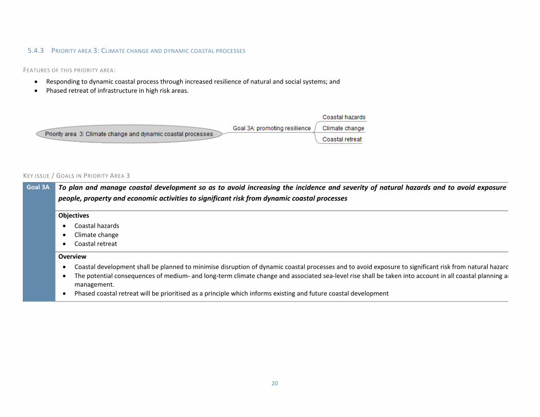
5.4.3 PRIORITY AREA 3: CLIMATE CHANGE AND DYNAMIC COASTAL PROCESSES
FEATURES OF THIS PRIORITY AREA:
Responding to dynamic coastal process through increased resilience of natural and social systems; and Phased retreat of infrastructure in high risk areas.
KEY ISSUE / GOALS IN PRIORITY AREA 3
Goal 3A To plan and manage coastal development so as to avoid increasing the incidence and severity of natural hazards and to avoid exposure people, property and economic activities to significant risk from dynamic coastal processes
Objectives
Coastal hazards Climate change Coastal retreat
Overview
Coastal development shall be planned to minimise disruption of dynamic coastal processes and to avoid exposure to significant risk from natural hazard The potential consequences of medium‐ and long‐term climate change and associated sea‐level rise shall be taken into account in all coastal planning an
management. Phased coastal retreat will be prioritised as a principle which informs existing and future coastal development
21
Easte
rn C
ape C
oasta
l Managem
ent P
rogra
mm
e
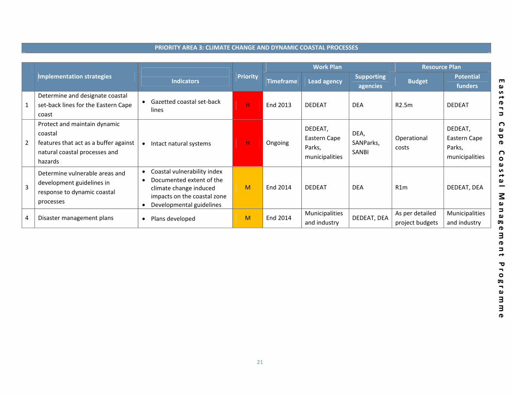
PRIORITY AREA 3: CLIMATE CHANGE AND DYNAMIC COASTAL PROCESSES
Implementation strategies
Indicators
Priority Work Plan Resource Plan
Timeframe Lead agency Supporting agencies
Budget Potential funders
1 Determine and designate coastal set‐back lines for the Eastern Cape coast
Gazetted coastal set‐back lines
H End 2013 DEDEAT DEA R2.5m DEDEAT
2
Protect and maintain dynamic coastal features that act as a buffer against natural coastal processes and hazards
Intact natural systems H Ongoing
DEDEAT, Eastern Cape Parks, municipalities
DEA, SANParks, SANBI
Operational costs
DEDEAT, Eastern Cape Parks, municipalities
3
Determine vulnerable areas and development guidelines in response to dynamic coastal processes
Coastal vulnerability index Documented extent of the
climate change induced impacts on the coastal zone
Developmental guidelines
M End 2014 DEDEAT DEA R1m DEDEAT, DEA
4 Disaster management plans Plans developed M End 2014 Municipalities and industry
DEDEAT, DEA As per detailed project budgets
Municipalities and industry
22
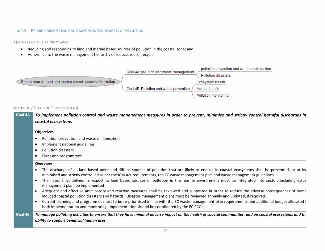
5.4.4 PRIORITY AREA 4: LAND AND MARINE‐BASED SOURCES OF POLLUTION
FEATURES OF THIS PRIORITY AREA:
Reducing and responding to land and marine based sources of pollution in the coastal zone; and Adherence to the waste management hierarchy of reduce, reuse, recycle.
KEY ISSUE / GOALS IN PRIORITY AREA 4
Goal 4A To implement pollution control and waste management measures in order to prevent, minimise and strictly control harmful discharges incoastal ecosystems
Objectives
Pollution prevention and waste minimisation Implement national guidelines Pollution disasters Plans and programmes
Overview
The discharge of all land‐based point and diffuse sources of pollution that are likely to end up in coastal ecosystems shall be prevented, or at leaminimised and strictly controlled as per the ICM Act requirements, the EC waste management plan and waste management guidelines.
The national guidelines in respect to land based sources of pollution in the marine environment must be integrated into sector, including estuamanagement plan, be implemented
Adequate and effective anticipatory and reactive measures shall be reviewed and supported in order to reduce the adverse consequences of humainduced coastal pollution disasters and hazards. Disaster management plans must be reviewed annually and updated, if required.
Current planning and programmes must to be re‐prioritised in line with the EC waste management plan requirements and additional budget allocated fboth implementation and monitoring. Implementation should be coordinated by the EC PCC.
Goal 4B To manage polluting activities to ensure that they have minimal adverse impact on the health of coastal communities, and on coastal ecosystems and theability to support beneficial human uses

23
Easte
rn C
ape C
oasta
l Managem
ent P
rogra
mm
e
Objectives
Ecosystem health Human health Pollution monitoring
Overview
Pollution‐control and waste‐management measures, as detailed in the Eastern Cape Waste Management Plan, shall be implemented to ensure that discharges of organic and bio‐degradable substances are minimal, and that the assimilative capacity of coastal ecosystems is not exceeded.
The discharge of pollutants and waste into coastal ecosystems shall not be allowed to reach levels that adversely affect human health, use and enjoyment of coast and should take cognisance of any coastal management objectives set.
Pollution monitoring must be improved in all sectors of the coastal zone.
PRIORITY AREA 4: LAND AND MARINE BASED SOURCES OF POLLUTION
Implementation strategies
Indicators
Priority Work Plan Resource Plan
Timeframe Lead agency Supporting agencies
Budget Potential funders
1
Ensure that new developments carry out necessary preventative measures to minimise the chances and effects of pollution events
Pollution specific conditions incorporated into coastal development approvals
M Ongoing DEDEAT DWA, DEA Operational costs
DEDEAT
2 Working for the Coast waste clean‐up programmes should be sustained
Ongoing WFTC initiatives M Ongoing DEA DEDEAT, municipalities, EC Parks
DEA programme costs
DEA
3
Design an integrated pollution monitoring system for the coast, based on existing monitoring structures and taking into account the integrated estuarine monitoring programme
Development of pollution monitoring system
Implement Adopt a Beach programme
Integration & coordination of monitoring activities
M Ongoing DEDEAT DEA, SANBI, municipalities, DWA, EC Parks
R150 000 for system
DEDEAT
4 Establish coastal water quality objectives
Development of coastal water quality objectives
M End 2014 DEA, municipalities
DEDEAT, DWA As per municipality needs
DEA
24
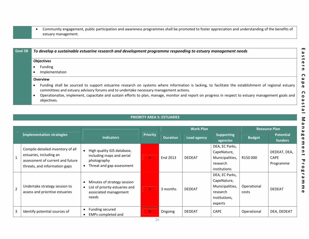
5.4.5 PRIORITY AREA 5: ESTUARIES
FEATURES OF THIS PRIORITY AREA:
Establishing and implementing a strategy to improve the management and protection of estuarine resources; and Securing sufficient financial resources to fund and implement identified actions, research projects, initiatives, and advisory forums.
KEY ISSUE / GOALS IN PRIORITY AREA 5
Goal 5A To manage and protect estuarine resources
Objectives
Prioritisation Estuary Management Plans Protected areas Monitoring Social engagement and awareness
Overview
Estuaries shall be assessed and prioritized for development of estuary management plans, urgent conservation, rehabilitation and other management interventions including detailed ecological water requirement studies.
An estuary management plan shall be developed and implemented for each estuary according to the National Estuarine Management Protocol beginninwith priority estuarine systems, and all estuary management plans shall be incorporated into coastal development planning (EMF, SEA, IDP, SDF etc) in order to prevent degradation of ecosystem health and functionality, loss of biodiversity and provision of ecosystem goods and services.
An adequate estuarine protected area system shall be established comprising unique and healthy estuaries, to conserve different typologies, habitats, species, populations and landscape processes as per the requirements of CAPE Estuaries Conservation Plan.
Estuarine research and monitoring shall be improved to track the health status, pollution levels, utilisation and outcomes of management actions and should form part of estuary management plans.
25
Easte
rn C
ape C
oasta
l Managem
ent P
rogra
mm
e
Community engagement, public participation and awareness programmes shall be promoted to foster appreciation and understanding of the benefits of estuary management.
Goal 5B To develop a sustainable estuarine research and development programme responding to estuary management needs
Objectives
Funding Implementation
Overview
Funding shall be sourced to support estuarine research on systems where information is lacking, to facilitate the establishment of regional estuary committees and estuary advisory forums and to undertake necessary management actions.
Operationalize, implement, capacitate and sustain efforts to plan, manage, monitor and report on progress in respect to estuary management goals and objectives.
PRIORITY AREA 5: ESTUARIES
Implementation strategies
Indicators Priority
Work Plan Resource Plan
Duration Lead agency Supporting agencies
Budget Potential funders
1
Compile detailed inventory of all estuaries, including an assessment of current and future threats, and information gaps
High quality GIS database, including maps and aerial photography
Threat and gap assessment
H End 2013 DEDEAT
DEA, EC Parks, CapeNature, Municipalities, research institutions
R150 000 DEDEAT, DEA, CAPE Programme
2 Undertake strategy session to assess and prioritise estuaries
Minutes of strategy session List of priority estuaries and
associated management needs
H 3 months DEDEAT
DEA, EC Parks, CapeNature, Municipalities, research institutions, experts
Operational costs
DEDEAT
3 Identify potential sources of Funding secured EMPs completed and
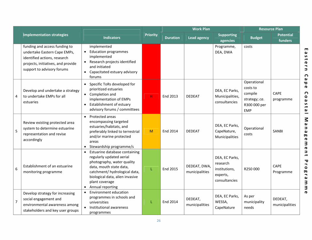
H Ongoing DEDEAT CAPE Operational DEA, DEDEAT
26
Easte
rn C
ape C
oasta
l Managem
ent P
rogra
mm
e
Implementation strategies
Indicators Priority
Work Plan Resource Plan
Duration Lead agency Supporting agencies
Budget Potential funders
funding and access funding to undertake Eastern Cape EMPs, identified actions, research projects, initiatives, and provide support to advisory forums
implemented Education programmes
implemented Research projects identified
and initiated Capacitated estuary advisory
forums
Programme, DEA, DWA
costs
4 Develop and undertake a strategy to undertake EMPs for all estuaries
Specific ToRs developed for prioritized estuaries
Completion and implementation of EMPs
Establishment of estuary advisory forums / committees
H End 2013 DEDEAT DEA, EC Parks, Municipalities, consultancies
Operational costs to compile strategy; ca. R300 000 per EMP
CAPE programme
5
Review existing protected area system to determine estuarine representation and revise accordingly
Protected areas encompassing targeted estuaries/habitats, and preferably linked to terrestrial and/or marine protected areas
Stewardship programme/s
M End 2014 DEDEAT DEA, EC Parks, CapeNature, Municipalities
Operational costs
SANBI
6 Establishment of an estuarine monitoring programme
Estuarine database containing regularly updated aerial photography, water quality data, mouth state data, catchment/ hydrological data, biological data, alien invasive plant coverage
Annual reporting
L End 2015 DEDEAT, DWA, municipalities
DEA, EC Parks, research institutions, experts, consultancies
R250 000 CAPE Programme
7
Develop strategy for increasing social engagement and environmental awareness among stakeholders and key user groups
Environment education programmes in schools and universities
Institutional awareness programmes
L End 2014 DEDEAT, municipalities
DEA, EC Parks, WESSA, CapeNature
As per municipality needs
DEDEAT, municipalities
27
Easte
rn C
ape C
oasta
l Managem
ent P
rogra
mm
e
Implementation strategies
Indicators Priority
Work Plan Resource Plan
Duration Lead agency Supporting agencies
Budget Potential funders
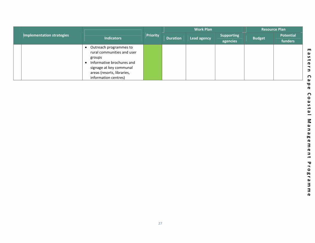
Outreach programmes to rural communities and user groups
Informative brochures and signage at key communal areas (resorts, libraries, information centres)

28
5.4.6 PRIORITY AREA 6: THE FACILITATION OF COASTAL ACCESS
FEATURES OF THIS PRIORITY AREA:
Promoting and managing access to coastal public property; Promoting and facilitating equitable access to coastal resources and coastal public property; Recognising the importance of access preservation; and Promoting custodianship and stewardship of the coastal zone.
KEY ISSUE / GOALS IN PRIORITY AREA 6
Goal 6A To ensure that the public has the right of physical access to the sea, and to and along the sea shore, on a managed basis
Objectives
Opportunities for public access Managing public access
Overview
Opportunities for public access shall be provided at appropriate coastal locations, and improved where necessary, as per the ICM Act requirements. Where appropriate, public access shall be managed (planned, mapped, controlled or consolidated) to minimise adverse impacts and to resolve
incompatible uses.
29
Easte
rn C
ape C
oasta
l Managem
ent P
rogra
mm
e
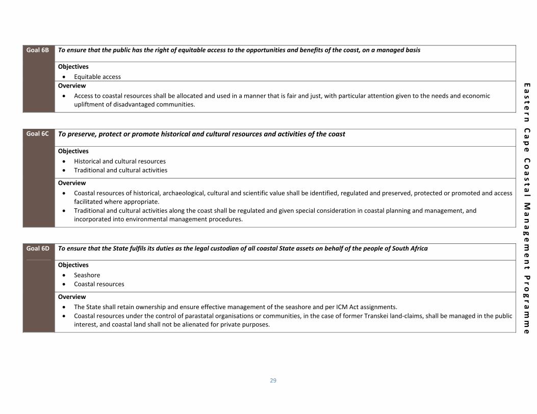
Goal 6B To ensure that the public has the right of equitable access to the opportunities and benefits of the coast, on a managed basis
Objectives
Equitable access Overview
Access to coastal resources shall be allocated and used in a manner that is fair and just, with particular attention given to the needs and economic upliftment of disadvantaged communities.
Goal 6C To preserve, protect or promote historical and cultural resources and activities of the coast
Objectives
Historical and cultural resources Traditional and cultural activities
Overview
Coastal resources of historical, archaeological, cultural and scientific value shall be identified, regulated and preserved, protected or promoted and access facilitated where appropriate.
Traditional and cultural activities along the coast shall be regulated and given special consideration in coastal planning and management, and incorporated into environmental management procedures.
Goal 6D To ensure that the State fulfils its duties as the legal custodian of all coastal State assets on behalf of the people of South Africa
Objectives
Seashore Coastal resources
Overview
The State shall retain ownership and ensure effective management of the seashore and per ICM Act assignments. Coastal resources under the control of parastatal organisations or communities, in the case of former Transkei land‐claims, shall be managed in the public
interest, and coastal land shall not be alienated for private purposes.
30
Easte
rn C
ape C
oasta
l Managem
ent P
rogra
mm
e
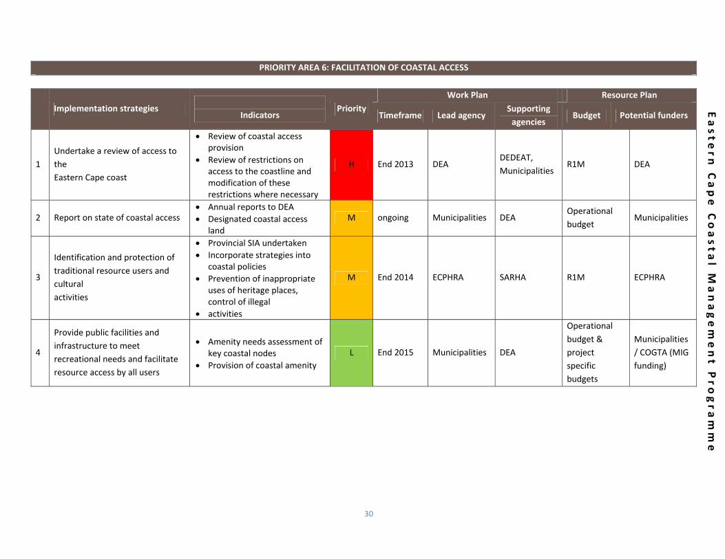
PRIORITY AREA 6: FACILITATION OF COASTAL ACCESS
Implementation strategies
Indicators
Priority Work Plan Resource Plan
Timeframe Lead agency Supporting agencies
Budget Potential funders
1 Undertake a review of access to the Eastern Cape coast
Review of coastal access provision
Review of restrictions on access to the coastline and modification of these restrictions where necessary
H End 2013 DEA DEDEAT, Municipalities
R1M DEA
2 Report on state of coastal access Annual reports to DEA Designated coastal access
land M ongoing Municipalities DEA
Operational budget
Municipalities
3
Identification and protection of traditional resource users and cultural activities
Provincial SIA undertaken Incorporate strategies into
coastal policies Prevention of inappropriate
uses of heritage places, control of illegal
activities
M End 2014 ECPHRA SARHA R1M ECPHRA
4
Provide public facilities and infrastructure to meet recreational needs and facilitate resource access by all users
Amenity needs assessment of key coastal nodes
Provision of coastal amenity L End 2015 Municipalities DEA
Operational budget & project specific budgets
Municipalities / COGTA (MIG funding)

31
5.4.7 PRIORITY AREA 7: AWARENESS, EDUCATION, TRAINING, CAPACITY BUILDING AND INFORMATION
FEATURES OF THIS PRIORITY AREA:
Facilitation of knowledge production and exchange; Promotion of knowledge sharing of coastal issues; and Instilling a sense of ownership of the coastal zone amongst all stakeholders.
KEY ISSUE / GOALS IN PRIORITY AREA 7
Goal 7A To promote public awareness about the coast and educate and train coastal managers and other stakeholders to ensure more effecticoastal planning and management
Objectives
Public awareness Education and training
Overview
The EC coastal‐awareness and education programme must compliment the National programme, be sensitive to regional and local needs and reportedto via the Eastern Cape Environmental Empowerment Services. As well as include a proactive outreach and communication plan.
Education and training programmes for all relevant officials, stakeholders and communities shall be developed and implemented and reported on.
Goal 7B To promote effective, accessible and co‐ordinated research, spatial planning as well as access to information
Objectives
Research Information system

32
Easte
rn C
ape C
oasta
l Managem
ent P
rogra
mm
e
Information exchange
Overview
The integrity of species, habitats and the productivity of coastal ecosystems, the impacts of future development and population growth as well as climate change must be researched.
An effective, accessible and co‐ordinated integrated spatial planning system must be designed and maintained to support coastal planning and management efforts in the Eastern Cape.
Adequate information exchange and dissemination must be ensured between scientists, coastal managers and all relevant stakeholders.
Goal 7C To instil a sense of ownership of the coast by communities and a recognition of its intrinsic value to the Eastern Cape
Objectives
Sense of ownership Stewardship programmes Annual events
Overview
Public awareness programmes, education and equitable access to resources should lead to the appreciation of a sense of ownership of the coast and recognition of its intrinsic value to the Eastern Cape.
Stewardship programmes should be encouraged and regulated to ensure a sense of ownership and shared responsibility of the coastal zone Opportunities created by annual events, such as the annual sardine run, must be capitalised upon to improve ICM awareness
PRIORITY AREA 8: AWARENESS, EDUCATION, TRAINING, CAPACITY BUILDING AND INFORMATION
Implementation strategies
Indicators
Priority Work Plan Resource Plan
Timeframe Lead agency Supporting agencies
Budget Potential funders
1
Develop and implement a training and capacity building programme for coastal managers/ officials and councillors
Workshops attended Feedback from
implementation efforts H End 2013 DEA DEDEAT
National programme budget
DEA
2 Coastal spatial data to be collected on a regular basis
Aerial surveys undertaken Remote sensing undertaken Lidar surveys undertaken
M ongoing DEA, SG DEDEAT As per project specific costing
DEA, SG
33
Easte
rn C
ape C
oasta
l Managem
ent P
rogra
mm
e
Implementation strategies
Indicators Priority
Work Plan Resource Plan
Timeframe Lead agency Supporting agencies
Budget Potential funders
3 Identify and facilitate an effective network of environmental learning centres
Operational network Effective sharing of
information Co‐ordinated research
initiatives
M End 2014 SANCOR, CSIR Universities, DEDEAT, DST
Operational costs
DST
4 Improve ecosystem functioning through education and public awareness programmes
Education and public awareness raising programme developed and implemented
L End 2015 DEDEAT, EC Department of Education
DEA R200 000 per annum
DEDEAT, EC Department of Education, DEA

34
5.4.8 PRIORITY AREA 8: COMPLIANCE, MONITORING AND ENFORCEMENT
FEATURES OF THIS PRIORITY AREA:
Facilitation of compliance with applicable coastal legislation; and Promotion of the environmental management inspectorate and facilitation of environmental management inspectors.
KEY ISSUE / GOALS IN PRIORITY AREA 8
Goal 8A To promote compliance with coastal and other relevant regulations
Objectives
Compliance EMI’s Priority projects
Overview
Compliance with coastal and other applicable regulations must be encouraged and improved. Designation and specialised training of EMIs within provincial and local government must be supported and adequate human and capital resources
ensured. Current and future EC priority projects, for example the wild coast illegal cottages project, should be supported and enforcement task teams established
to ensure their implementation
35
Easte
rn C
ape C
oasta
l Managem
ent P
rogra
mm
e
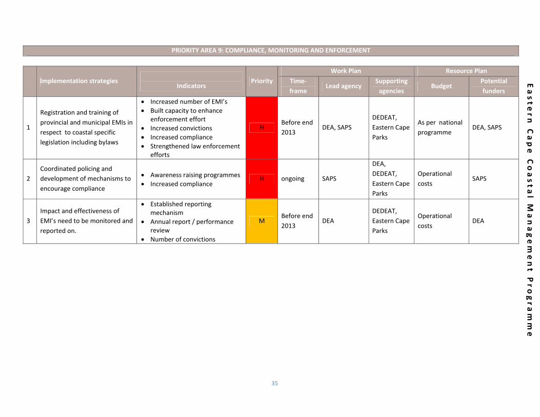
PRIORITY AREA 9: COMPLIANCE, MONITORING AND ENFORCEMENT
Implementation strategies
Indicators
Priority Work Plan Resource Plan
Time‐frame
Lead agency Supporting agencies
Budget Potential funders
1
Registration and training of provincial and municipal EMIs in respect to coastal specific legislation including bylaws
Increased number of EMI’s Built capacity to enhance
enforcement effort Increased convictions Increased compliance Strengthened law enforcement
efforts
H Before end 2013
DEA, SAPS DEDEAT, Eastern Cape Parks
As per national programme
DEA, SAPS
2 Coordinated policing and development of mechanisms to encourage compliance
Awareness raising programmes Increased compliance
H ongoing SAPS
DEA, DEDEAT, Eastern Cape Parks
Operational costs
SAPS
3 Impact and effectiveness of EMI’s need to be monitored and reported on.
Established reporting mechanism
Annual report / performance review
Number of convictions
M Before end 2013
DEA DEDEAT, Eastern Cape Parks
Operational costs
DEA

36
5.4.9 PRIORITY AREA 9: NATURAL RESOURCE MANAGEMENT
FEATURES OF THIS PRIORITY AREA:
The maintencance of ecosystem integrity and health; To assess and effectively manage coastal protected areas , inlcuding marine protected areas; and To identify and rehabilitate damaged and degraded coastal ecosystems and habitats.
KEY ISSUE / GOALS IN PRIORITY AREA 9
Goal 9A To maintain the diversity, health, and productivity of coastal processes and ecosystems
Objectives
Ecosystem health Overview The biological diversity, natural functioning and ecological integrity, health and productivity of coastal ecosystems shall be maintained as per the requiremenof the Eastern Cape Biodiversity Conservation Plan and other plans (SDFs, EMFs and other coastal plans)
Goal 9B To establish and effectively manage a system of coastal protected areas
Objectives
Coastal protected areas Integration
Overview
An adequate system of protected areas and special areas shall be established and managed to represent all coastal ecosystems, to restore and maintainthe diversity, health and productivity of coastal ecosystems, habitats and species (as per the requirements of the EC protected area expansion strategy)
Coastal protected areas shall be integrated across both the land and sea, where practical.
37
Easte
rn C
ape C
oasta
l Managem
ent P
rogra
mm
e
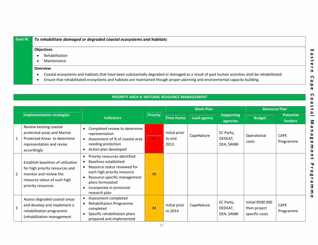
Goal 9C To rehabilitate damaged or degraded coastal ecosystems and habitats
Objectives
Rehabilitation Maintenance
Overview
Coastal ecosystems and habitats that have been substantially degraded or damaged as a result of past human activities shall be rehabilitated. Ensure that rehabilitated ecosystems and habitats are maintained though proper planning and environmental capacity building.
PRIORITY AREA 9: NATURAL RESOURCE MANAGEMENT
Implementation strategies
Indicators
Priority Work Plan Resource Plan
Time frame Lead agency Supporting agencies
Budget Potential funders
1
Review existing coastal protected areas and Marine Protected Areas to determine representation and revise accordingly
Completed review to determine representation
Assessment of % of coastal area needing protection
Action plan developed
H Initial prior to end 2013
CapeNature
EC Parks, DEDEAT, DEA, SANBI
Operational costs
CAPE Programme
2
Establish baselines of utilisation for high priority resources and monitor and review the resource status of such high priority resources
Priority resources identified Baselines established Resource status reviewed for
each high priority resource Resource‐specific management
plans formulated Incorporate in provincial
research plan
M
3
Assess degraded coastal areas and develop and implement a rehabilitation programme (rehabilitation management
Assessment completed Rehabilitation Programme
completed Specific rehabilitation plans
prepared and implemented
M Initial prior to 2014
CapeNature
EC Parks, DEDEAT, DEA, SANBI
Initial R500 000 then project specific costs
CAPE Programme
38
Easte
rn C
ape C
oasta
l Managem
ent P
rogra
mm
e
Implementation strategies
Indicators Priority
Work Plan Resource Plan
Time frame Lead agency Supporting agencies
Budget Potential funders
plans)
4
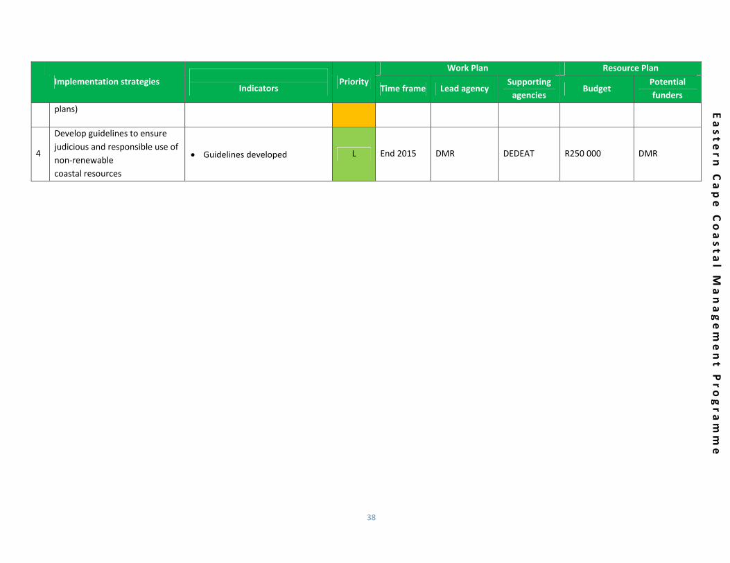
Develop guidelines to ensure judicious and responsible use of non‐renewable coastal resources
Guidelines developed L End 2015 DMR DEDEAT R250 000 DMR

39
Easte
rn C
ape C
oasta
l Managem
ent P
rogra
mm
e
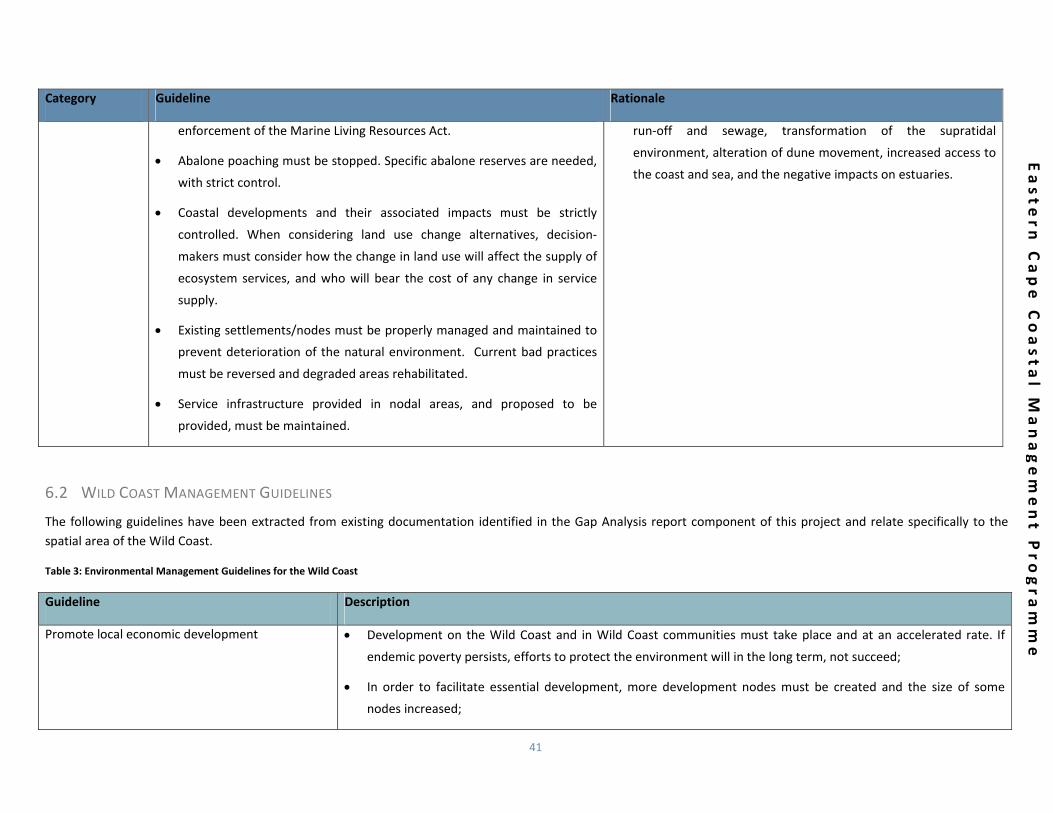
6 NORMS AND STANDARDS FOR THE EASTERN CAPE COASTAL ZONE Norms are management practices that are regarded as typical or best practice. Standards are management rules and guiding principles to achieve certain objectives or outcomes, or to ensure legal compliance. For the purposes of the Eastern Cape CMP, norms take the form of environmental management guidelines, both with reference to specific areas, and guidelines that are more generic. These guidelines have been derived from the gap analysis report as well as from the 2004 CMP and include both existing and proposed guidelines.
Standards for the Eastern Cape CMP are proposed for coastal set‐back line demarcation and establishment.
6.1 GENERAL ENVIRONMENTAL MANAGEMENT GUIDELINES FOR THE EASTERN CAPE COAST
The following guidelines have been extracted from existing documentation identified in the Gap Analysis report component of this project.
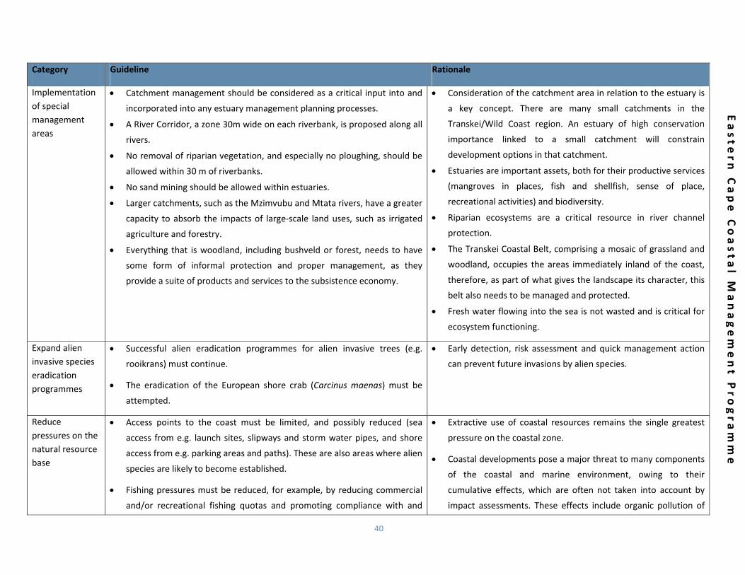
Table 2: General Environmental Management Guidelines for the Eastern Cape Coast
Category Guideline Rationale
Consolidation and expansion of protected areas
Land use planning must be aligned with national policy so that national
conservation targets for different natural asset types are adhered to,
namely a target of 30% of estuaries conserved.
All natural forests should have a high degree of protection, but will be
more difficult to attain, since so many of the existing forests are in a poor
state.
If a municipality is endowed with conservation assets of high value, then
land uses that support and add value to the assets rather than detract
from them, should be promoted.
Formal conservation areas should be consolidated and new developments
should be concentrated where there is already development.
Conservation of biodiversity assets are identified in this strategy as of
critical importance if sustainability is to become a defining feature of
coastal management in the Eastern Cape, but true sustainability means
making allowances for communities to benefit from conservation
initiatives.
Opportunities exist to secure South Africa’s marine and coastal
habitats.
South Africa is poised to expand its Marine Protected Area
network.
MPAs are valuable national assets that deliver ecosystem
services and socio‐economic benefit.
Overexploited fish stocks can recover and provide long‐term
food and job security.
40
Easte
rn C
ape C
oasta
l Managem
ent P
rogra
mm
e
Category Guideline Rationale
Implementation of special management areas
Catchment management should be considered as a critical input into and
incorporated into any estuary management planning processes.
A River Corridor, a zone 30m wide on each riverbank, is proposed along all
rivers.
No removal of riparian vegetation, and especially no ploughing, should be
allowed within 30 m of riverbanks.
No sand mining should be allowed within estuaries.
Larger catchments, such as the Mzimvubu and Mtata rivers, have a greater
capacity to absorb the impacts of large‐scale land uses, such as irrigated
agriculture and forestry.
Everything that is woodland, including bushveld or forest, needs to have
some form of informal protection and proper management, as they
provide a suite of products and services to the subsistence economy.
Consideration of the catchment area in relation to the estuary is
a key concept. There are many small catchments in the
Transkei/Wild Coast region. An estuary of high conservation
importance linked to a small catchment will constrain
development options in that catchment.
Estuaries are important assets, both for their productive services
(mangroves in places, fish and shellfish, sense of place,
recreational activities) and biodiversity.
Riparian ecosystems are a critical resource in river channel
protection.
The Transkei Coastal Belt, comprising a mosaic of grassland and
woodland, occupies the areas immediately inland of the coast,
therefore, as part of what gives the landscape its character, this
belt also needs to be managed and protected.
Fresh water flowing into the sea is not wasted and is critical for
ecosystem functioning.
Expand alien invasive species eradication programmes
Successful alien eradication programmes for alien invasive trees (e.g.
rooikrans) must continue.
The eradication of the European shore crab (Carcinus maenas) must be
attempted.
Early detection, risk assessment and quick management action
can prevent future invasions by alien species.
Reduce pressures on the natural resource base
Access points to the coast must be limited, and possibly reduced (sea
access from e.g. launch sites, slipways and storm water pipes, and shore
access from e.g. parking areas and paths). These are also areas where alien
species are likely to become established.
Fishing pressures must be reduced, for example, by reducing commercial
and/or recreational fishing quotas and promoting compliance with and
Extractive use of coastal resources remains the single greatest
pressure on the coastal zone.
Coastal developments pose a major threat to many components
of the coastal and marine environment, owing to their
cumulative effects, which are often not taken into account by
impact assessments. These effects include organic pollution of
41
Easte
rn C
ape C
oasta
l Managem
ent P
rogra
mm
e
Category Guideline Rationale
enforcement of the Marine Living Resources Act.
Abalone poaching must be stopped. Specific abalone reserves are needed,
with strict control.
Coastal developments and their associated impacts must be strictly
controlled. When considering land use change alternatives, decision‐
makers must consider how the change in land use will affect the supply of
ecosystem services, and who will bear the cost of any change in service
supply.
Existing settlements/nodes must be properly managed and maintained to
prevent deterioration of the natural environment. Current bad practices
must be reversed and degraded areas rehabilitated.
Service infrastructure provided in nodal areas, and proposed to be
provided, must be maintained.
run‐off and sewage, transformation of the supratidal
environment, alteration of dune movement, increased access to
the coast and sea, and the negative impacts on estuaries.
6.2 WILD COAST MANAGEMENT GUIDELINES
The following guidelines have been extracted from existing documentation identified in the Gap Analysis report component of this project and relate specifically to the spatial area of the Wild Coast.
Table 3: Environmental Management Guidelines for the Wild Coast
Guideline Description
Promote local economic development Development on the Wild Coast and in Wild Coast communities must take place and at an accelerated rate. If
endemic poverty persists, efforts to protect the environment will in the long term, not succeed;
In order to facilitate essential development, more development nodes must be created and the size of some
nodes increased;
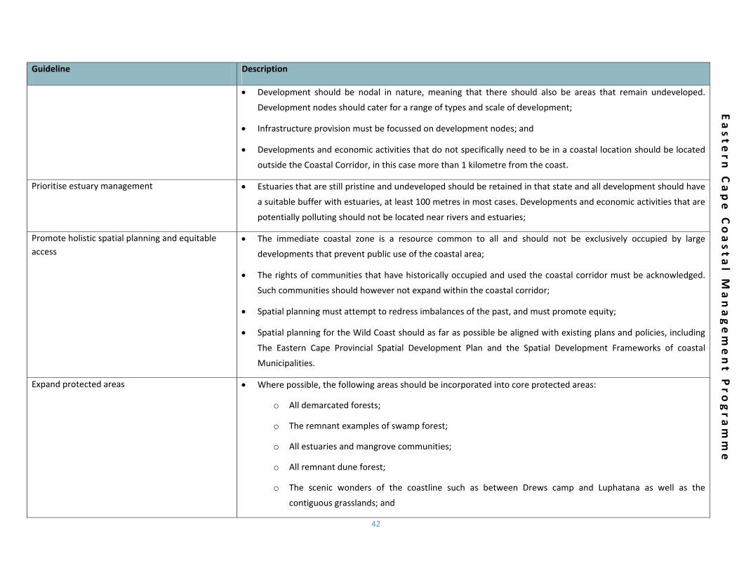
42
Easte
rn C
ape C
oasta
l Managem
ent P
rogra
mm
e
Guideline Description
Development should be nodal in nature, meaning that there should also be areas that remain undeveloped.
Development nodes should cater for a range of types and scale of development;
Infrastructure provision must be focussed on development nodes; and
Developments and economic activities that do not specifically need to be in a coastal location should be located
outside the Coastal Corridor, in this case more than 1 kilometre from the coast.
Prioritise estuary management Estuaries that are still pristine and undeveloped should be retained in that state and all development should have
a suitable buffer with estuaries, at least 100 metres in most cases. Developments and economic activities that are
potentially polluting should not be located near rivers and estuaries;
Promote holistic spatial planning and equitable access
The immediate coastal zone is a resource common to all and should not be exclusively occupied by large
developments that prevent public use of the coastal area;
The rights of communities that have historically occupied and used the coastal corridor must be acknowledged.
Such communities should however not expand within the coastal corridor;
Spatial planning must attempt to redress imbalances of the past, and must promote equity;
Spatial planning for the Wild Coast should as far as possible be aligned with existing plans and policies, including
The Eastern Cape Provincial Spatial Development Plan and the Spatial Development Frameworks of coastal
Municipalities.
Expand protected areas Where possible, the following areas should be incorporated into core protected areas:
o All demarcated forests;
o The remnant examples of swamp forest;
o All estuaries and mangrove communities;
o All remnant dune forest;
o The scenic wonders of the coastline such as between Drews camp and Luphatana as well as the
contiguous grasslands; and

43
Easte
rn C
ape C
oasta
l Managem
ent P
rogra
mm
e
Guideline Description
o The forested river gorges of Msikaba, Mtentu, Sikombe, Nyameni, Mzamba and Umtamvuna.
Existing formal Protected Areas must be expanded and new formal Protected Areas established. In this regard the
targets set in the Presidential Program of Action, and specifically Outcome 10, should be pursued;
Remaining Indigenous Forest on the Wild Coast must be protected and forest clearing of any kind should only be
permitted under exceptional circumstances. Indigenous Forest rehabilitation projects should be strongly
encouraged
44
Easte
rn C
ape C
oasta
l Managem
ent P
rogra
mm
e
6.3 SPECIFIC STANDARDS
The ICM Act mandates provincial CMPs to implement national norms and standards, which are to be defined in the National CMP. At the time of updating, the White Paper for Sustainable Coastal Development (DEAT, 2000) was deemed as the National CMP. Standards within the White Paper were utilised predominantly to inform the priorities and strategies for the implementation component of this document.
With this current ICM cycle the designation of coastal setback lines by provincial lead agents has been identified as a key management and implementation tool aimed at reducing risk and ultimately, achieving sustainable coastal development.
6.3.1 COASTAL SET‐BACK LINE DEMARCATION AND ESTABLISHMENT The establishment of coastal set‐back lines is identified in the ICM Act as a provincial responsibility. In the Eastern Cape, draft coastal set‐back lines have been successfully delineated for the Nelson Mandela Bay Metropolitan Municipality. In keeping with the requirements of the Guide to the Development of CMPs in South Africa (Oceans and Coasts Branch of the Department of Enviornmental Affairs, 2012), methodologies and standards for coastal set‐back line delineation must be undertaken in a manner that promotes consistency and alignment so as to ensure that methodologies and measurement can be easily applied; and allow for skills transfer to existing and new government officials. With this in mind, and considering the set‐back line projects already undertaken, the DEDEAT needs to decide on a preferred methodology for set‐back line delineation and adoption, including the requirements for stakeholder engagement. It is anticipated that the DEA will provide additional direction and guidance in this regard.
Coastal set‐back lines, as detailed in the ICM Act, are prescribed boundaries that indicate the limit of development along ecologically sensitive or vulnerable areas, or an area that poses a hazard or risk to humans (CMPP, 2000). The coastal set‐back line may even be situated outside the coastal zone. The coastal set‐back line prohibits or restricts the construction, extension or repair of structures that are
either wholly or partly seaward of the line. The intention of the coastal set‐back line is to protect or preserve coastal public property; coastal private property; public safety; the coastal protection zone; and the aesthetics of the coastal zone (Celliers, et al. 2009).
While the establishment of coastal set‐back lines is a provincial responsibility, the MEC can only declare set‐back line(s) after consultation with Municipalities and interested and affected parties (I&APs). The MEC must communicate this by publishing regulations in the Gazette. Once determined, this line must be delineated on the map or maps that form part of the municipal zoning scheme. This is done so that the public may determine the position of the set‐back line in relation to existing cadastral boundaries (Celliers, et al. 2009).
The coastal set‐back is proposed to give specific direction in respect to locating the future development footprint and coastal planning schemes will zone the coastline in respect to proposed activities and land use. Effective coastal governance structures should ensure that future decision making is in line with the National Coastal Management Programme (CMP) and its proposed norms and standards to assist decision makers in respect to best practice.
Coastal set‐back lines may be established for various reasons and there may be more than one set‐back line in any given area. For example, one set‐back line may be an anticipated erosion set‐back line, while another may relate to aesthetics and control the height of buildings to protect a specific scenic landscape. Set‐back lines will assist in controlling development along an ecologically sensitive or vulnerable area, or any area that poses a hazard or risk to humans (DEAT, 2000). The ultimate intention of the coastal set‐back line, as defined in the ICM Act, is to protect or preserve:
Coastal public property such as beach amenities and other infrastructure such as parking;
Coastal private property such as private residences and business properties;
Public safety in the face of extreme climate and other natural events;

45
Easte
rn C
ape C
oasta
l Managem
ent P
rogra
mm
e
The coastal protection zone; and
The aesthetics or “sense‐of‐place” of the coastal zone.
7 REVIEW AND AMENDMENT Following endorsement and acceptance of the updated CMP, it is recommended that the next substantive amendment occur five years after publication of this updated CMP, in compliance with the requirements of the ICM Act. It is suggested that ad hoc, minor amendments to the programme be made as and when needed and in consultation with the project steering committee.
8 CONCLUSIONS Managing the uniquely complex and sensitive environments that comprise the coastal zone is a challenging task, requiring strategic objective setting, definitive and implementable goals and ongoing monitoring of indicators to ensure effectiveness and improve efficiency. The Eastern Cape coastal zone is diverse, not only in terms of its natural and social environments, but also in terms of the challenges that it faces, and as such an approach as described above becomes absolutely crucial when striving towards sustainability of coastal settlement and growth. This updated CMP, in conjunction with the 2004 CMP, is intended to function as an integrative planning and policy instrument, and a means to manage the diverse array of activities that occur in the coastal zone without compromising environmental integrity or economic development. Effective implementation of the priority strategies contained in this coastal management programme should make a significant contribution towards the achievement of integrated coastal management in the Eastern Cape.

46
Easte
rn C
ape C
oasta
l Managem
ent P
rogra
mm
e
9 BIBLIOGRAPHY
Arcus Gibb Engineering and Science. (2010). The Eastern Cape State of the
Environment Report 2009. Eastern Cape Department of Economic Development
and Environmental Affairs, East London.
Berliner, D., & Desmet, P. (2007). Eastern Cape Biodiversity Plan Technical Report.
Department of Water Affairs and Forestry Project No 2005‐012, East London.
Celliers, L., Breetzke, T., & Moore, L. R. (2010). A Toolkit for implementing the
Integrated Coastal Management Act. Guideline Document, SSI Engineers and
Environmental Consultants, Durban.
Coastal and Environmental Services. (2011). Eastern Cape Climate Change
Response Strategy. Department of Economic Development and Environmental
Affairs, Bhisho.
Coastal and Environmental Services, EnviroFish Africa, MBB Consulting Engineers
Inc. (2004). The Eastern Cape Coastal Management Programme. Eastern Cape
Department of Economic Affairs, Environment and Tourism, Bhisho.
Department of Environmental Affairs and Tourism. (2001). The Environmental
Potential Atlas (ENPAT) of the National Department of Environmental Affairs and
Tourism, South Africa. Atlas, Department of Environmental Affairs and Tourism,
Pretoria.
Development Management Services. (2005). A Spatial Development Framework
for the Wild Coast. Spatial Development Framework, The Wild Coast Project:
Sustainable Development and Conservation, Durban.
Development Management Services. (2005). A Spatial Development Framework
for the Wild Coast. Wild Coast Project: Conservation and Sustainable
Development, East London.
Development Management Services. (2005). A Spatial Development Framework
for the Wild Coast. Wild Coast Project: Conservation and Sustainabale
Development, East London.
Eastern Cape Department of Economic Development, Environmental Affairs and
Tourism. (2012). Draft Spatial and Environmental Management Guidelines for the
Wild Coast of the Eastern Cape Province. Discussion Document for internal
Government Use, East London.
Eastern Cape Parks. (2009). Eastern Cape Parks Board People and Parks Final
Strategy: 2009‐2011. Two Year Action Plan, East London.
Hinrichsen, D. (1999). The Coastal Population Explosion. In B. Cicin‐Sain, R. W.
Knecht, & N. Foster (Eds.), Trends and Future Challenges for U.S. National Ocean
and Coastal Policy (p. 142). Silver Spring: U.S. Dept. of Commerce, National
Oceanic and Atmospheric Administration.
Naudé, A., Badenhorst, W., Zietsman, L., Van Huyssteen, E., & Maritz, J. (2007).
Geospatial Analysis Platform – Version 2: Technical overview of the mesoframe
methodology and South African Geospatial Analysis Platform. Pretoria: CSIR.
Oceans and Coasts Branch of the Department of Enviornmental Affairs. (2012). A
Guide to the Development of Coastal Management Programmes in South Africa.
Department of Environmental Affairs. Cape Town: Department of Environmental
Affairs.
Reyers, B., & Ginsburg, A. (2005). Conservation Assessment for the Wild Coast.
Wild Coast Conservation and Sustainable Development Project. East London: CSIR
Enviromentek.
Sink, K., Holness, S., Harris, L., Majiedt, P., Atkinson, L., Robinson, T., et al. (2012).
National Biodiversity Assessment 2011: Technical Report Volume 4: Marine and
Coastal Component. South African National Biodiversity Institute. Pretoria: South
African National Biodiversity Institute.

47
Easte
rn C
ape C
oasta
l Managem
ent P
rogra
mm
e
Smith, K., Veranth, J., Kodavanti, U., Aust, A., & Pinkerton, K. (2006). Acute
Pulmonary and Systemic Effects of Inhaled Coal Fly Ash in Rats: Comparison to
Ambient Environmental Particles. Toxocological Sciences , 93 (2), 390‐399.
SRK Consulting. (2006). Strategic Environmental Assessment for the Wild Coast.
The Wilderness Foundation of South Africa. East London: The Wilderness
Foundation of South Africa.
Statistics South Africa. (2012). Census 2011 Statistical release – P0301.4. Pretoria:
Statistics South Africa.
Tshani Consulting cc. (2010). Provincial Spatial Development Plan ‐ Eastern Cape.
The Department of Housing, Local Government and Traditional Affairs. Bhisho:
UN‐Habitat.
Van Niekerk, L., & Turpie, J. (2012). National Biodiversity Assessment 2011:
Technical Report. Volume 3: Estuaries Component. CSIR Report Number
CSIR/NRE/ECOS/ER/2011/0045/B. Stellenbosch: Council for Sicentific Research.
48
Easte
rn C
ape C
oasta
l Managem
ent P
rogra
mm
e
10 APPENDICES
Top Related