


Languages
Pages
Legal


803 Summer Street 803 Summer Street -- First Floor First Floor •• Boston, MA 02127 Boston, MA 02127 T: 617T: 617--275275--0541 0541 •• extext 14051405
76 Dorrance Street 76 Dorrance Street –– Suite 210 Suite 210 •• Providence, RI 02903Providence, RI 02903TT : 401: 401--421421--0541 0541 •• extext 14051405
[email protected]@dgtsurvey.com -- www.dgtsurvey.comwww.dgtsurvey.com
Boston & Providence

Digital Geographic Technologies Inc.Digital Geographic Technologies Inc.presents:presents:
Advanced 3 Dimensional Laser Scanning TechnologyAdvanced 3 Dimensional Laser Scanning Technology““High Definition SurveyingHigh Definition Surveying””
Copyright © 2009 Digital Geographic Technologies, Inc. All Rights Reserved
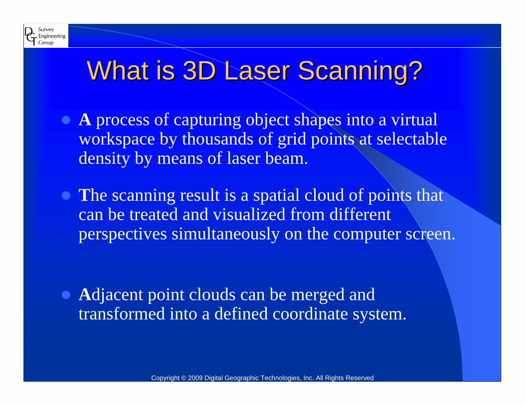
What is 3D Laser Scanning?What is 3D Laser Scanning?
A process of capturing object shapes into a virtual workspace by thousands of grid points at selectable density by means of laser beam.
The scanning result is a spatial cloud of points that can be treated and visualized from different perspectives simultaneously on the computer screen.
Adjacent point clouds can be merged and transformed into a defined coordinate system.
Copyright © 2009 Digital Geographic Technologies, Inc. All Rights Reserved

Capturing/Mapping Object ShapesCapturing/Mapping Object Shapes
Copyright © 2009 Digital Geographic Technologies, Inc. All Rights Reserved

How does 3D Laser Scanning work?How does 3D Laser Scanning work?Vector Sensing TechniqueVector Sensing Technique
1.1. The laser is fired and hits a surfaceThe laser is fired and hits a surface
2.2. Some of the laser light is reflected back towards the scannerSome of the laser light is reflected back towards the scanner
3.3. The scanner detects the return pulseThe scanner detects the return pulse
4.4. The timing electronics determines the amount of time taken The timing electronics determines the amount of time taken by the laser pulse to exit from and return to the systemby the laser pulse to exit from and return to the system
5.5. When combined, the angle of the mirrors and distance to the When combined, the angle of the mirrors and distance to the surface sampled can be converted to a single Cartesian surface sampled can be converted to a single Cartesian (X,Y,Z) point coordinate including intensity value(color and (X,Y,Z) point coordinate including intensity value(color and texture of the object)texture of the object)
Copyright © 2009 Digital Geographic Technologies, Inc. All Rights Reserved

CYRAX 2500CYRAX 2500ClassClass--II (eyeII (eye--safe) safe) –– Green Laser Green Laser
BeamBeam
Field of view:Field of view: 40 x 4040 x 40
Acquisition Rate: Acquisition Rate: 1000 pnts/sec1000 pnts/sec
Max. Range: Max. Range: 100m100m
Single point accuracy: Single point accuracy: +/+/-- 6mm @ 50m6mm @ 50m
Copyright © 2009 Digital Geographic Technologies, Inc. All Rights Reserved

RIEGL LMS 360iRIEGL LMS 360iClassClass--I Laser Beam (eyeI Laser Beam (eye--safe)safe)(invisible by eye (invisible by eye –– traffic safe)traffic safe)
Field of view:Field of view: 90 x 36090 x 360
Acquisition Rate: Acquisition Rate: 8000 pnts/sec8000 pnts/sec
Max. Range:Max. Range: 200m200m
Single point accuracy: Single point accuracy: +/+/-- 6mm @ 100m6mm @ 100m
Copyright © 2009 Digital Geographic Technologies, Inc. All Rights Reserved

Point CloudPoint CloudRiegl LMS 360i ScannerRiegl LMS 360i Scanner
360 degree view 360 degree view -- HorizontalHorizontal
True Color Applied from CameraTrue Color Applied from Camera
Copyright © 2009 Digital Geographic Technologies, Inc. All Rights Reserved
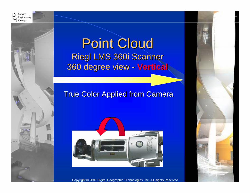
Point CloudPoint CloudRiegl LMS 360i ScannerRiegl LMS 360i Scanner
360 degree view 360 degree view -- VerticalVertical
True Color Applied from CameraTrue Color Applied from Camera
Copyright © 2009 Digital Geographic Technologies, Inc. All Rights Reserved
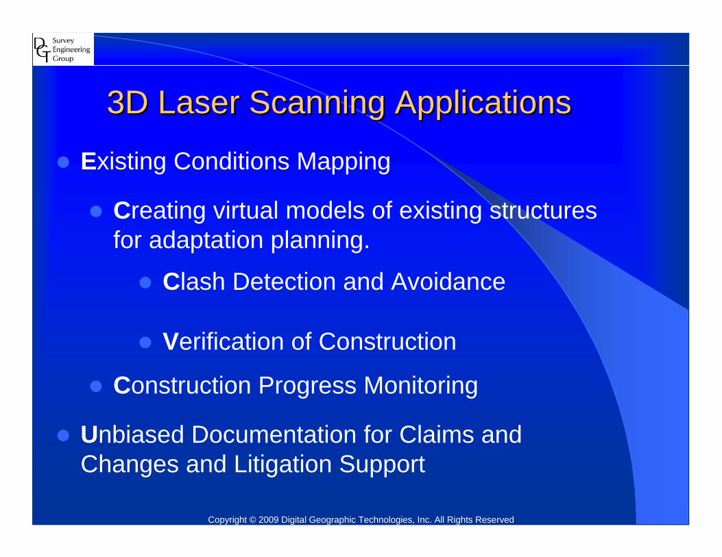
3D Laser Scanning Applications 3D Laser Scanning Applications
Verification of Construction
Creating virtual models of existing structures for adaptation planning.
Existing Conditions Mapping
Unbiased Documentation for Claims and Changes and Litigation Support
Construction Progress Monitoring
Clash Detection and Avoidance
Copyright © 2009 Digital Geographic Technologies, Inc. All Rights Reserved

STATA Center STATA Center -- M.I.T.M.I.T.Monitoring construction progressMonitoring construction progress
Copyright © 2009 Digital Geographic Technologies, Inc. All Rights Reserved

STATA Center STATA Center -- M.I.T.M.I.T.True Color SuperimposedTrue Color Superimposed
Copyright © 2009 Digital Geographic Technologies, Inc. All Rights Reserved

Inaccessibility and Complex Geometry Easily ManagedInaccessibility and Complex Geometry Easily ManagedSTATA Center STATA Center -- M.I.T.M.I.T.
Copyright © 2009 Digital Geographic Technologies, Inc. All Rights Reserved

Benefits of 3D Laser ScanningBenefits of 3D Laser ScanningCaptures thousands of points per second up to 360 deg coverageRemote location of objects:
Inaccessible or dangerous locations– Highways and Traffic intersections– High Voltage Utilities– Structural Steel– Tall structures
Detailed Point Cloud dataThat can be viewed in 3DThat can be dimensioned and modeledThat can be exported to other software platforms.
Rapid and comprehensive 3 dimensional mapping of existing facilities.
Copyright © 2009 Digital Geographic Technologies, Inc. All Rights Reserved

Point Cloud Data Point Cloud Data w/ True Color superimposedw/ True Color superimposed
Copyright © 2009 Digital Geographic Technologies, Inc. All Rights Reserved

Point Cloud Data Point Cloud Data w/ Intensity Colorw/ Intensity Color
Copyright © 2009 Digital Geographic Technologies, Inc. All Rights Reserved

Point Cloud Data Point Cloud Data After CleaningAfter Cleaning
Copyright © 2009 Digital Geographic Technologies, Inc. All Rights Reserved

Point Cloud Data Point Cloud Data w/ Selected Work Areaw/ Selected Work Area
Copyright © 2009 Digital Geographic Technologies, Inc. All Rights Reserved

ModelingModeling
Copyright © 2009 Digital Geographic Technologies, Inc. All Rights Reserved

MeasurementsMeasurements
Copyright © 2009 Digital Geographic Technologies, Inc. All Rights Reserved
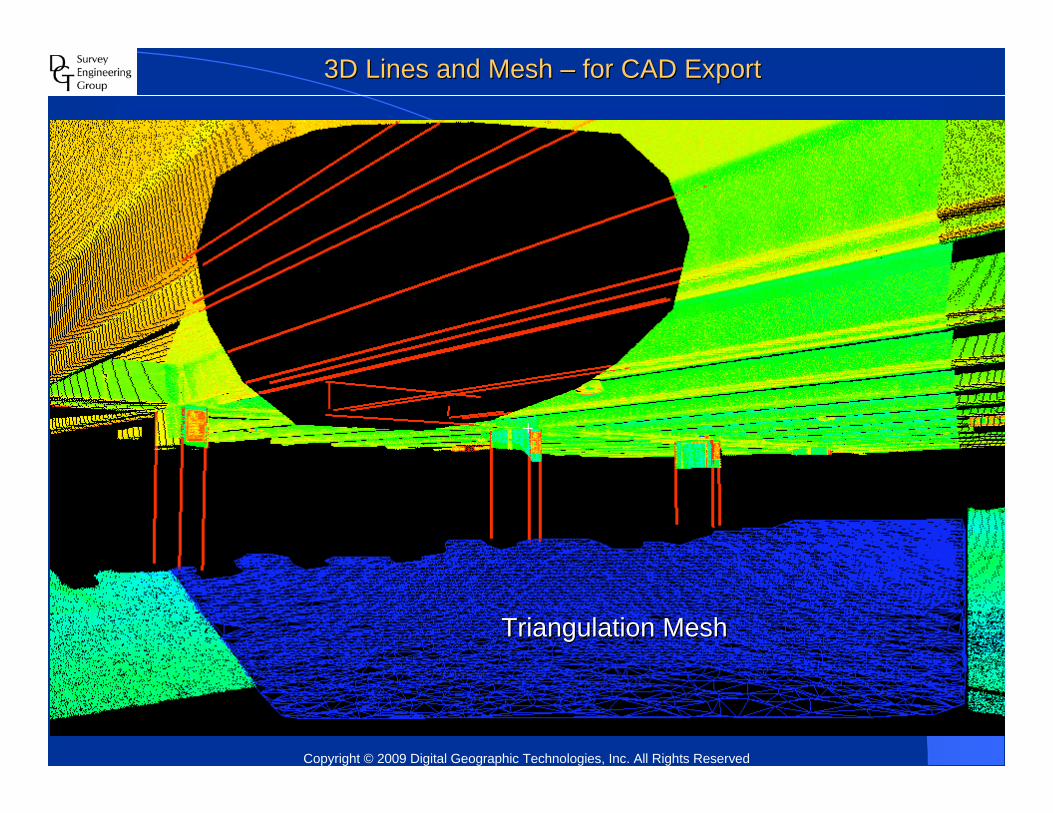
3D Lines and Mesh 3D Lines and Mesh –– for CAD Exportfor CAD Export
Triangulation MeshTriangulation Mesh
Copyright © 2009 Digital Geographic Technologies, Inc. All Rights Reserved
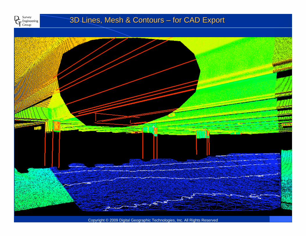
3D Lines, Mesh & Contours 3D Lines, Mesh & Contours –– for CAD Exportfor CAD Export
Copyright © 2009 Digital Geographic Technologies, Inc. All Rights Reserved

Export to AutoCADExport to AutoCADPoint CloudPoint Cloud
AsAs--built Survey built Survey –– Atlantic Avenue, BostonAtlantic Avenue, BostonExhaust Stacks ~ 240Exhaust Stacks ~ 240’’ High from GroundHigh from Ground
Copyright © 2009 Digital Geographic Technologies, Inc. All Rights Reserved
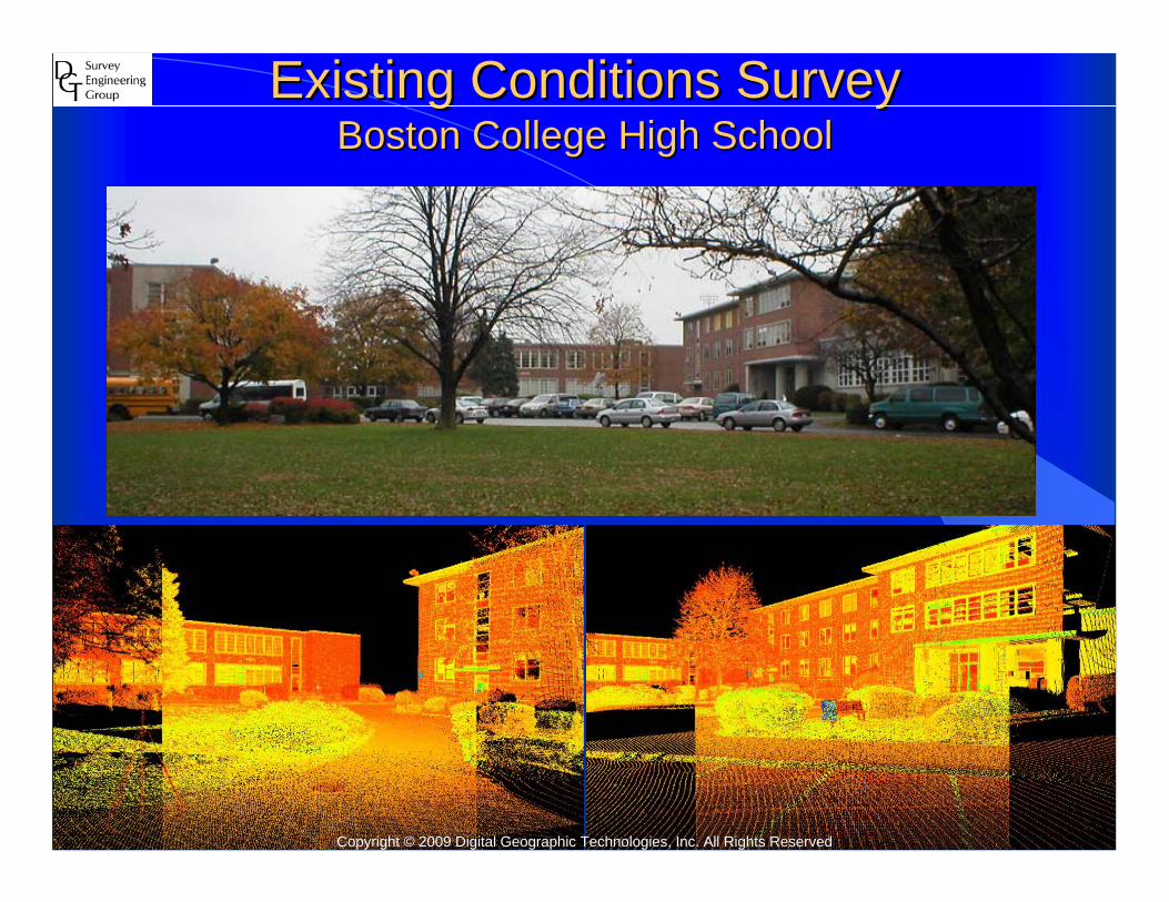
Existing Conditions SurveyExisting Conditions SurveyBoston College High SchoolBoston College High School
Copyright © 2009 Digital Geographic Technologies, Inc. All Rights Reserved
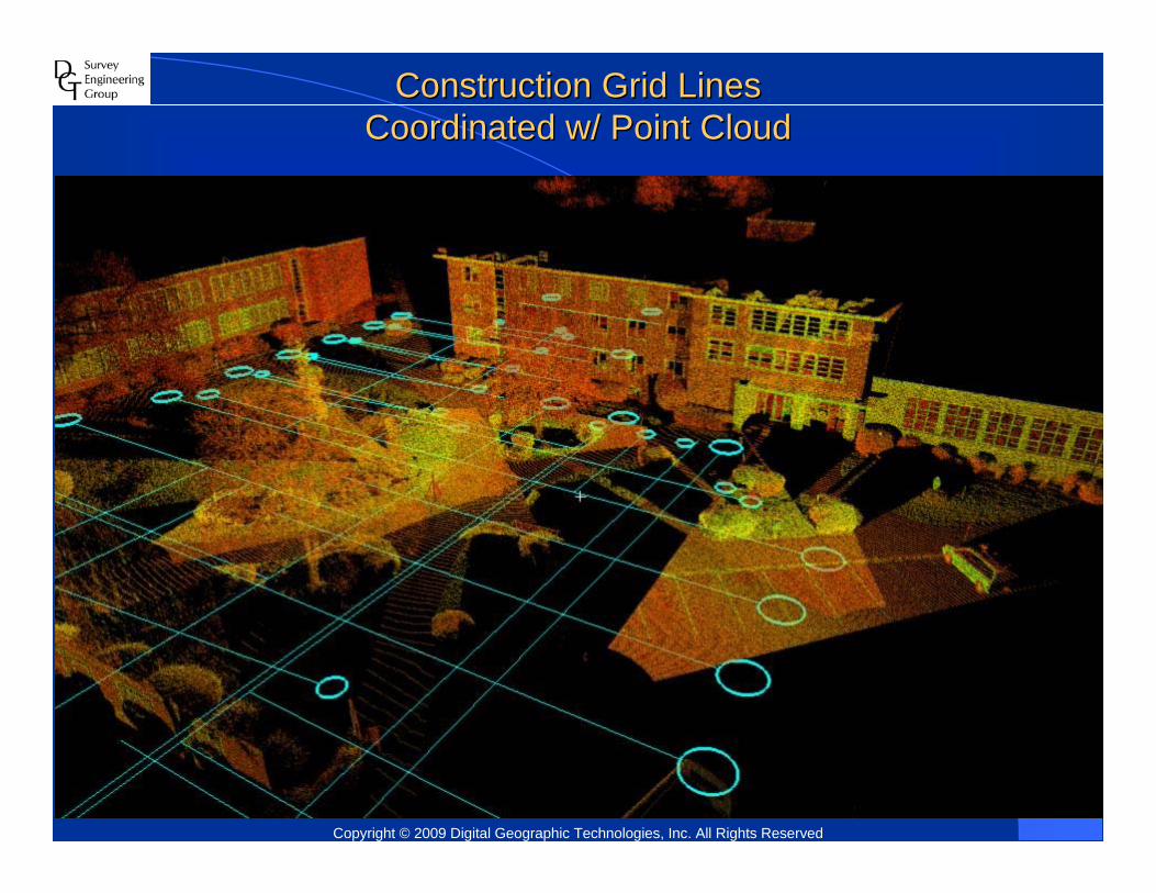
Construction Grid LinesConstruction Grid LinesCoordinated w/ Point CloudCoordinated w/ Point Cloud
Copyright © 2009 Digital Geographic Technologies, Inc. All Rights Reserved

Existing Conditions SurveyExisting Conditions Survey
Boston College High SchoolCopyright © 2009 Digital Geographic Technologies, Inc. All Rights Reserved

Typical Conventional Survey NoteTypical Conventional Survey Note
Copyright © 2009 Digital Geographic Technologies, Inc. All Rights Reserved

Accident Scene SurveyAccident Scene SurveyExisting Wires Existing Wires –– Measurement to GroundMeasurement to Ground
Copyright © 2009 Digital Geographic Technologies, Inc. All Rights Reserved

Accident Scene SurveyAccident Scene SurveyExisting Wires Existing Wires –– Measurement to RoofMeasurement to Roof
Copyright © 2009 Digital Geographic Technologies, Inc. All Rights Reserved

Accident Scene SurveyAccident Scene SurveyExisting Wires Existing Wires –– Plan ViewPlan View
Copyright © 2009 Digital Geographic Technologies, Inc. All Rights Reserved

Accident Scene SurveyAccident Scene SurveyTheoretical Wire Theoretical Wire –– Measurement to GroundMeasurement to Ground
Copyright © 2009 Digital Geographic Technologies, Inc. All Rights Reserved

Accident Scene SurveyAccident Scene SurveyTheoretical Wire Theoretical Wire –– Plan ViewPlan View
Copyright © 2009 Digital Geographic Technologies, Inc. All Rights Reserved

Point Cloud on Project Grid LinesPoint Cloud on Project Grid Lines
Harvard University Harvard University -- BRI ProjectBRI Project
Copyright © 2009 Digital Geographic Technologies, Inc. All Rights Reserved

Point Cloud on Project Grid LinesPoint Cloud on Project Grid Lines
Copyright © 2009 Digital Geographic Technologies, Inc. All Rights Reserved

Point CloudPoint CloudInside Construction ZoneInside Construction Zone
Harvard University Harvard University -- BRI ProjectBRI ProjectCopyright © 2009 Digital Geographic Technologies, Inc. All Rights Reserved

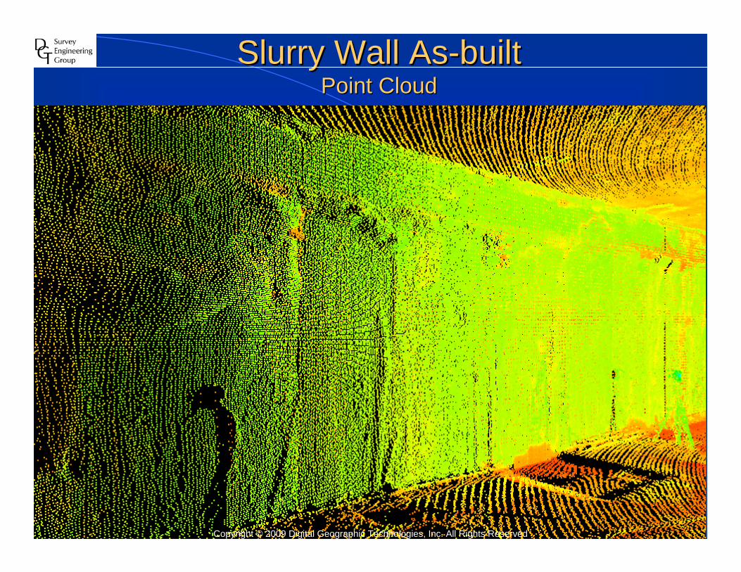
Slurry Wall AsSlurry Wall As--builtbuiltPoint CloudPoint Cloud
Copyright © 2009 Digital Geographic Technologies, Inc. All Rights Reserved

Slurry Wall AsSlurry Wall As--builtbuiltRendered Triangulation MeshRendered Triangulation Mesh
ProtrusionProtrusion
CavityCavity
Harvard University Harvard University -- BRI ProjectBRI ProjectCopyright © 2009 Digital Geographic Technologies, Inc. All Rights Reserved
Slurry Wall AsSlurry Wall As--built built Point CloudPoint Cloud
Copyright © 2009 Digital Geographic Technologies, Inc. All Rights Reserved

Slurry Wall AsSlurry Wall As--built built Rendered Triangulation MeshRendered Triangulation Mesh
Copyright © 2009 Digital Geographic Technologies, Inc. All Rights Reserved

Slurry Wall AsSlurry Wall As--built built Protrusion from Theoretical PlaneProtrusion from Theoretical Plane
Copyright © 2009 Digital Geographic Technologies, Inc. All Rights Reserved
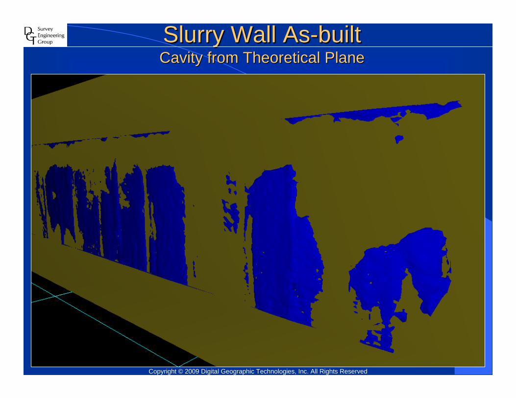
Slurry Wall AsSlurry Wall As--built built Cavity from Theoretical PlaneCavity from Theoretical Plane
Copyright © 2009 Digital Geographic Technologies, Inc. All Rights Reserved

Slurry Wall Surface ContourSlurry Wall Surface ContourProtrusion vs. CavityProtrusion vs. Cavity
Side ViewCopyright © 2009 Digital Geographic Technologies, Inc. All Rights Reserved

Slurry Wall Surface ContourSlurry Wall Surface ContourProtrusion vs. CavityProtrusion vs. Cavity
Plan ViewCopyright © 2009 Digital Geographic Technologies, Inc. All Rights Reserved
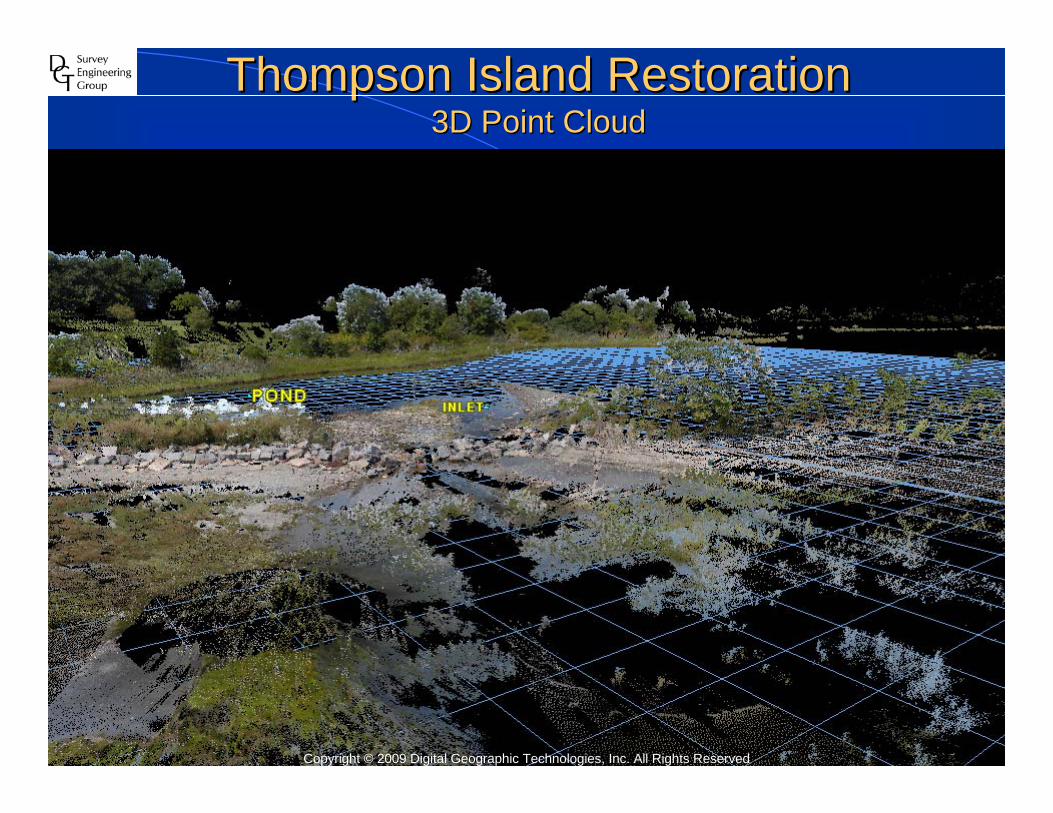
Thompson Island RestorationThompson Island Restoration3D Point Cloud3D Point Cloud
Copyright © 2009 Digital Geographic Technologies, Inc. All Rights Reserved

Thompson Island RestorationThompson Island RestorationTopographic Survey Topographic Survey –– 2D CAD Drawing2D CAD Drawing
Copyright © 2009 Digital Geographic Technologies, Inc. All Rights Reserved
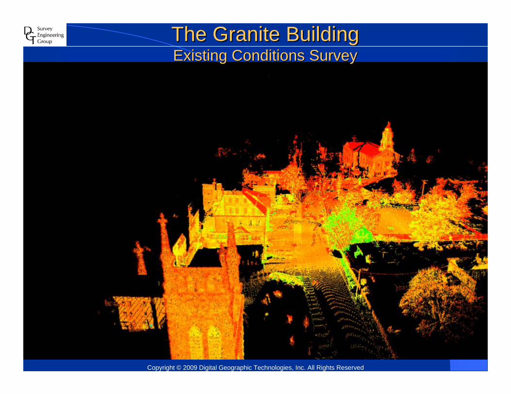
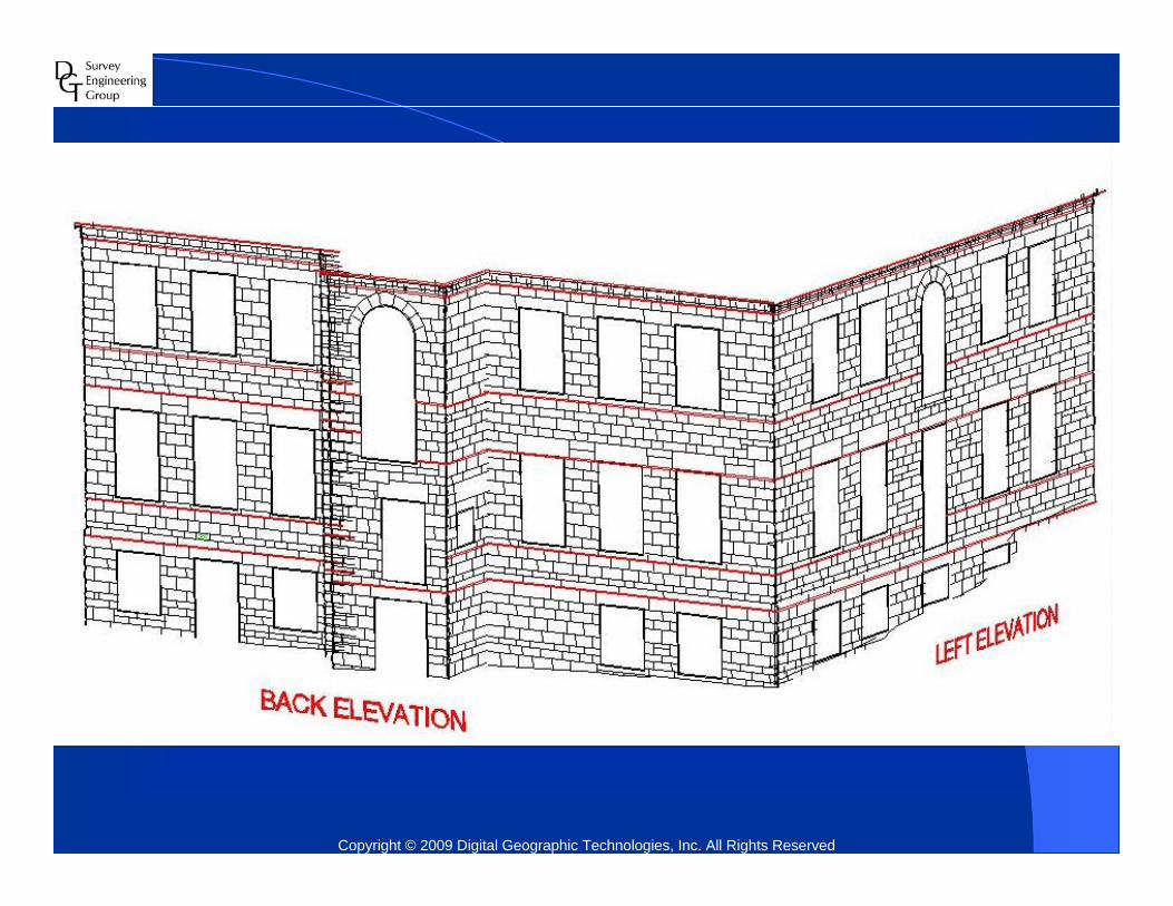
The Granite BuildingThe Granite BuildingExisting Conditions SurveyExisting Conditions Survey
Copyright © 2009 Digital Geographic Technologies, Inc. All Rights Reserved

Copyright © 2009 Digital Geographic Technologies, Inc. All Rights Reserved

Copyright © 2009 Digital Geographic Technologies, Inc. All Rights Reserved

Copyright © 2009 Digital Geographic Technologies, Inc. All Rights Reserved

Copyright © 2009 Digital Geographic Technologies, Inc. All Rights Reserved

Copyright © 2009 Digital Geographic Technologies, Inc. All Rights Reserved
Copyright © 2009 Digital Geographic Technologies, Inc. All Rights Reserved

803 Summer Street 803 Summer Street -- First Floor First Floor •• Boston, MA 02127 Boston, MA 02127 T: 617T: 617--275275--0541 0541 •• extext 14051405
76 Dorrance Street 76 Dorrance Street –– Suite 210 Suite 210 •• Providence, RI 02903Providence, RI 02903TT : 401: 401--421421--0541 0541 •• extext 14051405
[email protected]@dgtsurvey.com -- www.dgtsurvey.comwww.dgtsurvey.com
Boston & Providence
Top Related