TRANSPORTATION IN JAKARTA · (DED) planning consultants and MRTC consultants has been made. • DED...
41
TRANSPORTATION IN JAKARTA July, 2011
Transcript of TRANSPORTATION IN JAKARTA · (DED) planning consultants and MRTC consultants has been made. • DED...
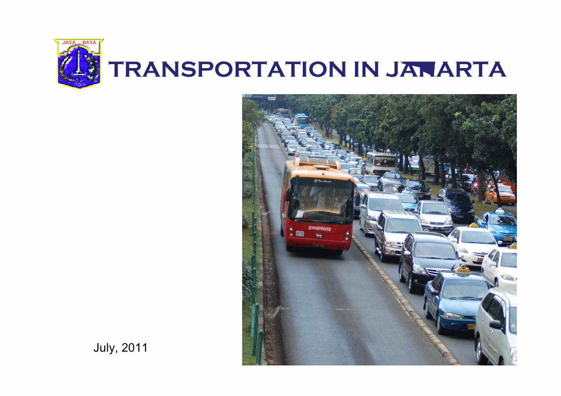
TRANSPORTATION IN JAKARTA
July, 2011
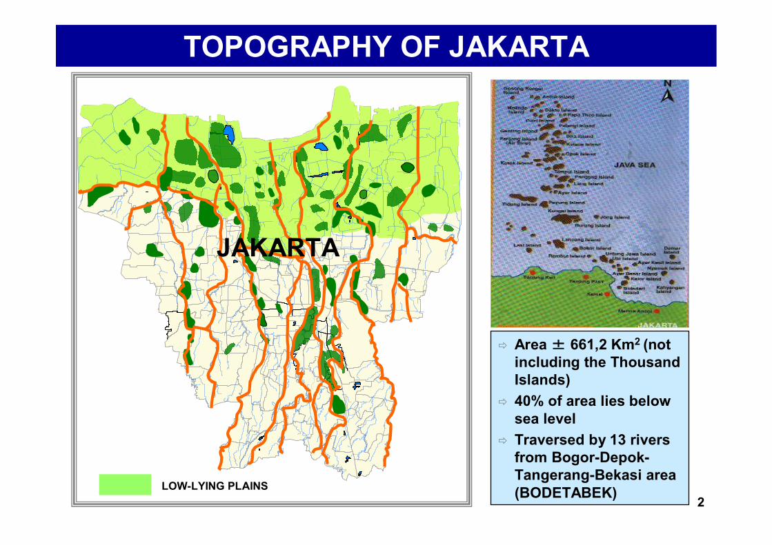
TOPOGRAPHY OF JAKARTA
Area ± 661,2 Km2 (not including the Thousand Islands)
40% of area lies below sea level
Traversed by 13 rivers from Bogor-Depok-Tangerang-Bekasi area (BODETABEK) 2
JAKARTA
LOW-LYING PLAINS
DEMOGRAPHIC CONDITIONSDEMOGRAPHIC CONDITIONS
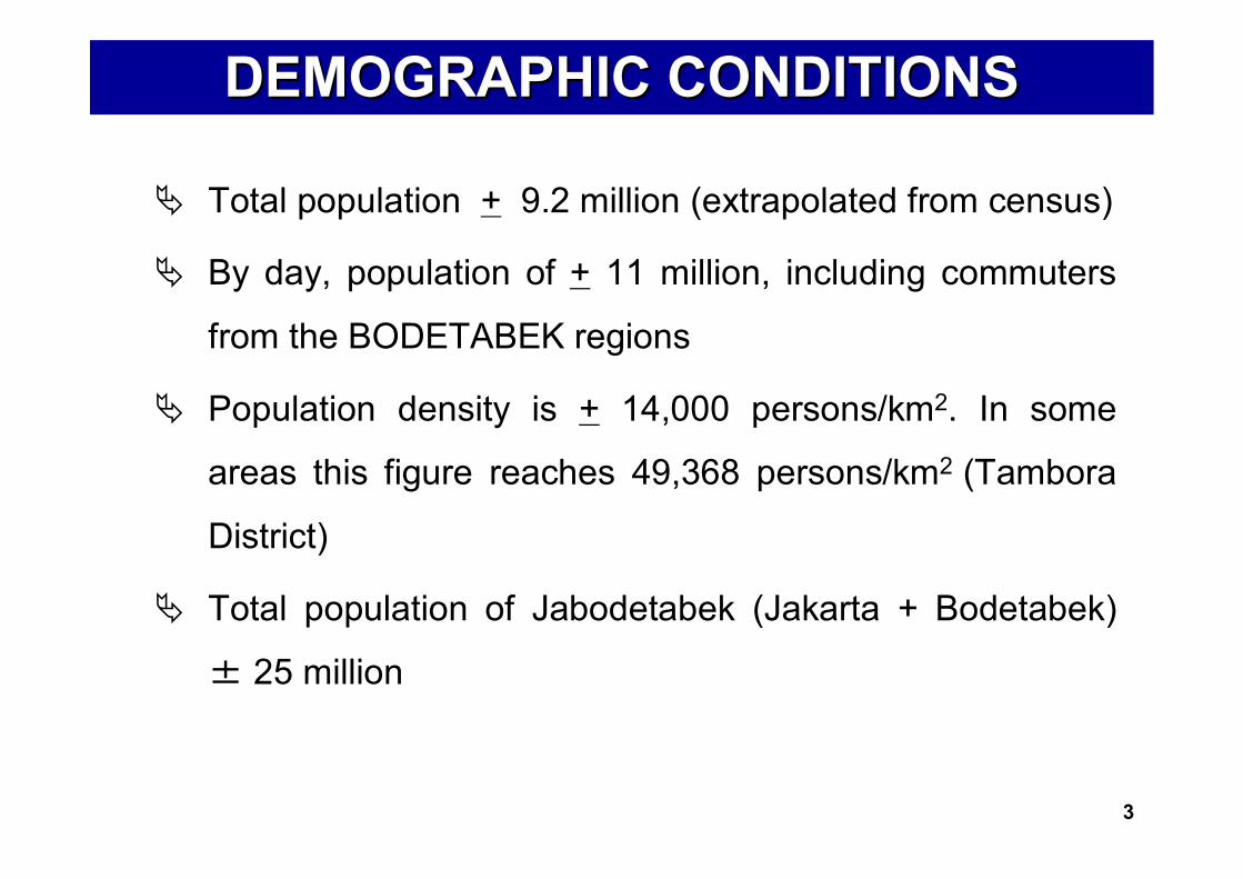
Total population + 9.2 million (extrapolated from census)
By day, population of + 11 million, including commuters
from the BODETABEK regions
Population density is + 14,000 persons/km2. In some
areas this figure reaches 49,368 persons/km2 (Tambora
District)
Total population of Jabodetabek (Jakarta + Bodetabek)
± 25 million
3
STRATEGIC ROLE OF JAKARTASTRATEGIC ROLE OF JAKARTA
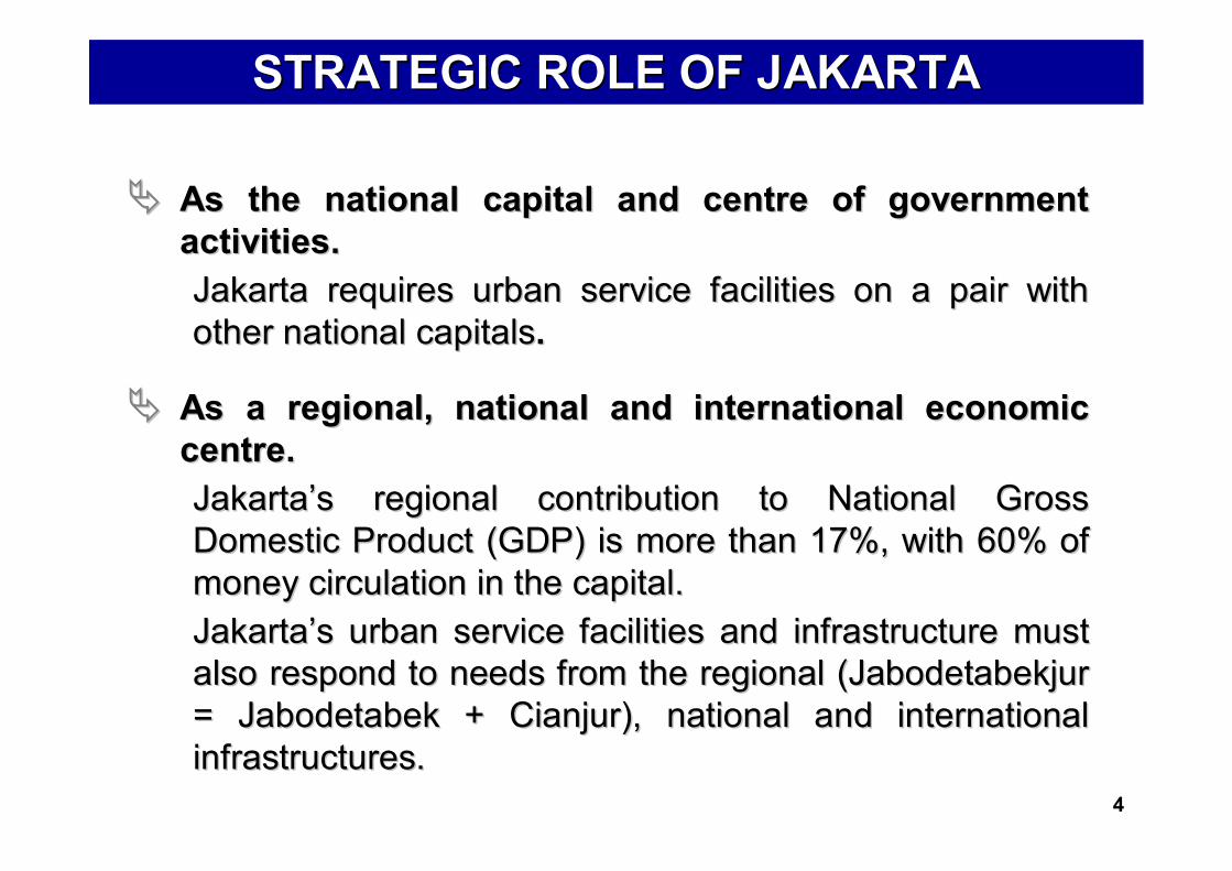
As the national capital and centre of government As the national capital and centre of government activitiesactivities..Jakarta requires urban service facilities on a pair with Jakarta requires urban service facilities on a pair with other national capitalsother national capitals..
As a regional, national and international economic As a regional, national and international economic centre.centre.JakartaJakarta’’s regional contribution to National Gross s regional contribution to National Gross Domestic Product (GDP) is more than 17%, with 60% of Domestic Product (GDP) is more than 17%, with 60% of money circulation in the capital.money circulation in the capital.JakartaJakarta’’s urban service facilities and infrastructure must s urban service facilities and infrastructure must also respond to needs from the regional (Jabodetabekjur also respond to needs from the regional (Jabodetabekjur = Jabodetabek + Cianjur), national and international = Jabodetabek + Cianjur), national and international infrastructures.infrastructures.
4

7,650 km of roads 40.1 km2 of road area (6.26% of Jakarta’s total area- Road Ratio) Annual growth in road length only ± 0.01%
6.7 million motor vehicles in Jakarta 6.6 million private vehicles (98.5%), 91.082 public vehicles (1.5%) Average annual growth over the past 5 years: 11%
20.7 million trips daily across Jakarta
Rp 17.2 billion lost annually due to traffic congestion (loss of time, fuel, and health costs)
ROAD NETWORKS
MOTOR VEHICLES
TRANSPORT MODE BREAKDOWN
TRAVEL REQUIREMENTS
COSTS OF CONGESTION
TRANSPORTATION IN JAKARTATRANSPORTATION IN JAKARTA
98.5% of private vehicles servicing 44% of trips Only 1.5% of vehicles servicing 56% of trips
(including 3% serviced by Jabodetabek trains)
98.5% of private vehicles servicing 44% of trips Only 1.5% of vehicles servicing 56% of trips
(including 3% serviced by Jabodetabek trains)
5
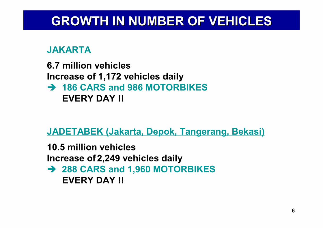
GROWTH IN NUMBER OF VEHICLES GROWTH IN NUMBER OF VEHICLES
JAKARTA 6.7 million vehiclesIncrease of 1,172 vehicles daily 186 CARS and 986 MOTORBIKES
EVERY DAY !!
JADETABEK (Jakarta, Depok, Tangerang, Bekasi)10.5 million vehiclesIncrease of 2,249 vehicles daily 288 CARS and 1,960 MOTORBIKES
EVERY DAY !!
6
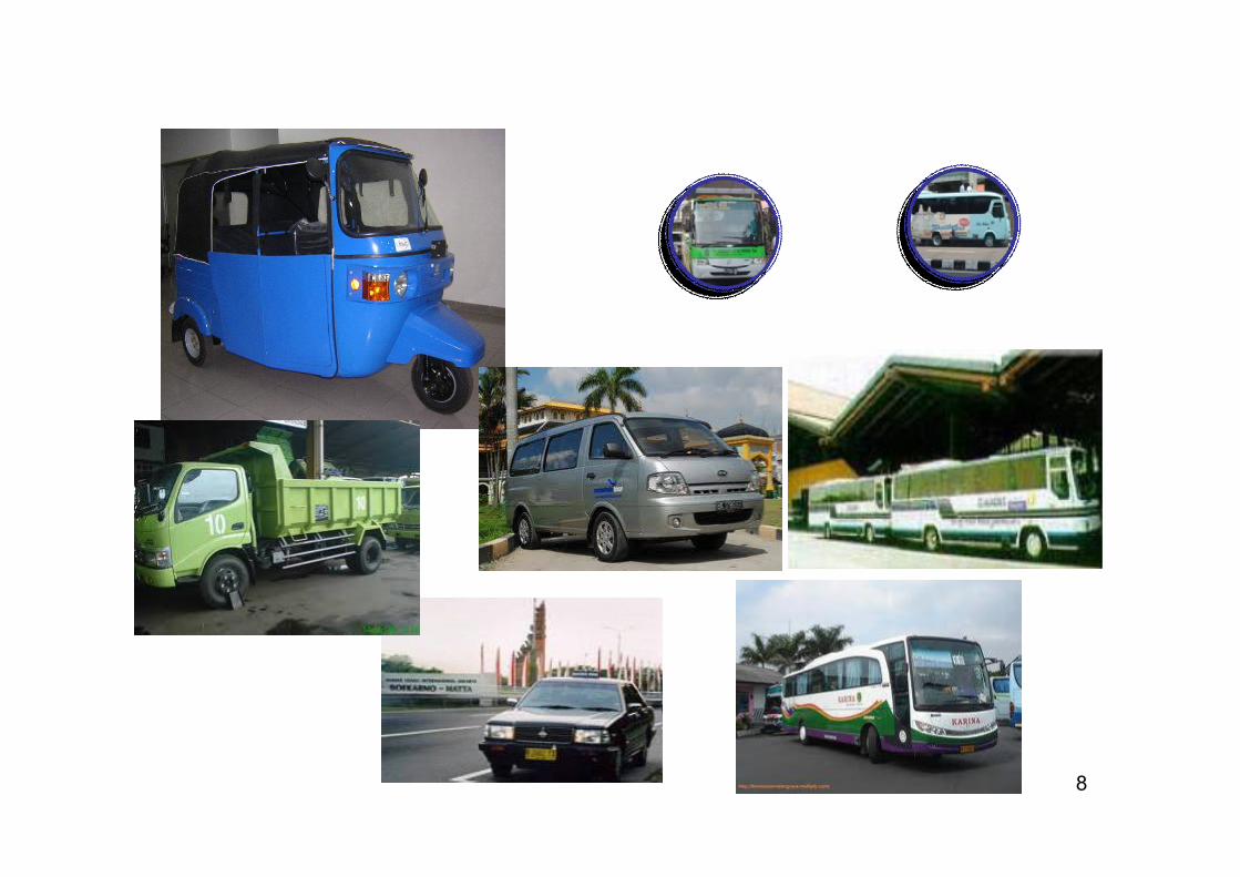
NUMBER OF PUBLIC TRANSPORTNUMBER OF PUBLIC TRANSPORT
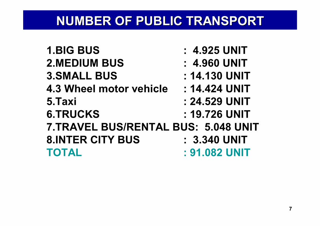
1.BIG BUS : 4.925 UNIT2.MEDIUM BUS : 4.960 UNIT3.SMALL BUS : 14.130 UNIT4.3 Wheel motor vehicle : 14.424 UNIT5.Taxi : 24.529 UNIT6.TRUCKS : 19.726 UNIT7.TRAVEL BUS/RENTAL BUS: 5.048 UNIT8.INTER CITY BUS : 3.340 UNITTOTAL : 91.082 UNIT
7
8
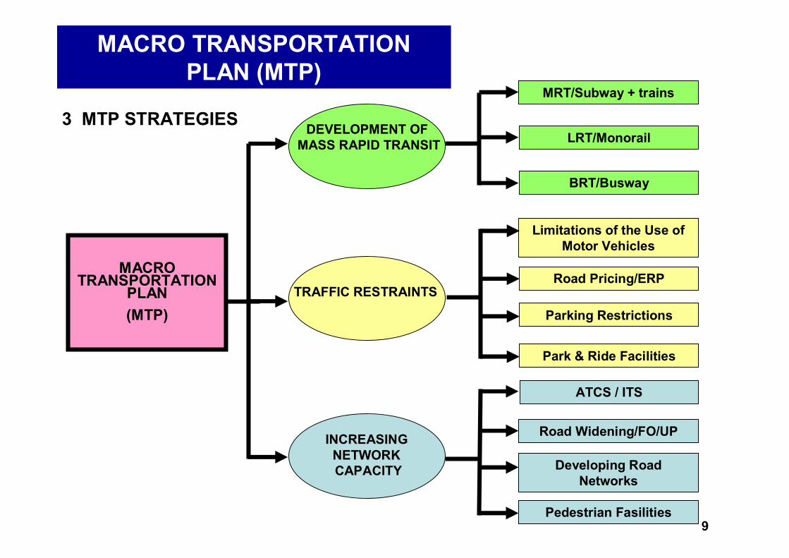
DEVELOPMENT OF MASS RAPID TRANSIT
TRAFFIC RESTRAINTS
INCREASING NETWORK CAPACITY
MRT/Subway + trains
LRT/Monorail
BRT/Busway
Road Pricing/ERP
Parking Restrictions
Park & Ride Facilities
Road Widening/FO/UP
Pedestrian Fasilities
Developing Road Networks
MACRO TRANSPORTATION
PLAN(MTP)
MACRO TRANSPORTATION PLAN (MTP)
Limitations of the Use of Motor Vehicles
ATCS / ITS
3 MTP STRATEGIES
9

Strategy I : Developing Mass Public Transport
1. Bus Rapid Transit (Busway)2. Mass Rapid Transit (Subway +
trains)3. Light Rail Transit (Monorail)
10
BUS RAPID TRANSIT (BUSWAY)
11
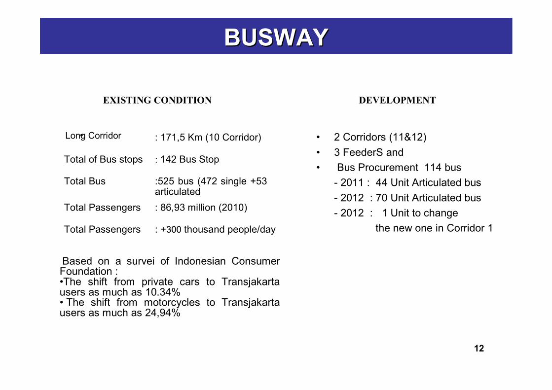
• 2 Corridors (11&12)• 3 FeederS and• Bus Procurement 114 bus
- 2011 : 44 Unit Articulated bus- 2012 : 70 Unit Articulated bus- 2012 : 1 Unit to change
the new one in Corridor 1
12
BUSWAYBUSWAY
EXISTING CONDITION
•Long Corridor : 171,5 Km (10 Corridor)
Total of Bus stops : 142 Bus Stop
Total Bus :525 bus (472 single +53 articulated
Total Passengers : 86,93 million (2010)
Based on a survei of Indonesian Consumer Foundation :•The shift from private cars to Transjakarta users as much as 10.34%• The shift from motorcycles to Transjakarta users as much as 24,94%
Total Passengers : +300 thousand people/day
DEVELOPMENT
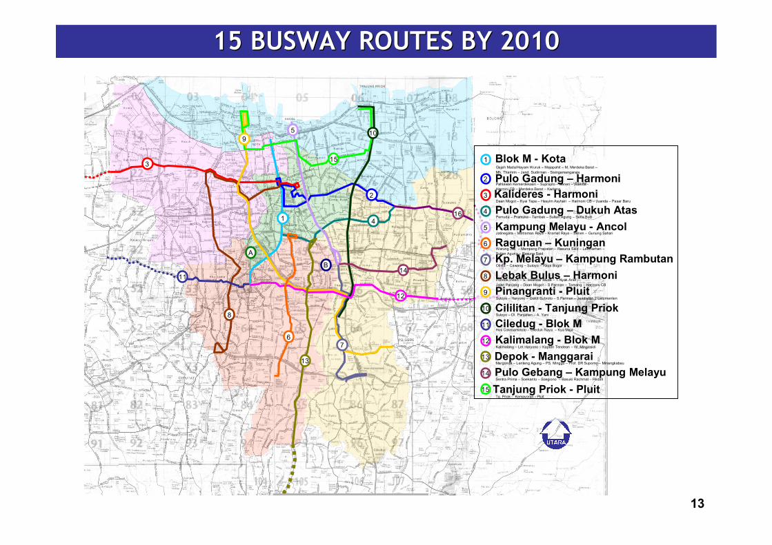
15 BUSWAY ROUTES BY 201015 BUSWAY ROUTES BY 2010
13
7
95 10
41
2
3
8
12
13
14
15
16
A
B
6
11
1 Blok M - KotaGajah Mada/Hayam Wuruk – Majapahit – M. Merdeka Barat –Mh. Thamrin – Jend. Sudirman - Sisingamangaraja
2 Pulo Gadung – HarmoniPahlawan Kemerdekaan – Suprapto – Senen – Juanda -Harmini CB – Merdeka Barat – Kwitang
3 Kalideres - HarmoniDaan Mogot – Kyai Tapa – Hasyim Asyhari – Harmoni CB – Juanda – Pasar Baru
4 Pulo Gadung – Dukuh AtasPemuda – Pramuka - Tambak – Sultan Agung – Setia Budi
5 Kampung Melayu - AncolJatinegara – Matraman Raya – Kramat Raya – Senen – Gunung Sahari
6 Ragunan – KuninganWarung Jati – Mampang Prapatan – Rasuna Said – Latuharhari –Sultan Agung – Rasuna Said
7 Kp. Melayu – Kampung RambutanOtista – Cawang – Sutoyo – Raya Bogor
8 Lebak Bulus – HarmoniPondok Indah – S. Iskandar Muda – T.Nyak Arief –Jalan Panjang – Daan Mogot – S.Parman – Tomang – Harmoni CB
9 Pinangranti - PluitSutoyo – Haryono – Gatot Subroto – S.Parman – Jembatan 2 Latumenten
10 Cililitan - Tanjung PriokSutoyo – DI. Panjaitan – A. Yani
11 Ciledug - Blok MHos Cokroaminoto – Cileduk Raya – Kya Maja
12 Kalimalang - Blok MKalimalang – Let Haryono – Kapten Tendean – W. Minginsidi
13 Depok - ManggaraiMargonda – Lenteng Agung – PS. Minggu – Prof. DR Supomo – Minangkabau
14 Pulo Gebang – Kampung MelayuSentra Prima – Soekanto – Soegiono – Basuki Rachmat – Pedati
15 Tanjung Priok - PluitTg. Priok - Kemayoran - Pluit

FACTS
The number of Busway passengers continues to rise. In 2010 the figure was 100 million (source: BLU-TJ)
In 2006 the Jakarta Provincial Government received an Air Quality Management Champion Award from the Clean Air Initiative for Asian Citiesfor its success in improving the environment through its gas fuel program. According to ITDP (Institute for Transportation and Development Policy) research, annual NOx emissions were reduced by 155 tonnes, annual particle emissions by 23 tonnes, and annual CO2 emissions by 20,000 tonnes.
Has been referred to in several international seminars as an environmentally-friendly form of sustainable public transport
The UN has provided assistance through UNEP (United Nations Environment Program) and technical assistance via ITDP to develop the Transjakarta Busway system from 2006-2011.
PROBLEMS
Insufficient network of gas stations Development of a Feeder Bus System will take time due to the need to
restructure existing routes
BUSWAYBUSWAY
14
FOLLOW-UP STEPS :
• Evaluation and consolidation of planning future busway routes
• Development with better coordination and public education.
• Multi-year development.• Development of a feeder system in order
to optimise Busway services.
BUSWAY
15
SUPPORTING FACILITIES REQUIRED FOR DEVELOPMENT OF THE BUSWAY SYSTEM:
Development of gas fuel provision (including pipelines, filling stations, price policies) for the Busway system
Development of ticketing systems
Development of feeder buses
BUSWAY
16
MASS RAPID TRANSIT (SUBWAY + TRAINS)
17
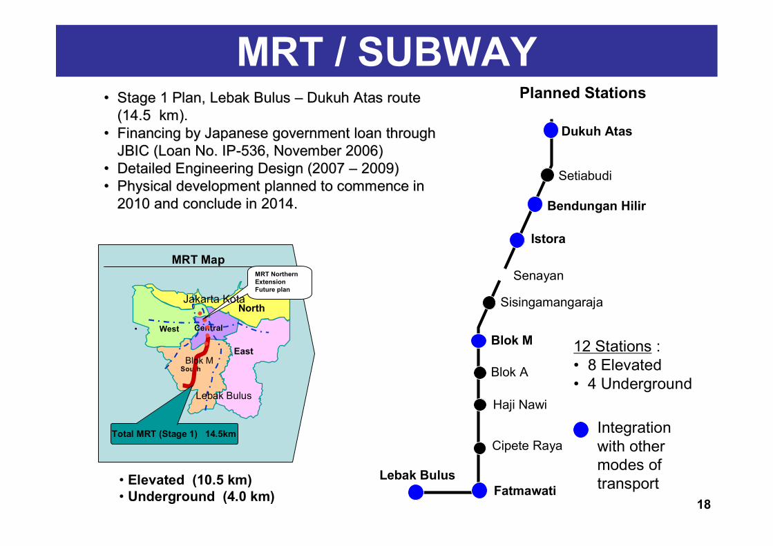
Lebak BulusFatmawati
Cipete Raya
Haji Nawi
Blok A
Blok M
Sisingamangaraja
Senayan
Istora
Bendungan Hilir
Dukuh Atas
Setiabudi
Planned Stations
MRT Map
North
• West Central
East
South
Lebak Bulus
Blok M
Total MRT (Stage 1) 14.5km
MRT Northern ExtensionFuture plan
• Elevated (10.5 km)• Underground (4.0 km)
12 Stations : • 8 Elevated • 4 Underground
Integration with other modes of transport
MRT / SUBWAY•• Stage 1 Plan, Lebak Bulus Stage 1 Plan, Lebak Bulus –– Dukuh Atas route Dukuh Atas route
(14.5 km).(14.5 km).•• Financing by Japanese government loan through Financing by Japanese government loan through
JBIC (Loan No. IPJBIC (Loan No. IP--536, November 2006)536, November 2006)•• Detailed Engineering Design (2007 Detailed Engineering Design (2007 –– 2009)2009)•• Physical development planned to commence in Physical development planned to commence in
2010 and conclude in 2014.2010 and conclude in 2014.
Jakarta Kota
18
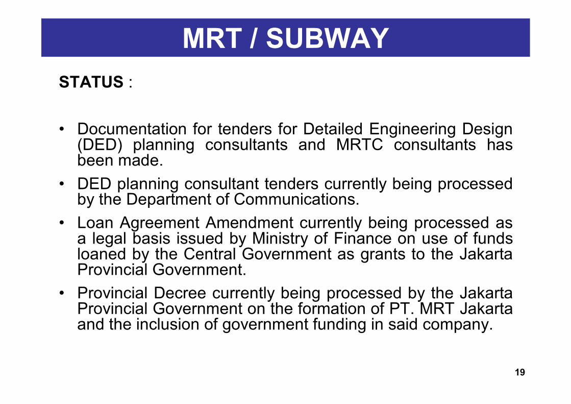
MRT / SUBWAYSTATUS :
• Documentation for tenders for Detailed Engineering Design (DED) planning consultants and MRTC consultants has been made.
• DED planning consultant tenders currently being processed by the Department of Communications.
• Loan Agreement Amendment currently being processed as a legal basis issued by Ministry of Finance on use of funds loaned by the Central Government as grants to the Jakarta Provincial Government.
• Provincial Decree currently being processed by the Jakarta Provincial Government on the formation of PT. MRT Jakarta and the inclusion of government funding in said company.
19
MRT/ SUBWAYFOLLOW-UP STEPS :• Appointment of consultants as DED planners (Dept.
Communications)• Signing Amendment to Stage I Loan Agreement (Dept. Finance
and National Planning Board / Bappenas).• Issuing instruction from Dept. Finance and documents regarding
on-granting to Jakarta Provincial Government (Dept. Finance & National Planning Body)
• Tender for MRTC consultants (after completion of on-granting to Jakarta Regional Government) (Regional Planning Board & MRTC).
• Structuring of Stage II Loan (National Planning Board).• Planning and preparation for construction of MRT (land acquisition
etc) including parallel development of MRTC (as in line with attached Roadmap).
20
MRT / SUBWAY
OTHER MATTERS :
• Studies with JICA assistance to develop the Dukuh Atas area into an integrated intermodal transport hub (MRT, monorail, Jabotabek trains, Busway etc).
21
JABODETABEK RAILWAYJabodetabek train program: Staged development and improvement of Jabotabek
Railway Development of Airport Railway by PT. Railink Operation of Loop Line & Ciliwung Blue Line by PT.
KAI (Indonesian Railways), November 2007
Transit Oriented Development concept (developing areas around railway stations).
Solving railway crossing problems Developing feeder transport and an integrated ticketing
system.
Support from Jakarta Provincial Government for development of Jabodetabek Railway :
22
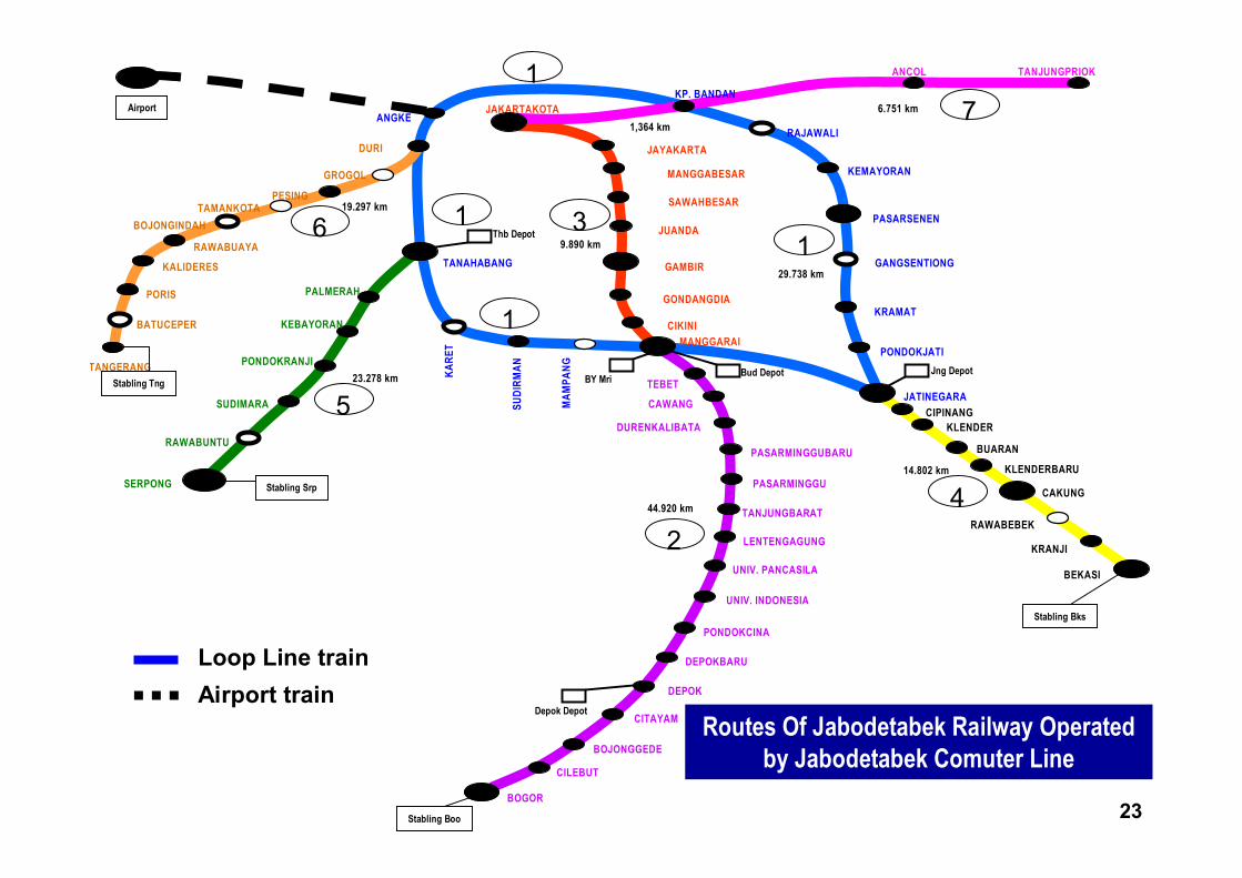
Routes Of Jabodetabek Railway Operated by Jabodetabek Comuter Line
JAKARTAKOTA
JAYAKARTA
MANGGABESAR
SAWAHBESAR
JUANDA
GAMBIR
GONDANGDIA
CIKINIMANGGARAI
KARE
T
SUDI
RMAN
MAM
PANG
TANAHABANG
BATUCEPER
KALIDERES
TANGERANG
PORIS
BOJONGINDAH
RAWABUAYA
PESINGTAMANKOTA
DURI
GROGOL
ANGKE
RAWABUNTU
SUDIMARA
SERPONG
PONDOKRANJI
PALMERAH
KEBAYORAN
KP. BANDAN
RAJAWALI
TANJUNGPRIOKANCOL
KEMAYORAN
PASARSENEN
GANGSENTIONG
KRAMAT
PONDOKJATI
JATINEGARA
KLENDER
BUARAN
KLENDERBARU
CAKUNG
RAWABEBEK
KRANJI
BEKASI
CAWANG
DURENKALIBATA
PASARMINGGUBARU
PASARMINGGU
TANJUNGBARAT
LENTENGAGUNG
UNIV. PANCASILA
UNIV. INDONESIA
PONDOKCINA
DEPOKBARU
DEPOK
CITAYAM
BOJONGGEDE
CILEBUT
BOGOR
TEBET
11
1
1
2
3
4
5
6
7
CIPINANG
1,364 km6.751 km
29.738 km
9.890 km
19.297 km
23.278 km
44.920 km
14.802 km
Bud DepotBY Mri
Depok Depot
Thb Depot
Jng DepotStabling Tng
Stabling Srp
Stabling Boo
Stabling Bks
Airport
Loop Line trainAirport train
23
• To separate long-distance and commuter train services
• To increase the capacity of the Jatinegara – Cikarang rail segment
• To extend commuter trains to Cikarang Station • To move the long-distance terminal station to
Manggarai
OBJECTIVES BEHIND CONSTRUCTION OFMANGGARAI – CIKARANG DOUBLE TRACK LINE :
JABODETABEK RAILWAY
24
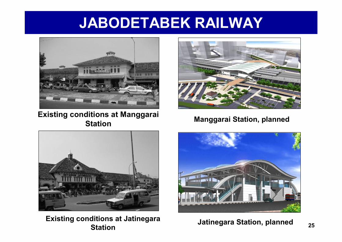
Existing conditions at Manggarai Station Manggarai Station, planned
Existing conditions at Jatinegara Station
Jatinegara Station, planned
JABODETABEK RAILWAY
25
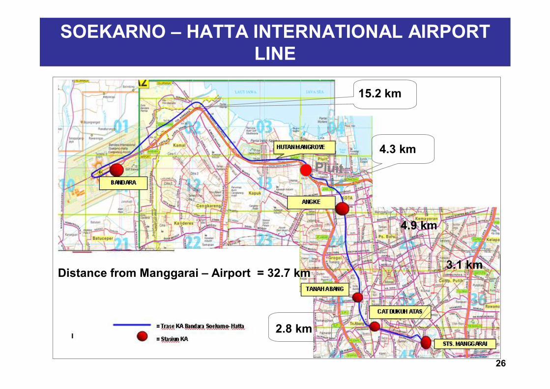
SOEKARNO – HATTA INTERNATIONAL AIRPORT LINE
4.3 km
15.2 km
Pluit
4.9 km
2.8 km
3.1 kmDistance from Manggarai – Airport = 32.7 km
26
SOEKARNO – HATTA INTERNATIONAL AIRPORT LINE
CURRENTLY BEING COORDINATED :
Land requirements for construction of Airport train (Manggarai – Soekarno Hatta International Airport)
Synchronisation of plans for Dukuh Atas Station as a City Air Terminal (CAT) for trains to the airport, taking into account various factors (land use, moving between transport modes, traffic management, etc)
27
MONORAIL
28
MONORAIL
The Monorail was originally a purely private sector venture.
Presently :– As required by PT Jakarta Monorail, the Government has
provided support in the form of Presidential Order 103/2006 and Ministry of Finance Order 30/PMK.02/2007.
– Until now, PT. Jakarta Monorail has not yet realised financial closing.
– Banks have queried three matters: equity, government guarantees and monorail capacity and feasibility regarding totalpassengers.
The Monorail project needs to be redefined, including its form of funding (reverification, including cashflow projection, estimated construction costs, income flow and passengers.)
29
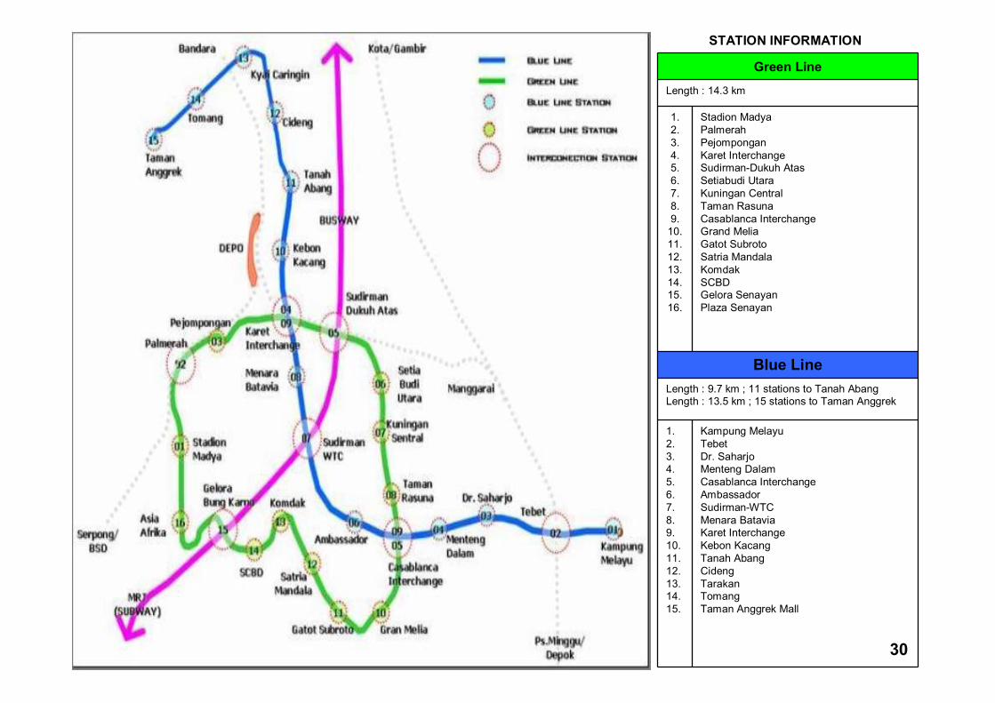
Rute Monorail
Green Line
Length : 14.3 km
1.2.3.4.5.6.7.8.9.
10.11.12.13.14.15.16.
Stadion MadyaPalmerahPejomponganKaret InterchangeSudirman-Dukuh AtasSetiabudi UtaraKuningan CentralTaman RasunaCasablanca InterchangeGrand MeliaGatot SubrotoSatria MandalaKomdakSCBDGelora SenayanPlaza Senayan
Blue LineLength : 9.7 km ; 11 stations to Tanah AbangLength : 13.5 km ; 15 stations to Taman Anggrek
1.2.3.4.5.6.7.8.9.10.11.12.13.14.15.
Kampung MelayuTebet Dr. Saharjo Menteng Dalam Casablanca InterchangeAmbassador Sudirman-WTCMenara BataviaKaret InterchangeKebon Kacang Tanah Abang CidengTarakanTomangTaman Anggrek Mall
STATION INFORMATION
30
Strategy II : Traffic Restraints
1. Reducing Use of Motor Vehicles (‘3 in 1’ system on main thoroughfares, other restraints needed)
2. Alternative Road Pricing/ERP (currently under study)
3. Parking Restrictions (tariff mechanism)4. Park & Ride facilities, to support the use of
public transport (Ragunan dan Kalideres Terminals)
31
Strategy III : Increasing Network Capacity
1. Integration of Area Traffic Control System (ATCS) and Traffic Light Control to increase Road Network Capacity (improvements to current system)
2. Maintenance/Improvement of Roads and Construction of Flyovers/Tunnels
3. Development of Road Networks including Toll Road Network
4. Improving Pedestrian Facilities (Pedestrianisation)
32
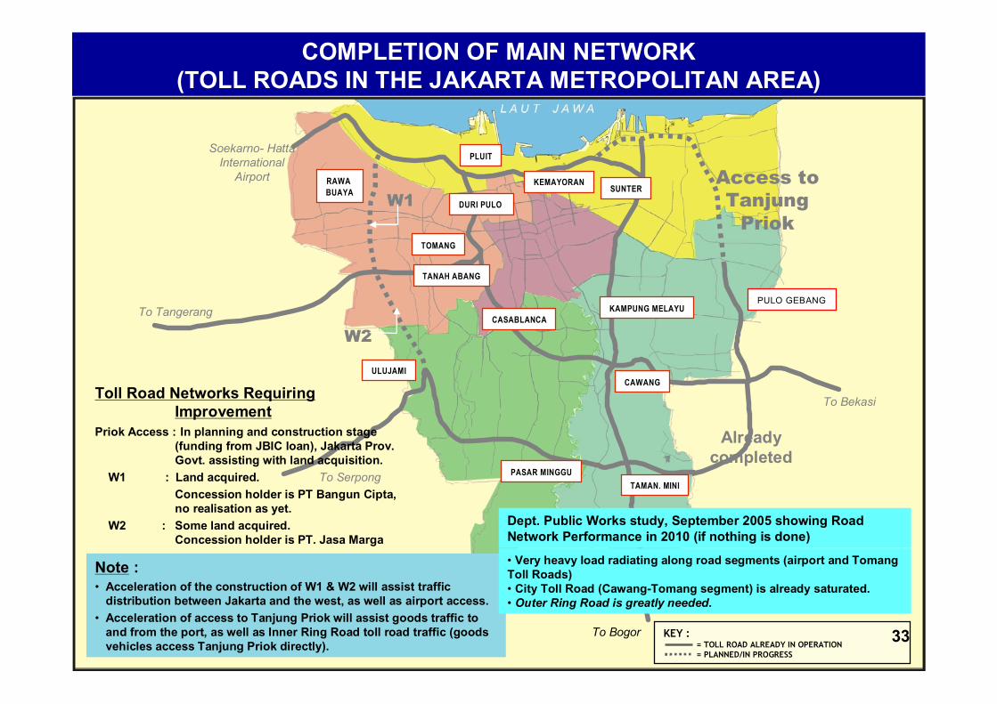
KEY := TOLL ROAD ALREADY IN OPERATION= PLANNED/IN PROGRESS
COMPLETION OF MAIN NETWORK (TOLL ROADS IN THE JAKARTA METROPOLITAN AREA)
ULUJAMI
TOMANG
PULO GEBANG
KEMAYORAN
PASAR MINGGU
RAWA BUAYA
KAMPUNG MELAYU
TAMAN. MINI
PLUIT
SUNTER
CAWANG
DURI PULO
TANAH ABANG
CASABLANCA
Note :• Acceleration of the construction of W1 & W2 will assist traffic
distribution between Jakarta and the west, as well as airport access.• Acceleration of access to Tanjung Priok will assist goods traffic to
and from the port, as well as Inner Ring Road toll road traffic (goods vehicles access Tanjung Priok directly).
Toll Road Networks Requiring Improvement
Priok Access : In planning and construction stage (funding from JBIC loan), Jakarta Prov. Govt. assisting with land acquisition.
W1 : Land acquired.Concession holder is PT Bangun Cipta, no realisation as yet.
W2 : Some land acquired.Concession holder is PT. Jasa Marga
W1
W2
Access to Tanjung
Priok
Soekarno- Hatta International
Airport
To Tangerang
To Bogor
To Bekasi
To Serpong
Already completed
• Very heavy load radiating along road segments (airport and Tomang Toll Roads)• City Toll Road (Cawang-Tomang segment) is already saturated.• Outer Ring Road is greatly needed.
Dept. Public Works study, September 2005 showing Road Network Performance in 2010 (if nothing is done)
33
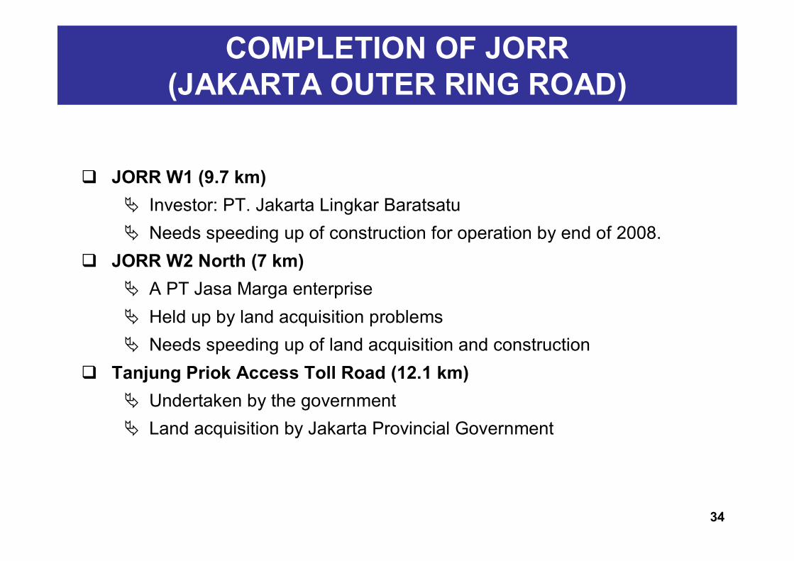
JORR W1 (9.7 km) Investor: PT. Jakarta Lingkar Baratsatu Needs speeding up of construction for operation by end of 2008.
JORR W2 North (7 km) A PT Jasa Marga enterprise Held up by land acquisition problems Needs speeding up of land acquisition and construction
Tanjung Priok Access Toll Road (12.1 km) Undertaken by the government Land acquisition by Jakarta Provincial Government
COMPLETION OF JORR (JAKARTA OUTER RING ROAD)
34
ULUJAMI
TOMANG
PULO GEBANG
KEMAYORAN
TANGERANG
SERPONG
PASAR MINGGU
RAWA BUAYA
KAMPUNG MELAYU
AIRPORT
TO MERAK
TO BOGOR
TO BEKASI/CIKAMPEK
TAMAN. MINI
PLUIT
SUNTER
CAWANG
TO BEKASI
TANJUNG PRIOK ACCESS
1
2
3
4
5
6
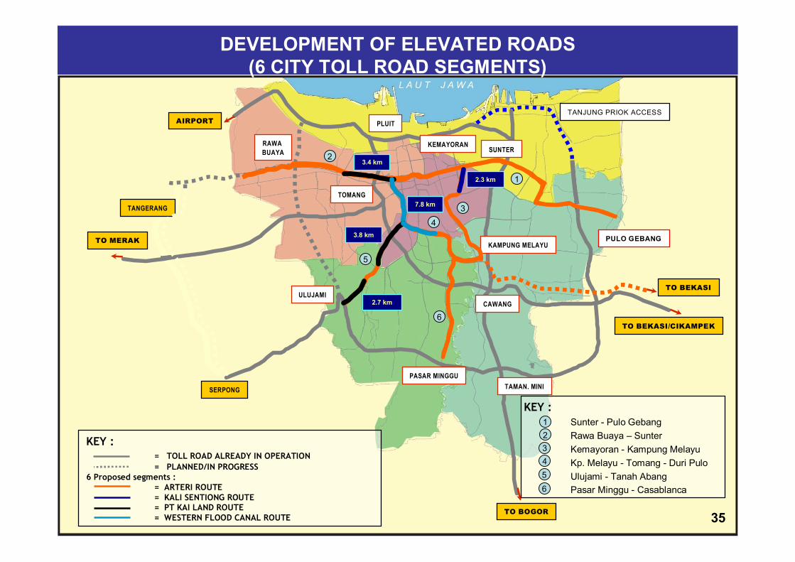
KEY :Sunter - Pulo GebangRawa Buaya – SunterKemayoran - Kampung MelayuKp. Melayu - Tomang - Duri PuloUlujami - Tanah AbangPasar Minggu - Casablanca
123456
KEY := TOLL ROAD ALREADY IN OPERATION= PLANNED/IN PROGRESS
6 Proposed segments := ARTERI ROUTE= KALI SENTIONG ROUTE= PT KAI LAND ROUTE= WESTERN FLOOD CANAL ROUTE
3.4 km
3.8 km
2.7 km
7.8 km
2.3 km
DEVELOPMENT OF ELEVATED ROADS(6 CITY TOLL ROAD SEGMENTS)
35
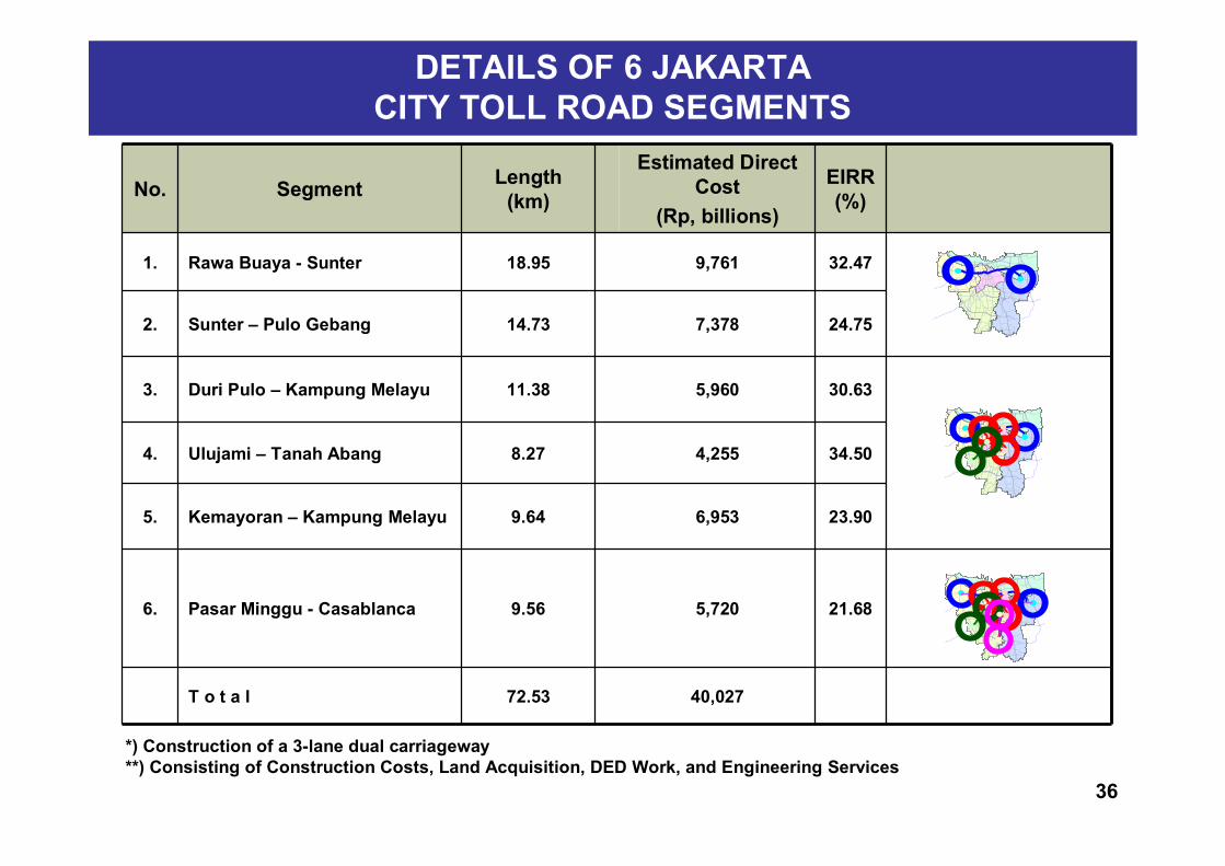
No. Segment Length (km)
Estimated Direct Cost
(Rp, billions)
EIRR (%)
1. Rawa Buaya - Sunter 18.95 9,761 32.47
2. Sunter – Pulo Gebang 14.73 7,378 24.75
3. Duri Pulo – Kampung Melayu 11.38 5,960 30.63
4. Ulujami – Tanah Abang 8.27 4,255 34.50
5. Kemayoran – Kampung Melayu 9.64 6,953 23.90
6. Pasar Minggu - Casablanca 9.56 5,720 21.68
T o t a l 72.53 40,027
DETAILS OF 6 JAKARTA CITY TOLL ROAD SEGMENTS
*) Construction of a 3-lane dual carriageway**) Consisting of Construction Costs, Land Acquisition, DED Work, and Engineering Services
36
Below are Jakarta Provincial Government suggestions to the central government (Minister of Public Works) re 6 City Toll Road segments in Jakarta with the following considerations:
- As part of efforts at increasing new road networks to improve the road ratio
- Improving Road Network Structure Hierarchy in Jakarta (Arterial Road Networks which currently do not meet standards)
PLANNED DEVELOPMENT OF PLANNED DEVELOPMENT OF 6 JAKARTA CITY TOLL ROAD SEGMENTS6 JAKARTA CITY TOLL ROAD SEGMENTS
37
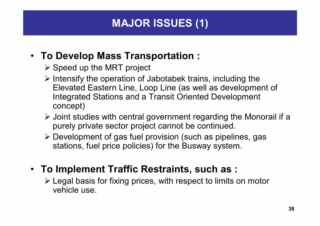
MAJOR ISSUES (1)
• To Develop Mass Transportation : Speed up the MRT project Intensify the operation of Jabotabek trains, including the
Elevated Eastern Line, Loop Line (as well as development of Integrated Stations and a Transit Oriented Development concept)
Joint studies with central government regarding the Monorail if a purely private sector project cannot be continued.
Development of gas fuel provision (such as pipelines, gas stations, fuel price policies) for the Busway system.
• To Implement Traffic Restraints, such as : Legal basis for fixing prices, with respect to limits on motor
vehicle use.
38
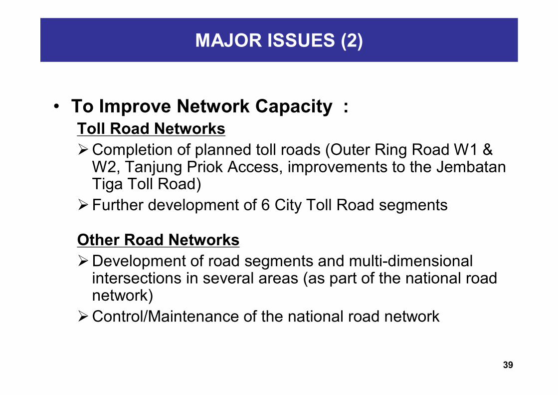
MAJOR ISSUES (2)
• To Improve Network Capacity : Toll Road NetworksCompletion of planned toll roads (Outer Ring Road W1 &
W2, Tanjung Priok Access, improvements to the Jembatan Tiga Toll Road)
Further development of 6 City Toll Road segments
Other Road NetworksDevelopment of road segments and multi-dimensional
intersections in several areas (as part of the national road network)
Control/Maintenance of the national road network
39

.
SEKIAN & TERIMA KASIH

THANK YOU
41