Restructuration of topographic Finnish data, LC/LU · Restructuration of topographic Finnish data,...
10
Restructuration of topographic Finnish data, LC/LU Senior specialist Ulla Pyysalo 15.11.2017 EursoSDR, Land use/land cover products: challenges and opportunities
Transcript of Restructuration of topographic Finnish data, LC/LU · Restructuration of topographic Finnish data,...
Restructuration of topographic
Finnish data, LC/LU
Senior specialist Ulla Pyysalo
15.11.2017
EursoSDR, Land use/land cover products:
challenges and opportunities
Finnish topographic database today
• The most detailed and up-to-date nation wide general topographic information of
Finland.
• First version of the database was generated by digitizing paper maps in 1990.
• Maintenance processes today are
1) Periodical updating
• Based on aerial photography and stereo collision
• Intervals 5-10 years
2) Continuous updating
• Transportation networks and buildings only.
• Mainly based on official information and clues from various sources from other
authorities.
LU/LC in topographic database
• Land use and land cover feature classes are part of the content and maintained
by periodical updating process.
• Majority of these classes represent land cover.
• Land use classes are surveyed for two reasons
1) Generalization, example park or cemetery.
2) Land use prohibits land cover to be seen, example dump.
• LU/LC classes are utilized among other data sources by Finnish Environment
Institute in order to provide Corine land cover data of Finland.
• Together, land use and cover polygons cover less than 50 % of the area.
3
4
Future user requirements
• A User study in 2015
• GIS expert interviews
• Webropol study for customers
• Serie of workshops 2016-2017
• Buildings and other constructions, 2 events
• Traffic network, 2 events
• Terrain (including LC/LU), 2 events
• Security sector
• Serie of meetings with Finnish Environment Institute and Finnish Forest centre.
5
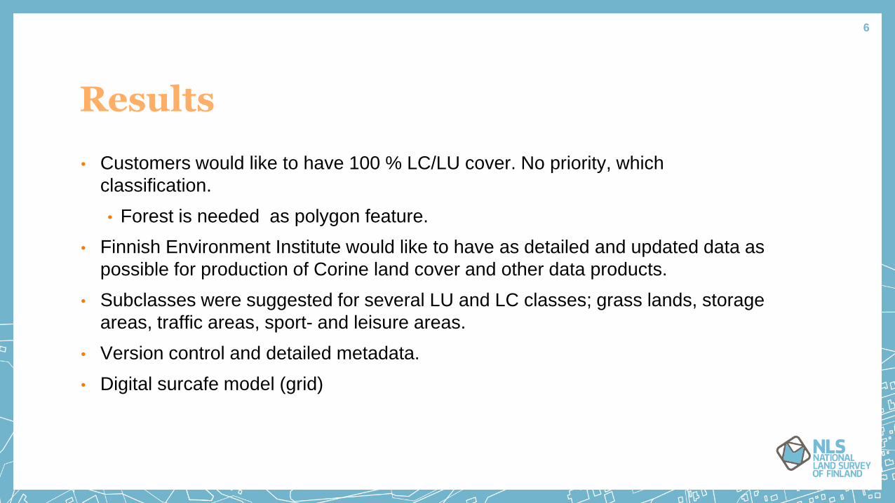
Results
• Customers would like to have 100 % LC/LU cover. No priority, which
classification.
• Forest is needed as polygon feature.
• Finnish Environment Institute would like to have as detailed and updated data as
possible for production of Corine land cover and other data products.
• Subclasses were suggested for several LU and LC classes; grass lands, storage
areas, traffic areas, sport- and leisure areas.
• Version control and detailed metadata.
• Digital surcafe model (grid)
6
Build
ing a
rea
Sto
rage a
rea
Road a
nd ra
il
netw
ork
s a
nd
associa
ted la
nd
Airp
ort
Min
era
l extra
ctio
n
site
Open m
ine
Dum
p s
ite
Cem
ete
ry
Gre
en u
rban a
reas
Sport a
nd le
isure
facilitie
s
Agric
ultu
ral a
reas
Meadow
lands
Bare
sand
Rock file
d
Bould
er fie
ld
Palu
difie
d a
rea
Mars
h la
nd
Reeds
Relic
tion
Wate
r bodie
s,
lakes a
nd m
arin
e
Earth
fill
Wate
r bodie
s,
river a
reas
Terra
in 1
Terra
in 2
~
Urb
an a
rea
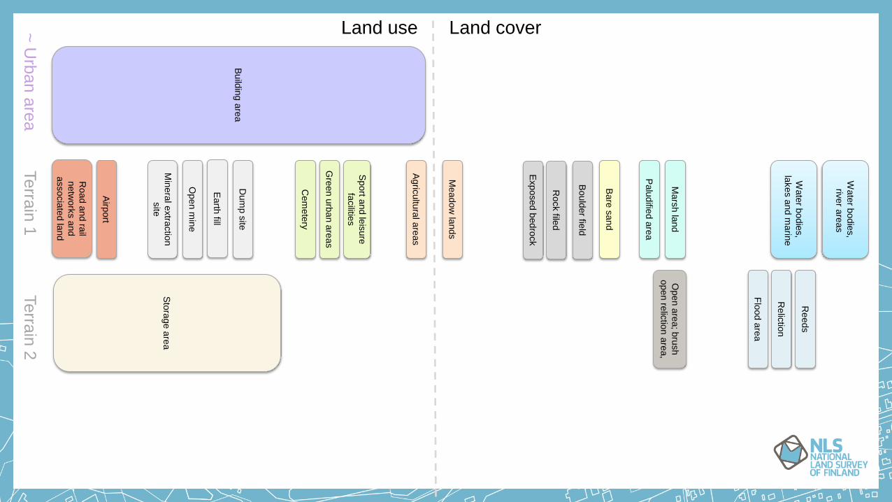
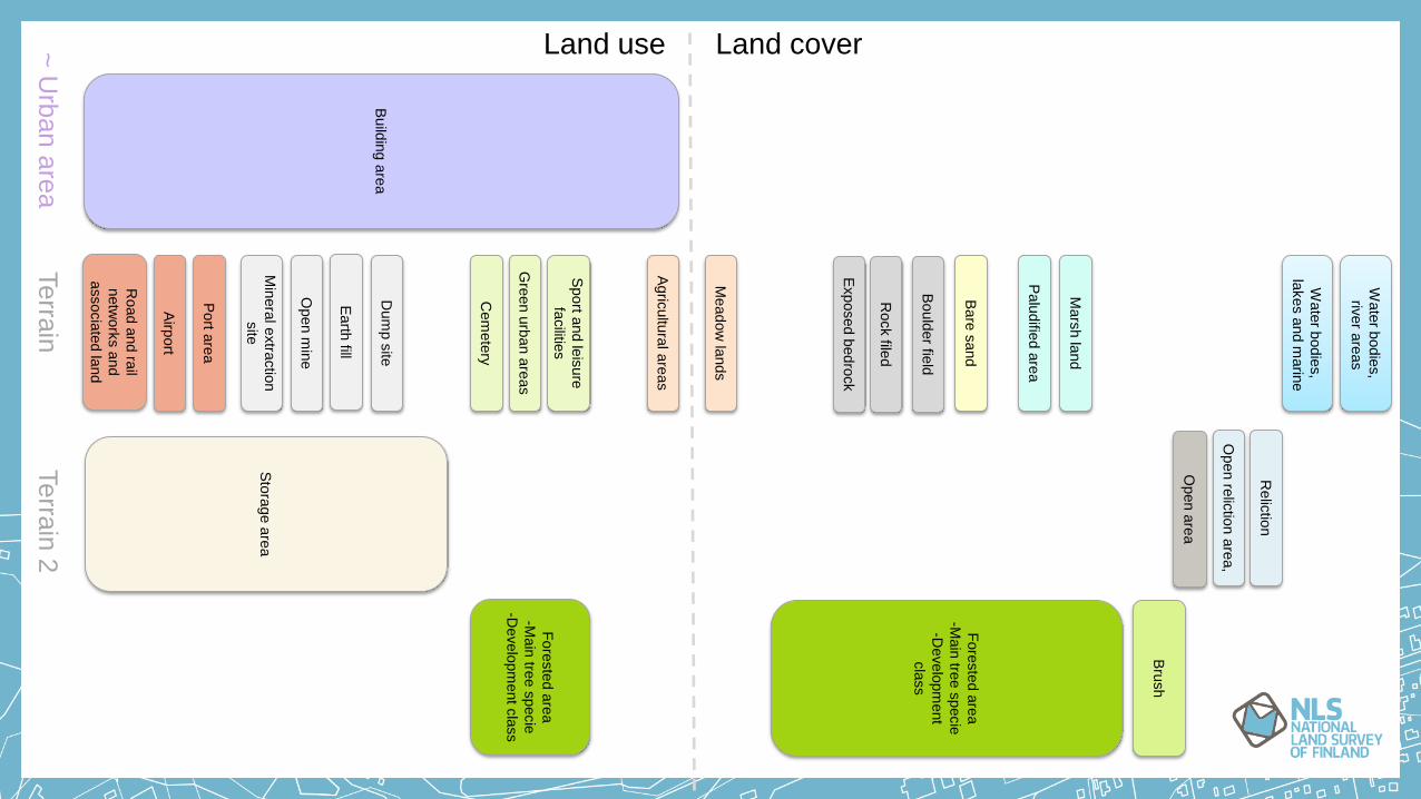
Land cover Land use
Exposed
bedro
ck
Open a
rea; b
rush
open re
lictio
n a
rea,
Flo
od a
rea
Build
ing a
rea
Sto
rage a
rea
Road a
nd ra
il
netw
ork
s a
nd
associa
ted la
nd
Airp
ort
Port a
rea
Min
era
l extra
ctio
n
site
Open m
ine
Dum
p s
ite
Cem
ete
ry
Gre
en u
rban a
reas
Sport a
nd le
isure
facilitie
s
Agric
ultu
ral a
reas
Meadow
lands
Bare
sand
Rock file
d
Bould
er fie
ld
Palu
difie
d a
rea
Mars
h la
nd
Relic
tion
Wate
r bodie
s,
lakes a
nd m
arin
e
Earth
fill
Wate
r bodie
s,
river a
reas
Terra
in
Terra
in 2
~
Urb
an a
rea
Fore
ste
d a
rea
-Main
tree s
pecie
-Develo
pm
ent
cla
ss
Land cover Land use
Exposed
bedro
ck
Open a
rea
Open re
lictio
n a
rea,
Bru
sh
Fore
ste
d a
rea
-Main
tree s
pecie
-Develo
pm
ent c
lass
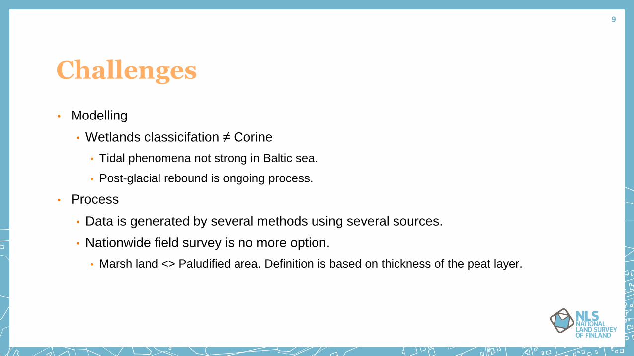
Challenges
• Modelling
• Wetlands classicifation ≠ Corine
• Tidal phenomena not strong in Baltic sea.
• Post-glacial rebound is ongoing process.
• Process
• Data is generated by several methods using several sources.
• Nationwide field survey is no more option.
• Marsh land <> Paludified area. Definition is based on thickness of the peat layer.
9