RESOLUTION NO. PC 16-08 A RESOLUTION OF THE...
7
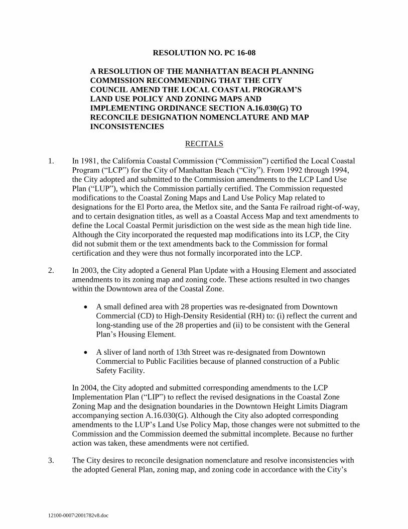
12100-0007\2001782v8.doc RESOLUTION NO. PC 16-08 A RESOLUTION OF THE MANHATTAN BEACH PLANNING COMMISSION RECOMMENDING THAT THE CITY COUNCIL AMEND THE LOCAL COASTAL PROGRAM’S LAND USE POLICY AND ZONING MAPS AND IMPLEMENTING ORDINANCE SECTION A.16.030(G) TO RECONCILE DESIGNATION NOMENCLATURE AND MAP INCONSISTENCIES RECITALS 1. In 1981, the California Coastal Commission (“Commission”) certified the Local Coastal Program (“LCP”) for the City of Manhattan Beach (“City”). From 1992 through 1994, the City adopted and submitted to the Commission amendments to the LCP Land Use Plan (“LUP”), which the Commission partially certified. The Commission requested modifications to the Coastal Zoning Maps and Land Use Policy Map related to designations for the El Porto area, the Metlox site, and the Santa Fe railroad right-of-way, and to certain designation titles, as well as a Coastal Access Map and text amendments to define the Local Coastal Permit jurisdiction on the west side as the mean high tide line. Although the City incorporated the requested map modifications into its LCP, the City did not submit them or the text amendments back to the Commission for formal certification and they were thus not formally incorporated into the LCP. 2. In 2003, the City adopted a General Plan Update with a Housing Element and associated amendments to its zoning map and zoning code. These actions resulted in two changes within the Downtown area of the Coastal Zone. A small defined area with 28 properties was re-designated from Downtown Commercial (CD) to High-Density Residential (RH) to: (i) reflect the current and long-standing use of the 28 properties and (ii) to be consistent with the General Plan’s Housing Element. A sliver of land north of 13th Street was re-designated from Downtown Commercial to Public Facilities because of planned construction of a Public Safety Facility. In 2004, the City adopted and submitted corresponding amendments to the LCP Implementation Plan (“LIP”) to reflect the revised designations in the Coastal Zone Zoning Map and the designation boundaries in the Downtown Height Limits Diagram accompanying section A.16.030(G). Although the City also adopted corresponding amendments to the LUP’s Land Use Policy Map, those changes were not submitted to the Commission and the Commission deemed the submittal incomplete. Because no further action was taken, these amendments were not certified. 3. The City desires to reconcile designation nomenclature and resolve inconsistencies with the adopted General Plan, zoning map, and zoning code in accordance with the City’s
-
Upload
trankhuong -
Category
Documents
-
view
215 -
download
2
Transcript of RESOLUTION NO. PC 16-08 A RESOLUTION OF THE...
12100-0007\2001782v8.doc
RESOLUTION NO. PC 16-08
A RESOLUTION OF THE MANHATTAN BEACH PLANNING
COMMISSION RECOMMENDING THAT THE CITY
COUNCIL AMEND THE LOCAL COASTAL PROGRAM’S
LAND USE POLICY AND ZONING MAPS AND
IMPLEMENTING ORDINANCE SECTION A.16.030(G) TO
RECONCILE DESIGNATION NOMENCLATURE AND MAP
INCONSISTENCIES
RECITALS
1. In 1981, the California Coastal Commission (“Commission”) certified the Local Coastal
Program (“LCP”) for the City of Manhattan Beach (“City”). From 1992 through 1994,
the City adopted and submitted to the Commission amendments to the LCP Land Use
Plan (“LUP”), which the Commission partially certified. The Commission requested
modifications to the Coastal Zoning Maps and Land Use Policy Map related to
designations for the El Porto area, the Metlox site, and the Santa Fe railroad right-of-way,
and to certain designation titles, as well as a Coastal Access Map and text amendments to
define the Local Coastal Permit jurisdiction on the west side as the mean high tide line.
Although the City incorporated the requested map modifications into its LCP, the City
did not submit them or the text amendments back to the Commission for formal
certification and they were thus not formally incorporated into the LCP.
2. In 2003, the City adopted a General Plan Update with a Housing Element and associated
amendments to its zoning map and zoning code. These actions resulted in two changes
within the Downtown area of the Coastal Zone.
A small defined area with 28 properties was re-designated from Downtown
Commercial (CD) to High-Density Residential (RH) to: (i) reflect the current and
long-standing use of the 28 properties and (ii) to be consistent with the General
Plan’s Housing Element.
A sliver of land north of 13th Street was re-designated from Downtown
Commercial to Public Facilities because of planned construction of a Public
Safety Facility.
In 2004, the City adopted and submitted corresponding amendments to the LCP
Implementation Plan (“LIP”) to reflect the revised designations in the Coastal Zone
Zoning Map and the designation boundaries in the Downtown Height Limits Diagram
accompanying section A.16.030(G). Although the City also adopted corresponding
amendments to the LUP’s Land Use Policy Map, those changes were not submitted to the
Commission and the Commission deemed the submittal incomplete. Because no further
action was taken, these amendments were not certified.
3. The City desires to reconcile designation nomenclature and resolve inconsistencies with
the adopted General Plan, zoning map, and zoning code in accordance with the City’s

Resolution No. PC 16-08
-2- 12100-0007\2001782v8.doc
prior submittals and the Commission’s requests in 1994 and 2004. These LCP
amendments correct the prior procedural deficiencies and are consistent with long-
standing and actual land uses. As such, they do not change actual land uses or land use
policies in the Coastal Zone. Instead, they merely reconcile inconsistencies and formalize
prior amendments.
NOW THEREFORE, THE MANHATTAN BEACH PLANNING COMMISSION
HEREBY FINDS AND RESOLVES AS FOLLOWS:
SECTION 1. CEQA. In accordance with the California Environmental Quality Act
(“CEQA”), the City prepared an Initial Study/Mitigated Negative Declaration (“MND”), which
analyzed the Downtown Specific Plan and amendments to the General Plan, zoning map, zoning
code, and Local Coastal Program, including the amendments herein (“Project). By Resolution
No. PC 16-06, the Planning Commission made CEQA findings and recommended that the City
Council adopt the MND and Mitigation Monitoring and Reporting Program for the Project. The
CEQA findings and recommendation in Resolution No. PC 16-06 are incorporated hereto as if
set forth in full. In addition, pursuant to Public Resources Code Section 21080.9, CEQA does not
apply to activities and approvals by the City necessary for the preparation and adoption of an
LCP amendment. The proposed action is an amendment to the City’s LCP, which must be
certified by the California Coastal Commission before it takes effect.
SECTION 2. The proposed LCP amendments are consistent with the General Plan
because they resolve the LCP’s existing inconsistencies with existing conditions and the City’s
land use designations in the Downtown area.
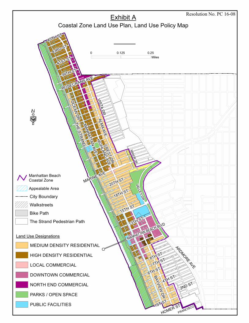
SECTION 3. The Planning Commission recommends that the City Council replace the
Coastal Zone Land Use Plan, Land Use Policy Map with the map attached as Exhibit A.
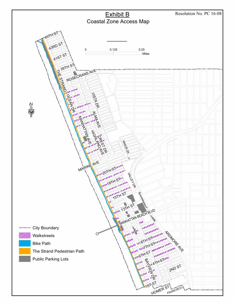
SECTION 4. The Planning Commission recommends that the City Council adopt the
Coastal Zone Access Map attached as Exhibit B.
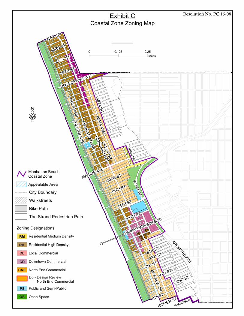
SECTION 5. The Planning Commission recommends that the City Council replace the
Coastal Zone Zoning Map adopted by Ordinance No. 1899, and referenced in LIP Zoning
Ordinance Section A.01.020(B), to be located after page IV-2 of the Coastal Zone Land Use
Plan, with the map attached as Exhibit C.
SECTION 6. The Planning Commission recommends that the City Council replace the
Downtown Commercial District Height Limits Diagram in LIP Zoning Ordinance, Chapter A.16,
Section A.16.030(G) with the diagram attached as Exhibit D.
SECTION 7. The Planning Commission recommends that the City Council amend the
Local Coastal Program Phase II Land Use Plan Amendment, January 1994, Section I, Executive
Summary, Coastal Zone, to revise the third paragraph on page I-2 to read as follows:
“Coastal Zone
The City’s Local Coastal Permit Jurisdiction is within the City of Manhattan Beach coastal zone.
The east Manhattan Beach coastal zone boundary, for the most part, is the dividing line between
the RS and RM zoned properties in the beach area. The north and south boundaries are city limit
Resolution No. PC 16-08
-3- 12100-0007\2001782v8.doc
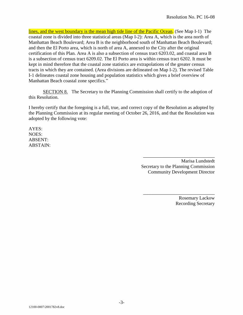
lines, and the west boundary is the mean high tide line of the Pacific Ocean. (See Map I-1) The
coastal zone is divided into three statistical areas (Map I-2): Area A, which is the area north of
Manhattan Beach Boulevard; Area B is the neighborhood south of Manhattan Beach Boulevard;
and then the El Porto area, which is north of area A, annexed to the City after the original
certification of this Plan. Area A is also a subsection of census tract 6203.02, and coastal area B
is a subsection of census tract 6209.02. The El Porto area is within census tract 6202. It must be
kept in mind therefore that the coastal zone statistics are extrapolations of the greater census
tracts in which they are contained. (Area divisions are delineated on Map I-2). The revised Table
I-1 delineates coastal zone housing and population statistics which gives a brief overview of
Manhattan Beach coastal zone specifics.”
SECTION 8. The Secretary to the Planning Commission shall certify to the adoption of
this Resolution.
I hereby certify that the foregoing is a full, true, and correct copy of the Resolution as adopted by
the Planning Commission at its regular meeting of October 26, 2016, and that the Resolution was
adopted by the following vote:
AYES:
NOES:
ABSENT:
ABSTAIN:
______________________________
Marisa Lundstedt
Secretary to the Planning Commission
Community Development Director
______________________________
Rosemary Lackow
Recording Secretary
VALLEY DR
MANOR DR
OCEAN DRTHE STRAND
HIGHLAND AVE
ROSECRANS AVEARDMORE AVE
MARINE AVE
VISTA DRALMA AVE
CREST DR
15TH ST
MANHATTAN BEACH BLVD
4TH ST
7TH ST
MANHATTAN AVE
20TH ST
BAYVIEW DR
18TH ST
41ST ST
45TH ST
39TH ST
43RD ST
FRANCISCOHOMER ST
6TH ST
2ND ST
8TH ST
1ST ST
13TH ST
·
0 0.250.125Miles
Exhibit A Coastal Zone Land Use Plan, Land Use Policy Map
Land Use DesignationsMEDIUM DENSITY RESIDENTIALHIGH DENSITY RESIDENTIALLOCAL COMMERCIALDOWNTOWN COMMERCIALNORTH END COMMERCIALPARKS / OPEN SPACEPUBLIC FACILITIES
City BoundaryWalkstreetsBike PathThe Strand Pedestrian Path
Appealable Area
Manhattan BeachCoastal Zone
Resolution No. PC 16-08
VALLEY DR
MANOR DR
OCEAN DR
THE STRAND
HIGHLAND AVE
ROSECRANS AVEARDMORE AVE
MARINE AVE
VISTA DRALMA AVE
CREST DR
15TH ST
MANHATTAN BEACH BLVD
4TH ST
7TH ST
MANHATTAN AVE
20TH ST
BAYVIEW DR
18TH ST
41ST ST
45TH ST
39TH ST
43RD ST
FRANCISCOHOMER ST
6TH ST
2ND ST
8TH ST
1ST ST
13TH ST
·
0 0.250.125Miles
City BoundaryWalkstreetsBike PathThe Strand Pedestrian PathPublic Parking Lots
Exhibit B Coastal Zone Access Map
Resolution No. PC 16-08
VALLEY DR
MANOR DR
OCEAN DRTHE STRAND
HIGHLAND AVE
ROSECRANS AVEARDMORE AVE
MARINE AVE
VISTA DRALMA AVE
CREST DR
15TH ST
MANHATTAN BEACH BLVD
4TH ST
7TH ST
MANHATTAN AVE
20TH ST
BAYVIEW DR
18TH ST
41ST ST
45TH ST
39TH ST
43RD ST
FRANCISCOHOMER ST
6TH ST
2ND ST
8TH ST
1ST ST
13TH ST
·
0 0.250.125Miles
Land Use DesignationsMEDIUM DENSITY RESIDEHIGH DENSITY RESIDENTILOCAL COMMERCIALDOWNTOWN COMMERCIALNORTH END COMMERCIALPARKS / OPEN SPACEPUBLIC FACILITIES
City BoundaryWalkstreetsBike PathThe Strand Pedestrian Path
Zoning Designations
OS Open SpacePS Public and Semi-Public
CD Downtown CommercialCL Local CommercialRH Residential High DensityRM Residential Medium Density
CNE North End CommercialD5 - Design Review North End Commercial
Appealable Area
Manhattan BeachCoastal Zone
Exhibit CCoastal Zone Zoning Map
Resolution No. PC 16-08
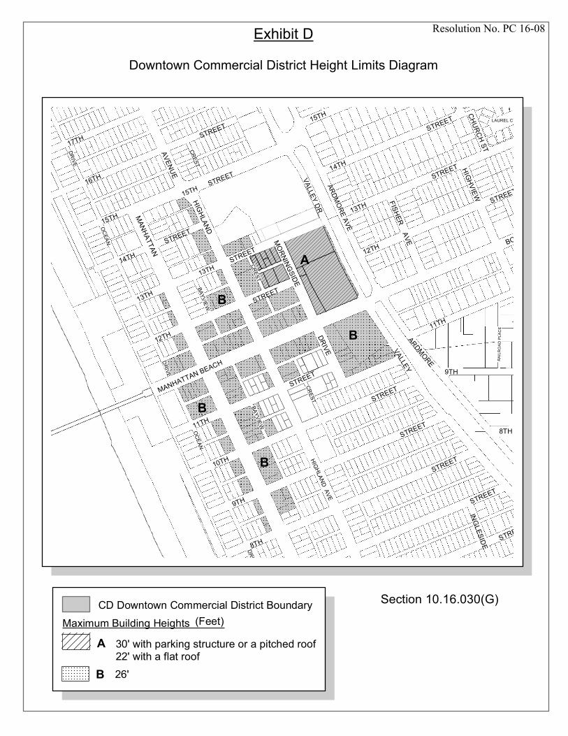
Exhibit D
Downtown Commercial District Height Limits Diagram
15TH
MANHATTAN
STREET16TH
14TH
INGLESIDE
HIGHVIEW
MORNINGSIDE
DEEGAN PLCHURCH STAVENUE
FISHERAVE
13TH STREET
BOULEVARD
STREET
9TH
11TH
10TH
12TH
14TH
8TH
11TH
BAYVIEW
18TH
12TH
STREET
STREET
MANHATTAN BEACH
DRIVE
STREET
STREETSTREET
HIGHLAND15TH
STREET
STREET
CREST
BAYVIEW
CREST
VALLEYARDMORE
17TH
9TH
13TH
CREST
STREET
STREET
STREETSTREET
8TH
DRIVE
OCEAN
DRIVE
OCEAN
DRIVE
RAILR
OAD
PLAC
E
LAUREL CT.
HIGHLANDAVE
13TH
B
B
B
B
AVALLEY DR
ARDMORE AVE
15TH STREET
Section 10.16.030(G)Maximum Building Heights in Feet
26'
30' with parking structure or a pitched roof22' with a flat roof
B
A
CD Downtown Commercial District Boundary (Feet)
Resolution No. PC 16-08