Research Report SERIES - OCPM
54
CURA } Community-University Research Alliance Alliance de recherche communauté-université Research Report SERIES L. Bornstein, Project Director — J. Prince, C. Vandermeulen, Project Coordinators School of Urban Planning Suite 400, Macdonald-Harrington 815 Sherbrooke Street West Montreal, Quebec H3A 2K6 Telephone: +1 (514) 398-4075 Fax: +1 (514) 398-8376 www.mcgill.ca/urbanplanning/mpc Saint Raymond 2011 Baseline Study --DRAFT-- Kraemer, S., Merriman, J., Prince, J., Bornstein, L. School of Urban Planning, McGill University RR12-02E DECEMBER 2012 Abstract Saint-Raymond, a sub-neighbourhood of Notre-Dame-de-Grace and located just a few minutes West of downtown Montreal, lies immediately adjacent two megaprojects, the Turcot Interchange and the new McGill University Health Centre (MUHC). Saint-Raymond, with a small and relatively stable residential population, has a high proportion of non-Canadian-born residents. e neighbourhood is surrounded by significant physical barriers, but these same factors may also have played a role in soften- ing gentrification pressures that have been strongly felt in surrounding areas. e arrival of the MUHC Glen Campus and the reconstruction of both the Décarie Expressway and the Turcot Interchange present a historic opportunity for the area to benefit from changes going on around it and to improve connections with surrounding areas. is report paints a portrait of the neigh- bourhood and highlights the directions in which the neighbourhood may be headed. Cite as Kraemer, S., Merriman, J., Prince, J., Bornstein, L.(2012). “Saint Raymond 2011 Baseline Study”. Research Repot RR12-02E. Montréal: CURA Making Megaprojects Work for Communities - Mégaprojets au service es communautés. More reports and working papers at www.mcgill.ca/urbanplanning/mpc/research/
Transcript of Research Report SERIES - OCPM

CURA } Community-University Research AllianceAlliance de recherche communauté-université
Research Report SERIES
L. Bornstein, Project Director — J. Prince, C. Vandermeulen, Project Coordinators
School of Urban PlanningSuite 400, Macdonald-Harrington815 Sherbrooke Street WestMontreal, Quebec H3A 2K6
Telephone: +1 (514) 398-4075Fax: +1 (514) 398-8376www.mcgill.ca/urbanplanning/mpc
Saint Raymond 2011 Baseline Study--DRAFT--
Kraemer, S., Merriman, J., Prince, J., Bornstein, L.School of Urban Planning, McGill University
RR12-02EDECEMBER 2012
Abstract
Saint-Raymond, a sub-neighbourhood of Notre-Dame-de-Grace and located just a few minutes West of downtown Montreal, lies immediately adjacent two megaprojects, the Turcot Interchange and the new McGill University Health Centre (MUHC). Saint-Raymond, with a small and relatively stable residential population, has a high proportion of non-Canadian-born residents. Th e neighbourhood is surrounded by signifi cant physical barriers, but these same factors may also have played a role in soften-ing gentrifi cation pressures that have been strongly felt in surrounding areas. Th e arrival of the MUHC Glen Campus and the reconstruction of both the Décarie Expressway and the Turcot Interchange present a historic opportunity for the area to benefi t from changes going on around it and to improve connections with surrounding areas. Th is report paints a portrait of the neigh-bourhood and highlights the directions in which the neighbourhood may be headed.
Cite as Kraemer, S., Merriman, J., Prince, J., Bornstein, L.(2012). “Saint Raymond 2011 Baseline Study”. Research Repot RR12-02E.
Montréal: CURA Making Megaprojects Work for Communities - Mégaprojets au service es communautés.
More reports and working papers at www.mcgill.ca/urbanplanning/mpc/research/
Contents
1. INTRODUCTION 31.1. Presentation of study area 41.2. Brief history of Saint-Raymond 51.3. Brief Description of Surrounding Neighbourhoods 6
2. SOCIO-DEMOGRAPHIC ANALYSIS 72.1. Population 72.2. Immigration 92.3. Visible Minorities and Ethnic Origins 92.4. Language 112.5. Educational Levels 122.6. Income and employment 132.7. Housing 162.8. Community resources 182.9. Conclusions: Socio-Demographic Section 20
3. TRANSPORTATION 213.1. Public Transportation 213.2. Pedestrians and Bicycles 243.3. Regional road network 273.4. Circulation Conclusions 31
4. Economic Development 324.1. Main Commercial Arteries 324.2. Commercial Development 354.3. Residential development 394.4. Recent residential development 404.5. Economic Development Conclusions 44
5. POLICY AND PROGRAMS 445.1. Borough plans 445.2. Quartier Vert, Actif et en Santé – Southeastern NDG 475.3. Policy Summary 49
6. CONCLUSION 507. REFERENCES 51

Saint Raymond 2011 Baseline Study. Kraemer, S., et al. Page 3
Saint-Raymond is a sub-neighbourhood of Notre Dame de Grace, located just a few minutes West of downtown Montreal. Nicknamed the Little Little Italy, Saint-Raymond, located at the southern edge of the Côte-des-Neiges/Notre-Dame-de-Grace borough of Montreal, has been and continues to be shaped by larger urban, geographic, economic and political forces at its borders. Th roughout this report, key trends will be highlighted and drawn together to paint a picture of the Saint-Raymond neighbourhood currently as well as highlight the directions in which the neighbourhood may be headed.
Th is report is an update to an unpublished 2005 study of Saint-Raymond, conducted by McGill University urban planning students. Th is report builds on the 2005 information and provides an up-to-date perspective on the challenges and opportunities facing Saint-Raymond, as well as current socio-demographic, economic, and circulation-related trends.
Saint-Raymond has a small and relatively stable residential population, with a high proportion of non-Canadian-born residents. Th e neighbourhood is surrounded by physical barriers including highly traffi cked streets which, combined with a small residential population, make it diffi cult for Saint-Raymond to sustain both commercial and institutional services. However these same factors – small population, high volume streets and poor connections to other neighbourhoods – may also have played a role in soft ening the gentrifi cation pressures which have been strongly felt in surrounding areas.
Saint-Raymond is struggling as a community; most services and amenities used by residents are located outside of the neighbourhood. Moreover, the residential quality of the neighbourhood is negatively aff ected by the prevalence of vehicle-related businesses and light industry located in Saint-Raymond. One solution evoked by policy makers to address the community’s lack of services is to dramatically increase the neighbourhood population: a larger population would boost the small businesses on Upper-Lachine, enable the critical mass required to provide a range of social services and perhaps even justify the return of a local elementary school in the neighbourhood. Others say eff orts should be made to change the character of Saint-Jacques, and replace the used car lots and roofi ng companies with other businesses that are less of a nuisance for residents, making the neighbourhood more inviting. However, these existing businesses, which draw clients from across the City, are economically stable and provide employment in the area. Moreover, the high volume and speed of vehicular traffi c on Saint-Jacques lends itself well to current uses. Planners have suggested using incentives to move these noxious businesses slightly further West on Saint-Jacques, so that these uses and the jobs they create are kept in the neighbourhood, but further away from residents, but these suggestions may be expensive and challenging to implement.
Important changes are happening in the areas immediately adjacent to Saint-Raymond. Th e opening of the new Turcot Interchange in 2017 will likely reduce traffi c volumes on Saint-Jacques especially during rush hour, when this route is borrowed by West Island commuters, but a broad literature on congestion suggests this improvement may only be temporary. With the opening of the McGill University Health Centre (MUHC) Glen Campus in 2015, new traffi c patterns and increased pressures on real estate will start to be felt. While these mega-projects appear to have stalled several key planning initiatives in the area, the long-term future development of Saint-Raymond is sure to be heavily infl uenced by these two projects.
Th e arrival of the MUHC Glen Campus and the reconstruction of both the Décarie Expressway and
1. INTRODUCTION
Saint Raymond 2011 Baseline Study. Kraemer, S., et al. Page 4
the Turcot Interchange present a historic opportunity for the area to benefi t from changes going on around it and to improve connections with surrounding areas. As noted succinctly in an important MUHC social and economic impact assessment report, prepared by Arbour et associés in 2005:
L’implantation d’un équipement de l’envergure du futur Centre universitaire de santé McGill (CUSM) à la cour Glen aura un impact sur le milieu d’insertion d’un point de vue économique. L’ampleur de l’impact dépendra des diff érentes caractéristiques du milieu récepteur, des intentions et du comportement des diff érents intervenants concernés (p.156).
Importantly, the eff ects of these projects on Saint-Raymond will depend on what decisions the diff erent social, economic and political stakeholders in and around the neighbourhood make, and what actions they take. Th ese decisions and actions will aff ect many diff erent aspects of neighbourhood life, including housing aff ordability and gentrifi cation, economic development opportunities, urban integration, speed and volumes of road traffi c, walkability of streets and local employment rates.
Our report provides a comprehensive overview of information about the Saint-Raymond neighbourhood to help orient a variety of stakeholders as they grapple with neighbourhood change.
Th e neighbourhood known as Saint-Raymond, named for the Catholic Parish of Saint-Raymond, is located in the southeastern portion of Notre-Dame-de-Grâce (NDG), which is part of the larger City of Montreal borough of Côte-des-Neiges/Notre-Dame-de-Grâce (CDN/NDG). Saint-Raymond, sometimes also known as “the neighbourhood below the tracks”, was historically an anglophone, working-class residential neighbourhood. Th e aff ordable land available on the southern side of the tracks, especially during the 1910s, attracted many industrial workers working locally. Th roughout its history, strong regional forces have shaped the Saint-Raymond neighbourhood, especially the construction of the CPR railway in 1890 and the construction of the Décarie Expressway in 1964. Before the construction of Highway 720, Saint-Jacques was the main road leading to downtown Montreal, and many of the small and struggling hotels along this artery date from this period. Th e automotive sector, which remains a visible feature of the neighbourhood, was established on Saint-Jacques in the 1920s. Saint-Raymond is also oft en referred to as an Italian neighbourhood, due to large numbers of Italian-born immigrants who settled here in the 1950s.
Over the past few decades, Saint-Raymond has increasingly been home to lower income and, more recently, newly arrived immigrant populations. Today, the area is home to an ethnically-diverse population which includes recent immigrants from all over the world (China, the Caribbean and Africa), in addition to the ageing Italian community. Th is section will present some of the defi ning characteristics of the neighbourhood.
Saint-Raymond is an enclave, blocked in by physical barriers on its northern, southern and eastern borders, which contribute to many of the neighbourhood’s challenges. Th ese physical features include: the Canadian Pacifi c (CP) railway tracks that run along de Maisonneuve to the north, the Saint-Jacques Escarpment to the south, and the Décarie Expressway to the east. Th e western border of the Saint-Raymond neighbourhood is oft en defi ned as boulevard Cavendish, a high volume arterial road. (However, for Census data analysis, the western border of Saint-Raymond is extended, as will be described further on in the report.)
1.1. Presentation of study area
1.1.1. Boundaries
Saint Raymond 2011 Baseline Study. Kraemer, S., et al. Page 5
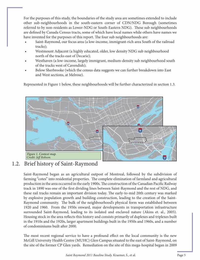
For the purposes of this study, the boundaries of the study area are sometimes extended to include other sub-neighbourhoods in the south-eastern corner of CDN/NDG Borough (sometimes referred to by non-residents as Lower-NDG or South-Eastern NDG). Th ese sub neighbourhoods are defi ned by Canada Census tracts, some of which have local names while others have names we have invented for the purposes of this report. Th e four sub neighbourhoods are: • Saint-Raymond, our focus area (a low-income, immigrant-rich area South of the railroad
tracks);• Westmount Adjacent (a highly educated, older, low density NDG sub neighbourhood
north of the tracks east of Decarie);• Westhaven (a low-income, largely immigrant, medium-density sub neighbourhood south
of the tracks west of Cavendish); • Below Sherbrooke (which the census data suggests we can further breakdown into East
and West sections, at Melrose).
Represented in Figure 1 below, these neighbourhoods will be further characterized in section 1.3.
Saint-Raymond began as an agricultural outpost of Montreal, followed by the subdivision of farming “cotes” into residential properties. Th e complete elimination of farmland and agricultural production in the area occurred in the early 1900s. Th e construction of the Canadian Pacifi c Railway track in 1890 was one of the fi rst dividing lines between Saint-Raymond and the rest of NDG, and these rail tracks remain an important division today. Th e early-to-mid 20th century was marked by explosive population growth and building construction, leading to the creation of the Saint-Raymond community. Th e bulk of the neighbourhood’s physical form was established between 1920 and 1960. From the 1950s onward, major developments in transportation infrastructure surrounded Saint-Raymond, leading to its isolated and enclaved nature (Akins et. al., 2005). Housing stock in the area refl ects this history and consists primarily of duplexes and triplexes built in the 1910s and the 1920s, larger apartment buildings built in the 1950s and 1960s, and a number of condominiums built aft er 2000.
Th e most recent regional service to have a profound eff ect on the local community is the new McGill University Health Centre (MUHC) Glen Campus situated to the east of Saint-Raymond, on the site of the former CP Glen yards. Remediation on the site of this mega-hospital began in 2009
Figure 1. Context map.
1.2. Brief history of Saint-RaymondCredit: Jeff Robson.

Saint Raymond 2011 Baseline Study. Kraemer, S., et al. Page 6
and construction is slated for completion by the end of 2014. Th e MUHC Glen Campus will likely have a profound and lasting eff ect on its surroundings. Th e current and potential eff ects that this new development will have on the neighbourhood have been the subject of much speculation, and will be discussed throughout this report as an update to previous predictions.
Although Saint-Raymond is defi ned by physical barriers, the neighbourhood remains accessible due to its proximity to Vendôme metro station and Sherbrooke Street. In addition to the Falaise Saint-Jacques1 and the railway tracks, other important features in the area surrounding Saint-Raymond include a commercial strip on Sherbooke, Vendôme metro station, high-density residential towers near the intersection of Cavendish and Sherbrooke, as well as a big-box commercial development to the west along Saint-Jacques.
Two of the other sub-neighbourhoods adjacent to Saint-Raymond, Westhaven and Westmount Adjacent, have relatively well defi ned characteristics and their residents would recognize the name we are using, while “Below Sherbrooke” is a sub-neighbourhood we are naming ourselves, for purposes of this report (see fi gure 2). As mentioned elsewhere, we will further break this area down into two parts, at Melrose.
A brief portrait of each of these neighbourhoods will now be presented.
Westhaven: Westhaven, a small neighbourhood, is a historically low-income residential area located to the extreme west of the area of NDG below the tracks, on the border with Montreal West. Th is neighbourhood has been home to elderly residents and students (given its proximity to Concordia’s Loyola Campus) and more recently, large numbers of visible minorities, particularly from the Caribbean. Th is neighbourhood is separated from Saint-Raymond by a large commercial zone between Décarie and Cavendish. Th is neighbourhood is part of the same Census Tract as Saint-Raymond, and analysis will sometimes group these two neighbourhoods together; both are home to large immigrant populations.
Westmount Adjacent: Th is neighbourhood’s name refl ects its proximity to the largely affl uent independent municipality of Westmount. Located above the tracks on the other side of the Décarie expressway near Metro Vendôme, the character of the built environment and the population here more closely resembles that of Westmount than NDG: high levels of university educated residents, majority native English speakers, and low rates of buildings in disrepair. However, this area has been undergoing signifi cant changes in socio-demographic characteristics, as will be presented later in the report.
1.3. Brief Description of Surrounding Neighbourhoods
Figure 2 : Saint-Raymond and Surrounding neighbourhoods.Credit: Jeff Robson.
1 Falaise Saint-Jacques is the term most oft en used, even by Anglophones, to refer to the Saint-Jacques escarpment.
Saint Raymond 2011 Baseline Study. Kraemer, S., et al. Page 7
Th e residential population of the neighbourhood has remained relatively stable over the last 15 years. Saint-Raymond is still a diverse neighbourhood, with high proportions of recent immigrants and an ageing, slowly declining Italian population. Saint-Raymond is home to high proportions of lone-parent families, with more renters than homeowners, and lower than Montreal-average household incomes.
NDG has an unusual demographic pattern, very much like a patchwork quilt. While NDG is highly diverse, with a large immigrant population and high numbers of visible minority residents, immigrants are concentrated in a few sub-neighbourhoods, one which is Saint-Raymond. Many of Saint-Raymond's residents are recent immigrants, meaning they oft en face diffi cult challenges in adjusting to life in a new city and securing employment. Most residents are able to speak at least one offi cial language, however few are native French speakers.
Saint-Raymond has relatively high numbers of children, so schools and daycares are pressing issues. However, because the overall population is low, the elementary school in Saint-Raymond closed many years ago and children in the area must navigate strong barriers to reach schools in other areas. Seniors are also highly concentrated in the neighbourhood, particularly in the traditionally Italian area at the core of Saint-Raymond.
2. SOCIO-DEMOGRAPHIC ANALYSIS
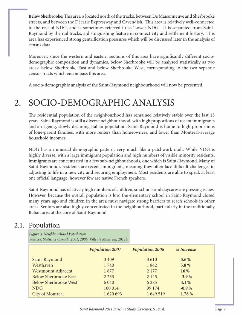
2.1. Population
Below Sherbrooke: Th is area is located north of the tracks, between De Maisonneuve and Sherbrooke streets, and between the Décarie Expressway and Cavendish. Th is area is relatively well-connected to the rest of NDG, and is sometimes referred to as ‘Lower NDG’. It is separated from Saint-Raymond by the rail tracks, a distinguishing feature in connectivity and settlement history. Th is area has experienced strong gentrifi cation pressures which will be discussed later in the analysis of census data.
Moreover, since the western and eastern sections of this area have signifi cantly diff erent socio-demographic composition and dynamics, below Sherbrooke will be analysed statistically as two areas: below Sherbrooke East and below Sherbrooke West, corresponding to the two separate census tracts which encompass this area.
A socio-demographic analysis of the Saint-Raymond neighbourhood will now be presented.
Population 2001 Population 2006 % Increase
Saint-Raymond 3 409 3 610 5.6 %Westhaven 1 740 1 842 5.8 %Westmount Adjacent 1 877 2 177 16 %Below Sherbrooke East 2 233 2 145 -3.9 %Below Sherbrooke West 6 040 6 285 4.1 %NDG 100 014 99 174 -0.9 %City of Montreal 1 620 693 1 649 519 1.78 %
Sources: Statistics Canada 2001, 2006; Ville de Montréal, 2011b.Figure 3. Neighbourhood Population.
Saint Raymond 2011 Baseline Study. Kraemer, S., et al. Page 8
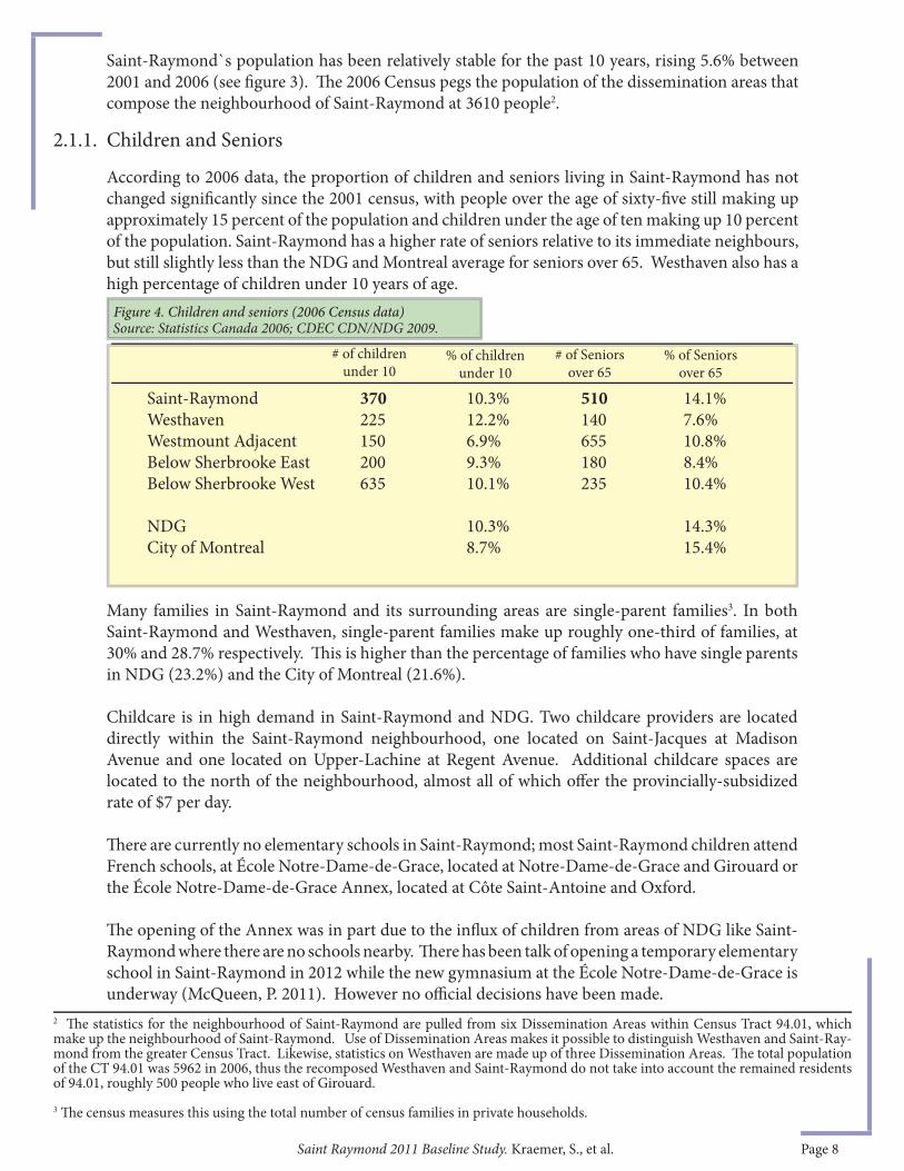
According to 2006 data, the proportion of children and seniors living in Saint-Raymond has not changed signifi cantly since the 2001 census, with people over the age of sixty-fi ve still making up approximately 15 percent of the population and children under the age of ten making up 10 percent of the population. Saint-Raymond has a higher rate of seniors relative to its immediate neighbours, but still slightly less than the NDG and Montreal average for seniors over 65. Westhaven also has a high percentage of children under 10 years of age.
Many families in Saint-Raymond and its surrounding areas are single-parent families3. In both Saint-Raymond and Westhaven, single-parent families make up roughly one-third of families, at 30% and 28.7% respectively. Th is is higher than the percentage of families who have single parents in NDG (23.2%) and the City of Montreal (21.6%).
Childcare is in high demand in Saint-Raymond and NDG. Two childcare providers are located directly within the Saint-Raymond neighbourhood, one located on Saint-Jacques at Madison Avenue and one located on Upper-Lachine at Regent Avenue. Additional childcare spaces are located to the north of the neighbourhood, almost all of which off er the provincially-subsidized rate of $7 per day.
Th ere are currently no elementary schools in Saint-Raymond; most Saint-Raymond children attend French schools, at École Notre-Dame-de-Grace, located at Notre-Dame-de-Grace and Girouard or the École Notre-Dame-de-Grace Annex, located at Côte Saint-Antoine and Oxford.
Th e opening of the Annex was in part due to the infl ux of children from areas of NDG like Saint-Raymond where there are no schools nearby. Th ere has been talk of opening a temporary elementary school in Saint-Raymond in 2012 while the new gymnasium at the École Notre-Dame-de-Grace is underway (McQueen, P. 2011). However no offi cial decisions have been made.
2.1.1. Children and Seniors
Saint-Raymond 370 10.3% 510 14.1%Westhaven 225 12.2% 140 7.6%Westmount Adjacent 150 6.9% 655 10.8%Below Sherbrooke East 200 9.3% 180 8.4%Below Sherbrooke West 635 10.1% 235 10.4%
NDG 10.3% 14.3%City of Montreal 8.7% 15.4%
# of children under 10
% of Seniors over 65
% of children under 10
# of Seniors over 65
Figure 4. Children and seniors (2006 Census data)
Saint-Raymond`s population has been relatively stable for the past 10 years, rising 5.6% between 2001 and 2006 (see fi gure 3). Th e 2006 Census pegs the population of the dissemination areas that compose the neighbourhood of Saint-Raymond at 3610 people2.
2 Th e statistics for the neighbourhood of Saint-Raymond are pulled from six Dissemination Areas within Census Tract 94.01, which make up the neighbourhood of Saint-Raymond. Use of Dissemination Areas makes it possible to distinguish Westhaven and Saint-Ray-mond from the greater Census Tract. Likewise, statistics on Westhaven are made up of three Dissemination Areas. Th e total population of the CT 94.01 was 5962 in 2006, thus the recomposed Westhaven and Saint-Raymond do not take into account the remained residents of 94.01, roughly 500 people who live east of Girouard.3 Th e census measures this using the total number of census families in private households.
Source: Statistics Canada 2006; CDEC CDN/NDG 2009.
Saint Raymond 2011 Baseline Study. Kraemer, S., et al. Page 9
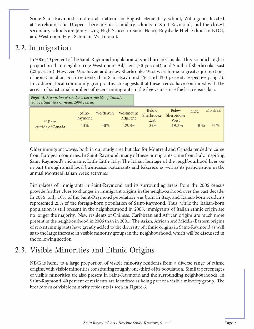
In 2006, 43 percent of the Saint-Raymond population was not born in Canada. Th is is a much higher proportion than neighbouring Westmount Adjacent (30 percent), and South of Sherbrooke East (22 percent). However, Westhaven and below Sherbrooke West were home to greater proportions of non-Canadian born residents than Saint-Raymond (50 and 49.3 percent, respectively, fi g 5). In addition, local community group outreach suggests that these trends have continued with the arrival of substantial numbers of recent immigrants in the fi ve years since the last census data.
43% 50% 29.8% 22% 49.3% 40% 31%
Older immigrant waves, both in our study area but also for Montreal and Canada tended to come from European countries. In Saint-Raymond, many of these immigrants came from Italy, inspiring Saint-Raymond’s nickname, Little Little Italy. Th e Italian heritage of the neighbourhood lives on in part through small local businesses, restaurants and bakeries, as well as its participation in the annual Montreal Italian Week activities
Birthplaces of immigrants in Saint-Raymond and its surrounding areas from the 2006 census provide further clues to changes in immigrant origins in the neighbourhood over the past decade. In 2006, only 10% of the Saint-Raymond population was born in Italy, and Italian-born residents represented 25% of the foreign-born population of Saint-Raymond. Th us, while the Italian-born population is still present in the neighbourhood in 2006, immigrants of Italian ethnic origin are no longer the majority. New residents of Chinese, Caribbean and African origins are much more present in the neighbourhood in 2006 than in 2001. Th e Asian, African and Middle-Eastern origins of recent immigrants have greatly added to the diversity of ethnic origins in Saint-Raymond as well as to the large increase in visible minority groups in the neighbourhood, which will be discussed in the following section.
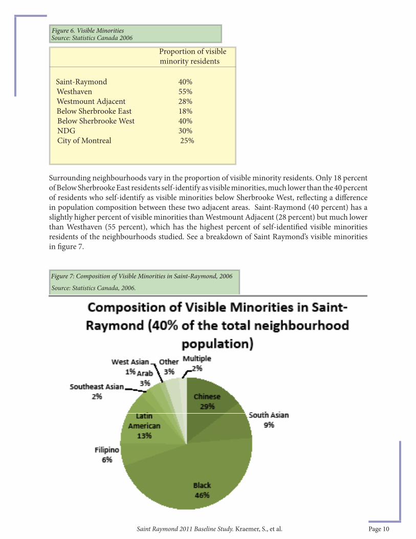
NDG is home to a large proportion of visible minority residents from a diverse range of ethnic origins, with visible minorities constituting roughly one-third of its population. Similar percentages of visible minorities are also present in Saint-Raymond and the surrounding neighbourhoods. In Saint-Raymond, 40 percent of residents are identifi ed as being part of a visible minority group. Th e breakdown of visible minority residents is seen in Figure 6.
Montreal
2.2. Immigration
43% 50% 29.8% 22% 49.3% 40% 31%
MontrealSaint-
RaymondWesthaven Westmount
Adjacent
BelowSherbrooke
East
BelowSherbrooke
West
Figure 5. Proportion of residents born outside of Canada
NDG
% Born outside of Canada
Source: Statistics Canada, 2006 census.
2.3. Visible Minorities and Ethnic Origins
Some Saint-Raymond children also attend an English elementary school, Willingdon, located at Terrebonne and Draper. Th ere are no secondary schools in Saint-Raymond, and the closest secondary schools are James Lyng High School in Saint-Henri, Royalvale High School in NDG, and Westmount High School in Westmount.
Saint Raymond 2011 Baseline Study. Kraemer, S., et al. Page 10
Surrounding neighbourhoods vary in the proportion of visible minority residents. Only 18 percent of Below Sherbrooke East residents self-identify as visible minorities, much lower than the 40 percent of residents who self-identify as visible minorities below Sherbrooke West, refl ecting a diff erence in population composition between these two adjacent areas. Saint-Raymond (40 percent) has a slightly higher percent of visible minorities than Westmount Adjacent (28 percent) but much lower than Westhaven (55 percent), which has the highest percent of self-identifi ed visible minorities residents of the neighbourhoods studied. See a breakdown of Saint Raymond’s visible minorities in fi gure 7.
Figure 6. Visible MinoritiesSource: Statistics Canada 2006
Saint-Raymond 40%Westhaven 55%Westmount Adjacent 28%Below Sherbrooke East 18%Below Sherbrooke West 40%NDG 30%City of Montreal 25%
Proportion of visible minority residents
Figure 7: Composition of Visible Minorities in Saint-Raymond, 2006
Source: Statistics Canada, 2006.

Saint Raymond 2011 Baseline Study. Kraemer, S., et al. Page 11
Only a small minority of Saint-Raymond residents are native French speakers; English or a non-offi cial language are the predominant native languages of all the neighbourhood residents. In Saint-Raymond, a striking 46 percent of residents are neither French nor English native language speakers; 14% are native French language speakers. Other language distinctions include a very high number of native English speakers (50%) in Westmount Adjacent and in Below Sherbrooke East. Below Sherbrooke East also has the highest percentage of French native language speakers (34.5%) of the neighbourhoods (see fi gure 8).
English French Non-offi cial Multiple responsesWestmount Adjacent 50% 22% 27% 1%Below Sherbrooke East 42% 34.5% 23% 0.5%Below Sherbrooke West 33.5% 17% 46% 3.5%Saint-Raymond 36% 14% 46% 4%Westhaven 37% 17% 43.5% 2%
2.4. Language
Figure 8. Mother Tongue by percentage of neighbourhood populations, 2006
Although declining in numbers, the Italian Community in Saint-Raymond still hosts a bocci tournament during the annual Italian Festival which takes place throughout Montreal in at the beginning of August every year. Th ese bocce courts, located at Oxford Park are an important place for older Italians to socialize, and thus serve an important social function in the ageing Italian community (see Burns et al., 2012).
Aft er 81 years of being an Anglican Church, St. Savior’s, built in 1925, was sold due to low membership and a need for repairs to the church. Th e church was bought by a Romanian orthodox parish which had formerly been sharing space in Snowdon district. Th is new tenant in the area, the Romanian Orthodox Church, had its fi rst mass in 2009, and members are currently fundraising to expand the church. Although Romanians are not yet a strong presence in Saint-Raymond, the choice of locations for the church may refl ect an increase in Romanian immigrants in the general area.
Sidebar 1: CRUCIAL LOCAL GATHERING PLACES
Th e diversity of the neighbourhood can be physically observed through various displays of national identity, such as the numerous Italian fl ags displayed in retail stores in the north-eastern part of Saint-Raymond. Many shops also display signs with writing in languages of origin, such as Italian or Mandarin. Some of the gathering places for local residents of diverse ethnic origins are illustrated in Sidebar 1.
Residents of Saint-Raymond and surrounding neighbourhoods identify as having a diverse array of ethnic origins and nationalities, including Canadian, the British Isles (English, Irish, Scottish), French, Caribbean (Jamaican, Trinidadian, Guyanese), African, Chinese, German, Polish, Filipino, Romanian, South Asian and Iranian. Th e diverse ethnic origins of Saint-Raymond residents refl ect the high percentage of visible minority and non-Canadian born residents. Overall, the Chinese population has seen a signifi cant increase in the area, which refl ects the overall rapid increase in Chinese immigrants in NDG as a whole (CDEC CDN/NDG, 2009).
Source: Statistics Canada, 2006.
Saint Raymond 2011 Baseline Study. Kraemer, S., et al. Page 12
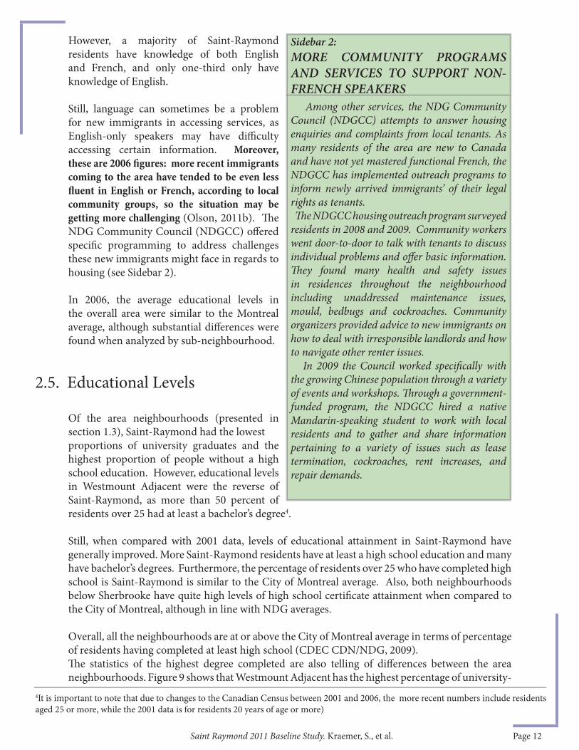
Among other services, the NDG Community Council (NDGCC) attempts to answer housing enquiries and complaints from local tenants. As many residents of the area are new to Canada and have not yet mastered functional French, the NDGCC has implemented outreach programs to inform newly arrived immigrants’ of their legal rights as tenants. Th e NDGCC housing outreach program surveyed residents in 2008 and 2009. Community workers went door-to-door to talk with tenants to discuss individual problems and off er basic information. Th ey found many health and safety issues in residences throughout the neighbourhood including unaddressed maintenance issues, mould, bedbugs and cockroaches. Community organizers provided advice to new immigrants on how to deal with irresponsible landlords and how to navigate other renter issues. In 2009 the Council worked specifi cally with the growing Chinese population through a variety of events and workshops. Th rough a government-funded program, the NDGCC hired a native Mandarin-speaking student to work with local residents and to gather and share information pertaining to a variety of issues such as lease termination, cockroaches, rent increases, and repair demands.
Sidebar 2: MORE COMMUNITY PROGRAMS AND SERVICES TO SUPPORT NON-FRENCH SPEAKERS
Of the area neighbourhoods (presented in section 1.3), Saint-Raymond had the lowest proportions of university graduates and the highest proportion of people without a high school education. However, educational levels in Westmount Adjacent were the reverse of Saint-Raymond, as more than 50 percent of residents over 25 had at least a bachelor’s degree4.
Still, when compared with 2001 data, levels of educational attainment in Saint-Raymond have generally improved. More Saint-Raymond residents have at least a high school education and many have bachelor’s degrees. Furthermore, the percentage of residents over 25 who have completed high school is Saint-Raymond is similar to the City of Montreal average. Also, both neighbourhoods below Sherbrooke have quite high levels of high school certifi cate attainment when compared to the City of Montreal, although in line with NDG averages.
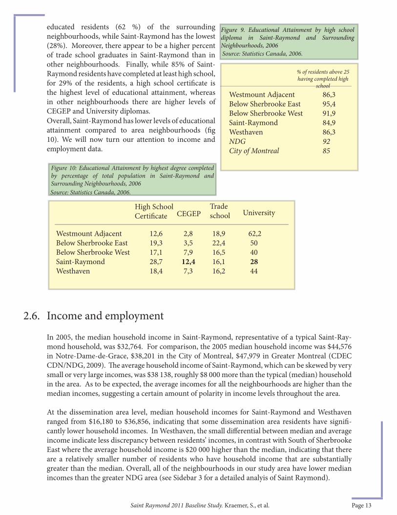
Overall, all the neighbourhoods are at or above the City of Montreal average in terms of percentage of residents having completed at least high school (CDEC CDN/NDG, 2009). Th e statistics of the highest degree completed are also telling of diff erences between the area neighbourhoods. Figure 9 shows that Westmount Adjacent has the highest percentage of university-
2.5. Educational Levels
However, a majority of Saint-Raymond residents have knowledge of both English and French, and only one-third only have knowledge of English.
Still, language can sometimes be a problem for new immigrants in accessing services, as English-only speakers may have diffi culty accessing certain information. Moreover, these are 2006 fi gures: more recent immigrants coming to the area have tended to be even less fl uent in English or French, according to local community groups, so the situation may be getting more challenging (Olson, 2011b). Th e NDG Community Council (NDGCC) off ered specifi c programming to address challenges these new immigrants might face in regards to housing (see Sidebar 2).
In 2006, the average educational levels in the overall area were similar to the Montreal average, although substantial diff erences were found when analyzed by sub-neighbourhood.
4It is important to note that due to changes to the Canadian Census between 2001 and 2006, the more recent numbers include residents aged 25 or more, while the 2001 data is for residents 20 years of age or more)
Saint Raymond 2011 Baseline Study. Kraemer, S., et al. Page 13
2.6. Income and employment
educated residents (62 %) of the surrounding neighbourhoods, while Saint-Raymond has the lowest (28%). Moreover, there appear to be a higher percent of trade school graduates in Saint-Raymond than in other neighbourhoods. Finally, while 85% of Saint-Raymond residents have completed at least high school, for 29% of the residents, a high school certifi cate is the highest level of educational attainment, whereas in other neighbourhoods there are higher levels of CEGEP and University diplomas.
Source: Statistics Canada, 2006.
Westmount Adjacent 86,3Below Sherbrooke East 95,4Below Sherbrooke West 91,9Saint-Raymond 84,9Westhaven 86,3NDG 92City of Montreal 85
% of residents above 25 having completed high
school
Figure 9. Educational Attainment by high school diploma in Saint-Raymond and Surrounding Neighbourhoods, 2006
In 2005, the median household income in Saint-Raymond, representative of a typical Saint-Ray-mond household, was $32,764. For comparison, the 2005 median household income was $44,576 in Notre-Dame-de-Grace, $38,201 in the City of Montreal, $47,979 in Greater Montreal (CDEC CDN/NDG, 2009). Th e average household income of Saint-Raymond, which can be skewed by very small or very large incomes, was $38 138, roughly $8 000 more than the typical (median) household in the area. As to be expected, the average incomes for all the neighbourhoods are higher than the median incomes, suggesting a certain amount of polarity in income levels throughout the area.
At the dissemination area level, median household incomes for Saint-Raymond and Westhaven ranged from $16,180 to $36,856, indicating that some dissemination area residents have signifi -cantly lower household incomes. In Westhaven, the small diff erential between median and average income indicate less discrepancy between residents’ incomes, in contrast with South of Sherbrooke East where the average household income is $20 000 higher than the median, indicating that there are a relatively smaller number of residents who have household income that are substantially greater than the median. Overall, all of the neighbourhoods in our study area have lower median incomes than the greater NDG area (see Sidebar 3 for a detailed analyis of Saint Raymond).
Figure 10: Educational Attainment by highest degree completed by percentage of total population in Saint-Raymond and Surrounding Neighbourhoods, 2006
High School Certifi cate
Trade school UniversityCEGEP
Westmount Adjacent 12,6 2,8 18,9 62,2Below Sherbrooke East 19,3 3,5 22,4 50Below Sherbrooke West 17,1 7,9 16,5 40Saint-Raymond 28,7 12,4 16,1 28Westhaven 18,4 7,3 16,2 44
Overall, Saint-Raymond has lower levels of educational attainment compared to area neighbourhoods (fi g 10). We will now turn our attention to income and employment data.
Source: Statistics Canada, 2006.

Saint Raymond 2011 Baseline Study. Kraemer, S., et al. Page 14
A 2008 report analyzing the area in relation to the surrounding areas, published by the Direction de santé publique (Khun et al., 2008) nuances the indicators of material and social disadvantage to provide a diagnosis of the sectors covered by the CSSSs. Th ey use a complex methodology to produce this analysis, which some consider controversial, the Pampalon index. As demonstrated by Figures 11 and 12 below, Saint-Raymond is largely characterized as being both materially and socially disadvantaged. Two areas are marked as being materially but not socially disadvantaged, which correspond to the Italian node to the East of the neighbourhood and another smaller area to the west of the area, beginning just south of the train tracks (Khun et al., 2008).
Th is corresponds to 55 percent of the population (see Figure 12 below) of Saint-Raymond and Westhaven qualifying as being “materially and socially disadvantaged”, 30 percent being socially but not materially disadvantaged, and 8 percent as being materially but not socially disadvantaged.
Th is level of analysis makes evident how this sub-neighbourhood compares to other areas: Saint-Raymond is one of the most disadvantaged areas in NDG when the confl uence of material and social factors are taken into account (Khun et al., 2008).
Sidebar 3: MOST SAINT RAYMOND RESIDENTS “DISADVANTAGED”, ACCORDING TO 2008 PUBLIC HEALTH STUDY
Figure 11: Report on disadvantaged areas of Montreal - Analysis by Dissemination areas.
Source: Direction de la santé publique.
Figure 12: Report on disadvantaged areas of Montreal - Analysis of health care services’ (CLSC) territorial distinctions.
Source: Direction de la santé publique.

Saint Raymond 2011 Baseline Study. Kraemer, S., et al. Page 15
Turning to unemployment, diff erences between the neighbourhoods are again apparent (Figure 13). Counting only the people over 15 years of age who are part of the labour force, Westhaven clearly has the highest unemployment rate (18%), three times the unemployment rate of West-mount Adjacent. Below Sherbrooke West, Saint-Raymond and Westhaven all have unemployment rates which are above the NDG average (fi g 14); however, they also have a lower percentage of res-idents over age 15 actively part of the work force.
Saint-Raymond in particular has a high percentage of children and of elderly in its population, in addition to the lowest percentage of university educated residents, half that of Westmount Adjacent residents. Saint-Raymond is also very diff erent from Westmount Adjacent and below Sherbrooke East in terms of the immigrant population; like Westhaven, Saint-Raymond percentages of visible minority residents and residents whose native language is other than French or English are much higher than surrounding areas.
Below Sherbrooke West also resembles Westhaven and Saint-Raymond in regards to the immigrant population as well as average and median household income. Th ere thus appears to be signifi cant similarities between below Sherbrooke East and Westmount Adjacent, in terms of population characteristics.
Overall, defi ning trends in Saint-Raymond’s socio-economic character include a signifi cant recent increase in the Chinese population as well as in other visible minority groups, which has changed the Italian-dominated character of the neighbourhood. Moreover, high-school level educational attainment has increased in Saint-Raymond, although university diploma rates remain substantially lower than surrounding neighbourhoods.
Saint-Raymond, Westhaven and below Sherbrooke West are all struggling with poverty-related challenges. We will now turn our attention to the ways in which these challenges are being manifested with regards to a rapidly evolving housing market and other major changes occurring nearby.
Saint-RaymondWesthaven Westmount Adjacent Below Sherbrooke East Below Sherbrooke West NDG Montreal
$30 971 $23 562 $26 753 $40 717 $29 573 $44 576 $38 201
$38 138 $26 273 $39 568 $60 446 $36 958 $58 960 $51 811
Figure 13. Average and Median Household Incomes (2005) Source: Statistics Canada, 2006.
Median Income Average Income
12.3 18.3 6.2 7.5 12.3 9 9.2
Figure 14: Unemployment rate for persons 15 years of age and older (in the workforce), 2006Source: Statistics Canada, 2006.
Saint-Raymond Westhaven Westmount Adjacent Below Sherbrooke East Below Sherbrooke West NDG Montreal
Note: Unemployment rate applies to persons 15 years of age and older in the workforce.
Figure 13. Average and Median Household Incomes (2005) Source: Statistics Canada, 2006.
Saint Raymond 2011 Baseline Study. Kraemer, S., et al. Page 16
Historically an aff ordable area to live for low-income people, Saint-Raymond has seen rental costs go up in recent years, with increasing average rents, and an ever larger percentage of residents spending 30% or more of their income on rent.
Moreover, the vast majority of residents in Saint-Raymond are renters, with a smaller number who own their own homes. Rising housing costs put diff erent pressures on these diff erent groups, but in general, rising prices benefi t home-owners and make it harder for renters. Some characteristics of the housing market in Saint-Raymond will now be presented.
Saint-Raymond has a high percentage of renter-occupied households, making it more vulnerable to rises in rental prices. Th e proportion of renter-occupied households in Saint-Raymond and Westhaven was 81.6 percent in 2006, which is considerably higher than the city-wide average (62.1 percent) and the highly gentrifi ed Plateau (73.8 percent) (Twigge-Molecey, 2009).
A considerably lower number of renter-occupied households was found in Westmount Adjacent, where only 66 percent of households were renter-occupied (Twigge-Molecey, 2009). Th is area also had a better quality building stock and higher average income levels than the other sub-neighbour-hoods, with an overall profi le perhaps closer to Westmount than its NDG counterparts.
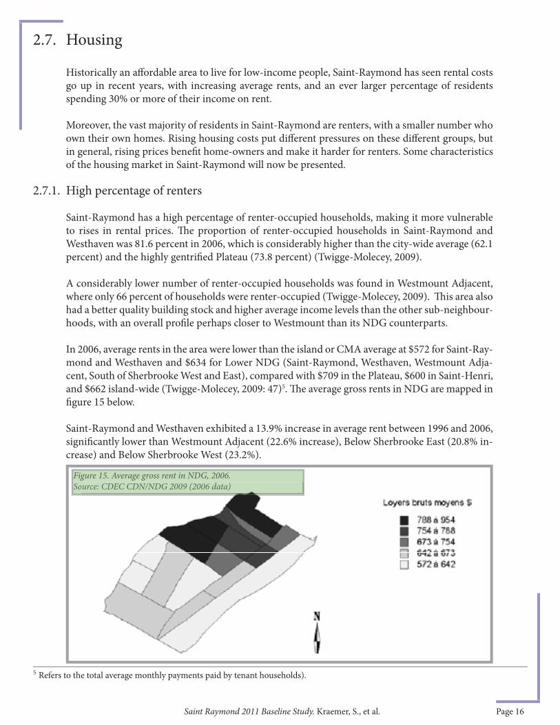
In 2006, average rents in the area were lower than the island or CMA average at $572 for Saint-Ray-mond and Westhaven and $634 for Lower NDG (Saint-Raymond, Westhaven, Westmount Adja-cent, South of Sherbrooke West and East), compared with $709 in the Plateau, $600 in Saint-Henri, and $662 island-wide (Twigge-Molecey, 2009: 47)5. Th e average gross rents in NDG are mapped in fi gure 15 below.
Saint-Raymond and Westhaven exhibited a 13.9% increase in average rent between 1996 and 2006, signifi cantly lower than Westmount Adjacent (22.6% increase), Below Sherbrooke East (20.8% in-crease) and Below Sherbrooke West (23.2%).
2.7. Housing
2.7.1. High percentage of renters
5 Refers to the total average monthly payments paid by tenant households).
Figure 15. Average gross rent in NDG, 2006.Source: CDEC CDN/NDG 2009 (2006 data)Figure 15. Average gross rent in NDG, 2006.Source: CDEC CDN/NDG 2009 (2006 data)

Saint Raymond 2011 Baseline Study. Kraemer, S., et al. Page 17
While as of 2006, Saint-Raymond and Westhaven still had the lowest rents in NDG, at between $572 and $642 a month, the area we are calling Below Sherbrooke had average gross rents in the second highest bracket, at $754-788 per month, even higher than Westmount Adjacent, at $673-754 a month.
Th e increasing cost of housing presents an ongoing challenge to renters in our study area. In Saint-Raymond, since 2006, between 40 and 45 percent of renter households were spending more than 30 percent of their income on rent. In neighbouring Westmount Adjacent, the proportion of renters spending 30 percent of more of their income on monthly rent was more than 50 percent: not a typical Westmount profi le.Th ese diff erences are represented in fi gure 16 below.
It is important to consider again the percentage of renters to owners, to fully appreciate these num-bers: 4 out of 5 households in Saint-Raymond rent, compared with just over 3 out of 5 for West-mount Adjacent, as noted earlier in this report. Th us, approximately 840 households pay more than 30% of their household income on rent, in Saint Raymond.
In addition to increasing rents, average dwelling values have risen at a higher rate in Lower-NDG than city-wide during the ten-year period from 1996 to 2006. In 2006 homeowners in the area were struggling to aff ord their homes, almost 30 percent of homeowners were spending 30 percent or more of their household incomes on the cost of shelter (Twigge-Molecey, 2009).
In 1996, the average value of a dwelling in Lower-NDG was $139,969, while in 2006, this value had increased to $339,911, an increase of 143%. By comparison, over this same period dwelling values on the Island of Montreal increased by 92% (Twigge-Molecey, 2009). By 2006, average dwelling values in Lower NDG were higher than those in Saint-Henri or the Plateau. In Saint-Raymond and Westhaven, there was a decrease in homeownership between 1996 and 2006 of approximately 2%, with about 17 % of residents owning their home.
Source: CDEC CDN/NDG, 2009.
It is interesting to note that Westmount Adjacent spends a higher percentage of their income on rent, although the rents are lower than Below Sherbrooke, which suggests that Below Sherbrooke has a more affl uent community (higher rents, lower percentage of income spent on rent) than Westmount Adjacent. Th is conclusion is also supported by average household income data, cited elsewhere in this report.
2.7.2. Rising dwelling values in Lower-NDG
Figure 16. Proportion of households spending 30% or more of household income on housing.
Saint Raymond 2011 Baseline Study. Kraemer, S., et al. Page 18
Although residents face substantial economic challenges, summarized in the previous section, Saint-Raymond has a true neighbourhood feel. A good-sized community centre and major public green space, Parc Georges-Saint Pierre, known locally as Oxford Park, serve as important centres for the neighbourhood, both as social gathering spaces and activity centres. Saint-Raymond is also served by a number of community groups and resources, some of which are physically located in the neighbourhood and others not; Saint-Raymond has also recently lost some key community groups that have had to relocate elsewhere in NDG when they lost their community space at a local Catholic church. Th e parks, community gardens and some of the community organizations will be presented in the following section.
Saint-Raymond’s largest public space is Parc Georges-Saint-Pierre, oft en called Oxford Park, lo-cated between Upper-Lachine, Saint-Jacques, Oxford and Old Orchard. Th is multi-use park in-cludes a number of recreational features such as a soccer fi eld, baseball diamond, outdoor skating rink, playground and picnic area, and is also the location of the Saint-Raymond Community Cen-tre. Th is park hosts the previously mentioned Italian festival and bocce tournament. In the last two years several improvements have been made, including redoing the playgrounds and the addition of a basketball court. Moreover, the Borough mayor has also proposed plans to add a children’s wading pool area in 2012 (McQueen, 2011).
Oxford Park also contains a City of Montreal community garden with 21 garden plots located at Oxford and Upper-Lachine and a collective garden operated by resident-volunteers that is part of the Victory Garden Network of Action communiterre, an NDG community group. In addition, many residents, especially members of the Italian community, have private gardens for growing food. While there is a small grocery store and some dépanneurs, it is diffi cult to fi nd good quality fresh fruits and vegetables in Saint-Raymond (CEUM, 2011).
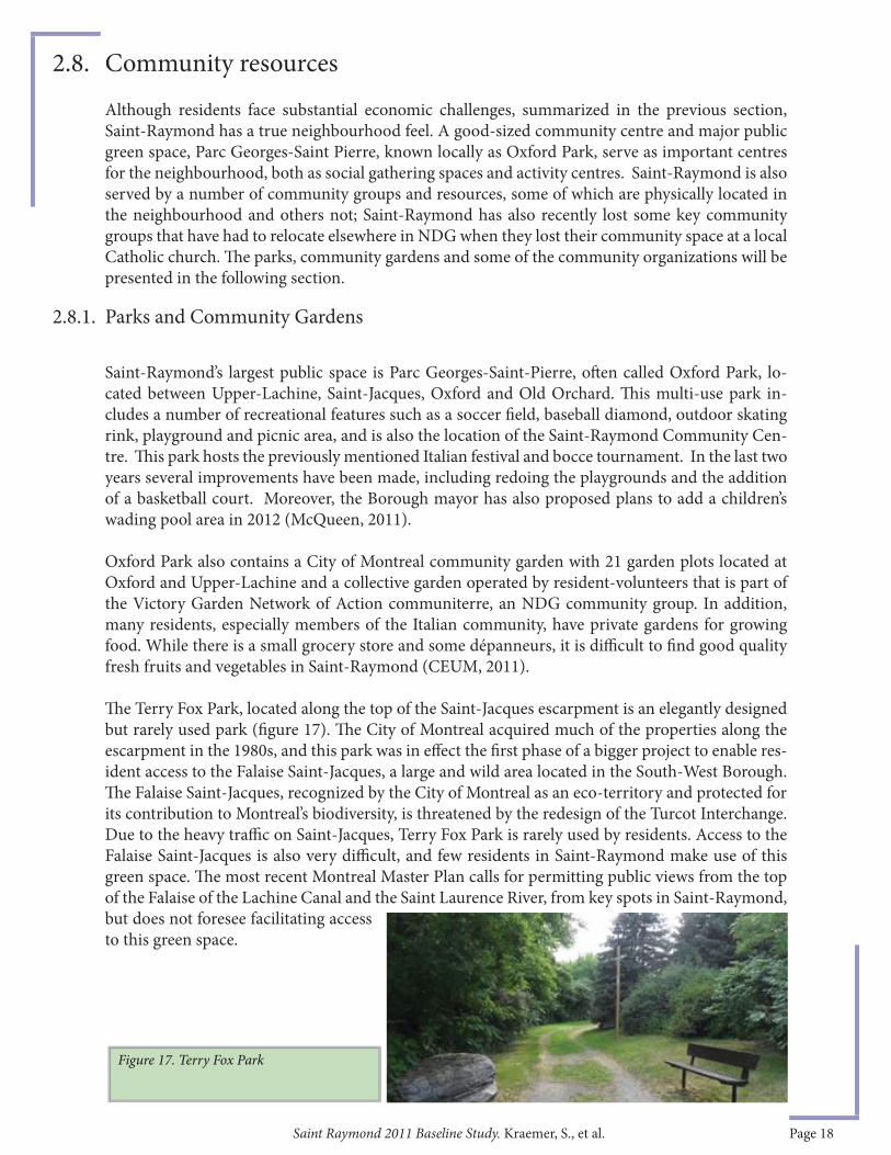
Th e Terry Fox Park, located along the top of the Saint-Jacques escarpment is an elegantly designed but rarely used park (fi gure 17). Th e City of Montreal acquired much of the properties along the escarpment in the 1980s, and this park was in eff ect the fi rst phase of a bigger project to enable res-ident access to the Falaise Saint-Jacques, a large and wild area located in the South-West Borough. Th e Falaise Saint-Jacques, recognized by the City of Montreal as an eco-territory and protected for its contribution to Montreal’s biodiversity, is threatened by the redesign of the Turcot Interchange. Due to the heavy traffi c on Saint-Jacques, Terry Fox Park is rarely used by residents. Access to the Falaise Saint-Jacques is also very diffi cult, and few residents in Saint-Raymond make use of this green space. Th e most recent Montreal Master Plan calls for permitting public views from the top of the Falaise of the Lachine Canal and the Saint Laurence River, from key spots in Saint-Raymond, but does not foresee facilitating access to this green space.
2.8. Community resources
2.8.1. Parks and Community Gardens
Figure 17. Terry Fox Park
Saint Raymond 2011 Baseline Study. Kraemer, S., et al. Page 19
NDG Community Council (NDGCC)
Saint-Raymond has historically had a number of active community groups working to improve the quality of life for residents. Over the past 5 years, the NDG Community Council has played an ever-more important role in the neighbourhood, supporting work on the ground and citizen groups. Th e Community Council, active in NDG for seventy years, animates a number of thematic community meetings which bring together organisations in NDG: the NDG Round Table meetings (similar to the Tables de concertation in other neighbourhoods) are convened roughly four times a year and draw approximately thirty organizations.
Th e NDG 2020 (or Assemblée publique 2020) is an innovative public assembly run by the NDGCC which meets roughly eight times a year and allows citizens to express their thoughts on the direc-tion of the neighbourhood or on a particular issue aff ecting the neighbourhood. Th ese assemblies allow local groups, public bodies and residents to discuss major issues and developments in their neighbourhood and work in a concerted manner by sharing information on community initiatives. NDG 2020 is a made-in-NDG mechanism for galvanizing community action.
Th e NDG Community Council has actively supported the Saint-Raymond Residents’ Association. Th e Council is also an active partner in the Quartier Vert process (described later in this report) and in the Interneighbourhood Coalition (CIQ) and Community University Research Alliance (CURA), whose main preoccupation is the arrival of the new mega-hospital in a rail yard immedi-ately to the East of Saint-Raymond. Th ese projects and activities will have an impact on the future development of Saint-Raymond.
Saint-Raymond Community Centre
Th e Centre communautaire de Saint-Raymond is located on Upper-Lachine at Oxford Avenue. Th is centre opened in 2006 and is managed by Comité Jeunesse NDG, a non-profi t organization in existence since 1981 that works in partnership with the NDG-CDN Borough. Th e community centre off ers a variety of sport and recreational programs, as well as specifi c programs for school age children.
NDG Food Depot
Th e NDG Food Depot, a food bank located just north of Saint-Raymond at the corner of de Mai-sonneuve and Oxford, has been serving Saint-Raymond and the rest of NDG since the mid-1980s. Current services include the Good Food Box, Emergency Food Baskets, free cooking classes, a weekly drop-in for seniors, and jobs and skills workshops and assistance. Th e Good Food Box is a program that provides high quality fruits and vegetable boxes twice per month at various neigh-bourhood drop off points. Emergency Food Baskets, which provide 2.5 days worth of healthy and nutritional food, are available up to twice a month to individuals and families living in certain NDG neighbourhoods.
Action communiterre
A non-profi t organization founded in 1997 and currently located on Sherbrooke at Kensington Avenue, Action communiterre is dedicated to raising public awareness about food securing and
2.8.2. Community organizations

Saint Raymond 2011 Baseline Study. Kraemer, S., et al. Page 20
urban agriculture, as well as improving the community’s access to healthy produce (Action com-muniterre, 2011). Action communiterre manages the Victory Garden Network, which includes ten organic gardens located throughout NDG. Th is organization also off ers a variety activities includ-ing inter-generational cooking, gardening workshops, and nutritional information.
Saint-Raymond Residents Association (SRRA)
Th is association, composed of home-owners and renters, was formed in 2005, partly in response to the announcement of the McGill University Health Centre, and in anticipation of changes to the neighbourhood, particularly in regards to traffi c and access to the rest of NDG. Th e association continues to exist but has been less active recently.
Overall, the Saint-Raymond population has increased moderately over the past few years, most particularly due to new condominium infi ll projects, with an estimated 3610 people in 2006 (plus a few hundred since then). Yet, despite this modest growth, Saint-Raymond is still relatively small and isolated, making it diffi cult to support local amenities and services and a vibrant local econ-omy. Residents of Saint-Raymond still have to travel north to Sherbrooke to access basic services such as banks, pharmacies and other services.
Th e two most important changes in Saint-Raymond over the past decade are a substantial increase in the visible minority immigrant population, and a spike in education attainment levels. Saint-Ray-mond has a highly diverse residential population which includes a high proportion of people born outside of Canada who speak many diff erent mother tongues.
While people of Italian origin still make up 10 percent of the total Saint-Raymond population, this proportion of the population is both ageing and declining in numbers. New immigrants in the area are primarily of Caribbean, African and Chinese origins. Some 40% of Saint Raymond residents are also visible minorities, compared with 25% in Montreal as a whole.
Strikingly, while the majority of people living in Saint-Raymond have knowledge of at least one offi cial language, only 14% are native French language speakers. In 2006, nearly half of residents speak non-offi cial languages as their mother tongue, neither French nor English, similar to other Montreal neighbourhoods like Cote-des-Neiges.
Th e median household income in Saint-Raymond is substantially lower than the rest of NDG. A huge majority of residents are renters (82%), much more than the Montreal average (62%), and the neighbourhood is also home to a higher than average proportion of single-parent households.
However, via a variety of local initiatives, some eff ort is being made to tackle pressing issues like poverty, tenants’ rights, community services and neighbourhood connectivity. Rising housing costs and key indicators show that gentrifi cation is occurring in neighbourhoods surrounding Saint-Ray-mond, especially just to the north of the area, as described later in section 4.3.1: planning, policies and community action in Saint Raymond will continue to respond to these larger urban forces.Th e neighbourhood of Saint-Raymond will continue to be shaped by outside forces including the large-scale projects currently under construction at its borders. We will now turn to transportation and circulation in the area for more insights into these vectors of change.
2.9. Conclusions: Socio-Demographic Section
Saint Raymond 2011 Baseline Study. Kraemer, S., et al. Page 21
Th e following section provides a detailed analysis of the regional road network, public transpor-tation routes, as well as pedestrian and bicycle routes. Major transportation routes and corridors outside Saint-Raymond will be included in analysis, as these routes contribute to the greater con-text of vehicular, pedestrian and public transportation links.
Major transportation features for the area include heavy transiting traffi c during peak hours, fewer vehicle trips and lower car ownership as compared with NDG as a whole. Overall, strong barriers make pedestrian and cycling diffi cult and/or unappealing. While some transport issues continue to aff ect Saint-Raymond (notably the impending construction of the Turcot Interchange and the start of construction of the MUHC Glen Campus), a major eff ort to improve active transport has been launched, the 2011 South-Eastern NDG Quartier vert actif et en santé (QVAS) project developed by Mobiligo in partnership with the NDG-CDN Borough with support from the Urban Ecology Centre and the Coalition québecoise de la problématique du poids as part of the Montreal Urban Ecology Centre QVAS initiative6.
6 QVAS Th e Quartier vert, actif et en santé (QVAS) project, an initiative of Centre d’ecologie urbaine, is a multi-step program which solicits community participation in brainstorming solutions to circulation problems. Th is research and problem-solving project has been conducted in four neighbourhoods in Montreal, most recently in south-eastern NDG. As part of the QVAS, sometimes referred to in English as the Green, Active, Healthy Neighbourhoods Project, area residents are involved in diagnosing circulation problems and conducting research on the area. Solutions to problem areas are then brainstormed by a variety of stakeholders. Th e South-eastern NDG QVAS project began in the summer of 2010 and was completed in November 2011.
Th e QVAS project gathered information on circulation patterns for the South-Eastern NDG study area, which includes the part of Saint-Raymond neighbourhood east of Melrose and the rest of the south-eastern corner of NDG between Oxford and Décarie, south of NDG avenue (see Figure 18 below). Key information gathered by this research project will be highlighted in this section, but readers are encouraged to explore the complete QVAS report carefully for a thorough treatment of transport issues.
In general, the neighbourhood of Saint-Raymond is relatively well-served by the city’s public transportation system considering the small residential population and enclaved nature of the neighbourhood (Racine et al., 2005). Saint-Raymond is served by a major trans-island bus route and is minutes from the Vendôme metro station. Th e Vendôme metro station, a bus, subway and commuter train hub, acts as a gateway to much of the rest of the city. Public transportation is heavily used by area residents and although bus service has been improved in recent years, bus frequency and overcrowding are still reported on certain lines, as will be described in more detail later on.
Th e Vendôme metro has been under signifi cant pressure due to its strategic location and inter-modal capacity and is currently at capacity. With the arrival of the MUHC Glen Campus, expected to draw an additional 10,000 people to the site daily, the STM and the AMT have agreed that the Vendôme station must be redesigned in order to handle the expected increase in users. Th is expansion will involve the creation of a second egress from the metro an improvement of the connection between the metro line and the commuter rail stop and a link to the Glen Campus. Currently, the MUHC is working with a private partner to design the hospital connection to the station, prior to a request for funds from the Ministry of Transport. Th e MUHC is studying both
3. TRANSPORTATION
3.1. Public Transportation
3.1.1. Vendôme metro and commuter rail station

Saint Raymond 2011 Baseline Study. Kraemer, S., et al. Page 22
tunnel and overhead walkway options, as reported at public Comité de bon voisinage meetings in February 2011 (Ville de Montréal, 2011a). (See sidebar 4 for details on the Comité.)
Additionally, the AMT is proposing the reservation of space for two additional tracks to increase commuter rail capacity, in anticipation of improved service from the West Island. Th e station itself is also in need of repair as it does not have an elevator, making it inaccessible for wheelchairs. Th e timeline and prioritization of these projects will depend on the allocation of provincial and municipal funding. Still, the creation of a more accessible, better connected Vendôme intermodal station with a greater capacity for transit users is not only an essential asset for the viability of the MUHC Glen Campus project but will also improve service for all area public transit users.
Sidebar 4: COMITÉ DE BON VOISINAGE
A recently developed forum for resident participation on major changes in the area is the Comité de bon voisinage (Committee for Good Neighbourly Relations), which was formed by the City with the MUHC to provide information and updates on the MUHC Glen Campus construction to local residents and merchants. In this forum, representatives from the MUHC and City offi cials answer questions from local residents and elected representatives regarding the construction projects linked to the new Glen Campus and attempt to resolve problems caused by the construction. Th ese meetings, held monthly since October 2010, are oft en reported on in local newspapers, the Westmount Examiner and the NDG/Hampstead Free Press, thus enlarging the forum to those who are not able to attend the meetings. Although limited to subjects related to current construction projects, the forum does serve the purpose of disseminating information to residents and providing resident feedback to the MUHC and to the City. Th e archived minutes of all the meetings since 2010 can be found on the MUHC website: http://cusm.ca/new-muhc/page/archives.
Several bus routes serve southeastern NDG and connect to the Vendôme metro. Th ese routes vary in frequency and in usefulness with respect to bringing residents of Saint-Raymond to their destinations. Th e seven bus routes connecting at the station are: 17-Décarie, 37-Jolicoeur, 90-Saint-Jacques, 102-Somerled, 104-Cavendish, 105-Sherbrooke, and 124 -Victoria. Two buses connect Saint-Raymond to points West and the Vendôme metro station, along Upper-Lachine Road: the 90 and the 104.
In 2005, general observations indicated that residents predominantly take Bus 90, which connects Saint-Raymond to Vendôme, stopping at seven bus stops on Chemin Upper-Lachine every fi ve to seven minutes during peak morning hours. Since 2010, the city has implemented a 10-minute maximum program which promises a less than 10-minute wait between buses on weekdays during peak hours and in peak directions. Bus routes 90 and 105 are both part of this program.
Other bus lines can be taken from the Vendôme Metro, including lines 17, 102 and 162. Th ese lines run north-south along the eastern edge of the Borough, on the Décarie Expressway and Girouard and generally arrive every 30 minutes. Line 104-Cavendish, which connects Saint-Raymond residents to several important health and other services, arrives roughly every fi ft y minutes. Th e 420 express bus only runs during peak hours, from Vendôme metro station into the city centre. Th us, the majority of bus lines must be taken from the Vendôme metro and primarily run on the outskirts of the neighbourhood, with the exception of Bus 90; the frequency of buses remains an important issue for many residents (see fi g 21 for mass transit user data).
3.1.2. Bus Routes

Saint Raymond 2011 Baseline Study. Kraemer, S., et al. Page 23
Sidebar 5: SCHOOL BUSES AND VIABILITY OF A NEW SCHOOL According to preliminary research in 2008, it was found that residents of Saint-Raymond bus their children to six diff erent primary schools, some French and others English. Th ere is one school bus per school which brings roughly 30 children to each primary school. Th is unfi nished research project would have asked at what point it becomes viable for the school boards to consider opening a new school in Saint-Raymond; how many children and what demographic pattern would have to be in place for this to happen; is population density a factor in school board decisions? Planners have suggested that while the density and total population of the area is currently insuffi cient, the need could be reconsidered if the population increased. Several locations have been identifi ed as potential sites for a temporary school, including the Shadd Business Academy on Old Orchard, formerly John 23rd school (English) and the old French school on Oxford which houses an annexe to the Centre Saint-Paul, off ering two training programs, a nursing aide school and French courses for adults (at the time of writing, the annex was temporarily closed and courses were relocated to the Saint Henri annex) (CSDM, n.d.). Given the fact that some NDG schools are at capacity (one school has created an elementary school annex to accommodate growth), and the increase in housing units in Saint-Raymond, school boards may be invited to explore increased service in this neighbourhood.
Overall, since south-eastern NDG residents and residents of Saint-Raymond in particular depend heavily on public transportation, they have been especially vulnerable to changes in public transportation routes due to the number of construction projects in the area, which will be discussed later on in this section of this report (see fi gure 18a).
Figure 18a. Public transit network. Source: QVAS 2011.
Saint Raymond 2011 Baseline Study. Kraemer, S., et al. Page 24
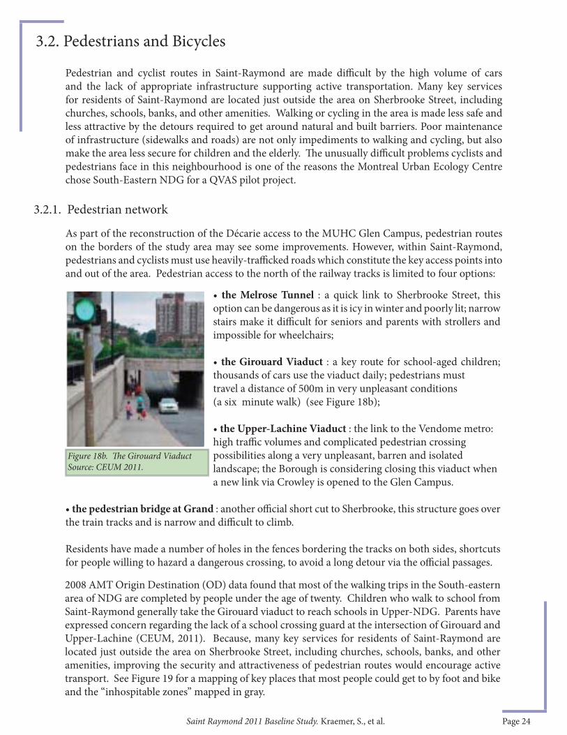
• the Melrose Tunnel : a quick link to Sherbrooke Street, this option can be dangerous as it is icy in winter and poorly lit; narrow stairs make it diffi cult for seniors and parents with strollers and impossible for wheelchairs;
• the Girouard Viaduct : a key route for school-aged children; thousands of cars use the viaduct daily; pedestrians must travel a distance of 500m in very unpleasant conditions
(a six minute walk) (see Figure 18b);
• the Upper-Lachine Viaduct : the link to the Vendome metro: high traffi c volumes and complicated pedestrian crossing possibilities along a very unpleasant, barren and isolated landscape; the Borough is considering closing this viaduct when a new link via Crowley is opened to the Glen Campus.
• the pedestrian bridge at Grand : another offi cial short cut to Sherbrooke, this structure goes over the train tracks and is narrow and diffi cult to climb.
Residents have made a number of holes in the fences bordering the tracks on both sides, shortcuts for people willing to hazard a dangerous crossing, to avoid a long detour via the offi cial passages.
Figure 18b. Th e Girouard ViaductSource: CEUM 2011.
Pedestrian and cyclist routes in Saint-Raymond are made diffi cult by the high volume of cars and the lack of appropriate infrastructure supporting active transportation. Many key services for residents of Saint-Raymond are located just outside the area on Sherbrooke Street, including churches, schools, banks, and other amenities. Walking or cycling in the area is made less safe and less attractive by the detours required to get around natural and built barriers. Poor maintenance of infrastructure (sidewalks and roads) are not only impediments to walking and cycling, but also make the area less secure for children and the elderly. Th e unusually diffi cult problems cyclists and pedestrians face in this neighbourhood is one of the reasons the Montreal Urban Ecology Centre chose South-Eastern NDG for a QVAS pilot project.
As part of the reconstruction of the Décarie access to the MUHC Glen Campus, pedestrian routes on the borders of the study area may see some improvements. However, within Saint-Raymond, pedestrians and cyclists must use heavily-traffi cked roads which constitute the key access points into and out of the area. Pedestrian access to the north of the railway tracks is limited to four options:
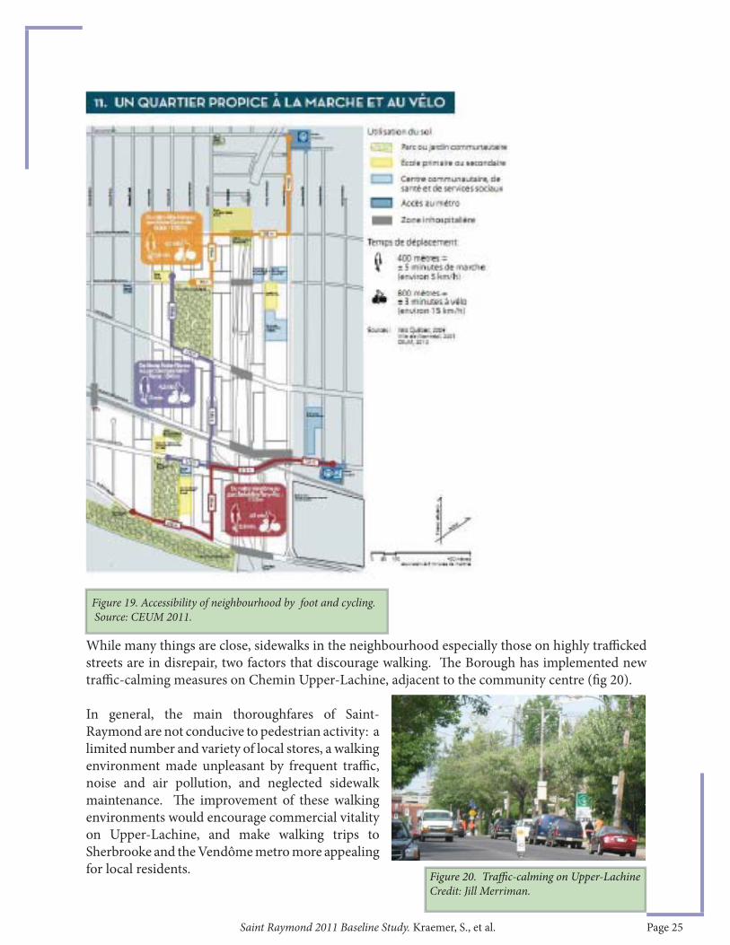
2008 AMT Origin Destination (OD) data found that most of the walking trips in the South-eastern area of NDG are completed by people under the age of twenty. Children who walk to school from Saint-Raymond generally take the Girouard viaduct to reach schools in Upper-NDG. Parents have expressed concern regarding the lack of a school crossing guard at the intersection of Girouard and Upper-Lachine (CEUM, 2011). Because, many key services for residents of Saint-Raymond are located just outside the area on Sherbrooke Street, including churches, schools, banks, and other amenities, improving the security and attractiveness of pedestrian routes would encourage active transport. See Figure 19 for a mapping of key places that most people could get to by foot and bike and the “inhospitable zones” mapped in gray.
3.2.1. Pedestrian network
3.2. Pedestrians and Bicycles
Saint Raymond 2011 Baseline Study. Kraemer, S., et al. Page 25
While many things are close, sidewalks in the neighbourhood especially those on highly traffi cked streets are in disrepair, two factors that discourage walking. Th e Borough has implemented new traffi c-calming measures on Chemin Upper-Lachine, adjacent to the community centre (fi g 20).
In general, the main thoroughfares of Saint-Raymond are not conducive to pedestrian activity: a limited number and variety of local stores, a walking environment made unpleasant by frequent traffi c, noise and air pollution, and neglected sidewalk maintenance. Th e improvement of these walking environments would encourage commercial vitality on Upper-Lachine, and make walking trips to Sherbrooke and the Vendôme metro more appealing for local residents. Figure 20. Traffi c-calming on Upper-Lachine
Credit: Jill Merriman.
Figure 19. Accessibility of neighbourhood by foot and cycling. Source: CEUM 2011.

Saint Raymond 2011 Baseline Study. Kraemer, S., et al. Page 26
Th e cycling infrastructure is insuffi cient in Saint-Raymond, although paths outside the area connect well to downtown. Montreal has two heavily used bike paths connecting Western neighbourhoods to Downtown. A heavily used commuter bike path runs along de Maisonneuve just north of Saint-Raymond, connecting NDG with the downtown core (see fi g 22 for the bike map of the area).
A crucial link in this route remains to be completed at intersection of Decarie and de Maisonneuve, just East of Saint-Raymond, as will be discussed later in this report (see sidebar 6). A second path along the Lachine Canal links the Town of Lachine to Montreal’s Old Port. Th e Lachine Canal Bike Path is used by commuters as well as thousands of recreational cyclists.
Th e 2005 Master Plan for the MUHC’s Glen Campus included links via the hospital site to the Downtown and Lachine Canal, but these are no longer in the plan. Also, the most recent City of Montreal cycling network plan does not foresee a connection to Saint-Raymond either. But Borough planners are exploring the possibility of adding a bike path on Upper-Lachine, linking de Maisonneuve and downtown. With so many large projects underway concurrently and many diff erent players (e.g. City and Borough departments, provincial ministries, private consortia), it becomes a challenge for mobilized residents with proposals for improving active transportation networks to get their voice heard. Th ese improvements have modest capital requirements, compared to those of the projects under construction, but require all players to agree that they are important and to integrate them into their planning.
Actions taken over the next months and years will play a large role in determining what long-term improvements, if any, are made to the area.
3.2.2. Cycling infrastructure
Figure 22. Cycling network, 2011. Source: Ville de Montreal.
Figure 21. Public transit counts (2010). Source: CEUM 2011.
Saint Raymond 2011 Baseline Study. Kraemer, S., et al. Page 27
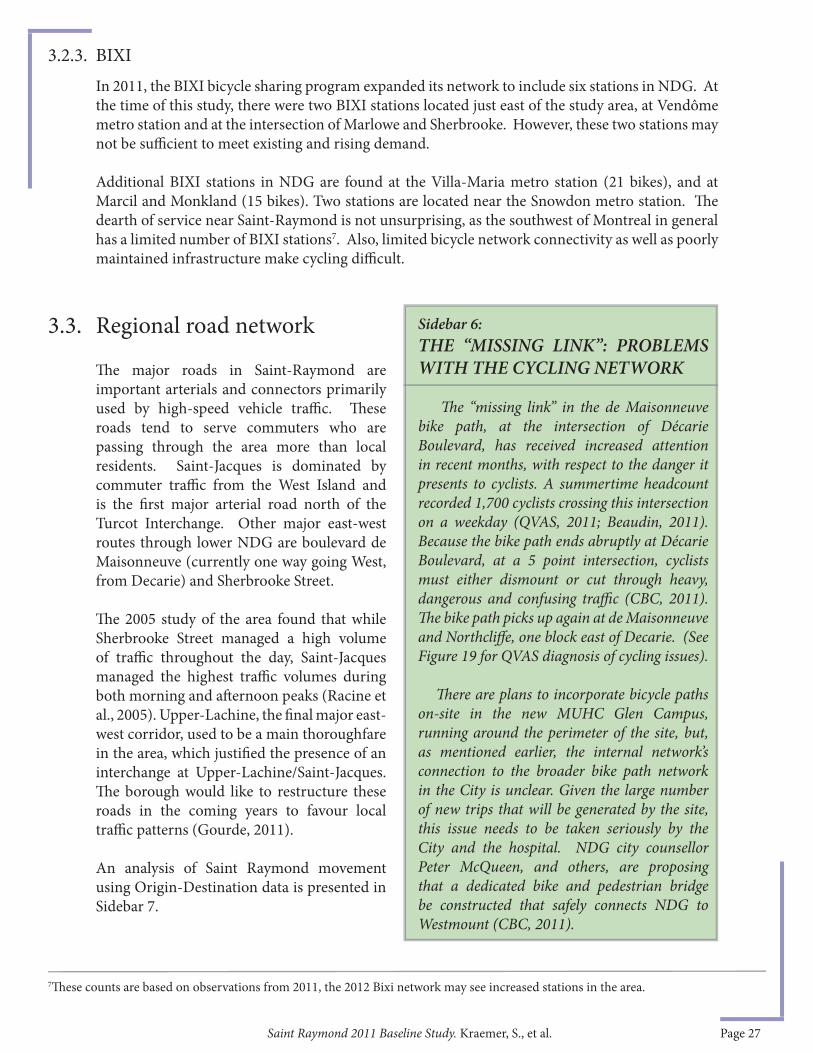
Sidebar 6:THE “MISSING LINK”: PROBLEMS WITH THE CYCLING NETWORK
Th e “missing link” in the de Maisonneuve bike path, at the intersection of Décarie Boulevard, has received increased attention in recent months, with respect to the danger it presents to cyclists. A summertime headcount recorded 1,700 cyclists crossing this intersection on a weekday (QVAS, 2011; Beaudin, 2011). Because the bike path ends abruptly at Décarie Boulevard, at a 5 point intersection, cyclists must either dismount or cut through heavy, dangerous and confusing traffi c (CBC, 2011). Th e bike path picks up again at de Maisonneuve and Northcliff e, one block east of Decarie. (See Figure 19 for QVAS diagnosis of cycling issues).
Th ere are plans to incorporate bicycle paths on-site in the new MUHC Glen Campus, running around the perimeter of the site, but, as mentioned earlier, the internal network’s connection to the broader bike path network in the City is unclear. Given the large number of new trips that will be generated by the site, this issue needs to be taken seriously by the City and the hospital. NDG city counsellor Peter McQueen, and others, are proposing that a dedicated bike and pedestrian bridge be constructed that safely connects NDG to Westmount (CBC, 2011).
3.3. Regional road network
Th e major roads in Saint-Raymond are important arterials and connectors primarily used by high-speed vehicle traffi c. Th ese roads tend to serve commuters who are passing through the area more than local residents. Saint-Jacques is dominated by commuter traffi c from the West Island and is the fi rst major arterial road north of the Turcot Interchange. Other major east-west routes through lower NDG are boulevard de Maisonneuve (currently one way going West, from Decarie) and Sherbrooke Street.
Th e 2005 study of the area found that while Sherbrooke Street managed a high volume of traffi c throughout the day, Saint-Jacques managed the highest traffi c volumes during both morning and aft ernoon peaks (Racine et al., 2005). Upper-Lachine, the fi nal major east-west corridor, used to be a main thoroughfare in the area, which justifi ed the presence of an interchange at Upper-Lachine/Saint-Jacques. Th e borough would like to restructure these roads in the coming years to favour local traffi c patterns (Gourde, 2011).
An analysis of Saint Raymond movement using Origin-Destination data is presented in Sidebar 7.
In 2011, the BIXI bicycle sharing program expanded its network to include six stations in NDG. At the time of this study, there were two BIXI stations located just east of the study area, at Vendôme metro station and at the intersection of Marlowe and Sherbrooke. However, these two stations may not be suffi cient to meet existing and rising demand.
Additional BIXI stations in NDG are found at the Villa-Maria metro station (21 bikes), and at Marcil and Monkland (15 bikes). Two stations are located near the Snowdon metro station. Th e dearth of service near Saint-Raymond is not unsurprising, as the southwest of Montreal in general has a limited number of BIXI stations7. Also, limited bicycle network connectivity as well as poorly maintained infrastructure make cycling diffi cult.
7Th ese counts are based on observations from 2011, the 2012 Bixi network may see increased stations in the area.
3.2.3. BIXI
Saint Raymond 2011 Baseline Study. Kraemer, S., et al. Page 28
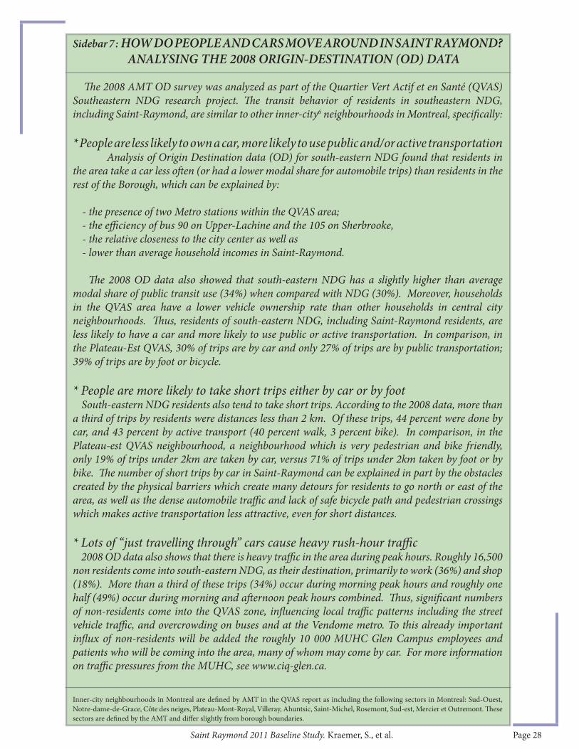
Sidebar 7 : HOW DO PEOPLE AND CARS MOVE AROUND IN SAINT RAYMOND? ANALYSING THE 2008 ORIGIN-DESTINATION (OD) DATA
Th e 2008 AMT OD survey was analyzed as part of the Quartier Vert Actif et en Santé (QVAS) Southeastern NDG research project. Th e transit behavior of residents in southeastern NDG, including Saint-Raymond, are similar to other inner-city6 neighbourhoods in Montreal, specifi cally: * People are less likely to own a car, more likely to use public and/or active transportation Analysis of Origin Destination data (OD) for south-eastern NDG found that residents in the area take a car less oft en (or had a lower modal share for automobile trips) than residents in the rest of the Borough, which can be explained by:
- the presence of two Metro stations within the QVAS area;- the effi ciency of bus 90 on Upper-Lachine and the 105 on Sherbrooke, - the relative closeness to the city center as well as - lower than average household incomes in Saint-Raymond.
Th e 2008 OD data also showed that south-eastern NDG has a slightly higher than average modal share of public transit use (34%) when compared with NDG (30%). Moreover, households in the QVAS area have a lower vehicle ownership rate than other households in central city neighbourhoods. Th us, residents of south-eastern NDG, including Saint-Raymond residents, are less likely to have a car and more likely to use public or active transportation. In comparison, in the Plateau-Est QVAS, 30% of trips are by car and only 27% of trips are by public transportation; 39% of trips are by foot or bicycle.
* People are more likely to take short trips either by car or by foot South-eastern NDG residents also tend to take short trips. According to the 2008 data, more than a third of trips by residents were distances less than 2 km. Of these trips, 44 percent were done by car, and 43 percent by active transport (40 percent walk, 3 percent bike). In comparison, in the Plateau-est QVAS neighbourhood, a neighbourhood which is very pedestrian and bike friendly, only 19% of trips under 2km are taken by car, versus 71% of trips under 2km taken by foot or by bike. Th e number of short trips by car in Saint-Raymond can be explained in part by the obstacles created by the physical barriers which create many detours for residents to go north or east of the area, as well as the dense automobile traffi c and lack of safe bicycle path and pedestrian crossings which makes active transportation less attractive, even for short distances.
* Lots of “just travelling through” cars cause heavy rush-hour traffi c 2008 OD data also shows that there is heavy traffi c in the area during peak hours. Roughly 16,500 non residents come into south-eastern NDG, as their destination, primarily to work (36%) and shop (18%). More than a third of these trips (34%) occur during morning peak hours and roughly one half (49%) occur during morning and aft ernoon peak hours combined. Th us, signifi cant numbers of non-residents come into the QVAS zone, infl uencing local traffi c patterns including the street vehicle traffi c, and overcrowding on buses and at the Vendome metro. To this already important infl ux of non-residents will be added the roughly 10 000 MUHC Glen Campus employees and patients who will be coming into the area, many of whom may come by car. For more information on traffi c pressures from the MUHC, see www.ciq-glen.ca.
Inner-city neighbourhoods in Montreal are defi ned by AMT in the QVAS report as including the following sectors in Montreal: Sud-Ouest, Notre-dame-de-Grace, Côte des neiges, Plateau-Mont-Royal, Villeray, Ahuntsic, Saint-Michel, Rosemont, Sud-est, Mercier et Outremont. Th ese sectors are defi ned by the AMT and diff er slightly from borough boundaries.
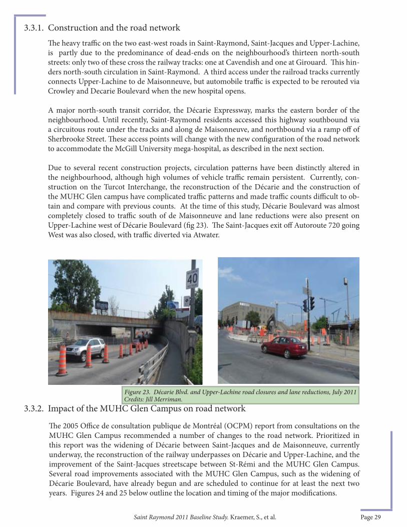
Saint Raymond 2011 Baseline Study. Kraemer, S., et al. Page 29
Th e heavy traffi c on the two east-west roads in Saint-Raymond, Saint-Jacques and Upper-Lachine, is partly due to the predominance of dead-ends on the neighbourhood’s thirteen north-south streets: only two of these cross the railway tracks: one at Cavendish and one at Girouard. Th is hin-ders north-south circulation in Saint-Raymond. A third access under the railroad tracks currently connects Upper-Lachine to de Maisonneuve, but automobile traffi c is expected to be rerouted via Crowley and Decarie Boulevard when the new hospital opens.
A major north-south transit corridor, the Décarie Expressway, marks the eastern border of the neighbourhood. Until recently, Saint-Raymond residents accessed this highway southbound via a circuitous route under the tracks and along de Maisonneuve, and northbound via a ramp off of Sherbrooke Street. Th ese access points will change with the new confi guration of the road network to accommodate the McGill University mega-hospital, as described in the next section.
Due to several recent construction projects, circulation patterns have been distinctly altered in the neighbourhood, although high volumes of vehicle traffi c remain persistent. Currently, con-struction on the Turcot Interchange, the reconstruction of the Décarie and the construction of the MUHC Glen campus have complicated traffi c patterns and made traffi c counts diffi cult to ob-tain and compare with previous counts. At the time of this study, Décarie Boulevard was almost completely closed to traffi c south of de Maisonneuve and lane reductions were also present on Upper-Lachine west of Décarie Boulevard (fi g 23). Th e Saint-Jacques exit off Autoroute 720 going West was also closed, with traffi c diverted via Atwater.
Th e 2005 Offi ce de consultation publique de Montréal (OCPM) report from consultations on the MUHC Glen Campus recommended a number of changes to the road network. Prioritized in this report was the widening of Décarie between Saint-Jacques and de Maisonneuve, currently underway, the reconstruction of the railway underpasses on Décarie and Upper-Lachine, and the improvement of the Saint-Jacques streetscape between St-Rémi and the MUHC Glen Campus. Several road improvements associated with the MUHC Glen Campus, such as the widening of Décarie Boulevard, have already begun and are scheduled to continue for at least the next two years. Figures 24 and 25 below outline the location and timing of the major modifi cations.
3.3.1. Construction and the road network
3.3.2. Impact of the MUHC Glen Campus on road network
Figure 23. Décarie Blvd. and Upper-Lachine road closures and lane reductions, July 2011 Credits: Jill Merriman.
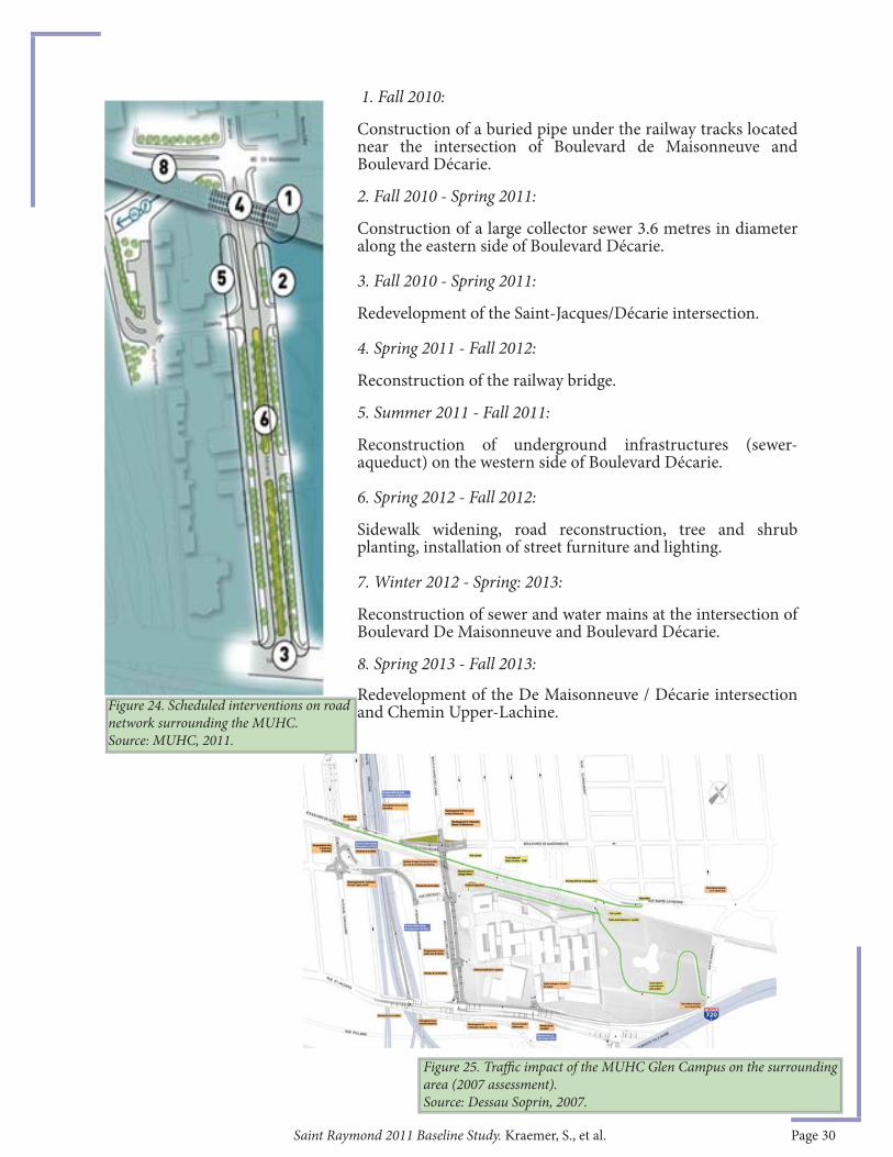
Saint Raymond 2011 Baseline Study. Kraemer, S., et al. Page 30
1. Fall 2010:
Construction of a buried pipe under the railway tracks located near the intersection of Boulevard de Maisonneuve and Boulevard Décarie.
2. Fall 2010 - Spring 2011:
Construction of a large collector sewer 3.6 metres in diameter along the eastern side of Boulevard Décarie. 3. Fall 2010 - Spring 2011:
Redevelopment of the Saint-Jacques/Décarie intersection. 4. Spring 2011 - Fall 2012:
Reconstruction of the railway bridge. 5. Summer 2011 - Fall 2011:
Reconstruction of underground infrastructures (sewer-aqueduct) on the western side of Boulevard Décarie. 6. Spring 2012 - Fall 2012:
Sidewalk widening, road reconstruction, tree and shrub planting, installation of street furniture and lighting. 7. Winter 2012 - Spring: 2013:
Reconstruction of sewer and water mains at the intersection of Boulevard De Maisonneuve and Boulevard Décarie.
8. Spring 2013 - Fall 2013:
Redevelopment of the De Maisonneuve / Décarie intersection and Chemin Upper-Lachine. Figure 24. Scheduled interventions on road
network surrounding the MUHC. Source: MUHC, 2011.
Figure 25. Traffi c impact of the MUHC Glen Campus on the surrounding area (2007 assessment).Source: Dessau Soprin, 2007.
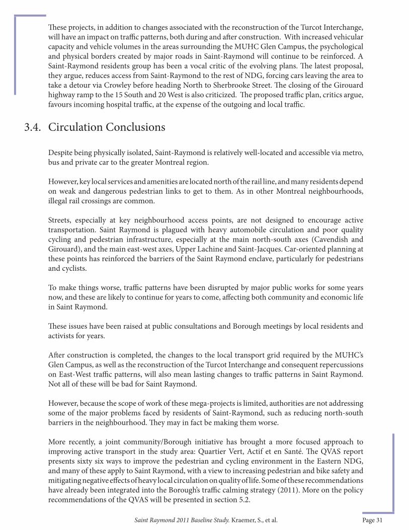
Saint Raymond 2011 Baseline Study. Kraemer, S., et al. Page 31
Th ese projects, in addition to changes associated with the reconstruction of the Turcot Interchange, will have an impact on traffi c patterns, both during and aft er construction. With increased vehicular capacity and vehicle volumes in the areas surrounding the MUHC Glen Campus, the psychological and physical borders created by major roads in Saint-Raymond will continue to be reinforced. A Saint-Raymond residents group has been a vocal critic of the evolving plans. Th e latest proposal, they argue, reduces access from Saint-Raymond to the rest of NDG, forcing cars leaving the area to take a detour via Crowley before heading North to Sherbrooke Street. Th e closing of the Girouard highway ramp to the 15 South and 20 West is also criticized. Th e proposed traffi c plan, critics argue, favours incoming hospital traffi c, at the expense of the outgoing and local traffi c.
Despite being physically isolated, Saint-Raymond is relatively well-located and accessible via metro, bus and private car to the greater Montreal region.
However, key local services and amenities are located north of the rail line, and many residents depend on weak and dangerous pedestrian links to get to them. As in other Montreal neighbourhoods, illegal rail crossings are common.
Streets, especially at key neighbourhood access points, are not designed to encourage active transportation. Saint Raymond is plagued with heavy automobile circulation and poor quality cycling and pedestrian infrastructure, especially at the main north-south axes (Cavendish and Girouard), and the main east-west axes, Upper Lachine and Saint-Jacques. Car-oriented planning at these points has reinforced the barriers of the Saint Raymond enclave, particularly for pedestrians and cyclists.
To make things worse, traffi c patterns have been disrupted by major public works for some years now, and these are likely to continue for years to come, aff ecting both community and economic life in Saint Raymond.
Th ese issues have been raised at public consultations and Borough meetings by local residents and activists for years.
Aft er construction is completed, the changes to the local transport grid required by the MUHC’s Glen Campus, as well as the reconstruction of the Turcot Interchange and consequent repercussions on East-West traffi c patterns, will also mean lasting changes to traffi c patterns in Saint Raymond. Not all of these will be bad for Saint Raymond.
However, because the scope of work of these mega-projects is limited, authorities are not addressing some of the major problems faced by residents of Saint-Raymond, such as reducing north-south barriers in the neighbourhood. Th ey may in fact be making them worse.
More recently, a joint community/Borough initiative has brought a more focused approach to improving active transport in the study area: Quartier Vert, Actif et en Santé. Th e QVAS report presents sixty six ways to improve the pedestrian and cycling environment in the Eastern NDG, and many of these apply to Saint Raymond, with a view to increasing pedestrian and bike safety and mitigating negative eff ects of heavy local circulation on quality of life. Some of these recommendations have already been integrated into the Borough’s traffi c calming strategy (2011). More on the policy recommendations of the QVAS will be presented in section 5.2.
3.4. Circulation Conclusions

Saint Raymond 2011 Baseline Study. Kraemer, S., et al. Page 32
Th is section will address economic development in the broader study area, both commercial and residential. Th e most signifi cant changes in the area regarding commercial development have taken place on Sherbrooke Street. Within Saint-Raymond, the lack of a large residential population and nuisances from existing automobile-related businesses and light industrial activity have played a role in the stalled attempts to change the commercial character of Upper-Lachine and Saint-Jacques. Th e arrival of the MUHC Glen Campus presents new opportunities for spin-off s that may greatly change areas closest to the site, although the fi nal outcome of this economic development pressure will be strongly aff ected by the reconfi guration of the road networks. Th e local community economic development corporation, in concert with the Borough, has explored options for improving Saint-Raymond since the original 2005 base line study, detailed below.
As for residential development, a number of new residential projects illustrate the eff ects of the arrival of the hospital on Saint-Raymond, although for the time being these projects have been lower-end condominium projects. Still, there is evidence of some gentrifi cation pressures being felt in the area, which will be discussed in further detail in the following sections.
Th e main economic axes of Saint-Raymond and its environs are, from south to north: Saint-Jacques Street, Chemin Upper-Lachine, de Maisonneuve Street, and Sherbrooke Street. Within the neighbourhood, Chemin Upper-Lachine off ers the most services to the residents of Saint-Raymond. However, as its off erings are limited, Saint-Raymond residents must regularly and frequently leave the neighbourhood to meet most of their basic needs and access services (Burns et al. 2010: 8). Th e commercial activity on de Maisonneuve and Sherbrooke, both located outside of the neighbourhood, provide essential services to the residents of Saint-Raymond. Sherbrooke is especially important as it is a well-known commercial zone, home to a diverse range of commercial services and business types including banks, restaurants, bakeries, dépanneurs, grocery stores and a post offi ce. Th is section will discuss the trends in commercial development along the main commercial arteries within Saint-Raymond and the surrounding areas in NDG.
Over the past decade, there has been substantial change in the character of the businesses on Sherbrooke, as locally-owned, neighbourhood-oriented stores have been replaced by high-end retail stores. Th is trend is particularly acute in Westmount, where one holding company, Cromwell Management, owns most much of the commercial space on Sherbrooke between Victoria and Claremont Street (Beitel and Lance, 2011)8 , but is also evident in commercial spaces west of Claremont to past Girouard Park.
Eff orts to organize Sherbrooke Street West businesses in NDG to form a Business Development Society (SDC) failed, aft er a breakaway group of merchants moved to decertify the group. Th e decertifi cation eff ort led to the collapse of the local Merchants Association, leaving the street vulnerable to larger commercial and retail pressures.
4. Economic Development
4.1. Main Commercial Arteries
4.1.1. Changes north of the tracks: Sherbrooke and de Maisonneuve St.
8 As of 2011, Cromwell owns much of the commercial space between Prince Albert and Grosvenor on Sherbrooke, including the entire southern portion of Sherbrooke between Prince Albert and Victoria, as well as the apartment building that houses the Hogg Quincall-erie and another building where the SAQ is located. Th ey also own a property on Westmount’s secondary commercial street, Victoria Avenue (Beitel and Lance, 2011)
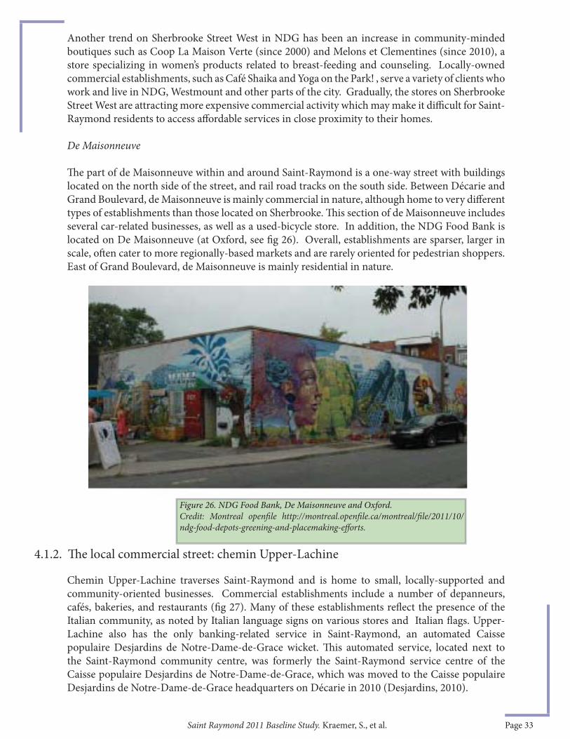
Saint Raymond 2011 Baseline Study. Kraemer, S., et al. Page 33
Another trend on Sherbrooke Street West in NDG has been an increase in community-minded boutiques such as Coop La Maison Verte (since 2000) and Melons et Clementines (since 2010), a store specializing in women’s products related to breast-feeding and counseling. Locally-owned commercial establishments, such as Café Shaika and Yoga on the Park! , serve a variety of clients who work and live in NDG, Westmount and other parts of the city. Gradually, the stores on Sherbrooke Street West are attracting more expensive commercial activity which may make it diffi cult for Saint-Raymond residents to access aff ordable services in close proximity to their homes.
De Maisonneuve
Th e part of de Maisonneuve within and around Saint-Raymond is a one-way street with buildings located on the north side of the street, and rail road tracks on the south side. Between Décarie and Grand Boulevard, de Maisonneuve is mainly commercial in nature, although home to very diff erent types of establishments than those located on Sherbrooke. Th is section of de Maisonneuve includes several car-related businesses, as well as a used-bicycle store. In addition, the NDG Food Bank is located on De Maisonneuve (at Oxford, see fi g 26). Overall, establishments are sparser, larger in scale, oft en cater to more regionally-based markets and are rarely oriented for pedestrian shoppers. East of Grand Boulevard, de Maisonneuve is mainly residential in nature.
Chemin Upper-Lachine traverses Saint-Raymond and is home to small, locally-supported and community-oriented businesses. Commercial establishments include a number of depanneurs, cafés, bakeries, and restaurants (fi g 27). Many of these establishments refl ect the presence of the Italian community, as noted by Italian language signs on various stores and Italian fl ags. Upper-Lachine also has the only banking-related service in Saint-Raymond, an automated Caisse populaire Desjardins de Notre-Dame-de-Grace wicket. Th is automated service, located next to the Saint-Raymond community centre, was formerly the Saint-Raymond service centre of the Caisse populaire Desjardins de Notre-Dame-de-Grace, which was moved to the Caisse populaire Desjardins de Notre-Dame-de-Grace headquarters on Décarie in 2010 (Desjardins, 2010).
4.1.2. Th e local commercial street: chemin Upper-Lachine
Figure 26. NDG Food Bank, De Maisonneuve and Oxford. Credit: Montreal openfi le http://montreal.openfi le.ca/montreal/fi le/2011/10/ndg-food-depots-greening-and-placemaking-eff orts.
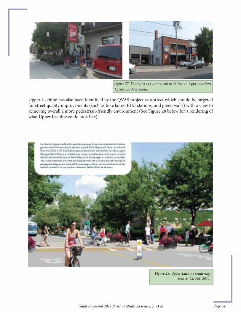
Saint Raymond 2011 Baseline Study. Kraemer, S., et al. Page 34
Upper-Lachine has also been identifi ed by the QVAS project as a street which should be targeted for street quality improvements (such as bike lanes, BIXI stations, and green walls) with a view to achieving overall a more pedestrian-friendly environment (See Figure 28 below for a rendering of what Upper Lachine could look like).
Figure 27. Examples of commercial activities on Upper-LachineCredit: Jill Merriman.
Source: CEUM, 2011.Figure 28. Upper-Lachine rendering.
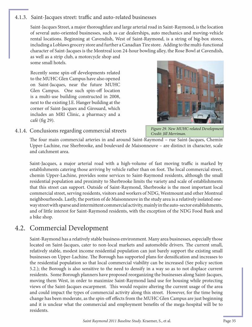
Saint Raymond 2011 Baseline Study. Kraemer, S., et al. Page 35
Saint-Jacques Street, a major thoroughfare and large arterial road in Saint-Raymond, is the location of several auto-oriented businesses, such as car dealerships, auto mechanics and moving-vehicle rental locations. Beginning at Cavendish, West of Saint-Raymond, is a string of big-box stores, including a Loblaws grocery store and further a Canadian Tire store. Adding to the multi-functional character of Saint-Jacques is the Montreal icon 24-hour bowling alley, the Rose Bowl at Cavendish, as well as a strip club, a motorcycle shop and some small hotels.
Recently some spin-off developments related to the MUHC Glen Campus have also opened on Saint-Jacques, near the future MUHC Glen Campus. One such spin-off location is a multi-use building constructed in 2008, next to the existing J.E. Hanger building at the corner of Saint-Jacques and Girouard, which includes an MRI Clinic, a pharmacy and a café (fi g 29).
Th e four main commercial arteries in and around Saint-Raymond – rue Saint-Jacques, Chemin Upper-Lachine, rue Sherbrooke, and boulevard de Maisonneuve – are distinct in character, scale and catchment area.
Saint-Jacques, a major arterial road with a high-volume of fast moving traffi c is marked by establishments catering those arriving by vehicle rather than on foot. Th e local commercial street, chemin Upper-Lachine, provides some services to Saint-Raymond residents, although the small residential population and proximity to Sherbrooke limits the variety and scale of establishments that this street can support. Outside of Saint-Raymond, Sherbrooke is the most important local commercial street, serving residents, visitors and workers of NDG, Westmount and other Montreal neighbourhoods. Lastly, the portion of de Maisonneuve in the study area is a relatively isolated one-way street with sparse and intermittent commercial activity, mainly in the auto-sector establishments, and of little interest for Saint-Raymond residents, with the exception of the NDG Food Bank and a bike shop.
Saint-Raymond has a relatively stable business environment. Many area businesses, especially those located on Saint-Jacques, cater to non-local markets and automobile drivers. Th e current small, relatively stable, modest income residential population can just barely support the existing small businesses on Upper-Lachine. Th e Borough has supported plans for densifi cation and increases to the residential population so that local commercial viability can be increased (See policy section 5.2.); the Borough is also sensitive to the need to densify in a way so as to not displace current residents. Some Borough planners have proposed reorganizing the businesses along Saint-Jacques, moving them West, in order to maximize Saint-Raymond land use for housing while protecting views of the Saint-Jacques escarpment. Th is would require altering the current usage of the area and could impact the types of commercial activity along this street. However, for the time being change has been moderate, as the spin-off eff ects from the MUHC Glen Campus are just beginning and it is unclear what the commercial and employment benefi ts of the mega-hospital will be to residents.
4.1.4. Conclusions regarding commercial streets
4.2. Commercial Development
4.1.3. Saint-Jacques street: traffi c and auto-related businesses
Figure 29. New MUHC-related Development Credit: Jill Merriman.

Saint Raymond 2011 Baseline Study. Kraemer, S., et al. Page 36
In 1999, there were fi ve-hundred and fi ft y businesses in Saint-Raymond, employing 4,622 people, where 90 percent of businesses employed less than ten employees (Studio I, 2005). Th e local community economic development corporation, the Corporation de Développement Economique Communautaire (CDEC) CDN/NDG, does not have an up to date list of businesses with which to compare these numbers. However, a Borough offi cial estimated roughly 2500 to 3000 jobs are found in businesses on Saint-Jacques between Décarie and Saint-Anne (da Sylva, July 2011). Despite the unattractiveness of having automobile-related businesses on Saint-Jacques for local residents, these industries are the source of a signifi cant number of jobs. Moreover, the current high volume of vehicular traffi c on Saint-Jacques makes the street well-suited to these types of establishments.
Given the relative stability of the auto-sector on Saint-Jacques, the borough’s focus on locally-oriented commercial development is focussed on Upper-Lachine. One way to stimulate commercial development is to increase the population density around the commercial areas. A key Borough initiative has been to encourage housing development along Upper-Lachine, in the hopes of increasing consumer demand on Upper Lachine (see section 4.3, below). Another lightweight way to improve Upper Lachine is found in a 2012 CURA report: tinyurl.com/bny7wor.
In 2005, aft er the release of the MUHC’s revised social and economic impact assessment report (Arbour 2005), the CDEC CDN-NDG initiated a stakeholder engagement process with business people, community groups and residents to explore eff orts and initiatives to encourage commercial development this part of NDG. Over a two year period, public meetings were held to stimulate discussion and solutions for improving the quality of life in Saint-Raymond, as well as identify potential entrepreneurs. Th e CDEC invested in several initiatives, generated via a participatory process, including a daycare on Upper-Lachine (CPE Les Petites Chenilles, with a 75,000$ investment), the preparation of a non-profi t housing development strategy, Habiter Saint-Raymond, headed by Groupe CDH and with the active support of the NDG Community Council, and a community catering initiative (Au Pois Chic). Eff orts to put Au Pois Chic on Upper-Lachine were explored, but this project located just north of Saint-Raymond, on Decarie Boulevard.
Since the Saint-Raymond population is too small to support a major commercial corridor, many residents must frequent commercial establishments in surrounding areas to meet their needs. For example, local residents shop at big box stores concentrated on Saint-Jacques west of Cavendish, between Saint-Raymond and Westhaven. Th ese establishments, accessible by car or bus, provide competition for smaller operations located within the neighbourhood. In this same commercial area there have been a few new developments, including a branch of Porte et Fenetre Verdun. Th e Borough reports there is still room for commercial buildings to be developed in this stretch.
Other new businesses which have opened in the area include a new car dealership owned by the Gabriel Group, which owns a number of dealerships on the Island of Montreal and many in proximity to Saint-Raymond9. A Harley Davidson/BMW dealer to the west of Cavendish at 6695 Saint Jacques adds to the high number of auto-related businesses on this street, as do the number of used car businesses located on the eastern portion of Saint-Jacques.
4.2.1. Dominance of auto-industry businesses
4.2.2. Stimulating commercial development in Saint-Raymond
4.2.3. Recent nearby commercial development
9 Gabriel Group’s establishments include: Ford-Lincoln Gabriel at 7100 Saint Jacques Street Ouest, Hyundai Prestige at 6435 Saint Jacques Street Ouest and Mazda Gabriel at 5333 Saint Jacques Street Ouest.)
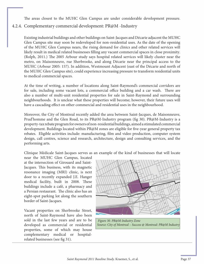
Saint Raymond 2011 Baseline Study. Kraemer, S., et al. Page 37
Th e areas closest to the MUHC Glen Campus are under considerable development pressure.
Existing industrial buildings and other buildings on Saint-Jacques and Décarie adjacent the MUHC Glen Campus site may soon be redeveloped for non-residential uses. As the date of the opening of the MUHC Glen Campus nears, the rising demand for clinics and other related services will likely result in medical related businesses fi lling any vacant commercial spaces in close proximity. (Rolph, 2011.) Th e 2005 Arbour study says hospital related services will likely cluster near the metro, on Maisonneuve, rue Sherbrooke, and along Décarie near the principal access to the MUHC (Arbour 2005: 157). In addition, Westmount Adjacent (east of the Décarie and north of the MUHC Glen Campus site), could experience increasing pressure to transform residential units to medical commercial spaces.
At the time of writing, a number of locations along Saint-Raymond’s commercial corridors are for sale, including some vacant lots, a commercial offi ce building and a car wash. Th ere are also a number of multi-unit residential properties for sale in Saint-Raymond and surrounding neighbourhoods. It is unclear what these properties will become; however, their future uses will have a cascading eff ect on other commercial and residential uses in the neighbourhood.
Moreover, the City of Montreal recently added the area between Saint-Jacques, de Maisonneuve, Prud’homme and the Glen Road, to its PR@M-Industry program (fi g 30). PR@M-Industry is a property-tax rebate program for owners of non-residential buildings, aimed a stimulated commercial development. Buildings located within PR@M zones are eligible for fi ve-year general property tax rebates. Eligible activities include: manufacturing, fi lm and video production, computer system design, call centres, science and research, architecture, design and consulting services, and the performing arts.
Clinique Médicale Saint-Jacques serves as an example of the kind of businesses that will locate near the MUHC Glen Campus, located at the intersection of Girouard and Saint-Jacques. Th is business, with its magnetic resonance imaging (MRI) clinic, is next door to a recently expanded J.E. Hanger medical facility, built in 2008. Th ese buildings include a café, a pharmacy and a Persian restaurant. Th e clinic also has an eight-spot parking lot along the southern border of Saint-Jacques.
Vacant properties on Sherbrooke Street, north of Saint-Raymond have also been sold in the last few years and are to be developed as commercial or residential properties, some of which may house complementary medical or hospital-related businesses (see fi g 31).
Figure 30. PR@M-Industry ZoneSource: City of Montreal – Success @ Montreal: PR@M Industry
4.2.4. Complementary commercial development: PR@M -Industry
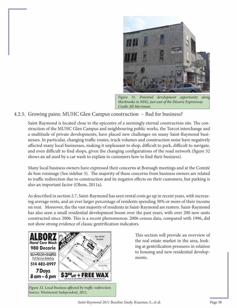
Saint Raymond 2011 Baseline Study. Kraemer, S., et al. Page 38
Figure 32. Local business aff ected by traffi c redirection. Source: Westmount Independent, 2011.
Saint-Raymond is located close to the epicentre of a seemingly eternal construction site. Th e con-struction of the MUHC Glen Campus and neighbouring public works, the Turcot interchange and a multitude of private developments, have placed new challenges on many Saint-Raymond busi-nesses. In particular, changing traffi c routes, truck volumes and construction noise have negatively aff ected many local businesses, making it unpleasant to shop, diffi cult to park, diffi cult to navigate, and even diffi cult to fi nd shops, given the changing confi gurations of the road network (fi gure 32 shows an ad used by a car wash to explain to customers how to fi nd their business).
Many local business owners have expressed their concerns at Borough meetings and at the Comité de bon voisinage (See sidebar 3). Th e majority of these concerns from business owners are related to traffi c redirection due to construction and its negative eff ects on their customers, but parking is also an important factor (Olson, 2011a).
As described in section 2.7, Saint-Raymond has seen rental costs go up in recent years, with increas-ing average rents, and an ever larger percentage of residents spending 30% or more of their income on rent. Moreover, the the vast majority of residents in Saint-Raymond are renters. Saint-Raymond has also seen a small residential development boom over the past years, with over 200 new units constructed since 2006. Th is is a recent phenomenon: 2006 census data, compared with 1996, did not show strong evidence of classic gentrifi cation indicators.
Th is section will provide an overview of the real estate market in the area, look-ing at gentrifi cation pressures in relation to housing and new residential develop-ments.
4.2.5. Growing pains: MUHC Glen Campus construction – Bad for business?
Figure 31. Potential development opportunity along Sherbrooke in NDG, just east of the Décarie ExpresswayCredit: Jill Merriman.
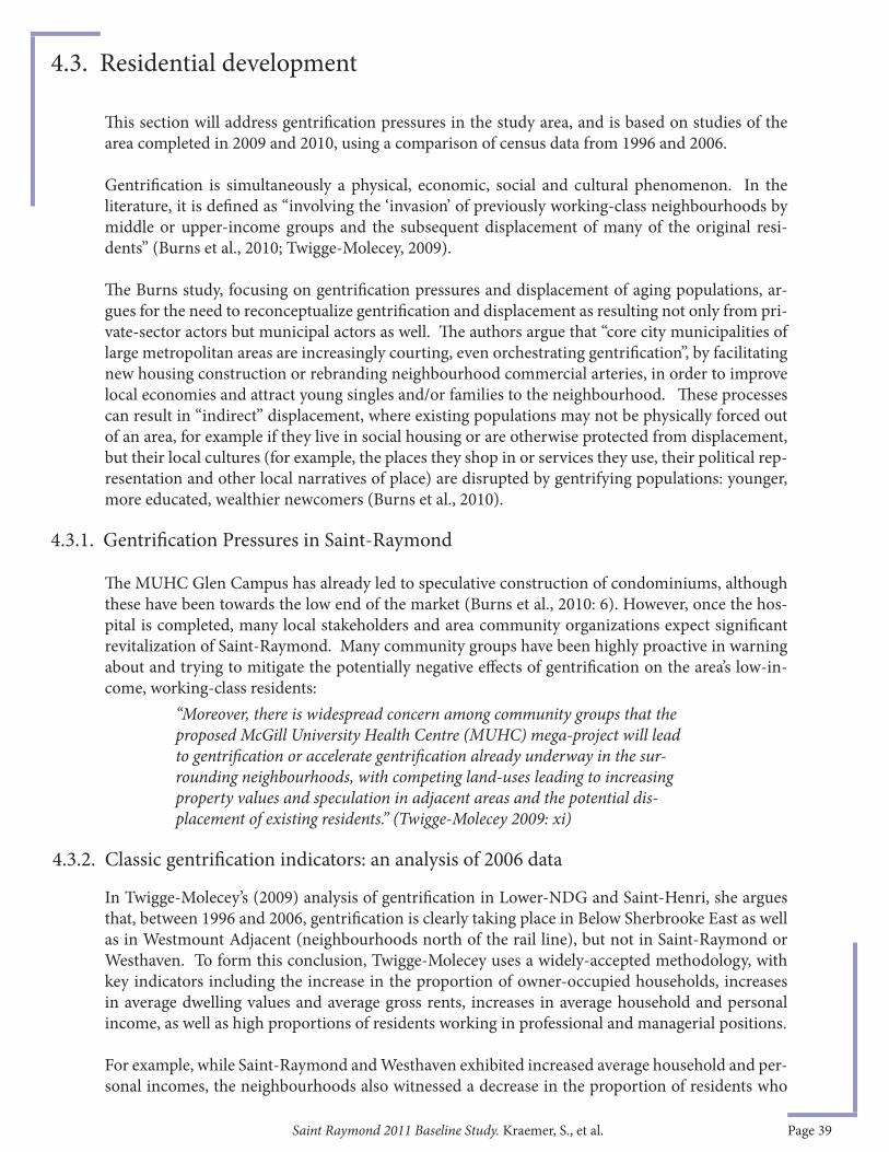
Saint Raymond 2011 Baseline Study. Kraemer, S., et al. Page 39
Th is section will address gentrifi cation pressures in the study area, and is based on studies of the area completed in 2009 and 2010, using a comparison of census data from 1996 and 2006.
Gentrifi cation is simultaneously a physical, economic, social and cultural phenomenon. In the literature, it is defi ned as “involving the ‘invasion’ of previously working-class neighbourhoods by middle or upper-income groups and the subsequent displacement of many of the original resi-dents” (Burns et al., 2010; Twigge-Molecey, 2009).
Th e Burns study, focusing on gentrifi cation pressures and displacement of aging populations, ar-gues for the need to reconceptualize gentrifi cation and displacement as resulting not only from pri-vate-sector actors but municipal actors as well. Th e authors argue that “core city municipalities of large metropolitan areas are increasingly courting, even orchestrating gentrifi cation”, by facilitating new housing construction or rebranding neighbourhood commercial arteries, in order to improve local economies and attract young singles and/or families to the neighbourhood. Th ese processes can result in “indirect” displacement, where existing populations may not be physically forced out of an area, for example if they live in social housing or are otherwise protected from displacement, but their local cultures (for example, the places they shop in or services they use, their political rep-resentation and other local narratives of place) are disrupted by gentrifying populations: younger, more educated, wealthier newcomers (Burns et al., 2010).
Th e MUHC Glen Campus has already led to speculative construction of condominiums, although these have been towards the low end of the market (Burns et al., 2010: 6). However, once the hos-pital is completed, many local stakeholders and area community organizations expect signifi cant revitalization of Saint-Raymond. Many community groups have been highly proactive in warning about and trying to mitigate the potentially negative eff ects of gentrifi cation on the area’s low-in-come, working-class residents:
In Twigge-Molecey’s (2009) analysis of gentrifi cation in Lower-NDG and Saint-Henri, she argues that, between 1996 and 2006, gentrifi cation is clearly taking place in Below Sherbrooke East as well as in Westmount Adjacent (neighbourhoods north of the rail line), but not in Saint-Raymond or Westhaven. To form this conclusion, Twigge-Molecey uses a widely-accepted methodology, with key indicators including the increase in the proportion of owner-occupied households, increases in average dwelling values and average gross rents, increases in average household and personal income, as well as high proportions of residents working in professional and managerial positions.
For example, while Saint-Raymond and Westhaven exhibited increased average household and per-sonal incomes, the neighbourhoods also witnessed a decrease in the proportion of residents who
4.3.1. Gentrifi cation Pressures in Saint-Raymond
4.3. Residential development
4.3.2. Classic gentrifi cation indicators: an analysis of 2006 data
“Moreover, there is widespread concern among community groups that the proposed McGill University Health Centre (MUHC) mega-project will lead to gentrifi cation or accelerate gentrifi cation already underway in the sur-rounding neighbourhoods, with competing land-uses leading to increasing property values and speculation in adjacent areas and the potential dis-placement of existing residents.” (Twigge-Molecey 2009: xi)

Saint Raymond 2011 Baseline Study. Kraemer, S., et al. Page 40
own, rather than rent, their dwellings (Twigge-Molecey, 2009). Typically, gentrifying neighbour-hoods see an increase in the numbers of owners. Moreover, unlike the other Lower-NDG neigh-bourhoods, Saint-Raymond and Westhaven did not see an increase in the proportion of residents working in professional and managerial positions, another indicator of gentrifi cation used in the study (Twigge-Molecey, 2009).
Other classic indicators of gentrifi cation are the proportion of university degree holders and the size of the 20-44 age group. In Saint-Raymond, Westhaven, South of Sherbrooke and Westmount Adjacent, the proportion of university degree holders has increased faster than the CMA as a whole. However, the area was not marked by a relative increase in the 20-44 age group, which demon-strates that signs of gentrifi cation were less marked than elsewhere in Montreal (Burns et al., 2010).
Still, this does not mean that the neighbourhood is exempt from gentrifi cation pressures now or in the future, it only states that as of 2006, neighbourhoods to the north of the rail line were expe-riencing gentrifi cation while Saint-Raymond was not, according to an analysis of widely accepted indicators. Th us, although 2006 census data does not indicate strong evidence of gentrifi cation up to that date, more recent data and other sources of information tell a diff erent story. Some exam-ples of new residential development occurring in the area will now be described.
4.4. Recent residential development
A number of refurbished properties converted into condominiums as well as new condominium developments have been added to the Saint-Raymond neighbourhood in the past years and have resulted in a small increase in the local population. Between 2005 and 2008, 294 units were added to Saint-Raymond (Megalas et al., 2008).
Wilson and Upper-Lachine: a failed opportunity
One of the largest of these new condominium projects is located on Wilson/Hingston and Upper-Lachine and was constructed in 2007 (fi g 33). Another, at Hingston and Upper-Lachine with 74 units, started to go up for sale in September 2011. Th is cul-de-sac development faces inward, with none of the units fronting onto Upper-Lachine. Critics have argued that this confi guration represents a potential missed opportunity to create more ground-fl oor local commercial space fronting on Upper-Lachine, to continue the streetscape and contribute to a livelier, pedestrian-friendly local street (Heff ez, 2009). Th at such a development could be given a construction permit hints at the need for better urban design controls on real estate development in the area.
Figure 33. Condo project – Upper-Lachine and Wilson (Photos: Jill Merriman, Spacing Montreal).
2009 property values of some tiny condos listed in fi gure 34 below are “aff ordable” according the City of Montreal’s guidelines.8 Th e City of Montreal lists maximum prices of private housing for fi rst time buyers in its Home Ownership Program, which targets households
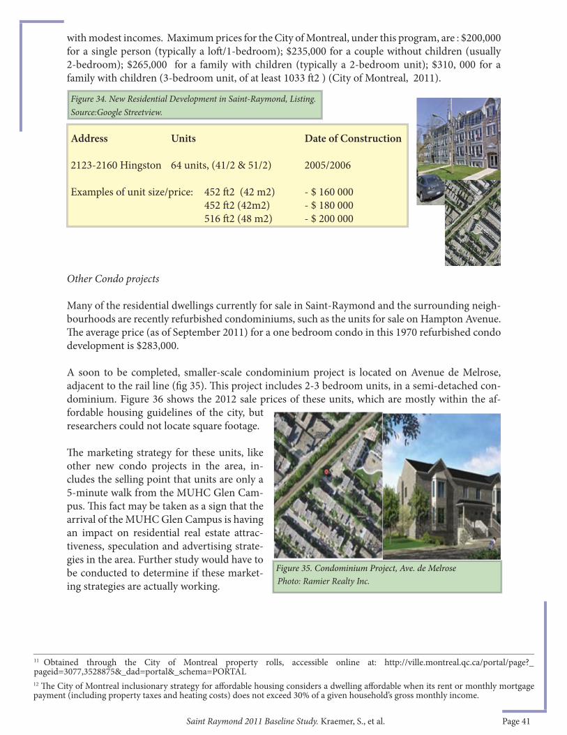
Saint Raymond 2011 Baseline Study. Kraemer, S., et al. Page 41
Figure 34. New Residential Development in Saint-Raymond, Listing. Source:Google Streetview.
Address Units Date of Construction
2123-2160 Hingston 64 units, (41/2 & 51/2) 2005/2006 Examples of unit size/price: 452 ft 2 (42 m2) - $ 160 000 452 ft 2 (42m2) - $ 180 000 516 ft 2 (48 m2) - $ 200 000
Other Condo projects
Many of the residential dwellings currently for sale in Saint-Raymond and the surrounding neigh-bourhoods are recently refurbished condominiums, such as the units for sale on Hampton Avenue. Th e average price (as of September 2011) for a one bedroom condo in this 1970 refurbished condo development is $283,000.
A soon to be completed, smaller-scale condominium project is located on Avenue de Melrose, adjacent to the rail line (fi g 35). Th is project includes 2-3 bedroom units, in a semi-detached con-dominium. Figure 36 shows the 2012 sale prices of these units, which are mostly within the af-fordable housing guidelines of the city, but researchers could not locate square footage.
Th e marketing strategy for these units, like other new condo projects in the area, in-cludes the selling point that units are only a 5-minute walk from the MUHC Glen Cam-pus. Th is fact may be taken as a sign that the arrival of the MUHC Glen Campus is having an impact on residential real estate attrac-tiveness, speculation and advertising strate-gies in the area. Further study would have to be conducted to determine if these market-ing strategies are actually working.
11 Obtained through the City of Montreal property rolls, accessible online at: http://ville.montreal.qc.ca/portal/page?_pageid=3077,3528875&_dad=portal&_schema=PORTAL12 Th e City of Montreal inclusionary strategy for aff ordable housing considers a dwelling aff ordable when its rent or monthly mortgage payment (including property taxes and heating costs) does not exceed 30% of a given household’s gross monthly income.
Figure 35. Condominium Project, Ave. de MelrosePhoto: Ramier Realty Inc.
with modest incomes. Maximum prices for the City of Montreal, under this program, are : $200,000 for a single person (typically a loft /1-bedroom); $235,000 for a couple without children (usually 2-bedroom); $265,000 for a family with children (typically a 2-bedroom unit); $310, 000 for a family with children (3-bedroom unit, of at least 1033 ft 2 ) (City of Montreal, 2011).

Saint Raymond 2011 Baseline Study. Kraemer, S., et al. Page 42
Th e Saint-Jacques/Upper-Lachine interchange is being actively considered by non-profi t housing developers as a site for future development. Th e publicly-owned intersection is currently above and below grade, however in the past few years plans have been proposed to redevelop this interchange at grade to allow for residential development on this site. According to city offi cials, an estimated 200 to 400 units of housing could be constructed on this site, depending on unit size and building heights (Megalas et al., 2008). Some elected offi cials have supported this plan, however the requal-ifi cation of the interchange is only just moving forward now, in the fall of 2012.
Th e EcoLogez 2011 Charrette, an inter-disciplinary university student brainstorming session, hosted by Equiterre and l’École de technologie supérieure (ETS) was conducted in March 2011, focussing on this site. Fift y-seven students, working in small teams, participated in the charrette and came up with a variety of visions for sustainable residential development on the site. Th e main goal was to show how to transform the interchange into a livable urban space including a park and a minimum percentage of commercial space, and housing that would appeal to MUHC Glen Cam-pus workers, the elderly, and families. Th e charrette’s “client” was Groupe CDH, a non-profi t com-munity housing developer that works closely with the NDG Community Council’s Housing Com-mittee. See Sidebar 9 for details of an eff ort to include Saint Raymond viewpoints in the charrette.
Figure 37. Design plan from the winning teams of the Ecologez Charrette, March 11-12, 2011 Designed by Keven Durand, Marilyne Primeau, Jérémy Daugreilh, Valérie Houde, Maël Camus, Axel Cohen, Pi-erre-Édouard Stephan. Amandine Lainé, Daniel Forgues (coorganisateur et professeur à l’ÉTS), Marilyn Hébert, Olivier Charbonneau-Charrette, Mélina Maiorano, Lony Tehini, Maxime Duval-S., Gabriel Lacombe, Julie Bachand-Marleau. Source: Equiterre 2011. http://equiterre.info/site/ecologez/.
4.4.1. Proposed new residential development in the area
Figure 36 Observed sale prices as of February 2012- Ave. de Melrose (3 of 5 units sold as of February 2012)
Address Description Listing price2093 Av. de Melrose Semi-detached condo - 2 Beds, 1 Baths $189,9002095 Av. de Melrose Semi-detached condo - 2 Beds, 1 Baths $235,9002097 Av. de Melrose Semi-detached condo - 3 Beds, 1 Baths $315,000
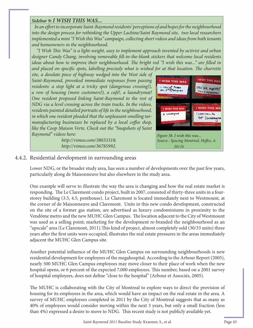
Saint Raymond 2011 Baseline Study. Kraemer, S., et al. Page 43
Lower NDG, or the broader study area, has seen a number of developments over the past few years, particularly along de Maisonneuve but also elsewhere in the study area.
One example will serve to illustrate the way the area is changing and how the real estate market is responding. Th e Le Claremont condo project, built in 2007, consisted of thirty-three units in a four-storey building (3.5, 4.5, penthouse). Le Claremont is located immediately next to Westmount, at the corner of de Maisonneuve and Claremont. Units in this new condo development, constructed on the site of a former gas station, are advertised as luxury condominiums in proximity to the Vendôme metro and the new MUHC Glen Campus. Th e location adjacent to the City of Westmount was used as a selling point; marketing for the development re-branded the neighbourhood as an “upscale” area (Le Claremont, 2011).Th is kind of project, almost completely sold (30/33 units) three years aft er the fi rst units were occupied, illustrates the real estate pressures in the areas immediately adjacent the MUHC Glen Campus site.
Another potential infl uence of the MUHC Glen Campus on surrounding neighbourhoods is new residential development for employees of the megahospital. According to the Arbour Report (2005), nearly 500 MUHC Glen Campus employees may move closer to their place of work when the new hospital opens, or 6 percent of the expected 7,000 employees. Th is number, based on a 2001 survey of hospital employees, does not defi ne “close to the hospital” (Arbour et Associés, 2005).
Th e MUHC is collaborating with the City of Montreal to explore ways to direct the provision of housing for its employees in the area, which would have an impact on the real estate in the area. A survey of MUHC employees completed in 2011 by the City of Montreal suggests that as many as 40% of employees would consider moving within the next 3 years, but only a small fraction (less than 4%) expressed a desire to move to NDG. Th is recent study is not publicly available yet.
Sidebar 9: I WISH THIS WAS... In an eff ort to incorporate Saint-Raymond residents’ perceptions of and hopes for the neighbourhood into the design process for rethinking the Upper Lachine/Saint Raymond site, two local researchers implemented a mini “I Wish this Was” campaign, collecting short videos and ideas from both tenants and homeowners in the neighbourhood. “I Wish Th is Was” is a light-weight, easy to implement approach invented by activist and urban designer Candy Chang, involving removable fi ll-in-the-blank stickers that welcome local residents ideas about how to improve their neighbourhood. Th e bright red “I wish this was...” are fi lled in and placed on specifi c spots, labelling precisely what is wished for at that location. Th e charrette site, a desolate piece of highway wedged into the West side of Saint-Raymond, provoked immediate responses from passing residents: a stop light at a tricky spot (dangerous crossing!), a row of housing (more customers!), a café!, a laundrymat! One resident proposed linking Saint-Raymond to the rest of NDG via a level crossing across the train tracks. In the videos, residents painted detailed portraits of life in the neighbourhood, in which one resident pleaded that the unpleasant-smelling tar-manufacturing businesses be replaced by a local coff ee shop, like the Coop Maison Verte. Check out the “Snapshots of Saint Raymond” videos here: http://vimeo.com/38033318; http://vimeo.com/36785992.
4.4.2. Residential development in surrounding areas
Figure 38. I wish this was...Source : Spacing Montreal, Heff ez, A. 2011b.
Saint Raymond 2011 Baseline Study. Kraemer, S., et al. Page 44
Healthcare related commercial developments are likely to occur in proximity to the MUHC Glen Campus, and are even encouraged by City incentives, such as the PR@M Industry program. Roads immediately abutting the MUHC Glen Campus, such as Decarie and deMaisonneuve, will be most directly aff ected, but complementary commercial development may also occur on Saint Jacques, Sherbrooke and along existing arteries, due to their relative proximity to the site and existing commercial character.
Analysis of classic gentrifi cation indicators from 1996 and 2006 data has shown that neighbourhoods surrounding Saint-Raymond are exhibiting signs of gentrifi cation, although Saint-Raymond and Westhaven were not, as of 2006. However, the mini-boom of new residential developments in Saint Raymond, as well as the marketing language used to sell these developments, suggests that proximity to the McGill hospital may be contributing to development pressures in these neighbourhoods. Unfortunately, with the abolition of the obligatory Census Long Form, it will be diffi cult to measure future gentrifi cation using a standardized, generally accepted methodology. Other tools will have to be developed to track neighbourhood change in areas undergoing development pressure.
Saint-Raymond has been the subject of several policies and preliminary plans, which will be explored further in this section. Despite a general consensus that the sector should be a municipal priority, little progress has been made. Th e most promising development has been the Montreal Urban Ecology Centre’s Quartier vert, actif, et en santé (QVAS) project, undertaken with the collaboration of the Borough and local residents, as described in an earlier section.
In 2006, a refl ection document was prepared for the Upper-Lachine/Saint-Jacques sector (Arrondissement Côte-des-neiges–Notre-Dame-de-Grâce, 2006). Th is refl ection document, prepared by a private consulting fi rm, outlined a vision for the area and proposed specifi c interventions. Th e document was presented to the Conseil consultatif d’urbanisme (CCU) in anticipation of an allocation of municipal resources for a Plan particulier d’urbanisme (PPU, or special planning program), a fi ne-grained planning tool used by municipalities to guide development towards a particular desired state.
4.5. Economic Development Conclusions
5. POLICY AND PROGRAMS
Plans for a PPU have been delayed until recently, when the Borough again announced its intention to restart the process. Th e project’s delay was likely due to the timing and proximity of the site to larger municipal and provincial projects including the remodeling of the Turcot Interchange and the construction of the MUHC Glen Campus, as well as for a variety of political, administrative and fi nancial reasons 13. Still, some of the ideas from the refl ection document were integrated into the revised chapter of the Borough master plan, which lists the Upper-Lachine/Saint-Jacques sector (including Saint-Raymond) as a special planning area for the Borough (refered to as a secteur de
5.1.1. Detailed refl ection document, « Secteur de planifi cation détaillée Saint-Jacques- Upper-Lachine », 2006
5.1. Borough plans
13 Specifi c planning projects require fi nancing from the City central planning division. In order to be approved, the refl ection documents must show a certain degree of detail in not only the thoroughness of the presentation of main goals and specifi c interventions but also in the design aspects (Conversation with Richard Gourde).)
Saint Raymond 2011 Baseline Study. Kraemer, S., et al. Page 45
planifi cation détaillée, see section 5.1.3 for more information). Th e designation of this area as needing special attention is due in part to its proximity to the MUHC Glen Campus site.
Th us, the proposed changes to Saint-Jacques and the future of Saint-Raymond as a whole will most likely be repositioned within the scope of a larger city-led refl ection on the area around the MUHC Glen Campus. Given its strategic proximity to two mega-projects, it is logical that the City would want an increased role in the planning of the area. However, any planning policies or tools used in the area around the Glen Campus and Saint-Raymond will likely take a minimum of 3-5 years to take eff ect. Still, given that the MUHC Glen Campus is projected to be open to the public in 2015, this planning and refl ection process may occur more quickly than a standard PPU process.
Densify Saint-Raymond
One of the key initiatives put forth in the Borough’s plan included the densifi cation of the neighborhood. Greater population would solve many problems: bolster neighbourhood commerce on Chemin Upper-Lachine, increase services such as schools and social programming. A rethinking of Saint-Jacques in favour of residential development would slow traffi c down on this street while increasing pedestrian and cyclist safety.
Th e vision upheld by the Borough plan was of Upper-Lachine Road as an important commercial artery, with an urban village feel.
To achieve this, the population of Saint-Raymond would have to almost double its size, from roughly 4000 to 8000 residents. Th e document recommended new 6-8 storey, multi-unit residential developments along Saint-Jacques and at the western end of Upper-Lachine. Studies would have to be made to assure that the land is stable enough for development, and, given current and historical land uses, much of this land may need remediation prior to residential infi ll. Th e change in land use of the area along the escarpment is also motivated by the Borough’s interest in protecting the escarpment; some critics are not persuaded that residential development along the top of the escarpment will protect the area.
Also, the goal of increasing the population of the area without removing jobs and hurting the economic development is not an easy task to accomplish. A variety of strategies are available for encouraging relocation of commercial and light industrial uses elsewhere, such as tax incentives for relocation in specifi c areas outside of core urban zones however these strategies are expensive.
5.1.2. Proposed changes
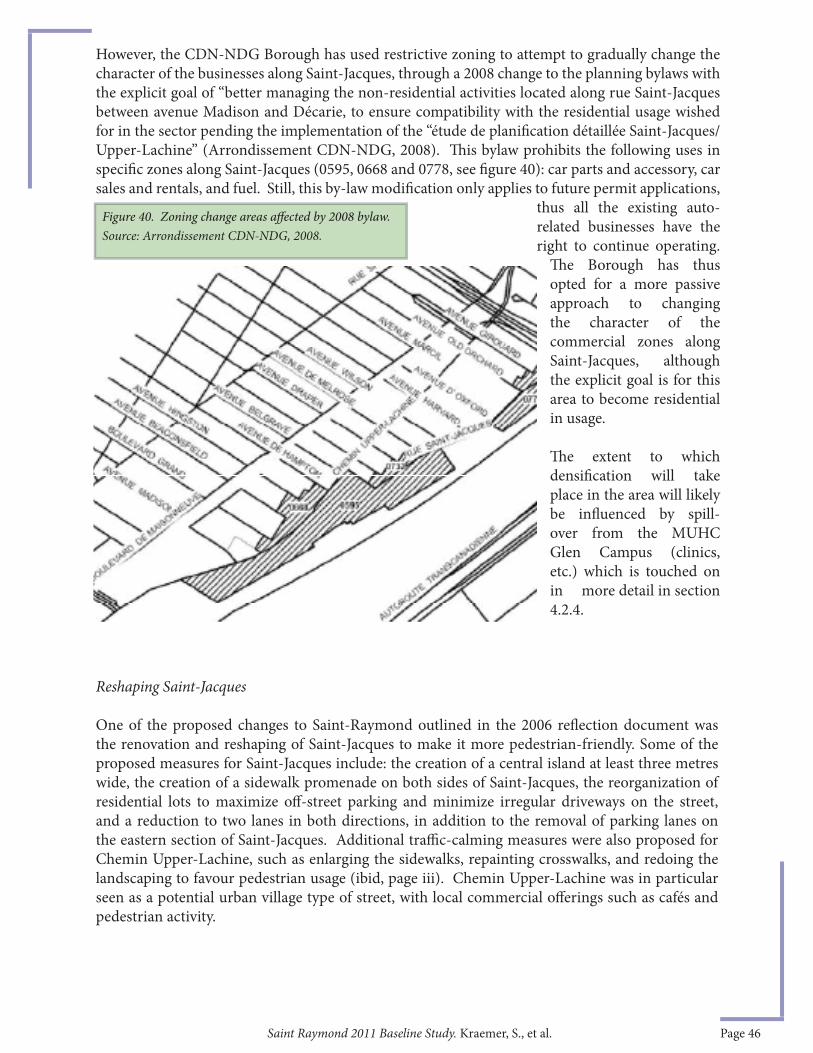
Saint Raymond 2011 Baseline Study. Kraemer, S., et al. Page 46
Reshaping Saint-Jacques
One of the proposed changes to Saint-Raymond outlined in the 2006 refl ection document was the renovation and reshaping of Saint-Jacques to make it more pedestrian-friendly. Some of the proposed measures for Saint-Jacques include: the creation of a central island at least three metres wide, the creation of a sidewalk promenade on both sides of Saint-Jacques, the reorganization of residential lots to maximize off -street parking and minimize irregular driveways on the street, and a reduction to two lanes in both directions, in addition to the removal of parking lanes on the eastern section of Saint-Jacques. Additional traffi c-calming measures were also proposed for Chemin Upper-Lachine, such as enlarging the sidewalks, repainting crosswalks, and redoing the landscaping to favour pedestrian usage (ibid, page iii). Chemin Upper-Lachine was in particular seen as a potential urban village type of street, with local commercial off erings such as cafés and pedestrian activity.
However, the CDN-NDG Borough has used restrictive zoning to attempt to gradually change the character of the businesses along Saint-Jacques, through a 2008 change to the planning bylaws with the explicit goal of “better managing the non-residential activities located along rue Saint-Jacques between avenue Madison and Décarie, to ensure compatibility with the residential usage wished for in the sector pending the implementation of the “étude de planifi cation détaillée Saint-Jacques/Upper-Lachine” (Arrondissement CDN-NDG, 2008). Th is bylaw prohibits the following uses in specifi c zones along Saint-Jacques (0595, 0668 and 0778, see fi gure 40): car parts and accessory, car sales and rentals, and fuel. Still, this by-law modifi cation only applies to future permit applications,
thus all the existing auto-related businesses have the right to continue operating.
Th e Borough has thus opted for a more passive approach to changing the character of the commercial zones along Saint-Jacques, although the explicit goal is for this area to become residential in usage.
Th e extent to which densifi cation will take place in the area will likely be infl uenced by spill-over from the MUHC Glen Campus (clinics, etc.) which is touched on in more detail in section 4.2.4.
Figure 40. Zoning change areas aff ected by 2008 bylaw. Source: Arrondissement CDN-NDG, 2008.

Saint Raymond 2011 Baseline Study. Kraemer, S., et al. Page 47
Despite the failure to enact a PPU for the sector, parts of the 2006 refl ection document was integrated into the 2009 Borough Master plan, a chapter of the City’s Master Plan. Th e NDG/CDN chapter of the plan identifi es the Upper-Lachine/Saint-Jacques sector as one of four sectors requiring a detailed local plan with specifi c goals and targets for the sector. Th e Upper-Lachine/Saint-Jacques sector is defi ned as the area between Décarie highway and the Borough of Côte-Saint-Luc–Hampstead–Montréal-Ouest, underneath the tracks, which corresponds to the neighbourhoods of Saint-Raymond and Westhaven.
Th e four main goals set out for the Upper-Lachine/Saint-Jacques sector are:- Consolidating the residential and commercial functions of the sector- Improving accessibility to the sector- Improving the general image of the sector- Preserving the Falaise Saint-Jacques and recognizing it as an “eco-territory”.
“Ecoterritories” are defi ned by the City of Montreal as “tracts of land conducive to the creation of new protected areas” in the Policy on the protection and enhancement of natural habitats (City of Montreal, 2004). Th is term refers to “areas of remarkable biodiversity” and can include already protected areas as well as natural spaces to be protected and enhanced.
Th is plan also called for the consolidation of commercial activities between Madison avenue and West Broadway, restricted expansion of industrial activities, various improvements to the connectivity between the sector and the surrounding area both for pedestrians and cyclists, an improved public domain and landscaping of Saint-Jacques in conjunction with traffi c calming measures to improve the image of the sector, ensure high quality construction on Saint-Jacques, and protect the Saint-Jacques escarpment. Aspects of the original plan that were incorporated into the Master Plan were less ambitious than those outlined in the 2006 refl ection document.
Th ere have been other Borough-level initiatives since the previous baseline study which could aff ect the future of Saint -Raymond. For example, the very recent Urban Forestry Plan, enacted in 2011, calls for supporting greening measures of both public and private space to reduce heat islands and favour the increase of urban forest biodiversity. Th is program is similar to those enacted in other Boroughs, and could improve green spaces within Saint-Raymond.
Th e Plan Vert of the Borough, enacted in 2008, puts forward a plan for 2008-2012 which among other initiatives, calls for the fi nancial support of projects to improve the environment and quality of life of residents, such as improvements to the alley networks (Ruelles vertes).
Lastly, the Plan d’action famille (2008) is a Borough-level plan which calls for a variety of actions to improve quality of life for families, including increasing security and improving circulation and transportation for residents.
Th e Quartier Vert, Actif et en Santé (sometimes referred to by its English name – Green, Active and Healthy Neighbourhoods) project in Southeastern NDG is part of a series of pilot projects
5.1.4. Other borough plans
5.2. Quartier Vert, Actif et en Santé – Southeastern NDG
5.1.3. 2009 Borough Master Plan
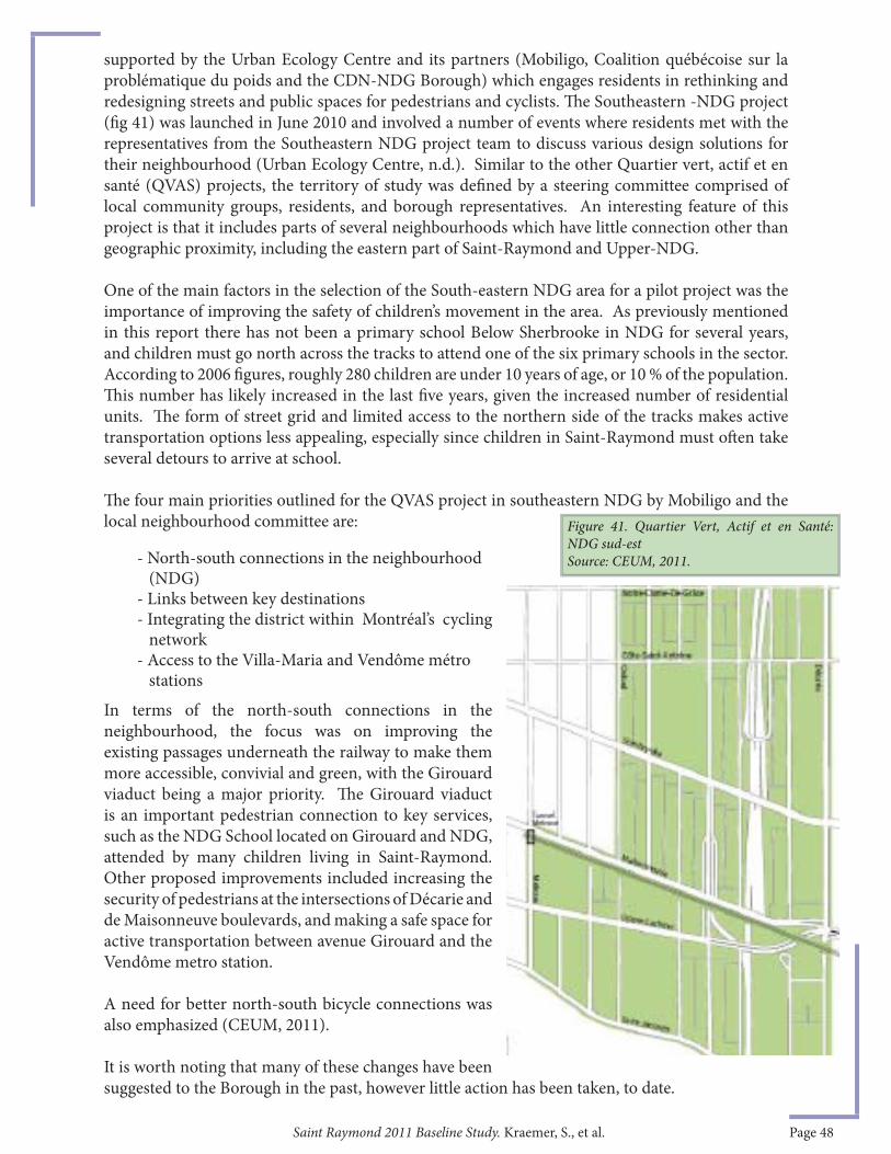
Saint Raymond 2011 Baseline Study. Kraemer, S., et al. Page 48
supported by the Urban Ecology Centre and its partners (Mobiligo, Coalition québécoise sur la problématique du poids and the CDN-NDG Borough) which engages residents in rethinking and redesigning streets and public spaces for pedestrians and cyclists. Th e Southeastern -NDG project (fi g 41) was launched in June 2010 and involved a number of events where residents met with the representatives from the Southeastern NDG project team to discuss various design solutions for their neighbourhood (Urban Ecology Centre, n.d.). Similar to the other Quartier vert, actif et en santé (QVAS) projects, the territory of study was defi ned by a steering committee comprised of local community groups, residents, and borough representatives. An interesting feature of this project is that it includes parts of several neighbourhoods which have little connection other than geographic proximity, including the eastern part of Saint-Raymond and Upper-NDG.
One of the main factors in the selection of the South-eastern NDG area for a pilot project was the importance of improving the safety of children’s movement in the area. As previously mentioned in this report there has not been a primary school Below Sherbrooke in NDG for several years, and children must go north across the tracks to attend one of the six primary schools in the sector. According to 2006 fi gures, roughly 280 children are under 10 years of age, or 10 % of the population. Th is number has likely increased in the last fi ve years, given the increased number of residential units. Th e form of street grid and limited access to the northern side of the tracks makes active transportation options less appealing, especially since children in Saint-Raymond must oft en take several detours to arrive at school.
Th e four main priorities outlined for the QVAS project in southeastern NDG by Mobiligo and the local neighbourhood committee are:
In terms of the north-south connections in the neighbourhood, the focus was on improving the existing passages underneath the railway to make them more accessible, convivial and green, with the Girouard viaduct being a major priority. Th e Girouard viaduct is an important pedestrian connection to key services, such as the NDG School located on Girouard and NDG, attended by many children living in Saint-Raymond. Other proposed improvements included increasing the security of pedestrians at the intersections of Décarie and de Maisonneuve boulevards, and making a safe space for active transportation between avenue Girouard and the Vendôme metro station.
A need for better north-south bicycle connections was also emphasized (CEUM, 2011).
It is worth noting that many of these changes have been suggested to the Borough in the past, however little action has been taken, to date.
Figure 41. Quartier Vert, Actif et en Santé: NDG sud-est Source: CEUM, 2011.- North-south connections in the neighbourhood
(NDG)- Links between key destinations- Integrating the district within Montréal’s cycling network- Access to the Villa-Maria and Vendôme métro stations
Saint Raymond 2011 Baseline Study. Kraemer, S., et al. Page 49
Aft er traffi c-calming workshops with city planning and community professionals to seek solutions to resident-identifi ed problems, the southeastern-NDG QVAS project is now at the stage of propos-ing and validating an action plan in conjunction and collaboration with the Borough. Th e action plan has been adopted as of November 2011. While the area within the borders of Sherbrooke, Saint-Jacques, Décarie and Melrose will be heavily aff ected by megaprojects such as the recon-struction of the Turcot and the completion of the MUHC Glen Campus, the Urban Ecology Centre hopes that their work will help serve as a reference for proposed changes in the area, as a represen-tation of what residents want the area to be (CEUM, 2011).
Importantly, a local Comité de suivi QVAS has been established with the active participation of the Borough, the MUHC, community groups and local residents, to oversee the implementation of the QVAS plan, over the next few years. Led by the NDG Community Council, the committee has staff support from the Council and technical support from the Urban Ecology Centre, for the fi rst year of operations.
Local plans and policies for Saint-Raymond must be set in the context of the two mega-projects currently under construction nearby, both the MUHC Glen Campus and the Turcot. Th ese large-s-cale projects present both opportunities and challenges for the residents of Saint-Raymond.
Because of its proximity to these mega-projects, representing a total public investmentexceeding $5B dollars, Saint Raymond is under close scrutiny by public, private and community interests. Public policy initiatives may be initiated at all levels of government to aff ect and shape change in the neighbourhood. Increased private sector activity is also likely to be observed in the coming years.
Th e QVAS planning approach, given that it is a joint Borough/community initiative, may prove to be a more immediate way for local residents to aff ect change and determine priorities in Saint Ray-mond, while city-centre plans and policies may have a more lasting and eff ect on the community.
5.3. Policy Summary
Saint Raymond 2011 Baseline Study. Kraemer, S., et al. Page 50
Saint-Raymond, near the epi-centre of two mega-projects, is a neighbourhood in transition.
Th e past decade has brought change to the neighbourhood. Evolving demographic patterns, such as a relative decline of the Italian community in favour of increasing rates of visible minorities, and increasing housing costs, which benefi t homeowners but increase hardship for renting families, are being felt. Important new residential projects and changes to the local transport network are underway.
Up to 2006, Saint-Raymond had not experienced the same degree of gentrifi cation pressures as neighbouring communities, partially due to its small size, the presence of high-volume streets and its poor connectivity. Since 2006, however, there has been signifi cant infi ll development; the full impact of the two nearby megaprojects on Saint-Raymond has yet to be seen.
Large-scale, regionally-focused projects such as the MUHC Glen Campus and the reconstruction of the Turcot Interchange and Decarie Expressway are aff ecting and will continue to aff ect Saint-Raymond. Temporary disruption to traffi c patterns and the temporary removal of parking spaces has negatively aff ected local businesses and residents, while future permanent increases to vehicular circulation in the area, associated with the MUHC Glen Campus, will likely also have important impacts on the community.
Barriers to active transportation, at all access points to Saint Raymond, are important and persistent; existing pedestrian and cycling routes remain dangerous and unappealing.
Plans for the densifi cation of the neighbourhood, which would improve the chances for “neighbourhood viability” (a stronger main street, more services, schools etc), have been put on hold, with much administrative attention devoted recently to the two mega-projects.
Up until publication, this low-income, low-density, underserved area has not a priority for the City or the Borough, despite a growing number of plans and initiatives for neighbourhood improvements, and an increasingly agitated local leadership, attempting to call attention to the area’s major problems.
With many plans on hold, the community sector continues to remain committed to change forthe better; however with so many obstacles, a wide diversity of actors at many levels, and a complex web of regional forces at play in the greater area around Saint-Raymond, the impact of the community-led eff orts may remain limited.
Still, while the ultimate impact of the arrival of the MUHC Glen Campus remains an area for speculation, evidence suggests that Saint-Raymond will host new kinds of economic activity oriented towards health and hospital activities. Given its close proximity to the hospital, Saint-Raymond could also host the fi rst units of work-force housing bringing a greater population density to the neighbourhood—but strong eff orts would also have to be made to protect the existing tenants and overall neighbourhood aff ordability from the pressures of gentrifi cation.
On the other hand, perhaps change will be slower than expected, and Saint-Raymond will continue along as it has for the last 40 years, a little-known corner of NDG, a pocket of aff ordability in the ever-changing tapestry of Montreal.
6. CONCLUSION
Saint Raymond 2011 Baseline Study. Kraemer, S., et al. Page 51
Action Communiterre. 2011. “About Us”. Accessed at http://www.actioncommuniterre.qc.ca, on September 14, 2011.
Akins, F., Baez, A., Paquin, G. Ritche, J. 2005. “St. Raymond: From Farms to Freeways A historical Analysis of St. Raymond” McGill University School of Urban Planning – URBP 622 Project Planning 1 Report.
Arrondissement Côte-des-Neiges–Notre-Dame-de-Grâce. 2006. « Secteur de planifi cation détaillée Saint-Jacques–Upper-Lachine », Montréal, octobre 2006, 41 p.
Arrondissement Côte-des-Neiges–Notre-Dame-de-Grâce. 2008. Avis public aux personnes intéressées ayant de droit de signer une demande de participation à un référendum pour le second projet de règlement RCA08 17146. Accessed at http://applicatif.ville.montreal.qc.ca/som-fr/pdf_avis/pdfav6784.pdf, on January 12, 2012.
Arrondissement Côte-des-Neiges–Notre-Dame-de-Grâce, 2012. « 01-276 RÈGLEMENT D’URBANISME DE L’ARRONDISSEMENT DE CÔTE-DES-NEIGES—NOTRE-DAME-DE-GRÂCE (CODIFICATION ADMINISTRATIVE). » http://www11.ville.montreal.qc.ca/docssherlock/41947/regUrba2012.pdf
Beaudin, M., 2011. “Critical mass bike ride in NDG for new crossing at Décarie/de Maisonneuve intersection” Montreal Gazette. Retrieved July 2, 2011 from http://blogs.montrealgazette.com/2011/06/27/critical-mass-bike-ride-in-ndg-for-new-crossing-at-Décariede-maisonneuve-intersection/
Beitel, David; Lance, Jill, Bornstein, Lisa (2011). “Westmount Baseline Study 2010”. Research Report Series. RR11-01E. Montréal: CURA Making Megaprojects Work for Communities - Mégaprojets au service des communautés. Accessed online at http://www.mcgill.ca/urbanplanning/sites/mcgill.ca.urbanplanning/fi les/beitellancewmtbaselinerr11-01efi nale.pdf
Burns, Victoria, Jean-Pierre Lavoie and Damaris Rose. 2012. “Revisiting the Role of Neighbourhood Change in Social Exclusion and Inclusion of Older People ”, Journal of Aging Research 2012 : 12 pps.
CBC. 2011. “NDG cyclists want dangerous intersection changed”. Published June 27, 2011.Accessed at http://www.cbc.ca/news/canada/montreal/story/2011/06/27/cyclists-ndg-intersection.html, on July 21, 2011.
Canadian Mortgage and Housing Corporation (CMHC). 2010. Rental Market Report: Montreal CMA.
CDEC CDN/NDG. 2009. Plan d’action local pour l’économie et l’emploi (PALEE) pour CDN/NDG 2009-2012. Accessed online at http://www.cdeccdnndg.org/images/stories/documents/rapports/PALEE_2009-2012.pdf , on June 18, 2011.
7. REFERENCES
Saint Raymond 2011 Baseline Study. Kraemer, S., et al. Page 52
City of Montreal. 2006. “Strategy for the inclusion of aff ordable housing in new residential projects.” Accessed online at: http://servicesenligne2.ville.montreal.qc.ca/sel/publications/PorteAccesTelechargement?lng=Fr&systemName=7757558&client=Serv_corp.
CSDM Annexe St-Raymond. « Les locaux du centre St-Raymond sur Oxford sont fermés.” Accessed at http://www2.csdm.qc.ca/Saint-Paul/Saint-Paul-AnnStRaymond/PagePrincipale.asp, on January 18, 2012.
CSSS Cavendish. 2010. PLAN D’ACTION LOCAL DE SANTÉ PUBLIQUE 2010 – 2015.
Khun, Kosal, Carl Drouin, Christiane Montpetit. 2008. Regard sur la défavorisation à Montréal, CSSS Cavendish. Série 1, 608. Montreal, QC : Direction de santé publique, Agence de la santé et des services sociaux de Montréal. 12pgs. http://publications.santemontreal.qc.ca/uploads/tx_asssmpublications/978-2-89494-650-3.pdf
Centre d’écologie urbaine de Montréal (CEUM). 2011. Plan du Quartier vert actif et en santé de NDG Sud-Est. Montréal, QC. pp.36.
Daniel Arbour et Associés. 2005. “Centre Universitaire de Santé McGill, Contexte Économique et Impacts Socio-economiques”, Rapport, pp.159. Accessible at :http://assets.muhc.ca/redesign/docs/084Contexte_economique_impacts_socio_economiques_fev.pdf.
DESSAU-SOPRIN. 2007. CUSM – CAMPUS GLEN, Mise à jour des études d’impact sur la circulation , Rapport d’étude . PP.180.
Desjardins Caisse populaire de Notre-dame-de-Grace. Published January 7, 2010. « NOU-VELLE OFFRE DE SERVICE, Concentration de I’expertise-conseil au Siege social, boulevard Decarie ». Accessed at http://www.desjardins.com/fr/votre_caisse/81530226/communique.pdf, on December 10, 2011.
Equiterre. 2011. http://equiterre.info/site/ecologez/ Ecologez.
Famille et Aines Quebec, n.d. “Childcare centres, day care centres and home childcare” Accessed at h t t p : / / m f a . k o r e m . c o m / m f a . S e a r c h B y R e g i o n .do;jsessionid=72DF2CB260D358A32F7DAF6E012760E0 on July 23, 2011.
Heff ez, Alanah. 2011a. “ ‘I wish this was’ in St-Raymond”. Spacing Montreal, published June 19 2011. Accessed at http://spacingmontreal.ca/2011/06/19/i-wish-this-was-in-st-raymond/ on November 14, 2011.
Heff ez, Alanah. 2009. “Street Interrupted”. Spacing Montreal, published on February 19, 2009. Accessed at http://spacingmontreal.ca/2009/02/19/street-interrupted/ on October 10 2011.
Le Claremont. “Th e Project”. Accessed at http://www.leclaremont.com/index_eng.html on November 12, 2011.
Megelas, A., Delrieu, J. 2008. Habiter Saint-Raymond: fi nal report. Working document.

Saint Raymond 2011 Baseline Study. Kraemer, S., et al. Page 53
McGill University Health Centre (MUHC). 2011. “Road Work at the Glen Campus”. Retrieved July 23 from http://muhc.ca/new-muhc/page/road-work-glen-campus
Montreal Anglican. 2009. “St. Saviour’s Church winds up aft er 81 years in N.D.G.” June 2009, p. 16. Accessed at http://www.montreal.anglican.ca/pdfs/ma/MA090601.pdf on July 10 2011.
NDG Food Depot, n.d. “Since 1986 25 years in the community”. Accessed online at http://depotndg.org/en/ on October 14 2011.
Olson, I. 2011a. “Businesses near MUHC struggle to stay afl oat”. Free Press – May 24, 2011. Retrieved July 23 from http://www.freepresspaper.com/pdf/NDG_FP_May-24-2011.pdf
Olson, I. 2011b. “Groups aim for betting housing in the borough”. Free Press – October 25, 2011. Accessed at http://www.ndgfreepress.com/pdf/FP-Oct-25-2011.pdf on November 28, 2011.
Racine, N., Rossi, G., Valladares, A. 2005. “Movement in Saint-Raymond,” McGill University School of Urban Planning – URBP 622 Project Planning 1 Report.
Rolph, M; Shearmur R. 2011: Major hospitals and their impact on surrounding neighbourhoods: an exploratory study of Montreal. Accessed online at http://www.mcgill.ca/urbanplanning/sites/mcgill.ca.urbanplanning/fi les/CURA_2011_Highlights_Rolph_et_al.pdf
Statistics Canada. 2001. Census of Canada, 2001. Statistics Canada (producer). Using Census Analyser of the University of Toronto (distributor). http://dc1.chass.utoronto.ca/census/index.html (accessed July 28, 2011). All computations, use and interpretation of these data are entirely those of the authors.
Statistics Canada. 2006. Census of Canada, 2006. Statistics Canada (producer). Using Census Analyser of the University of Toronto (distributor). http://dc1.chass.utoronto.ca/census/index.html (accessed July 28, 2011). All computations, use and interpretation of these data are entirely those of the authors.
Twigge-Molecey, A. 2009. “Is gentrifi cation taking place in the neighbourhoods surrounding the MUHC? A census-based analysis of relevant indicators, 1996 & 2006”, Analysis Report RR09-02E. Montréal: CURA Making Megaprojects Work for Communities - Mégaprojets au service des communautés.
Urban Ecology Centre http://www.urbanecology.net/green-ndg
Ville de Montreal. n.d. « Success @ Montreal: PR@M Industry ». Accédé le 10 septembre 2011 au http://ville.montreal.qc.ca/portal/page?_pageid=6438,53833652&_dad=portal&_schema=PORTAL.
Ville de Montréal. 2009. Plan d’urbanisme de Montréal, Partie II : Arrondissement de Côte-des-Neiges–Notre-Dame-de-Grâce, Septembre 2009. http://ville.montreal.qc.ca/pls/portal/docs/page/plan_urbanisme_fr/media/documents/090921_chapitre_04.pdf
Ville de Montréal. 2011a. Comité du Bon Voisinage sur le Campus Glen du CUSM : construction et travaux routiers, compte rendu de la réunion tenue le mardi 22 février 2011. http://ville.montreal.qc.ca/pls/portal/docs/PAGE/M_CHANTIER_FR/MEDIA/DOCUMENTS/2011-02-22_COMPTE-RENDU_FR_0.PDF

Saint Raymond 2011 Baseline Study. Kraemer, S., et al. Page 54
Ville de Montréal. 2011b. Montréal en statistiques : Population Totale. Accessed online at http://vi l le.montreal .qc.ca/portal/page?_pageid=6897,67887840&_dad=portal&_schema=PORTAL on February 20 2012.
Westmount Independent. 2011. March 1-2, 2011 issue, vol 5 number 3a. Accessed at http://www.westmountindependent.com/WIv5.3.a.pdf, on July 2011.
Personal Communication
Conversation with Richard Gourde. July 12, 2011.
Conversation with Francois da Sylva. July 18, 2011.
Conversation with Peter McQueen, August 10, 2011.