
Open Source based GIS devlopment cases by Gaia3D_20150417
34
BJ Jang – Open Source GIS Technical Manager 17 April 2015
Transcript of Open Source based GIS devlopment cases by Gaia3D_20150417

BJ Jang – Open Source GIS Technical Manager
17 April 2015

What is Open Source GIS?01
Approach to Open Source GIS02
Case Studies in South Korea03

What is Open Source GIS?
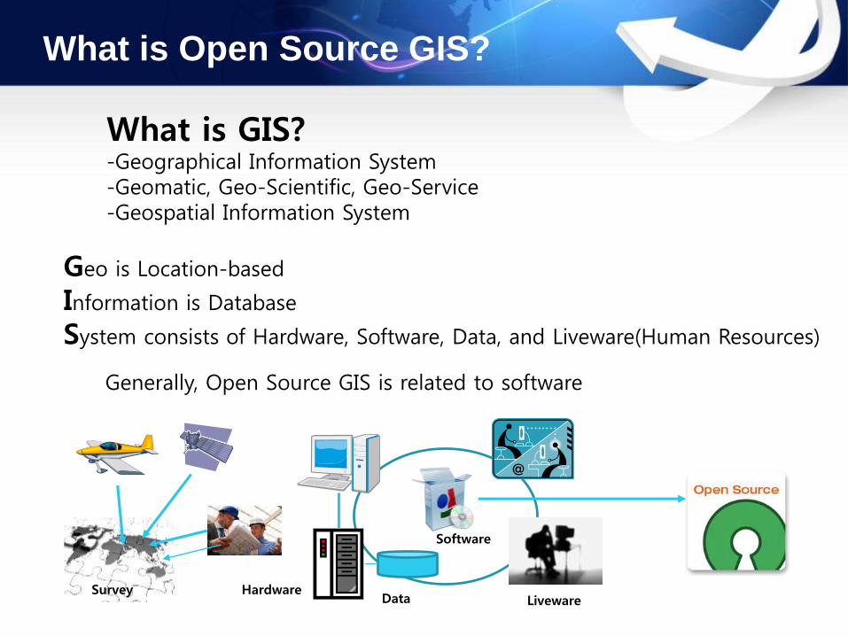
What is GIS?-Geographical Information System-Geomatic, Geo-Scientific, Geo-Service-Geospatial Information System
Geo is Location-based
Information is Database
System consists of Hardware, Software, Data, and Liveware(Human Resources)
Generally, Open Source GIS is related to software
Software
DataHardware
LivewareSurvey

What is Open Source GIS?
Open Source GIS contains- Open Source GIS Software Program (PostGIS, GeoServer, QGIS, Openlayers)- Open Data (Open Street Map)- Open License Policy(GPL, LGPL)- OGC Standards- OSGEO community
What is Open Source GIS?
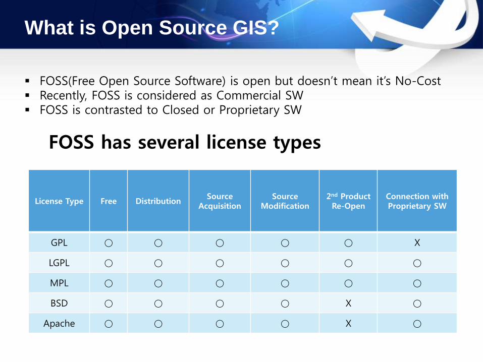
FOSS(Free Open Source Software) is open but doesn’t mean it’s No-Cost Recently, FOSS is considered as Commercial SW FOSS is contrasted to Closed or Proprietary SW
License Type Free DistributionSource
AcquisitionSource
Modification2nd Product Re-Open
Connection with Proprietary SW
GPL ○ ○ ○ ○ ○ Ⅹ
LGPL ○ ○ ○ ○ ○ ○
MPL ○ ○ ○ ○ ○ ○
BSD ○ ○ ○ ○ Ⅹ ○
Apache ○ ○ ○ ○ Ⅹ ○
FOSS has several license types
What is Open Source GIS?
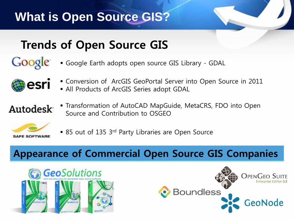
Trends of Open Source GIS
Google Earth adopts open source GIS Library - GDAL
Conversion of ArcGIS GeoPortal Server into Open Source in 2011 All Products of ArcGIS Series adopt GDAL
Transformation of AutoCAD MapGuide, MetaCRS, FDO into Open Source and Contribution to OSGEO
85 out of 135 3rd Party Libraries are Open Source
Appearance of Commercial Open Source GIS Companies

What is Open Source GIS?
OSGeo Community
OSGeo - Open Source Geospatial Foundation
• Established in Feb 4th 2006 in Chicago, USA
• Goal: to support Open Source GIS SW and promote to be used in many fields
• Non-Commercial Non-Government Organization
• Community for FOSS4G Community


Approach to Open Source GIS
Methodology of Building GIS
1.Usage of Closed S/W2.Usage of Open Source S/W3.Hybrid Usage of Closed and Open Source
ClosedOpen
In-HouseCollaborative
Leverage own knowledgeLeverage others’ knowledge too

Approach to Open Source GIS
Consideration I : Resources(Budget, Technique, SLA), Government Policy

Approach to Open Source GIS
Consideration II : Possible to substitute by Open Source? YES
ArcReader
ArcMap/ArcGIS
ArcINFO/ArcGRID
ArcPad
ArcSDE
ArcIMS
ArcGIS Server
VB, Python
uDig, GRASS, gvSIG, QGIS, OSSIM
uDig, GRASS, gvSIG, QGIS, OSSIM
GRASS, OSSIM, SEXTANTE
gvSIG mobile
PostGIS
Mapserver, GeoServer
GRASS, SEXTANTE
PHP, Python, Perl, C#.net, etc…
Viewing
Cartography
Analysis
Devices
Database
Web
Spatial Server
Scripting
3D AppGoogle Earth, MS Virtual Earth
Vworld 3D
World Wind Java, deegree iGeo3D
Earth3D, S-GeMS, Open 3D GIS

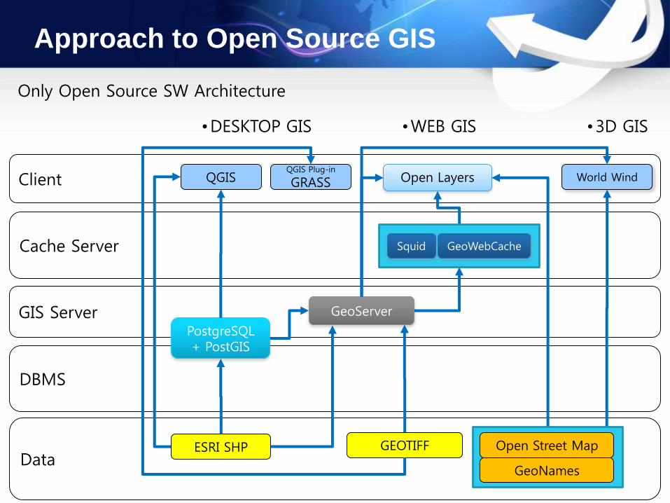
Approach to Open Source GIS
Data
DBMS
GIS Server
Cache Server
Client
ArcSDE ArcIMS
ArcMap Flash plug-in Google EarthER-Mapper
ESRI SHP GEOTIFF
•DESKTOP GIS •WEB GIS •3D GIS
ArcTMS
Google Map
Only Closed SW Architecture (ESRI & Google etc)
Oracle
Approach to Open Source GIS
Data
DBMS
GIS Server
Cache Server
Client
PostgreSQL+ PostGIS
GeoServer
QGIS Open Layers World WindQGIS Plug-in
GRASS
ESRI SHP GEOTIFF
•DESKTOP GIS •WEB GIS •3D GIS
Squid GeoWebCache
Open Street Map
GeoNames
Only Open Source SW Architecture
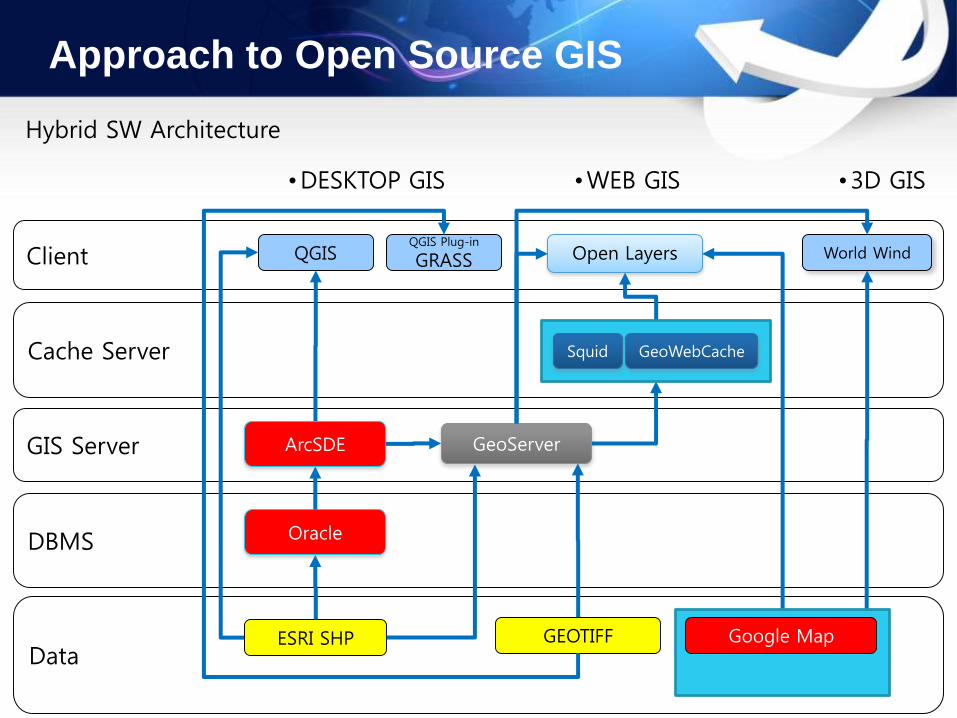
Approach to Open Source GIS
Data
DBMS
GIS Server
Cache Server
Client
ArcSDE GeoServer
QGIS Open Layers World WindQGIS Plug-in
GRASS
ESRI SHP GEOTIFF
•DESKTOP GIS •WEB GIS •3D GIS
Squid GeoWebCache
Google Map
Hybrid SW Architecture
Oracle
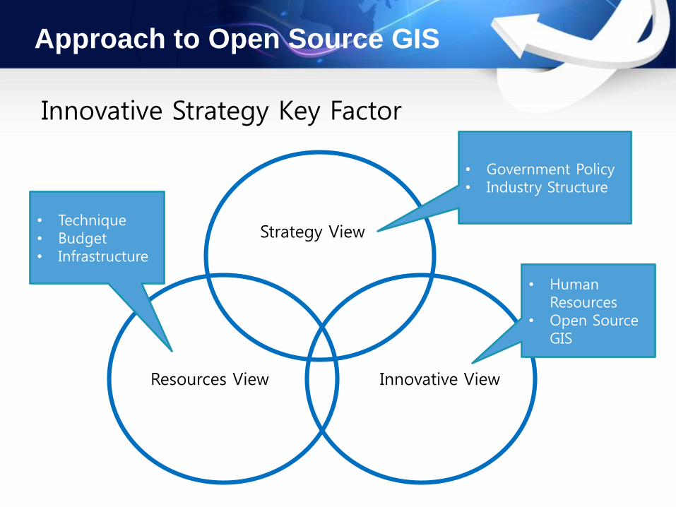
Approach to Open Source GIS
Innovative Strategy Key Factor
Resources View
Strategy View
Innovative View
• Government Policy• Industry Structure
• Human Resources
• Open Source GIS
• Technique• Budget• Infrastructure

Approach to Open Source GIS
Activities in South Korea: NIPA Open S/W Portal
OSS Portal- Open Source Software Portal
• OSS Portal is operated by NIPA(National IT Industry Promotion Agency)
• ROLE- Verification of OSS License- Consulting OSS use- Supporting OSS Community- OSS Tests- Providing OSS Technet- Servicing OSS Korean Language Translation
- Supporting OSS Project of Korean Government Fund

Approach to Open Source GIS
Activities in South Korea: Ministry of Land Infrastructure and Transport
• Open Source GIS Verification and Service
• Core Technique & Solution
• Innovative Technique
• Spatial Cloud Service
ISP: Open Source GIS R&D Road Map5 Years (2014~2018) , 1500 Million $
World
R&DInst.
Firms
NGIS R&D Infrastructure
Open Source Thinking(Open/Share/Participation)
Select & FocusGovnt
Outside-In Inside-Out
NGIS R&D Activities

Approach to Open Source GIS
Activities in South Korea: OSGEO Korea
2013 FOSS4G in Nottingham UK
FOSS4G Korea since 2011
OSGEO Korean Language Chapter Home Page


Case Studies: Geospatial Image Service
NGII(National Geographic Information Institute): Flash Client, GeoServer, Gaia3D MIP
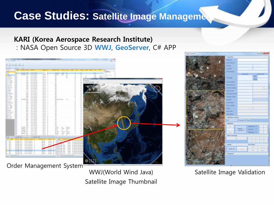
Case Studies: Satellite Image Management
KARI (Korea Aerospace Research Institute): NASA Open Source 3D WWJ, GeoServer, C# APP
Order Management SystemWWJ(World Wind Java)
Satellite Image Thumbnail
Satellite Image Validation
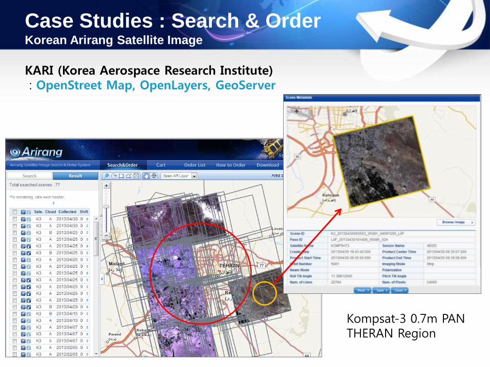
Case Studies : Search & OrderKorean Arirang Satellite Image
KARI (Korea Aerospace Research Institute): OpenStreet Map, OpenLayers, GeoServer
Kompsat-3 0.7m PANTHERAN Region
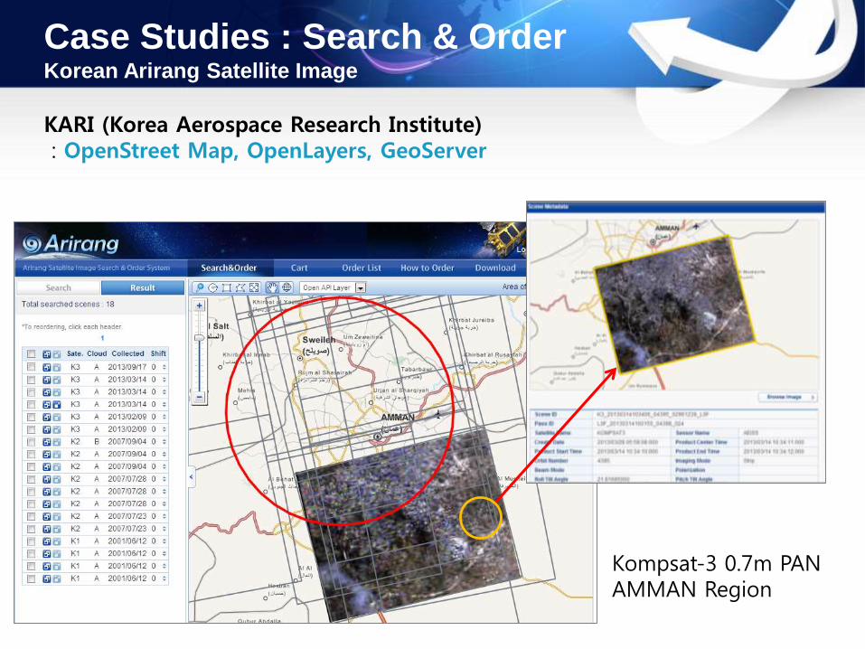
Case Studies : Search & OrderKorean Arirang Satellite Image
KARI (Korea Aerospace Research Institute): OpenStreet Map, OpenLayers, GeoServer
Kompsat-3 0.7m PANAMMAN Region

Case Studies: Global Hazard Map
SAMSUNG Global Assurance Service ( Proposed in 2012): Open Weather Data, OpenStreet OpenAPI, WWJ
Statistics AnalysisWMO / Natural Disaster Mapping with 2D/3D
Disaster Grade 2D, 3D Hazard Map
import to Database
Grid Mapping
Global Disaster Database
Cyclone
Volcano
Earthquake
World Weather Observation
Interpolated Grid
Mapping
Mapping
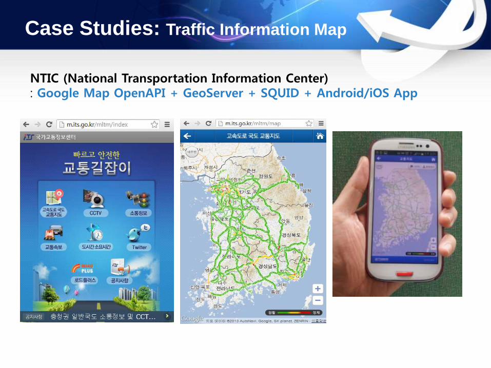
Case Studies: Traffic Information Map
NTIC (National Transportation Information Center): Google Map OpenAPI + GeoServer + SQUID + Android/iOS App
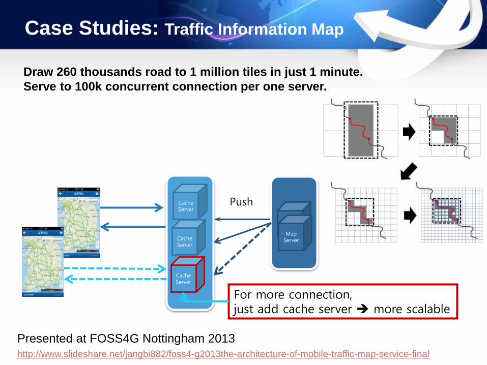
Case Studies: Traffic Information Map
Draw 260 thousands road to 1 million tiles in just 1 minute.
Serve to 100k concurrent connection per one server.
PushCacheServer
MapServer
CacheServer
CacheServer
For more connection, just add cache server more scalable
MapServer
http://www.slideshare.net/jangbi882/foss4-g2013the-architecture-of-mobile-traffic-map-service-final
Presented at FOSS4G Nottingham 2013

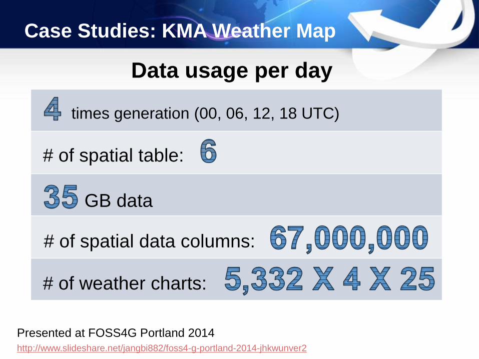
Case Studies: KMA Weather Map
KMA (Korea Meteorological Administration): PostGIS + GeoServer + Squid + OpenLayers Mobile
http://www.slideshare.net/jangbi882/foss4-g-portland-2014-jhkwunver2
Presented at FOSS4G Portland 2014
Case Studies: KMA Weather Map
times generation (00, 06, 12, 18 UTC)
# of spatial table:
# of weather charts:
GB data
# of spatial data columns:
Data usage per day

Case Studies: Tadpole SDM
http://www.slideshare.net/jangbi882/foss4g-asia-2014
Presented at FOSS4G-Asia Bangkok 2014
Web-based Spatial DB Manager for multi-DBMS: Tadpole DB Hub + Leaflet

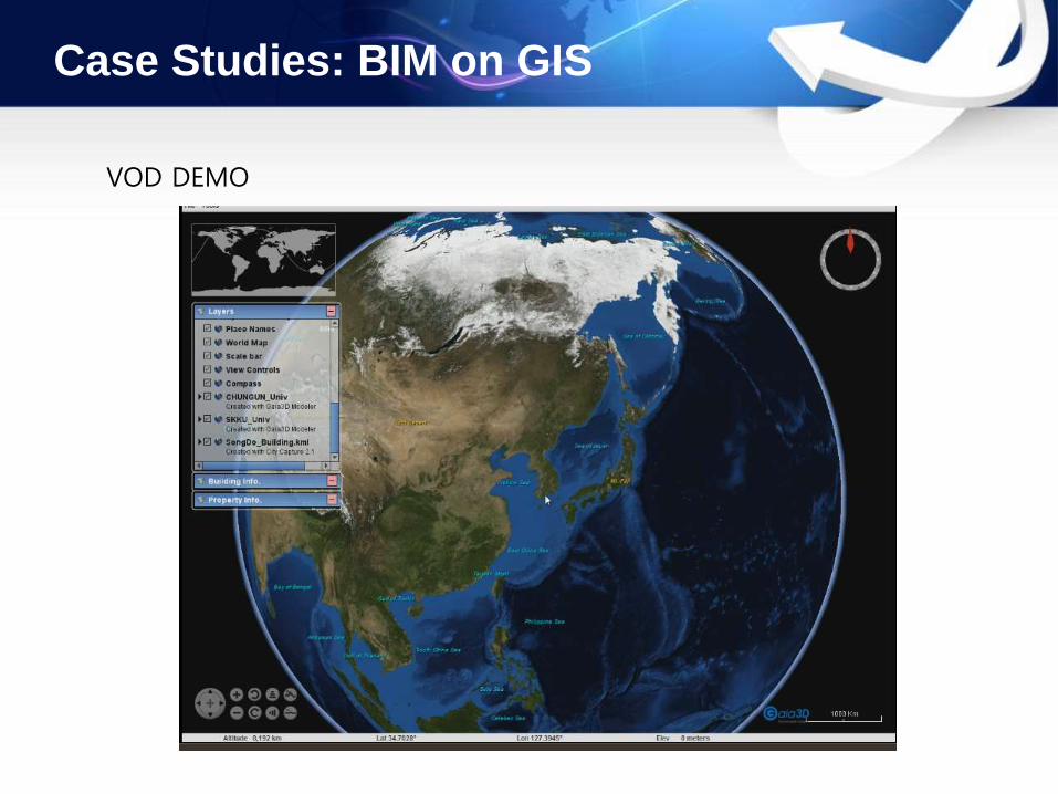
Case Studies: BIM on GIS
KICT (Korea Institute of Construction Technology): WWJ + GAIA3D App.
REVIT
UrbanSpace
Construct BIM DataFMS(Facility Management System)
with BIM on GIS
BIM on GIS(Building Information Model)

Epilogue
Open Source GIS is new way to construct GIS system.
Human Resource is a competitive factor in Open Source GIS.
South Korea is a good example for developing countries.
Suggestion- Cooperate with OSGEO- Establish Government Policy- Find Business Model with Open Source GIS IT Service