Morphosis(Santa Monica)
2
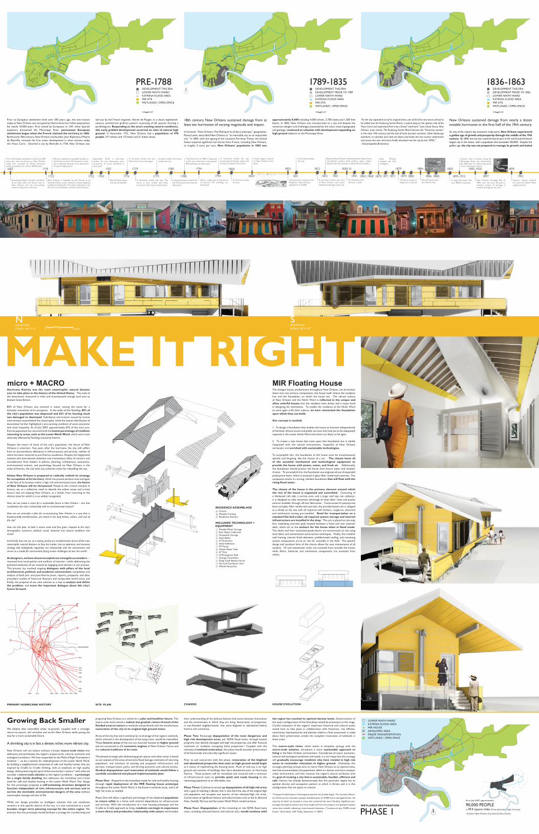
MAKE IT RIGHT 1722 September 22-24: a hurricane strikes the city destroying most structures. St. Louis Cathedral is destroyed. 1779 Another smaller hurricane strikes the city. 1682 Frenchman Robert Caralier and Sieur de La Salle claim the future area of New Orleans and the surrounding areas for King Louis of France. 1718 New Orleans is founded by the French as La Nouvelle-Orléans under direction of Jean-Baptiste Le Moyne de Bienville. The oldest cathedral in the US, St. Louis Cathedral, is built in New Orleans. 1762 New Orleans taken over by the Spanish. 1779 A hurricane strikes the city. The storm is very violent and many structures and crops are destroyed. 1780 A large hurricane strikes the city. Structures and crops are destroyed. 1722 Planners implement a gridded city plan in the French corridor. The French corridor site is selected because of its abuncance of natural high ground. Prior to European settlement a little over 200 years ago, the area known as New Orleans today was occupied by Native American Indian populations for nearly 10,000 years. 1788 The Great Fire of 1788: a large part of the city is burned to the ground. 856 buildings are destroyed. 1776 A hurricane strikes the city. Much of the city is damaged. 1740 1794 Again, a large part of city burns to ground. 212 buildings are destroyed. 1800 France regains control of New Orleans from Spain. 1794 A hurricane strikes the city producing hail. People, cattle, and horses are killed in the storm. 1815 Battle of New Orleans: Andrew Jackson leads French and Spanish settlers (with soldiers, slaves, militia, Indians and even pirates) to defeat British invaders. 1811 A hurricane strikes the city. 1803 US purchases Louisiana from Napoleon. New Orleans population is 10,000. 1800 A hurricane strikes the city. 1830-31 The Pontchartrain railroad is built. 1884 New Orleans hosts the World’s Fair. 1879 The Army Corps of Engineers is started. 1812 A hurricane strikes just west of New Orleans and causes substantial damage to the city. 1821 1831 1893-1915 Several miles of levees along the Mississippi River are constructed. By 1920, over 15 million cubic yards of dirt have been moved. 1899 Cypress swamp drained to create the Ninth Ward neighborhoods. 1895-1920 New Orleans Drainage Plan of 1895: over the next 20 years a complex system of drainage is created throughout the area. 1870 New Orleans annexes the City of Algiers. 1893 A large Hurricane kills over 2000 in Louisiana. 1865 1868 1871 1871 1879 1882 1886 1888 1897 1901 1974 1960 1916 1983 1969 1979 1915 1909 1879 1982 1985 1965 1982 1992 1916 1855 NEW ORLEANS SITE PLAN A B C 1 2 3 4 5 6 7 8 9 10 11 12 13 14 SOLAR SOUTH 3 Growing Back Smaller We believe that controlled urban re-growth, coupled with a strategic return-to-nature, will revitalize and enrich New Orleans while paving the way for a more sustainable future. A shrinking city is in fact a denser, richer, more vibrant city. New Orleans will not endure without a broad, macro-scale vision that addresses and synthesizes the region’s unique social, cultural, economic and ecological conditions. We have responded to the Make It Right Foundation’s initiative “…to be a catalyst for redevelopment of the Lower Ninth Ward, by building a neighborhood comprised of safe and healthy homes that are inspired by Cradle to Cradle thinking, with an emphasis on high quality design, while preserving the spirit of the community’s culture,” with what we consider a micro-scale solution to the region’s problems – a prototype for a single family dwelling that addresses the immediate and critical need for safe and healthy housing in the Lower Ninth Ward. Our design for this prototype proposes a self-sustaining structure designed to function independent of civic infrastructure and services and to survive the inevitable environmental dangers of the area without catastrophic damage and loss of life. While our design provides an intelligent solution that can accelerate recovery in this specific district of the city, it is also connected to a much broader, longer term planning concept for the entire region. We envision that this prototype would facilitate a strategy for transforming and micro + MACRO MIR Floating House Prior to European settlement little over 200 years ago, the area known today as New Orleans was occupied by Native American Indian populations for nearly 10,000 years. First visited by Europeans in 1541 when Spanish explorers discovered the Mississippi River, permanent European settlement began when the French claimed the territory in 1682. By the early 18th century, New Orleans city founder, Jean-Baptiste Le Moyne de Bienville, initiated the first urban development in what remains today the Vieux Carre. Decreed a city by Bienville in 1718, New Orleans was 18th century New Orleans sustained damage from at least ten hurricanes of varying magnitude and impact. In his book, “New Orleans: The Making of an Urban Landscape,” geographer, Peirce Lewis, described New Orleans as “an inevitable city on an impossible site.” In 1803, with the signing of the Louisiana Purchase Treaty, the United States acquired significant territories from France, including New Orleans, at roughly 3 cents per acre. New Orleans’ population in 1803 was laid out by the French engineer, Adrien de Pauger, in a classic eighteenth- century symmetrical gridiron pattern consisting of 66 squares forming a parallelogram. Responding to the area’s existing natural conditions, this early gridded development occurred on sites of natural high ground. In November 1721, New Orleans had a population of 470 people: 277 whites and 172 black and 21 Indian slaves. approximately 8,000 including 4,000 whites, 2,700 slaves and 1,300 free blacks. In 1805, New Orleans was incorporated as a city and despite the numerous dangers and challenges presented by the area’s natural geography and geology, continued to urbanize with development expanding on high ground adjacent to the Mississippi River. “As the city expanded out of its original limits, one of the first new tracts of land to be added was the Faubourg Sainte Marie, a suburb lying on the uptown side of the Vieux Carré and separated from it by a broad “commons” (now Canal Street, New Orleans’ main street). The Faubourg Sainte Marie became the “American section” in the early 19th century and the hub of most business activities. Other faubourgs (outskirts, or suburbs) were laid out above and below the two nuclear settlements and across the river and were finally absorbed into the city by the 1870s.” - Encyclopedia Britannica New Orleans sustained damage from nearly a dozen notable hurricanes in the first half of the 19th century. As one of the nation’s key economic trade ports, New Orleans experienced a golden age of growth and prosperity through the middle of the 19th century. By 1840, the city was rated the fourth port in the world and the fourth largest city in the nation, with a population that exceeded 100,000. Despite this golden age, the city was not prepared to manage its growth and lacked 0 1 5 10 FEET preparing New Orleans as a whole for a safer and healthier future. This macro-scale vision entails a radical, but gradual, return of much of the flooded areas to nature as wetlands and parklands with the simultaneous restoration of the city to its original high ground status. Areas of the city that were settled prior to drainage of the region’s wetlands, which ushered in the development of low lying areas, would be intensified. These historic areas of the city are naturally located on higher ground and are connected to the economic engines of New Orleans’ future and the cultural traditions of its roots. The phased strategic plan delineating green spaces and urban zones is based on our analysis of the areas of extreme flood damage, estimates of returning population, and locations of existing and proposed infrastructure and services, transportation, parks, and thriving economic and cultural activity. Gradual depopulation and restoration of wetlands would follow a carefully considered and phased implementation plan: Phase One: Respond to the immediate needs for safe and healthy housing through rapid deployment of the MIR floating house prototype throughout the Lower Ninth Ward, in the Eastern wetlands areas, and in all high risk areas as needed. Phase One will allow a significant percentage of the displaced population to return safely to a home with minimal dependence on infrastructure and services. With the introduction of a new housing prototype and the Cradle to Cradle approach to living, residents can begin to experience a more direct and productive relationship with nature and broaden their understanding of the delicate balance that exists between themselves and the environment in which they are living. Restoration of properties, in non-flooded neighborhoods, that were blighted or abandoned before Katrina will commence. Phase Two: Encourage depopulation of the most dangerous and high risk development areas, per FEMA flood zones, through buyout programs that identify damaged and high risk properties and offer financial incentives to residents occupying these properties.* Coupled with the initiation of wetland restoration, this phase would consider preservation of all historically and culturally significant assets. Prior to and concurrent with this phase, restoration of the blighted and abandoned properties that exist on high ground would begin as a means of replenishing the housing stock. Much of mid-city is on high ground and consists of buildings that were abandoned prior to Hurricane Katrina. These projects will be revitalized and restored with a minimum of infrastructural costs to provide quick and ready housing to the relocating population at an affordable rate. Phase Three: Continue to encourage depopulation of all high risk areas with a goal of reaching a density that is one-third the size of the original high risk population and occupies one quarter of low elevation/high risk areas. Conservation of significant historic and cultural assets such as the St. Bernard Area, Gentilly Terrace and the Lower Ninth Ward, would continue. Phase Four: Depopulation of the remaining at risk FEMA flood zone areas, including selected historic and cultural sites, would continue until the region has reached its optimal density levels. Determination of the exact configuration of this final phase would be premature at this stage. Careful evaluation of the region’s important historical and cultural assets would have to take place in collaboration with historians, city officials, community representatives and planners before a final assessment is made about their preservation amidst the complete restoration of wetlands in these areas. This macro-scale vision, which works in complete synergy with the micro-scale solution, introduces a more sustainable approach to living in the New Orleans environment. Considerate of social, economic, cultural and ecological conditions and needs, it is our hope that this strategy will gradually encourage residents who have resided in high risk zones to reconsider relocation to higher ground. Ultimately, this strategic planning concept aims to return New Orleans to an optimal state, one that accommodates the population, albeit in a denser and more compact urban environment, and that restores the region’s natural attributes with the goal of creating a city that is sustainable, feasible, efficient and safe. History has already demonstrated that this particular region has an optimal density and occupation pattern at which it thrives and it is this configuration that we aspire to restore. *Taxpayer-funded buyout of damaged properties has already begun. The Louisiana Recov- ery Authority has overseen taxpayer-funded buyout of 19,000 storm-damaged homes, the majority of which are located in areas that sustained the worst flooding. Significant per- centages of property owners who have sought aid from this program are opting for buyout rather than rebuild, indicating a trend toward relocation. (“Louisiana to buy 19,000 ruined homes,” Brad Heath, USA Today, September 17, 2007) Hurricane Katrina was the most catastrophic natural disaster ever to take place in the history of the United States. The scale of the devastation measured in miles and encompassed enough land area to blanket Great Britain. 80% of New Orleans was covered in water, setting the scene for a dramatic evacuation of its occupants. In the wake of this flooding, 85% of the city’s population was dispersed and 62% of its housing stock was damaged or destroyed. Subsidence and erosion caused by human interventions exacerbated the catastrophe, while the uneven distribution of devastation further highlighted a pre-existing condition of socio-economic and racial inequality. As of July 2007, approximately 67% of the city’s pre- Katrina population has returned with the lowest percentage of residents returning to areas, such as the Lower Ninth Ward, which were most adversely affected by flooding caused by Katrina. Despite the return of much of the city’s population, the future of New Orleans is uncertain. Two years after the hurricane, the city still suffers from an extraordinary deficiency in infrastructure and services, neither of which has been restored to pre-Katrina conditions. Despite the heightened national and international attention and tremendous influx of concern and consideration from leaders in politics, planning, architecture, economics, environmental science, and psychology focused on New Orleans in the wake of Katrina, the city lacks any coherent vision for rebuilding the city. Unless New Orleans is prepared to radically rethink its strategy for occupation of its territory, which has proven perilous time and again in the face of its location within a high risk environmental zone, the future of New Orleans will be threatened. Poised at this critical moment in history, we, as a collective, need to identify the salient issues and critical factors that are keeping New Orleans, as a whole, from returning to the vibrant state for which it is so widely recognized. How can we create a vision for a sustainable future in New Orleans – one that recalibrates the city’s relationship with its environmental context? How can we articulate a plan for re-constituting New Orleans in a way that is fundamentally transformative, yet rooted in the long history, culture, and soul of the city? How can this plan, at both a macro scale and fine grain, respond to the city’s demographic, economic, political, social, historical and cultural conditions and needs? And finally, how can we, as a society, parlay our transformation of one of the most catastrophic natural disasters to face this nation, into an optimistic and visionary strategy that intelligently negotiates our relationship with the environment and serves as a model for communities facing similar challenges all over the world? As designers, we have chosen to exploit our strengths as outsiders— removed from local politics and conflicts of interest—while addressing the potential weakness of our naiveté by engaging local advisors in our process. This process has involved ongoing dialogues with pillars of the local architectural, political, and academic communities; compilation and analysis of both pre- and post-Katrina press, reports, proposals, and data; precedent studies of historical disasters and comparable world cities; and finally, the proposal of our own solution as a way to analyze and define the problem, and move the important dialogue about this city’s future forward. The shotgun house, predominant throughout New Orleans, can be broken down into two primary components: the house itself, where the residents live; and the foundation, on which the house sits. The vibrant culture of New Orleans and the Ninth Ward is reflected in the unique and often colorful houses that the residents have always had a major hand in designing for themselves. To enable the residents of the Ninth Ward to once again craft their culture, we have reinvented the foundation upon which they can build. Our concept is twofold: 1. To design a foundation that enables the house to function independently of the basic infrastructure and public services that have yet to be adequately repaired in the Lower Ninth Ward and which are likely to fail again. 2. To create a new house that rests upon that foundation but is wholly integrated with the natural environment, respectful of New Orleans vernacular, and enriched with sustainable technologies. To accomplish this, the foundation of the house must be simultaneously specific and forgiving, like the chassis of a car. The chassis hosts all of the essential mechanical and technological equipment to provide the house with power, water, and fresh air. Additionally, the foundation should protect the house from future water and weather threats. To accomplish this, the foundation was engineered out of expanded polystyrene foam, which is encased in glass fiber reinforced concrete. This composite results in a strong, resilient foundation that will float with the rising flood water. The chassis of the house is the primary element around which the rest of the house is organized and assembled. Consisting of a thickened raft slab, a service core, and a large roof top rain collector, it is designed to take maximum advantage of shop labor rates and quality control available through off-site fabrication. Constructed of polystyrene foam and glass fiber reinforced concrete, the pre-fabricated unit is shipped as a whole to the site with all required wall anchors, rough-ins, electrical and mechanical routing pre-installed. Sized for transportation on a standard flat bed trailer, all required system storage and internal infrastructure are installed in the shop. The unit is placed on site atop four stabilizing concrete pads located between a front and rear exterior deck, which act as the anchors for the house when in flood mode. The decks and their associated grade beams are constructed on site using local labor and conventional construction techniques. Finally, the modular wall framing, interior finish elements, prefabricated roofing, and remaining system components arrive on site for assembly in the field. The specific design and resultant form of the chassis allows for easy maintenance of all systems. LP and wastewater tanks are accessed from outside the house, while filters, batteries and mechanical components are accessed from within. DEVELOPMENT THIS ERA LOWER NINTH WARD KATRINA FLOOD AREA MIR SITE WETLANDS / OPEN SPACE PRE-1788 1789-1835 DEVELOPMENT THIS ERA DEVELOPMENT PRIOR TO 1789 LOWER NINTH WARD KATRINA FLOOD AREA MIR SITE WETLANDS / OPEN SPACE 1836-1863 DEVELOPMENT THIS ERA DEVELOPMENT PRIOR TO 1836 LOWER NINTH WARD KATRINA FLOOD AREA MIR SITE WETLANDS / OPEN SPACE S ELEVATION SCALE: 1/8”=1’-0” N ELEVATION SCALE: 1/8”=1’-0” PHASE 1 WETLANDS RESTORATION LOWER NINTH WARD KATRINA FLOOD AREA MIR HOUSE DEVELOPED AREA MAJOR TRANSPORTATION WETLANDS / OPEN SPACE As of July 2007, approximately in 49.4 square miles of low elevation / high risk areas -Greater New Orleans Community Data Center 90,000 PEOPLE PRIMARY HURRICANE HISTORY HOUSE EVOLUTION CHASSIS C B A 8 6 7 5 4 3 2 1 9 10 11 12 13 14 Chassis Modular Framing Residence Anchors Potable Water Storage Rain Water Collection Greywater Storage Solar Boiler LP Generator Solar Sollectors PV Panels Waste Water Tank LP Tank LP Emergency Tank Charge Controllers Deep Cycle Battery Array Fan Coil Condenser Unit Whole House Fan RESIDENCE ASSEMBLAGE INCLUDED TECHNOLOGY + EQUIPMENT 0 0.5 0 0.5 miles 0 0.5 N N
-
Upload
damian-111093 -
Category
Education
-
view
124 -
download
0
Transcript of Morphosis(Santa Monica)
MAKE IT RIGHT
1722
September 22-24: a hurricane strikes the city destroying most structures. St. Louis Cathedral is destroyed.
1779
Another smaller hurricane strikes the city.
1682
Frenchman Robert Caralier and Sieur de La Salle claim the future area of New Orleans and the surrounding areas for King Louis of France.
1718
New Orleans is founded by the French as La Nouvelle-Orléans under direction of Jean-Baptiste Le Moyne de Bienville. The oldest cathedral in the US, St. Louis Cathedral, is built in New Orleans.
1762
New Orleans taken over by the Spanish.
1779
A hurricane strikes the city. The storm is very violent and many structures and crops are destroyed.
1780
A large hurricane strikes the city. Structures and crops are destroyed.
1722
Planners implement a gridded city plan in the French corridor. The French corridor site is selected because of its abuncance of natural high ground.
Prior to European settlement a little over 200 years ago, the area known as New Orleans today was occupied by Native American Indian populations for nearly 10,000 years.
1788
The Great Fire of 1788: a large part of the city is burned to the ground. 856 buildings are destroyed.
1776
A hurricane strikes the city.Much of the city is damaged.
1740
1794
Again, a large part of city burns to ground. 212 buildings are destroyed.
1800
France regains control of New Orleans from Spain.
1794
A hurricane strikes the city producing hail. People, cattle, and horses are killed in the storm.
1815
Battle of New Orleans: Andrew Jackson leads French and Spanish settlers (with soldiers, slaves, militia, Indians and even pirates) to defeat British invaders.
1811
A hurricane strikes the city.
1803
US purchases Louisiana from Napoleon. New Orleans population is 10,000.
1800
A hurricane strikes the city.
1830-31
The Pontchartrain railroad is built.
1884
New Orleans hosts the World’s Fair.
1879
The Army Corps of Engineers is started.
1812
A hurricane strikes just west of New Orleans and causes substantial damage to the city.
1821 1831 1893-1915
Several miles of levees along the Mississippi River are constructed. By 1920, over 15 million cubic yards of dirt have been moved.
1899
Cypress swamp drained to create the Ninth Ward neighborhoods.
1895-1920
New Orleans Drainage Plan of 1895: over the next 20 years a complex system of drainage is created throughout the area.
1870
New Orleans annexes the City of Algiers.
1893
A large Hurricane kills over 2000 in Louisiana.
1865 1868 1871 1871 1879 1882 1886 1888 1897 1901
19741960 19161983 1969 1979 1915 19091879
1982
1985
1965
1982
19921916
1855
NEW ORLEANS
SITE PLAN
A
B
C
1
2
3
4
5
6
7
8
9
10
11
12
13
14
SOLAR SOUTH
3
Growing Back SmallerWe believe that controlled urban re-growth, coupled with a strategic return-to-nature, will revitalize and enrich New Orleans while paving the way for a more sustainable future.
A shrinking city is in fact a denser, richer, more vibrant city.
New Orleans will not endure without a broad, macro-scale vision that addresses and synthesizes the region’s unique social, cultural, economic and ecological conditions. We have responded to the Make It Right Foundation’s initiative “…to be a catalyst for redevelopment of the Lower Ninth Ward, by building a neighborhood comprised of safe and healthy homes that are inspired by Cradle to Cradle thinking, with an emphasis on high quality design, while preserving the spirit of the community’s culture,” with what we consider a micro-scale solution to the region’s problems – a prototype for a single family dwelling that addresses the immediate and critical need for safe and healthy housing in the Lower Ninth Ward. Our design for this prototype proposes a self-sustaining structure designed to function independent of civic infrastructure and services and to survive the inevitable environmental dangers of the area without catastrophic damage and loss of life.
While our design provides an intelligent solution that can accelerate recovery in this specific district of the city, it is also connected to a much broader, longer term planning concept for the entire region. We envision that this prototype would facilitate a strategy for transforming and
micro + MACRO MIR Floating House
Prior to European settlement little over 200 years ago, the area known today as New Orleans was occupied by Native American Indian populations for nearly 10,000 years. First visited by Europeans in 1541 when Spanish explorers discovered the Mississippi River, permanent European settlement began when the French claimed the territory in 1682. By the early 18th century, New Orleans city founder, Jean-Baptiste Le Moyne de Bienville, initiated the first urban development in what remains today the Vieux Carre. Decreed a city by Bienville in 1718, New Orleans was
18th century New Orleans sustained damage from at least ten hurricanes of varying magnitude and impact.
In his book, “New Orleans: The Making of an Urban Landscape,” geographer, Peirce Lewis, described New Orleans as “an inevitable city on an impossible site.” In 1803, with the signing of the Louisiana Purchase Treaty, the United States acquired significant territories from France, including New Orleans, at roughly 3 cents per acre. New Orleans’ population in 1803 was
laid out by the French engineer, Adrien de Pauger, in a classic eighteenth-century symmetrical gridiron pattern consisting of 66 squares forming a parallelogram. Responding to the area’s existing natural conditions, this early gridded development occurred on sites of natural high ground. In November 1721, New Orleans had a population of 470 people: 277 whites and 172 black and 21 Indian slaves.
approximately 8,000 including 4,000 whites, 2,700 slaves and 1,300 free blacks. In 1805, New Orleans was incorporated as a city and despite the numerous dangers and challenges presented by the area’s natural geography and geology, continued to urbanize with development expanding on high ground adjacent to the Mississippi River.
“As the city expanded out of its original limits, one of the first new tracts of land to be added was the Faubourg Sainte Marie, a suburb lying on the uptown side of the Vieux Carré and separated from it by a broad “commons” (now Canal Street, New Orleans’ main street). The Faubourg Sainte Marie became the “American section” in the early 19th century and the hub of most business activities. Other faubourgs (outskirts, or suburbs) were laid out above and below the two nuclear settlements and across the river and were finally absorbed into the city by the 1870s.” - Encyclopedia Britannica
New Orleans sustained damage from nearly a dozen notable hurricanes in the first half of the 19th century.
As one of the nation’s key economic trade ports, New Orleans experienced a golden age of growth and prosperity through the middle of the 19th century. By 1840, the city was rated the fourth port in the world and the fourth largest city in the nation, with a population that exceeded 100,000. Despite this golden age, the city was not prepared to manage its growth and lacked
0 1 5 10 FEET
preparing New Orleans as a whole for a safer and healthier future. This macro-scale vision entails a radical, but gradual, return of much of the flooded areas to nature as wetlands and parklands with the simultaneous restoration of the city to its original high ground status.
Areas of the city that were settled prior to drainage of the region’s wetlands, which ushered in the development of low lying areas, would be intensified. These historic areas of the city are naturally located on higher ground and are connected to the economic engines of New Orleans’ future and the cultural traditions of its roots.
The phased strategic plan delineating green spaces and urban zones is based on our analysis of the areas of extreme flood damage, estimates of returning population, and locations of existing and proposed infrastructure and services, transportation, parks, and thriving economic and cultural activity. Gradual depopulation and restoration of wetlands would follow a carefully considered and phased implementation plan:
Phase One: Respond to the immediate needs for safe and healthy housing through rapid deployment of the MIR floating house prototype throughout the Lower Ninth Ward, in the Eastern wetlands areas, and in all high risk areas as needed.
Phase One will allow a significant percentage of the displaced population to return safely to a home with minimal dependence on infrastructure and services. With the introduction of a new housing prototype and the Cradle to Cradle approach to living, residents can begin to experience a more direct and productive relationship with nature and broaden
their understanding of the delicate balance that exists between themselves and the environment in which they are living. Restoration of properties, in non-flooded neighborhoods, that were blighted or abandoned before Katrina will commence.
Phase Two: Encourage depopulation of the most dangerous and high risk development areas, per FEMA flood zones, through buyout programs that identify damaged and high risk properties and offer financial incentives to residents occupying these properties.* Coupled with the initiation of wetland restoration, this phase would consider preservation of all historically and culturally significant assets.
Prior to and concurrent with this phase, restoration of the blighted and abandoned properties that exist on high ground would beginas a means of replenishing the housing stock. Much of mid-city is on high ground and consists of buildings that were abandoned prior to Hurricane Katrina. These projects will be revitalized and restored with a minimum of infrastructural costs to provide quick and ready housing to the relocating population at an affordable rate.
Phase Three: Continue to encourage depopulation of all high risk areas with a goal of reaching a density that is one-third the size of the original high risk population and occupies one quarter of low elevation/high risk areas. Conservation of significant historic and cultural assets such as the St. Bernard Area, Gentilly Terrace and the Lower Ninth Ward, would continue.
Phase Four: Depopulation of the remaining at risk FEMA flood zone areas, including selected historic and cultural sites, would continue until
the region has reached its optimal density levels. Determination of the exact configuration of this final phase would be premature at this stage. Careful evaluation of the region’s important historical and cultural assets would have to take place in collaboration with historians, city officials, community representatives and planners before a final assessment is made about their preservation amidst the complete restoration of wetlands in these areas.
This macro-scale vision, which works in complete synergy with the micro-scale solution, introduces a more sustainable approach to living in the New Orleans environment. Considerate of social, economic, cultural and ecological conditions and needs, it is our hope that this strategy will gradually encourage residents who have resided in high risk zones to reconsider relocation to higher ground. Ultimately, this strategic planning concept aims to return New Orleans to an optimal state, one that accommodates the population, albeit in a denser and more compact urban environment, and that restores the region’s natural attributes with the goal of creating a city that is sustainable, feasible, efficient and safe. History has already demonstrated that this particular region has an optimal density and occupation pattern at which it thrives and it is this configuration that we aspire to restore.
*Taxpayer-funded buyout of damaged properties has already begun. The Louisiana Recov-
ery Authority has overseen taxpayer-funded buyout of 19,000 storm-damaged homes, the
majority of which are located in areas that sustained the worst flooding. Significant per-
centages of property owners who have sought aid from this program are opting for buyout
rather than rebuild, indicating a trend toward relocation. (“Louisiana to buy 19,000 ruined
homes,” Brad Heath, USA Today, September 17, 2007)
Hurricane Katrina was the most catastrophic natural disaster ever to take place in the history of the United States. The scale of the devastation measured in miles and encompassed enough land area to blanket Great Britain.
80% of New Orleans was covered in water, setting the scene for a dramatic evacuation of its occupants. In the wake of this flooding, 85% of the city’s population was dispersed and 62% of its housing stock was damaged or destroyed. Subsidence and erosion caused by human interventions exacerbated the catastrophe, while the uneven distribution of devastation further highlighted a pre-existing condition of socio-economic and racial inequality. As of July 2007, approximately 67% of the city’s pre-Katrina population has returned with the lowest percentage of residents returning to areas, such as the Lower Ninth Ward, which were most adversely affected by flooding caused by Katrina.
Despite the return of much of the city’s population, the future of New Orleans is uncertain. Two years after the hurricane, the city still suffers from an extraordinary deficiency in infrastructure and services, neither of which has been restored to pre-Katrina conditions. Despite the heightened national and international attention and tremendous influx of concern and consideration from leaders in politics, planning, architecture, economics, environmental science, and psychology focused on New Orleans in the wake of Katrina, the city lacks any coherent vision for rebuilding the city.
Unless New Orleans is prepared to radically rethink its strategy for occupation of its territory, which has proven perilous time and again in the face of its location within a high risk environmental zone, the future of New Orleans will be threatened. Poised at this critical moment in history, we, as a collective, need to identify the salient issues and critical factors that are keeping New Orleans, as a whole, from returning to the vibrant state for which it is so widely recognized.
How can we create a vision for a sustainable future in New Orleans – one that recalibrates the city’s relationship with its environmental context?
How can we articulate a plan for re-constituting New Orleans in a way that is fundamentally transformative, yet rooted in the long history, culture, and soul of the city?
How can this plan, at both a macro scale and fine grain, respond to the city’s demographic, economic, political, social, historical and cultural conditions and needs?
And finally, how can we, as a society, parlay our transformation of one of the most catastrophic natural disasters to face this nation, into an optimistic and visionary strategy that intelligently negotiates our relationship with the environment and serves as a model for communities facing similar challenges all over the world? As designers, we have chosen to exploit our strengths as outsiders—removed from local politics and conflicts of interest—while addressing the potential weakness of our naiveté by engaging local advisors in our process. This process has involved ongoing dialogues with pillars of the local architectural, political, and academic communities; compilation and analysis of both pre- and post-Katrina press, reports, proposals, and data; precedent studies of historical disasters and comparable world cities; and finally, the proposal of our own solution as a way to analyze and define the problem, and move the important dialogue about this city’s future forward.
The shotgun house, predominant throughout New Orleans, can be broken down into two primary components: the house itself, where the residents live; and the foundation, on which the house sits. The vibrant culture of New Orleans and the Ninth Ward is reflected in the unique and often colorful houses that the residents have always had a major hand in designing for themselves. To enable the residents of the Ninth Ward to once again craft their culture, we have reinvented the foundation upon which they can build.
Our concept is twofold:
1. To design a foundation that enables the house to function independently of the basic infrastructure and public services that have yet to be adequately repaired in the Lower Ninth Ward and which are likely to fail again.
2. To create a new house that rests upon that foundation but is wholly integrated with the natural environment, respectful of New Orleans vernacular, and enriched with sustainable technologies.
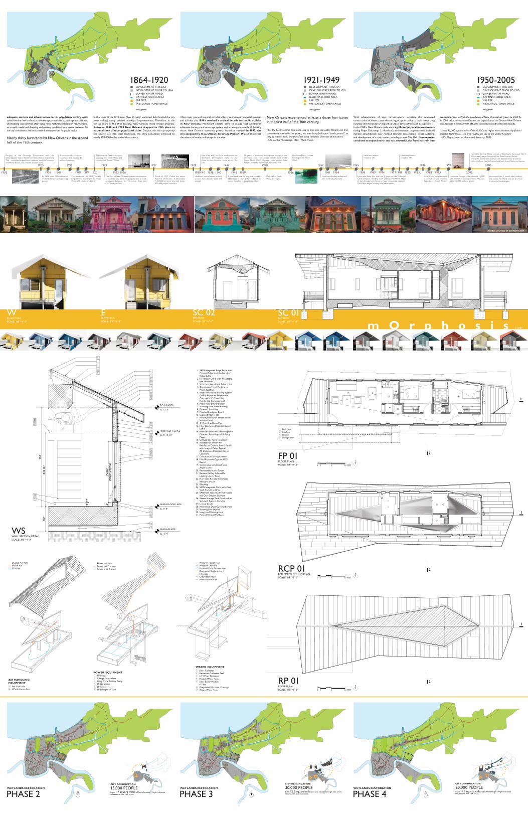
To accomplish this, the foundation of the house must be simultaneously specific and forgiving, like the chassis of a car. The chassis hosts all of the essential mechanical and technological equipment to provide the house with power, water, and fresh air. Additionally, the foundation should protect the house from future water and weather threats. To accomplish this, the foundation was engineered out of expanded polystyrene foam, which is encased in glass fiber reinforced concrete. This composite results in a strong, resilient foundation that will float with the rising flood water.
The chassis of the house is the primary element around which the rest of the house is organized and assembled. Consisting of a thickened raft slab, a service core, and a large roof top rain collector, it is designed to take maximum advantage of shop labor rates and quality control available through off-site fabrication. Constructed of polystyrene foam and glass fiber reinforced concrete, the pre-fabricated unit is shipped as a whole to the site with all required wall anchors, rough-ins, electrical and mechanical routing pre-installed. Sized for transportation on a standard flat bed trailer, all required system storage and internal infrastructure are installed in the shop. The unit is placed on site atop four stabilizing concrete pads located between a front and rear exterior deck, which act as the anchors for the house when in flood mode. The decks and their associated grade beams are constructed on site using local labor and conventional construction techniques. Finally, the modular wall framing, interior finish elements, prefabricated roofing, and remaining system components arrive on site for assembly in the field. The specific design and resultant form of the chassis allows for easy maintenance of all systems. LP and wastewater tanks are accessed from outside the house, while filters, batteries and mechanical components are accessed from within.
DEVELOPMENT THIS ERALOWER NINTH WARDKATRINA FLOOD AREAMIR SITEWETLANDS / OPEN SPACE
PRE-1788 1789-1835 DEVELOPMENT THIS ERA DEVELOPMENT PRIOR TO 1789LOWER NINTH WARDKATRINA FLOOD AREAMIR SITEWETLANDS / OPEN SPACE
1836-1863 DEVELOPMENT THIS ERA DEVELOPMENT PRIOR TO 1836LOWER NINTH WARDKATRINA FLOOD AREAMIR SITEWETLANDS / OPEN SPACE
SELEVATIONSCALE: 1/8”=1’-0”
N ELEVATIONSCALE: 1/8”=1’-0”
PHASE 1 WETLANDS RESTORATION
LOWER NINTH WARDKATRINA FLOOD AREAMIR HOUSEDEVELOPED AREAMAJOR TRANSPORTATIONWETLANDS / OPEN SPACE
As of July 2007, approximately
in 49.4 square miles of low elevation / high risk areas
-Greater New Orleans Community Data Center
90,000 PEOPLE
PRIMARY HURRICANE HISTORY HOUSE EVOLUTIONCHASSIS
C
B
A
8
6
7
5
4
3
2
1
9
10
11
12
13
14
ChassisModular FramingResidence Anchors
Potable Water StorageRain Water CollectionGreywater StorageSolar BoilerLP GeneratorSolar SollectorsPV PanelsWaste Water TankLP TankLP Emergency TankCharge ControllersDeep Cycle Battery ArrayFan Coil Condenser UnitWhole House Fan
RESIDENCE ASSEMBLAGE
INCLUDED TECHNOLOGY + EQUIPMENT
0 0.5 2.01.0
miles
0 0.5 2.01.0
miles
0 0.5 2.01.0
miles
N
N
m O r p h o s i s
1905
By 1905, over 22,000 acres of wetlands have been drained by pumps.
1915
The hurricane of 1915 creates long standing flooding in the Ninth Ward. 275 people are killed.
1903
Merging of the Drainage Commission with the Sewerage and Water Board for more efficient operations. This combined organization retained the title Sewerage and Water Board, and remains as such today.
1920
The Industrial Canal is dredged, bisecting the Ninth Ward and creating the “Lower” Ninth.
1909
A hurricane kills 353 across Louisiana and causes $5 million in damage.
1906 19191918
1950
Only half of Ninth Ward developed.
1957
Hurricane Audrey strikes and kills hundreds of people.
1947
A hurricane hits the city and creates a 12 foot storm surge. Jefferson Parish has severe flooding. 51 people are killed.
1928
Lakefront improvement project creates the lakeside levee and seawall.
1927
Flood of 1927. Called the worst flood in US history. It devastates 1,300,000 acres of land and leaves 300,000 people homeless.
1923
The Port of New Orleans finishes construction of the Industrial Canal. Its purpose is to provide navigation between the Mississippi River and Lake Pontchartrain.
1956
Hurricane Flossy creates flooding in the Ninth Ward.
1950
50 years of intensive development begins in low elevation areas. These areas include parts of the Lower Ninth Ward, Edgelake / Little Woods, Lake Forest, and Lake Kenilworth, to name a few.
1930-40
Lake Vista and Lakeshore subdivisions are developed. Development starts to take place in low elevation areas across the city.
1923 1926 1938 1940 1948 2005
Hurricane Katrina. Three sources of flooding to the Lower Ninth Ward: (east) water flowed in from Saint Bernard Parish- (west) the Industrial Canal had two distinct major breaches- a block in from Florida Avenue and back from Claiborne Avenue.
1986
Holy Cross neighborhood is added to the National Register of Historic Places.
1998
Hurricane George. Approximatly 14,000 take shelter in the Superdome. Outages leave 260,000 without power.
2005
Hurricane Rita: 1 month after Katrina, the Lower 9th Ward, not yet dry from Katrina, is flooded again.
1965
Hurricane Betsy hits the city. A levee on the Industrial Canal collapses, flooding much of the Lower Ninth. Much of the damage from Betsy is never adequately repaired. The Corps begins building hurricane levees.
1969
Lakefront levee is raised to 12ft.
1981
Lakefront levee is raised to 18ft.
1961 1964 1969 1974 1977 1985 1985 1988 1995
1
2
3
4
5
6
1
2
3
4
5
6
pumping valve
7
2
1
images courtesy of asergeev.com
adequate services and infrastructure for its population: drinking water came from the river or cisterns; no sewerage system existed; drainage was deficient; and flooding was common after heavy rains. Natural conditions in New Orleans, as a result, made both flooding and sanitary conditions into severe problems for the city’s inhabitants, with catastrophic consequences for public health.
Nearly thirty hurricanes hit New Orleans in the second half of the 19th century.
In the wake of the Civil War, New Orleans’ municipal debt limited the city from making sorely needed municipal improvements. Therefore, in the last 20 years of the 19th century, New Orleans made limited progress. Between 1840 and 1900 New Orleans dropped to 12th place in national rank of most populated cities. Despite this lull in prosperity and amidst less than ideal conditions, the city’s population increased to nearly 290,000 by the end of the century.
After many years of minimal or failed efforts to improve municipal services and utilities, the 1890’s marked a critical decade for public utilities in New Orleans. Prominent citizens came to realize that without an adequate drainage and sewerage system and an adequate supply of drinking water, New Orleans’ economic growth would be stunted. In 1895, the city adopted the New Orleans Drainage Plan of 1895, which marked the advent of modern drainage in the city.
New Orleans experienced at least a dozen hurricanes in the first half of the 20th century.
“But the people cannot have wells, and so they take rain-water. Neither can they conveniently have cellars or graves, the town being built upon “made ground”; so they do without both, and few of the living complain, and none of the others.”- Life on the Mississippi, 1883 Mark Twain
SC 01 SECTIONSCALE: 1/8”=1’-0”
© 2007
SABS Integrated Ridge Beam with Precast Galvanized Anchors for Ridge Cable SS Tension Cable with Adjustable End Terminals Stretched Wire Mesh Fabric Filter Continuous Metal Flashing to Match Roofing Saebi Alternative Building System (SABS) Expanded Polystyrene Core with ¼” Glass Fiber Reinforced Concrete Shell Photovoltaic Panel System Standing Seam Metal Roofing Plywood Sheathing Finished Insulation Board Exposed Roof Joists Fiber Reinforced Cement Board Header Panel 1” Overflow Drain PipeFiber Reinforced Cement Board Soffit Modular Wood Wall Framing with Plywood Sheathing and Building Paper Sprayed Soy Foam Insulation Swisspearl Carrat Fiber Reinforced Cement Board Panels with Integral Color Typical All Designated Cement Board Locations. Continuous Furring Channel Mold Resistant Gypsum Wall Board Continuous Galvanized Steel Angle GuideRetractable Insect Screen Bottom Rolling Adjustable Locking Louver Panel Hurricane Resistant Insulated Window System Blocking SABS Integrated Curb with Cast Wall Anchor at 16”oc SABS Raft Slab with Prefabricated and Cast Systems Support Water Storage Tank Fixed to Raft Slab with Precast Anchors Line of Grade Mechanical Duct Opening BeyondSleeping Loft Beyond Integrated Shelving Unit Painted Wood Wall Base
1.
2.
3.4.
5.
6.7.8.9.
10.11.
12.13.
14.
15.16.
17.18.
19.
20.21.
22.
23.24.
25.
26.
27.28.29.30.31.
With advancement of civic infrastructure, including the continued construction of levees, came the seizing of opportunity to drain lower lying swamps and wetlands for expanded urban development and occupation.In the 1950’s, New Orleans underwent significant physical improvements during Mayor DeLesseps S. Morrison’s administration. Improvements included railroad consolidation; new railroad terminal construction, street widening, and development of a civic center, including a new City Hall. Development continued to expand north and east towards Lake Pontchartrain into
wetland areas. In 1950, the population of New Orleans had grown to 570,445. In 2005, prior to Hurricane Katrina, the population of the Greater New Orleans area reached 1.4 million with 485,000 residents located within city bounds.
“Some 90,000 square miles of the Gulf Coast region were blanketed by federal disaster declarations – an area roughly the size of the United Kingdom” -U.S. Department of Homeland Security, 2005
T.O. HEADER
FINISH LOFT LEVEL
FINISH FLOOR LEVEL
FINISH GRADE
EL. 12’-0”
EL. 8’-10 1/2”
EL. 0’-0”
EL. -3’-0”
1864-1920DEVELOPMENT THIS ERA DEVELOPMENT PRIOR TO 1864LOWER NINTH WARDKATRINA FLOOD AREAMIR SITEWETLANDS / OPEN SPACE
1921-1949DEVELOPMENT THIS ERA DEVELOPMENT PRIOR TO 1921LOWER NINTH WARDKATRINA FLOOD AREAMIR SITEWETLANDS / OPEN SPACE
1950-2005DEVELOPMENT THIS ERA DEVELOPMENT PRIOR TO 1950LOWER NINTH WARDKATRINA FLOOD AREAMIR SITEWETLANDS / OPEN SPACE
E ELEVATIONSCALE: 1/8”=1’-0”
WELEVATIONSCALE: 1/8”=1’-0”
SC 02 SECTIONSCALE: 1/8”=1’-0”
PHASE 4 WETLANDS RESTORATION
PHASE 3 WETLANDS RESTORATION
PHASE 2 WETLANDS RESTORATION
from 1.7 square miles of low elevation / high risk areas relocate to low risk areas.
CITY DENSIFICATION:
15,000 PEOPLEfrom 12.5 square miles of low elevation / high risk areas relocate to low risk areas.
30,000 PEOPLECITY DENSIFICATION:
from 11.1 square miles of low elevation / high risk areas relocate to low risk areas.
20,000 PEOPLECITY DENSIFICATION:
WSWALL SECTION DETAILSCALE: 3/8”=1’-0”
RP 01 ROOF PLANSCALE: 1/8”=1’-0” 0 1 5 10 FEET
N
FP 01 FLOOR PLANSCALE: 1/8”=1’-0”
RCP 01 REFLECTED CEILING PLANSCALE: 1/8”=1’-0” 0 1 5 10 FEET
0 1 5 10 FEET
N
N
Power In / SolarPower In / PropanePower Distribution
PV PanelsCharge ControllersDeep Cycle Battery ArrayLP GeneratorLP TanksLP Emergency Tank
POWER EQUIPMENT
6
5
4
3
2
1
0 0.5 2.01.0
miles
0 0.5 2.01.0
miles
0 0.5 2.01.0
miles
BedroomKitchen DiningLiving Room4
3
2
1
2
34
11
2
1
2
2
Water In / Solar HeatWater In / PotablePotable Water DistributionGreywater Reclamation / FiltrationGreywater ReuseWaste Water Out
Solar CollectorRainwater Collector TankUV Water FiltrationPotable Water TankSolar Boiler Module+ TankGreywater Filtration / StorageWaste Water Tank
WATER EQUIPMENT
6
5
4
3
2
1
7
Ducted Air PathWarm AirCool Air
Fan Coil UnitWhole House Fan
AIR HANDLING EQUIPMENT
2
1
1
1
N N N