Monitoring & Management of Forests in · PDF file · 2014-04-14Monitoring &...
38
Monitoring & Management of Forests in India Monitoring & Management of Forests in India Srinibas Patnaik Senior Director, SAARC [email protected] [email protected] M: +91 99161 39761 DigitalGlobe Proprietary and Business Confidential
Transcript of Monitoring & Management of Forests in · PDF file · 2014-04-14Monitoring &...

Monitoring & Management of Forests in IndiaMonitoring & Management of Forests in India
Srinibas PatnaikSenior Director, [email protected]@digitalglobe.com
M: +91 99161 39761
DigitalGlobe Proprietary and Business Confidential
Who we are
• World’s Leading Provider of High
Who we are
• World’s Leading Provider of High Resolution Satellite Imagery
• Delivering Imagery powered • Delivering Imagery powered Information and Insight Solutions
• Expanding Platform to facilitate new business and access models
DigitalGlobe Proprietary and Business Confidential 2
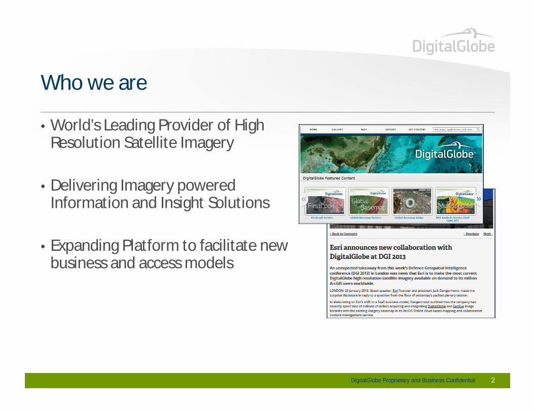
Advancing our industry one milestone at a timeAdvancing our industry one milestone at a time
1993U.S. Dept. of Commerce grants DigitalGlobe U.S. Dept. of Commerce grants DigitalGlobe first private enterprise license
QuickBird launches, The first commercial sub-meter
2008
2001GeoEye-1 launches
The first commercial sub-meter resolution satellite
2007DigitalGlobe acquiresGlobeXplorer, a leadingonline imagery provider
WorldView-1 launches1999IKONOS launches,
1992DigitalGlobe founded
2003
DigitalGlobe wins NextView contract to
WorldView-1 launchesIKONOS launches,The first commercial ~meter resolution satellite
DigitalGlobe Proprietary and Business Confidential 3
DigitalGlobe wins NextView contract tobuild and deliver data on WorldView-1
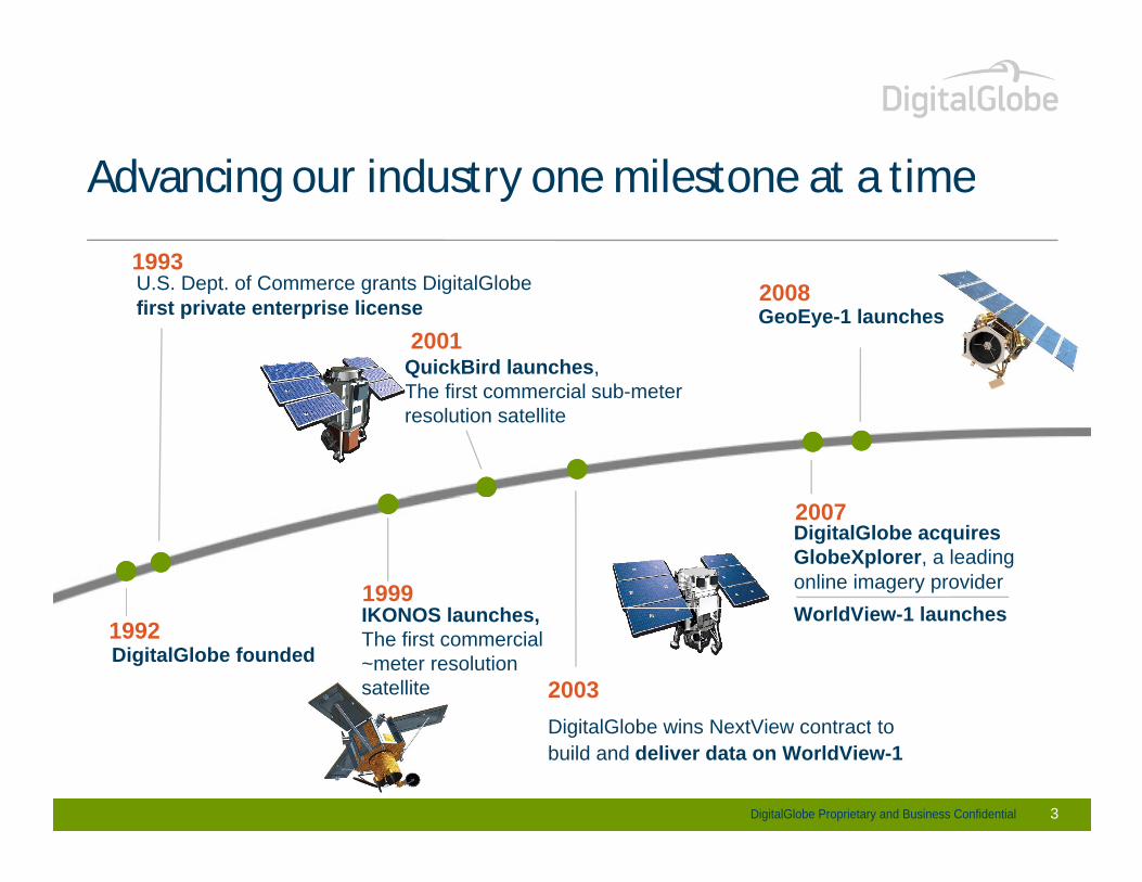
Advancing our industry one milestone at a timeAdvancing our industry one milestone at a time
2009DigitalGlobe opens 2010
2013/2014
DigitalGlobe opensLondon office and expands Singapore office
DigitalGlobe beginstrading as DGI on NYSE
2010DigitalGlobe surpasses one billion km2 of earth imagery
Estimated completiontrading as DGI on NYSE Estimated completionof WorldView-3 and GeoEye-2
20132009WorldView-2 launches
FirstLook launchesto provide the industry’s first information product
20132009DigitalGlobe and GeoEyemerge to make currently operating five satellites in low earth orbit
DigitalGlobe Proprietary and Business Confidential 4
first information productDigitalGlobe current archive3.8 Billion km2 of earth imagery
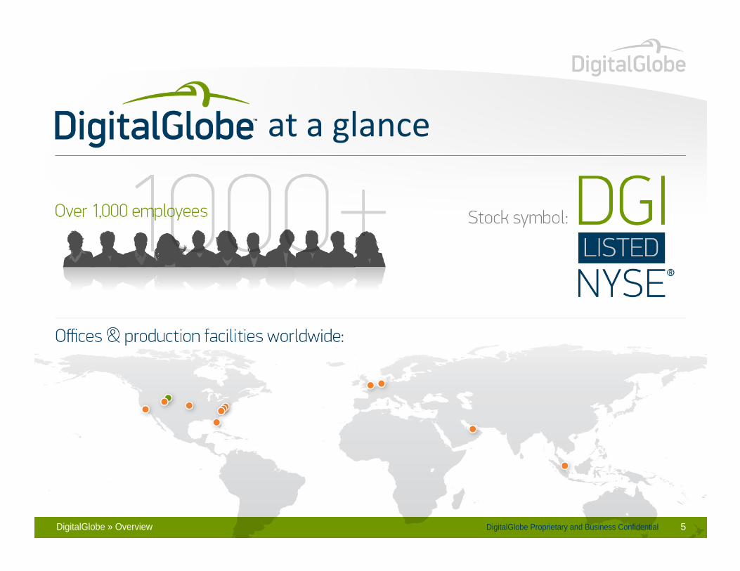
DigitalGlobe Proprietary and Business ConfidentialDigitalGlobe » Overview 5
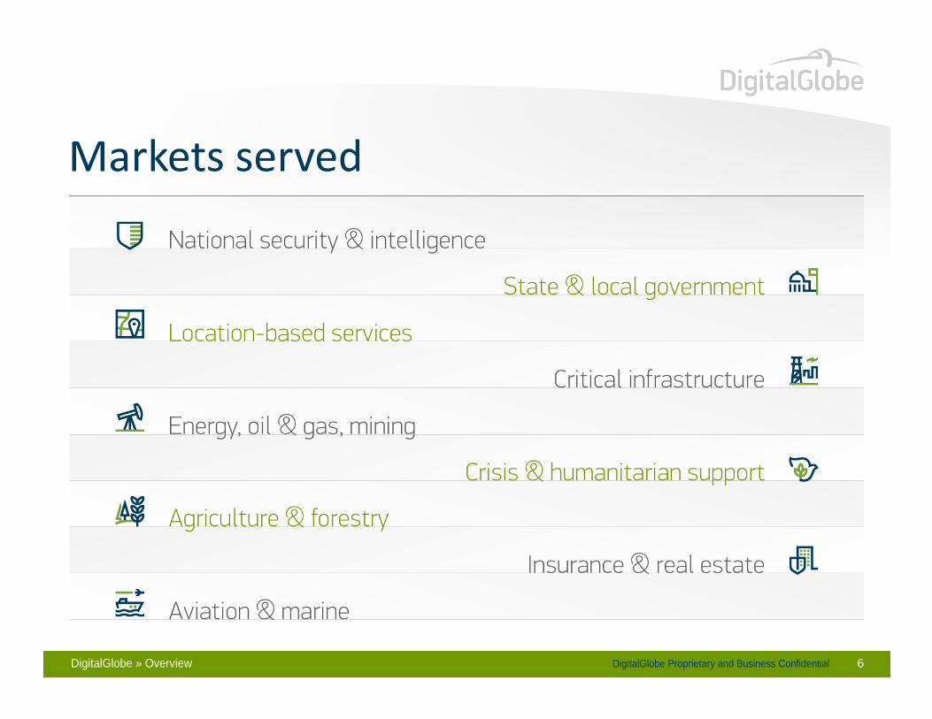
DigitalGlobe Proprietary and Business ConfidentialDigitalGlobe » Overview 6
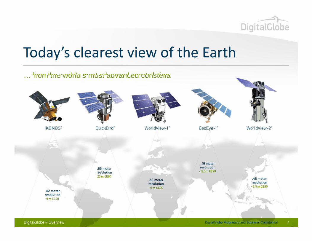
… from the world’s most advanced constellation:… from the world’s most advanced constellation:
DigitalGlobe Proprietary and Business ConfidentialDigitalGlobe » Overview 7

Upcoming DigitalGlobe Constellation AdditionsUpcoming DigitalGlobe Constellation Additions
GeoEye-2
WorldView-3Expected Completion 2014
16 band multispectral 31 cm resolution(1)
GeoEye-2Expected Completion 2013
4 band multispectral 34 cm resolution(1)
DigitalGlobe Proprietary and Business Confidential
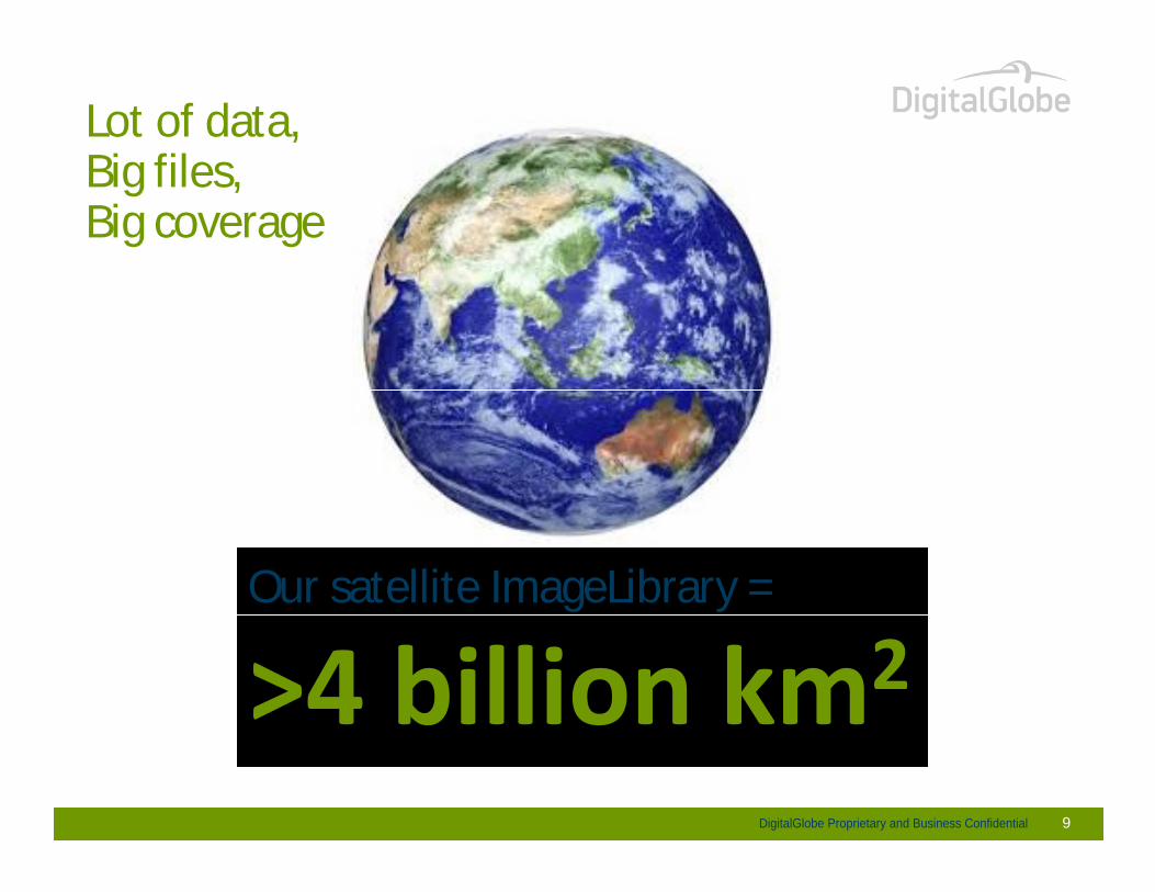
Lot of data,Big files,Big files,Big coverage
Our satellite ImageLibrary =
DigitalGlobe Proprietary and Business Confidential 9
DigitalGlobe Proprietary and Business Confidential 10
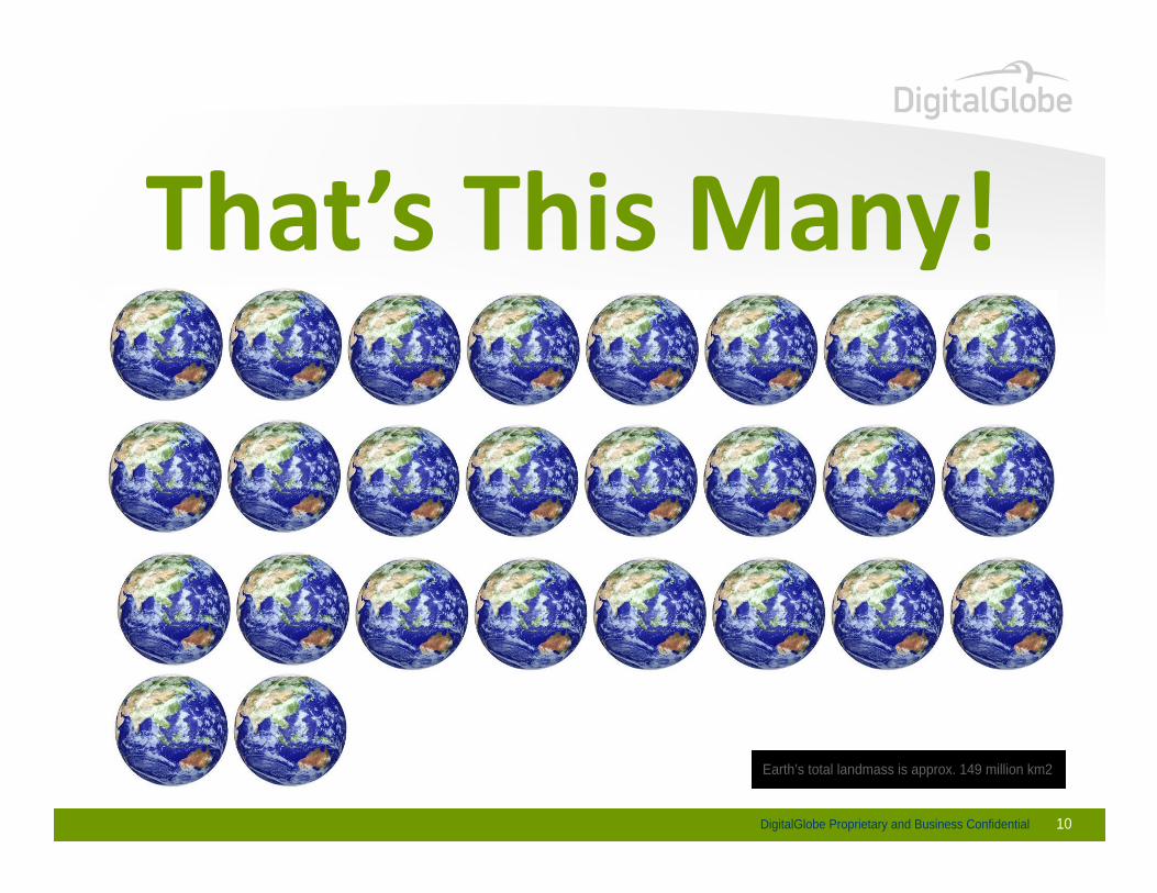
Earth’s total landmass is approx. 149 million km2

25 times all of the content in US academic research libraries 25 times all of the content in US academic research libraries The entire written works of mankind, from the beginning of recorded history, in all languages
DigitalGlobe Proprietary and Business Confidential 11
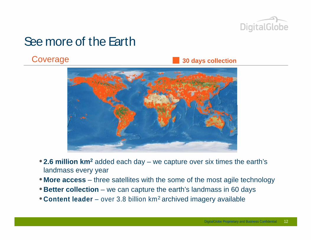
See more of the EarthSee more of the EarthCoverage 30 days collection
• 2.6 million km2 added each day – we capture over six times the earth’s •landmass every year
• More access – three satellites with the some of the most agile technology• Better collection – we can capture the earth’s landmass in 60 days• Content leader – over 3.8 billion km2 archived imagery available
DigitalGlobe Proprietary and Business Confidential 12
• Content leader – over 3.8 billion km2 archived imagery available

See the Earth nowSee the Earth now
Deliver images within hours after collection
Only companyoffering on-demandoffering on-demandaccess and download
Ability to refreshimagery from the same
DigitalGlobe Proprietary and Business Confidential 13
imagery from the samelocation almost daily
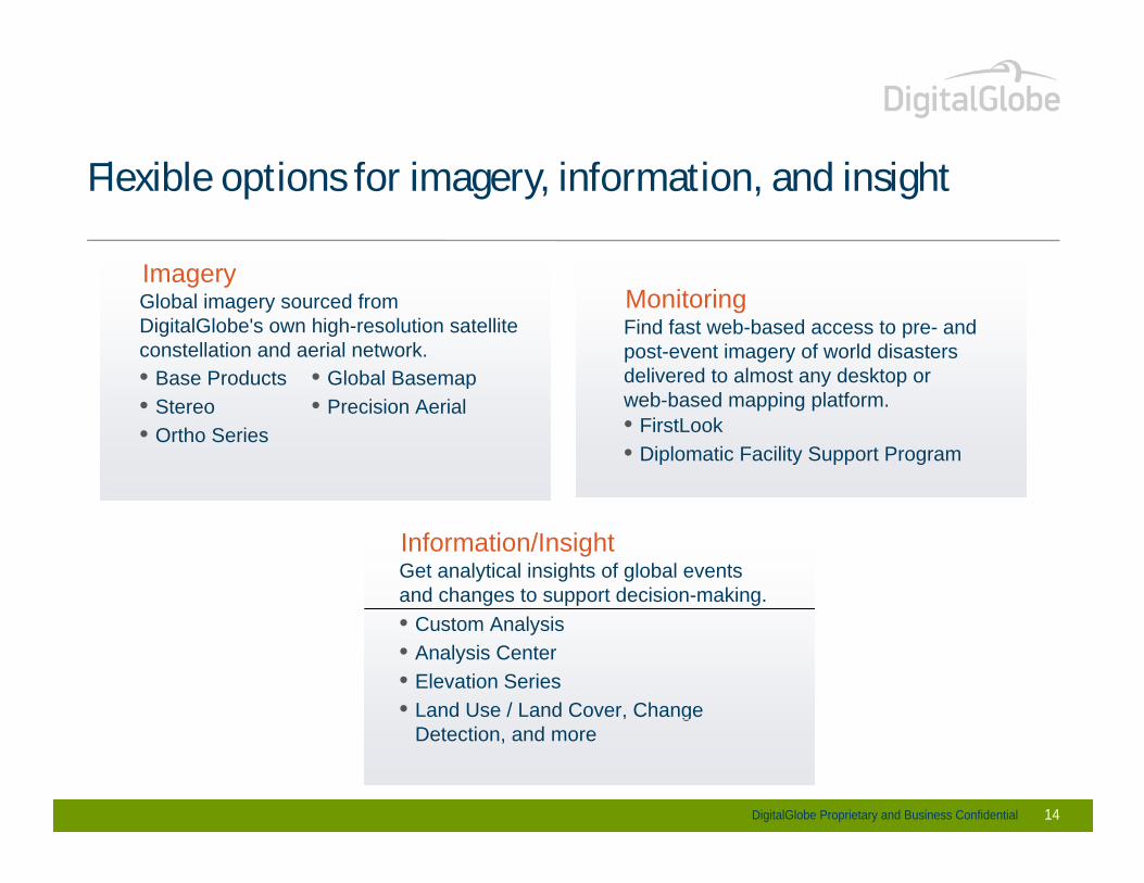
Flexible options for imagery, information, and insightFlexible options for imagery, information, and insight
ImageryImageryGlobal imagery sourced from DigitalGlobe's own high-resolution satellite constellation and aerial network.• Base Products • Global Basemap
MonitoringFind fast web-based access to pre- and post-event imagery of world disasters delivered to almost any desktop or • Base Products
• Stereo• Ortho Series
• Global Basemap• Precision Aerial
delivered to almost any desktop or web-based mapping platform.• FirstLook• Diplomatic Facility Support Program
Information/InsightGet analytical insights of global events and changes to support decision-making.
•• Custom Analysis• Analysis Center• Elevation Series• Land Use / Land Cover, Change
DigitalGlobe Proprietary and Business Confidential 14
• Land Use / Land Cover, Change Detection, and more

High Resolution Satellite Imagery for ForestryHigh Resolution Satellite Imagery for Forestry
DigitalGlobe Proprietary and Business Confidential

Forestry
• Customers
Forestry
• Customers- Developing Countries that need sustainable forestry/natural resources
management for conservation - Countries that need to meet nation demands in paper, oils and timber- Moving towards adoption of new technology and large scale monitoring of - Moving towards adoption of new technology and large scale monitoring of
resources
• Definit ion• Definit ion- Customers who want to do statewide/nationwide forestry management for:
- Understand Forestry Holdings in the State/Country and who owns what piece of landland
- Monitoring deforestation and degradation of forests and incentivize reforestation activities
- Plan commercial supply activities for paper, timber/wood and oils- Monitor illegal logging activity
DigitalGlobe Proprietary and Business Confidential
- Monitor illegal logging activity- Sustenance of urban green space to counter effects of pollution in cities

Forestry
• Importance
Forestry
• Importance- Maintain proper forestry records for state/national inventory of natural
resources- Enable self sufficiency and decrease foreign dependency on oil/paper/timber- Reduce deforestation by incentivizing reforestation activities- Reduce deforestation by incentivizing reforestation activities- Curb illegal logging/clearing activities- Identify illegal crop growth amid forestry
• Deficiencies or Needs- Nation / state wide inventory of forestry resources- Understanding of what type of forests exist where- Understanding of what type of forests exist where- Understanding of current growing conditions and impact on commercial
wood/paper supplies- Cohesive plan to support sustainability
DigitalGlobe Proprietary and Business Confidential
- Cohesive plan to support sustainability- Prevent fraud and exploitation

Forestry
• DigitalGlobe Value Proposition
Forestry
• DigitalGlobe Value Proposition- Accurate High Resolution Imagery to Map Nation /state wide Forests- Tree Species identification with WorldView class satellites with 8+ spectral
bandsbands- Planning disaster relief efforts in cases of landslides and forest fires- Economy of Scale
• Positioning- Worldview2 satellite designed primarily for vegetation identification- Automated Information Algorithms that need local expertise to create - Automated Information Algorithms that need local expertise to create
customer solutions and can help reserve agencies conserve their national assets/natural resources
DigitalGlobe Proprietary and Business Confidential 18
Forestry Issues Addressed
• Forest Resources
Forestry Issues Addressed
• Forest Resources • Yearly Estimation of Timber/Paper/Palm Oil• Illicit Crop Identification and Monitoring
Disaster relief efforts in cases of landslides and forest fires• Disaster relief efforts in cases of landslides and forest fires
DigitalGlobe Proprietary and Business Confidential 19

Forestry Issues Addressed
• Forest Resources
Forestry Issues Addressed
• Forest Resources • Yearly Timber/Paper/Palm Oils Estimation• Illicit Crop Identification and Monitoring
Disaster Relief Planning (Landslides and Forest Fires)• Disaster Relief Planning (Landslides and Forest Fires)
DigitalGlobe Proprietary and Business ConfidentialDigitalGlobe Proprietary and Business Confidential 20
Forest Resources
• Who is the Customer?
Forest Resources
• Who is the Customer?- National Forest Reserve, Forest Survey Agencies- State Forest Departments- Ministry of Environment & Forest / Forest Protection- Ministry of Environment & Forest / Forest Protection
• Customer Needs?- Time consuming surveying/ feet on the ground- Time consuming surveying/ feet on the ground- Records often passed down from generations are incomplete and are on
paper- Records often not up-to-date- Records often not up-to-date- Digitized from Inaccurate Imagery or other sources
DigitalGlobe Proprietary and Business Confidential 21
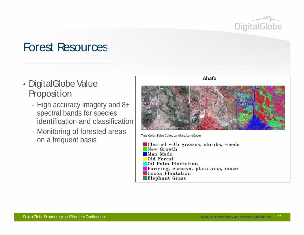
Forest ResourcesForest Resources
• DigitalGlobe Value Proposition- High accuracy imagery and 8+ - High accuracy imagery and 8+
spectral bands for species identification and classification
- Monitoring of forested areas - Monitoring of forested areas on a frequent basis
DigitalGlobe Proprietary and Business ConfidentialDigitalGlobe Proprietary and Business Confidential 22
Forestry Issues Addressed
• Forest Resources
Forestry Issues Addressed
• Forest Resources • Yearly Estimation of Timber/Paper/Palm Oil• Illicit Crop Identification and Monitoring
Disaster Relief Planning (Landslides and Forest Fires)• Disaster Relief Planning (Landslides and Forest Fires)
DigitalGlobe Proprietary and Business Confidential 23
Yearly Estimation of Timber/Paper/Palm Oil
• Who is the Customer?
Yearly Estimation of Timber/Paper/Palm Oil
• Who is the Customer?- State Forest Departments- UN-World Bank funded projects- Fire Management/Forestry Public Security Bureau- Fire Management/Forestry Public Security Bureau
• Customer Needs?- Incorrect inventory of timber/commercial wood grown in a region/country- Incorrect inventory of timber/commercial wood grown in a region/country- Illegal trading of timber due to inaccurate estimations of national production
capacity - National economies hampered by inaccurate estimates of timber production - National economies hampered by inaccurate estimates of timber production
capacity
DigitalGlobe Proprietary and Business Confidential 24
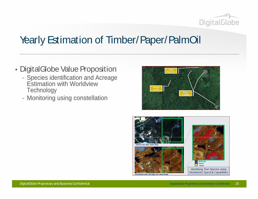
Yearly Estimation of Timber/Paper/PalmOilYearly Estimation of Timber/Paper/PalmOil
• DigitalGlobe Value Proposition- Species identification and Acreage
Estimation with Worldview TechnologyEstimation with Worldview Technology
- Monitoring using constellation
DigitalGlobe Proprietary and Business ConfidentialDigitalGlobe Proprietary and Business Confidential 25
Forestry Issues Addressed
• Forest Resources
Forestry Issues Addressed
• Forest Resources • Yearly Estimation of Timber/Paper/PalmOil• Illicit Crop Cultivation Amid Forests
Disaster Relief Planning (Landslides and Forest Fires)• Disaster Relief Planning (Landslides and Forest Fires)
DigitalGlobe Proprietary and Business Confidential 26

Illicit Crop Cultivation Amid Forests
• Customers
Illicit Crop Cultivation Amid Forests
• Customers- Counter Narcotics Departments- Military- National Security/Police- National Security/Police
• Customer Needs- Identify and eradicate where illegal crops are being grown- Identify and eradicate where illegal crops are being grown- Have forest regions secured to prevent innocent civilians from entering these
regions
DigitalGlobe Proprietary and Business Confidential 27
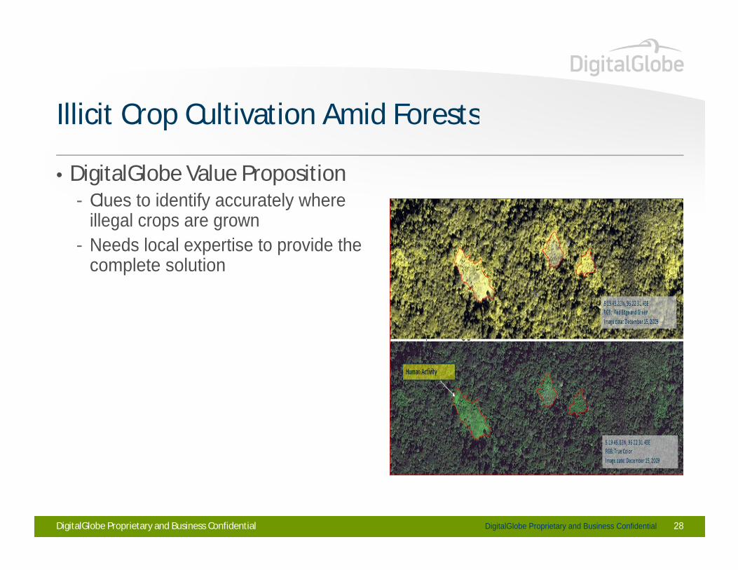
Illicit Crop Cultivation Amid ForestsIllicit Crop Cultivation Amid Forests
• DigitalGlobe Value Proposition• DigitalGlobe Value Proposition- Clues to identify accurately where
illegal crops are grown- Needs local expertise to provide the - Needs local expertise to provide the
complete solution
DigitalGlobe Proprietary and Business ConfidentialDigitalGlobe Proprietary and Business Confidential 28
Forestry Issues Addressed
• Forest Resources
Forestry Issues Addressed
• Forest Resources • Yearly Estimation of Timber/Paper/PalmOil• Illicit Crop Cultivation Amid Forests
Disaster Relief Planning (Landslides and Forest Fires)• Disaster Relief Planning (Landslides and Forest Fires)
DigitalGlobe Proprietary and Business Confidential 29
Disaster Relief Planning (Landslides and Forest Fires)
• Customers
Disaster Relief Planning (Landslides and Forest Fires)
• Customers- Information agencies for disaster prevention and reduction- State Forest Departments
• Customer Needs- Identify areas of constant flooding and landslides and highlight importance - Identify areas of constant flooding and landslides and highlight importance
of forests to anchor soil in place- Generate quick and accurate relief maps for forest fires, for rescue
operationsoperations- High spatial resolution to generate rescue routes with aid of local ground
information
DigitalGlobe Proprietary and Business Confidential 30
Disaster Relief Planning (Landslides and Forest
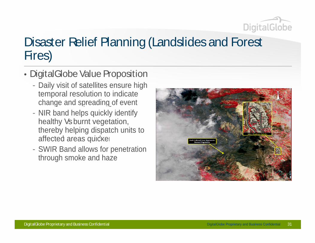
• DigitalGlobe Value Proposition
Disaster Relief Planning (Landslides and Forest Fires)• DigitalGlobe Value Proposition
- Daily visit of satellites ensure high temporal resolution to indicate change and spreading of eventchange and spreading of event
- NIR band helps quickly identify healthy Vsburnt vegetation, thereby helping dispatch units to affected areas quickeraffected areas quicker
- SWIR Band allows for penetration through smoke and haze
DigitalGlobe Proprietary and Business ConfidentialDigitalGlobe Proprietary and Business Confidential 31

Bannerghatta National Park - 2004Bannerghatta National Park - 2004
DigitalGlobe Proprietary and Business Confidential
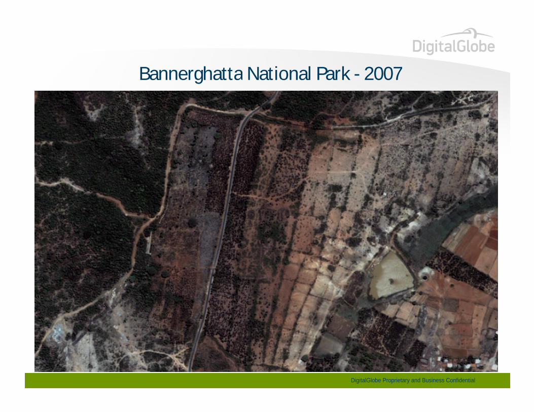
Bannerghatta National Park - 2007Bannerghatta National Park - 2007
DigitalGlobe Proprietary and Business Confidential

Bannerghatta National Park - 2011Bannerghatta National Park - 2011
DigitalGlobe Proprietary and Business Confidential
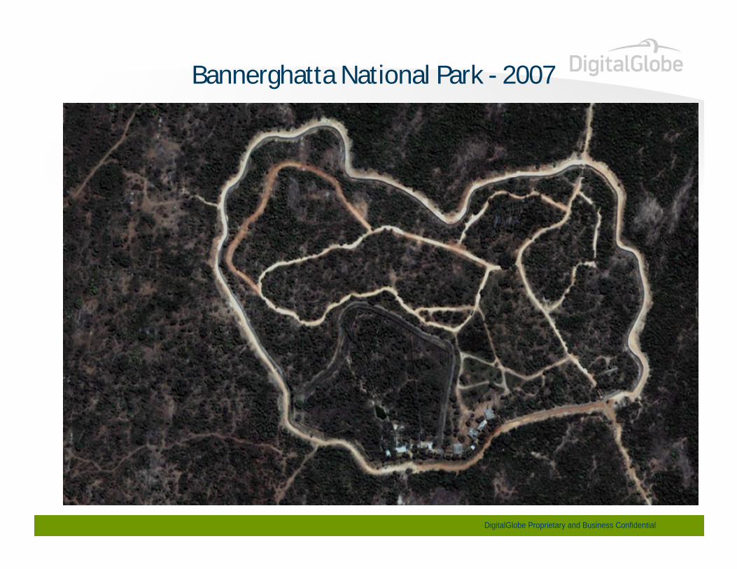
Bannerghatta National Park - 2007
DigitalGlobe Proprietary and Business Confidential
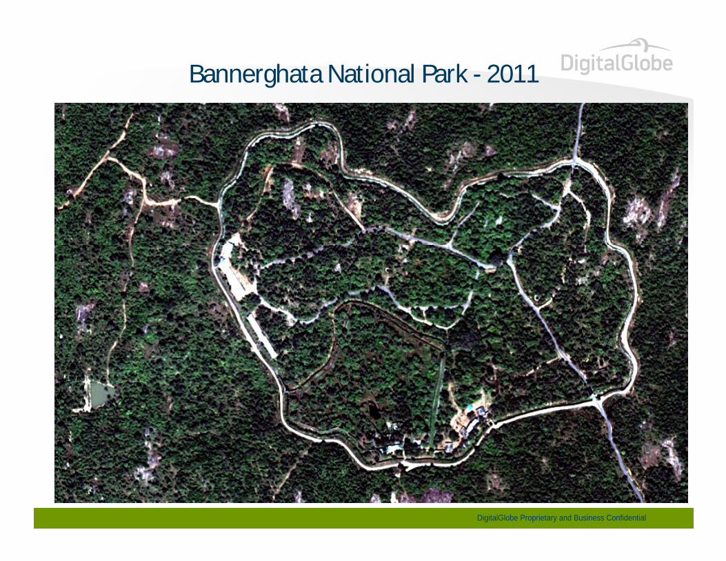
Bannerghata National Park - 2011
DigitalGlobe Proprietary and Business Confidential
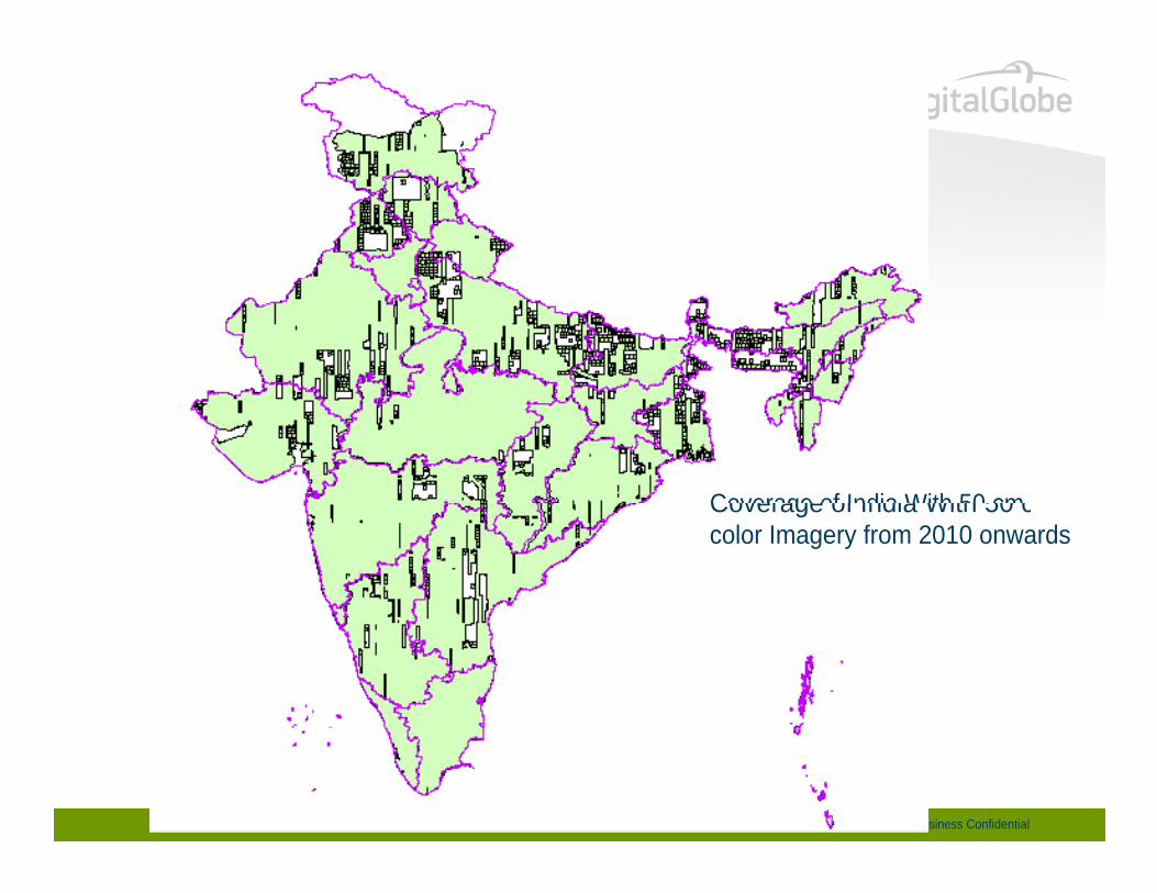
Coverage of India With 50 cm Coverage of India With 50 cm color Imagery from 2010 onwards
DigitalGlobe Proprietary and Business Confidential
DigitalGlobe Proprietary and Business Confidential 38


![Finale 2006 - [ ] - secult.ce.gov.br · PDF fileLAMENTOS De: Pixinguinha Arr:. Manoel Ferreira Lima & & & & & & & & & & & & & & &????? bb # # # # # # bb bb bb bb 10](https://static.fdocument.pub/doc/165x107/5a7991ed7f8b9a197e8cdd8a/finale-2006-secultcegovbr-lamentos-de-pixinguinha-arr-manoel-ferreira.jpg)