Millennial variabilityofratesofsea-level riseintheancient ...
15
Millennial variability of rates of sea-level rise in the ancient harbour of Naples (Italy, western Mediterranean Sea) Matteo Vacchi a * , Elda Russo Ermolli b , Christophe Morhange c,d , Maria R. Ruello b , Valentino Di Donato b , Mauro A. Di Vito e , Daniela Giampaola f , Vittoria Carsana f , Viviana Liuzza b , Aldo Cinque b , Giulia Boetto g , Pierre Poveda g , Giuliana Boenzi f , Nick Marriner h a Dipartimento di Scienze Della Terra, Università di Pisa, 56126 Pisa, Italy b Dipartimento di Scienze della Terra, dell’Ambiente e delle Risorse, Università di Napoli Federico II, 80126 Naples, Italy c Aix Marseille Université, CNRS, IRD, Coll France, CEREGE, 13545 Aix-en-Provence, France d The Leon Recanati Institute for Maritime Studies at the University of Haifa (RIMS), Haifa 31905, Israel e Istituto Nazionale di Geofisica e Vulcanologia, sezione di Napoli Osservatorio Vesuviano, 80124 Naples, Italy f Soprintendenza Archeologia, Belle arti e Paesaggio per il comune di Napoli, 80132 Naples, Italy g Aix Marseille Université, CNRS, CCJ, 13094 Aix-en-Provence, France h CNRS, ThéMA UMR 6049, Université de Bourgogne Franche-Comté, 32 rue Mégevand, Besançon Cedex, 25030, France *Corresponding author: e-mail address: [email protected] (M. Vacchi). (RECEIVED February 26, 2019; ACCEPTED August 19, 2019) Abstract We reconstructed the late Holocene relative sea-level (RSL) evolution of the ancient harbour of Naples, one of the largest coastal conurbations in the Mediterranean. We carried out multiproxy investigations, coupling archaeological evidence with biological indicators. Our data robustly constrain 2000 yr of non-monotonic changes in sea level, chiefly controlled by the complex volcano-tectonic processes that characterize the area. Between ∼200 BC and AD ∼0, a subsidence rate of more than ∼1.5 mm/yr enhanced the postglacial RSL rise, while negligible or moderate land uplift < ∼0.5 mm/yr triggered a RSL stabilization during the Roman period ( first five centuries AD). This stabilization was followed by a post-Roman enhancement of the sea-level rise when ground motion was negative, attested by a subsidence rate of ∼0.5 to ∼1 mm/yr. Our analysis seems to indicate very minor impacts of this nonmonotonic RSL evolution on the activities of the ancient har- bour of Naples, which peaked from the third century BC to the second century AD. After this period, the progressive silting of the harbour basin made it impossible to safely navigate within the basin, leading to the progressive decline of the harbour. Keywords: Geo-archeology; Sea-level changes; Ancient harbours; Naples; Volcano-tectonics; Mediterranean Sea; Parthenope-Neapolis INTRODUCTION Past records of coastal evolution represent a key tool to inter- pret the future modifications of littoral areas in the context of global change (e.g., Pirazzoli, 1997; Kemp et al., 2011). Within this scope, several recent studies have sought to recon- struct late Holocene (i.e., last 4000 yr) coastal changes along the global coastlines using a wide range of proxies (e.g., Barlow et al., 2013; Khan et al., 2015; Seeliger et al., 2017). In this article, we present the results of a geoarchaeo- logical survey revealing ∼4000 yr of relative sea-level (RSL) evolution in the ancient harbour of the Graeco-Roman town of Parthenope-Neapolis (Naples, western Mediterranean; Fig. 1A). This part of the Italian coast lies in a very complex geody- namic setting, and its Holocene geomorphological evolution has primarily been controlled by both tectonics and active volcanism (Fig. 1B, e.g., Milia et al., 2006; Ferranti et al., 2010; Aucelli et al., 2017b). The aim of this article is to better constrain the role of these factors in the area of Naples, one of the largest coastal conurbations in the Mediterranean. In par- ticular, we aimed to better quantify the timing and magnitude of land-level changes that significantly influenced the rates of RSL variation in the last four millennia. Many Mediterranean coastal cities have a long history, in some cases extending back thousands of years (e.g., Bini et al., 2018). For this reason, the development of methodological approaches adapted to interpretation of Cite this article: Vacchi, M. et al 2019. Millennial variability of rates of sea-level rise in the ancient harbour of Naples (Italy, western Mediterranean Sea). Quaternary Research 1–15. https://doi.org/10.1017/qua.2019.60 Quaternary Research Copyright © University of Washington. Published by Cambridge University Press, 2019. doi:10.1017/qua.2019.60 1 **C),---75#6(89B(7B(9*9(#) **C),8BB(D+5 0B-A"B5898 :(B# **C),---75#6(89B(7B(9 A,9()*5 8 2)5 )*9#5 .6"B*975(5 8 -*9A9B BA 1B, 5* ,',' )+6!97* *B *9 /5#6(89 /B(9 *9(#) B: +)9 5,5"56"9 5*
Transcript of Millennial variabilityofratesofsea-level riseintheancient ...
Millennial variability of rates of sea-level rise in the ancient harbour ofNaples (Italy, western Mediterranean Sea)
Matteo Vacchia* , Elda Russo Ermollib, ChristopheMorhangec,d, Maria R. Ruellob, Valentino Di Donatob, Mauro A. Di Vitoe,Daniela Giampaolaf, Vittoria Carsanaf, Viviana Liuzzab, Aldo Cinqueb, Giulia Boettog, Pierre Povedag, Giuliana Boenzif,Nick MarrinerhaDipartimento di Scienze Della Terra, Università di Pisa, 56126 Pisa, ItalybDipartimento di Scienze della Terra, dell’Ambiente e delle Risorse, Università di Napoli Federico II, 80126 Naples, ItalycAix Marseille Université, CNRS, IRD, Coll France, CEREGE, 13545 Aix-en-Provence, FrancedThe Leon Recanati Institute for Maritime Studies at the University of Haifa (RIMS), Haifa 31905, IsraeleIstituto Nazionale di Geofisica e Vulcanologia, sezione di Napoli Osservatorio Vesuviano, 80124 Naples, ItalyfSoprintendenza Archeologia, Belle arti e Paesaggio per il comune di Napoli, 80132 Naples, ItalygAix Marseille Université, CNRS, CCJ, 13094 Aix-en-Provence, FrancehCNRS, ThéMA UMR 6049, Université de Bourgogne Franche-Comté, 32 rue Mégevand, Besançon Cedex, 25030, France*Corresponding author: e-mail address: [email protected] (M. Vacchi).
(RECEIVED February 26, 2019; ACCEPTED August 19, 2019)
Abstract
We reconstructed the late Holocene relative sea-level (RSL) evolution of the ancient harbour of Naples, one of the largestcoastal conurbations in the Mediterranean. We carried out multiproxy investigations, coupling archaeological evidencewith biological indicators. Our data robustly constrain 2000 yr of non-monotonic changes in sea level, chiefly controlledby the complex volcano-tectonic processes that characterize the area. Between ∼200 BC and AD ∼0, a subsidence rateof more than∼1.5 mm/yr enhanced the postglacial RSL rise, while negligible or moderate land uplift <∼0.5 mm/yr triggereda RSL stabilization during the Roman period (first five centuries AD). This stabilization was followed by a post-Romanenhancement of the sea-level rise when ground motion was negative, attested by a subsidence rate of ∼0.5 to ∼1 mm/yr.Our analysis seems to indicate very minor impacts of this nonmonotonic RSL evolution on the activities of the ancient har-bour of Naples, which peaked from the third century BC to the second century AD. After this period, the progressive silting ofthe harbour basin made it impossible to safely navigate within the basin, leading to the progressive decline of the harbour.
Keywords: Geo-archeology; Sea-level changes; Ancient harbours; Naples; Volcano-tectonics; Mediterranean Sea;Parthenope-Neapolis
INTRODUCTION
Past records of coastal evolution represent a key tool to inter-pret the future modifications of littoral areas in the context ofglobal change (e.g., Pirazzoli, 1997; Kemp et al., 2011).Within this scope, several recent studies have sought to recon-struct late Holocene (i.e., last 4000 yr) coastal changes alongthe global coastlines using a wide range of proxies (e.g.,Barlow et al., 2013; Khan et al., 2015; Seeliger et al.,2017). In this article, we present the results of a geoarchaeo-logical survey revealing ∼4000 yr of relative sea-level (RSL)evolution in the ancient harbour of the Graeco-Roman town
of Parthenope-Neapolis (Naples, western Mediterranean;Fig. 1A).
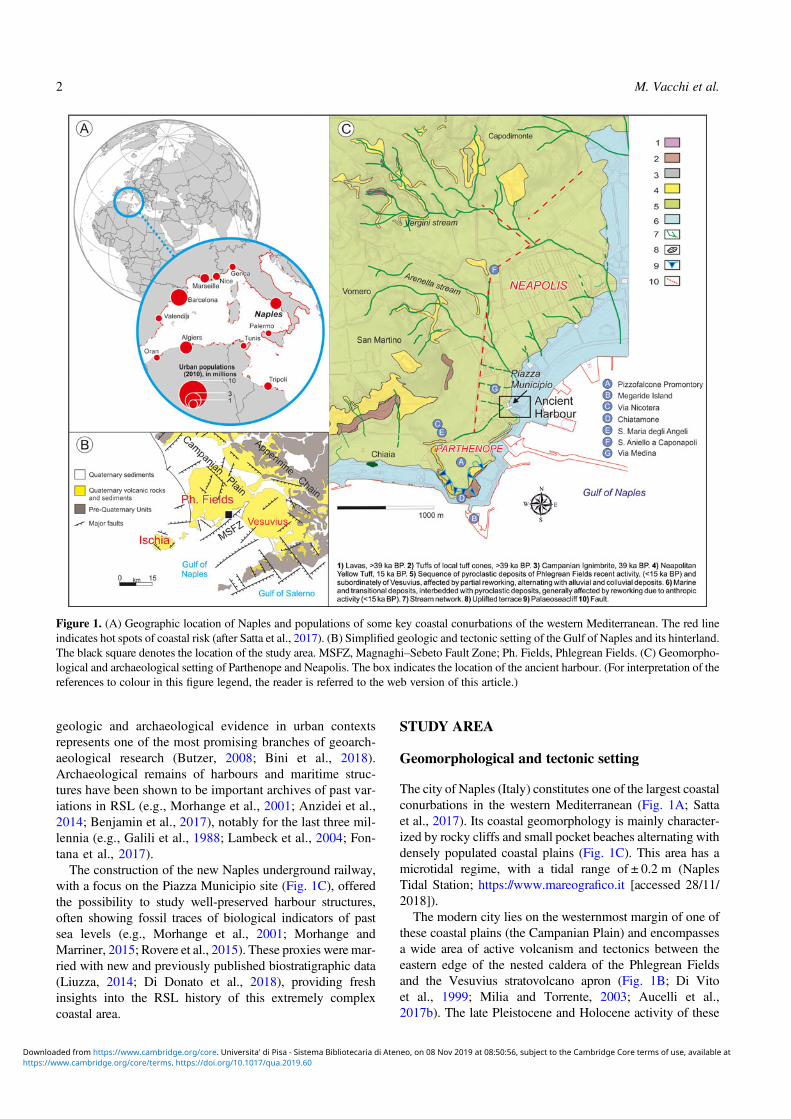
This part of the Italian coast lies in a very complex geody-namic setting, and its Holocene geomorphological evolutionhas primarily been controlled by both tectonics and activevolcanism (Fig. 1B, e.g., Milia et al., 2006; Ferranti et al.,2010; Aucelli et al., 2017b). The aim of this article is to betterconstrain the role of these factors in the area of Naples, one ofthe largest coastal conurbations in the Mediterranean. In par-ticular, we aimed to better quantify the timing and magnitudeof land-level changes that significantly influenced the rates ofRSL variation in the last four millennia.
Many Mediterranean coastal cities have a long history,in some cases extending back thousands of years (e.g.,Bini et al., 2018). For this reason, the development ofmethodological approaches adapted to interpretation of
Cite this article: Vacchi, M. et al 2019. Millennial variability of rates ofsea-level rise in the ancient harbour of Naples (Italy, western MediterraneanSea). Quaternary Research 1–15. https://doi.org/10.1017/qua.2019.60
Quaternary ResearchCopyright © University of Washington. Published by Cambridge University Press, 2019.doi:10.1017/qua.2019.60
1
C , 75 6 8 9 B 7B 9 9 C , 8B B D 50B A B5898 : B C , 75 6 8 9 B 7B 9 A 9 5 8 2 5 9 5 . 6 B 975 5 8 - 9A9B BA 1B 5 ,' ,' 6 97 B 9 /5 6 8 9 /B 9 9 B: 9 5 5 56 9 5
geologic and archaeological evidence in urban contextsrepresents one of the most promising branches of geoarch-aeological research (Butzer, 2008; Bini et al., 2018).Archaeological remains of harbours and maritime struc-tures have been shown to be important archives of past var-iations in RSL (e.g., Morhange et al., 2001; Anzidei et al.,2014; Benjamin et al., 2017), notably for the last three mil-lennia (e.g., Galili et al., 1988; Lambeck et al., 2004; Fon-tana et al., 2017).The construction of the new Naples underground railway,
with a focus on the Piazza Municipio site (Fig. 1C), offeredthe possibility to study well-preserved harbour structures,often showing fossil traces of biological indicators of pastsea levels (e.g., Morhange et al., 2001; Morhange andMarriner, 2015; Rovere et al., 2015). These proxies were mar-ried with new and previously published biostratigraphic data(Liuzza, 2014; Di Donato et al., 2018), providing freshinsights into the RSL history of this extremely complexcoastal area.
STUDY AREA
Geomorphological and tectonic setting
The city of Naples (Italy) constitutes one of the largest coastalconurbations in the western Mediterranean (Fig. 1A; Sattaet al., 2017). Its coastal geomorphology is mainly character-ized by rocky cliffs and small pocket beaches alternating withdensely populated coastal plains (Fig. 1C). This area has amicrotidal regime, with a tidal range of ± 0.2 m (NaplesTidal Station; https://www.mareografico.it [accessed 28/11/2018]).The modern city lies on the westernmost margin of one of
these coastal plains (the Campanian Plain) and encompassesa wide area of active volcanism and tectonics between theeastern edge of the nested caldera of the Phlegrean Fieldsand the Vesuvius stratovolcano apron (Fig. 1B; Di Vitoet al., 1999; Milia and Torrente, 2003; Aucelli et al.,2017b). The late Pleistocene and Holocene activity of these
Figure 1. (A) Geographic location of Naples and populations of some key coastal conurbations of the western Mediterranean. The red lineindicates hot spots of coastal risk (after Satta et al., 2017). (B) Simplified geologic and tectonic setting of the Gulf of Naples and its hinterland.The black square denotes the location of the study area. MSFZ, Magnaghi–Sebeto Fault Zone; Ph. Fields, Phlegrean Fields. (C) Geomorpho-logical and archaeological setting of Parthenope and Neapolis. The box indicates the location of the ancient harbour. (For interpretation of thereferences to colour in this figure legend, the reader is referred to the web version of this article.)
2 M. Vacchi et al.
C , 75 6 8 9 B 7B 9 9 C , 8B B D 50B A B5898 : B C , 75 6 8 9 B 7B 9 A 9 5 8 2 5 9 5 . 6 B 975 5 8 - 9A9B BA 1B 5 ,' ,' 6 97 B 9 /5 6 8 9 /B 9 9 B: 9 5 5 56 9 5
two volcanic complexes led to the deposition of thick tuffdeposits and sequences of pyroclastic fallout and density cur-rent deposits (Di Vito et al., 1999; Milia et al., 2006).The Campanian Plain is developed on top of a 3-km-thick
sedimentary sequence filling a Quaternary tectonic depres-sion known as the Campanian Plain Graben (Santangeloet al., 2017). This plain and its offshore extension have expe-rienced continuous subsidence during the entire Quaternary,at an average rate of ∼2 mm/yr (Santangelo et al., 2017).The morphology of the city has been significantly con-
trolled by late Quaternary volcanic activity, with a majorrole played by the Phlegrean Fields (e.g., Aiello andMarsella,2015; Aucelli et al., 2017b). The current landscape is theresult of the mantling of preexisting volcanic edifices by theNeapolitan Yellow Tuff (NYT; 15 ka; Deino et al., 2004),the collapse of the related caldera (Phlegrean Fields depres-sion), and, between 15 and 3.8 ka, of the explosive activityof at least 70 monogenetic volcanoes, which generated tuffcones, tuff rings, and widespread Plinian deposits (e.g., DiVito et al., 1999; Milia and Torrente, 2003).The intense volcano-tectonic activity also resulted in a
number of fault scarps (mainly southwest–northeast andnorthwest–southeast) that are widespread across the studyarea (e.g., Orsi et al., 2004; Cinque et al., 2011; Romanoet al., 2013; Fig. 1B), including within the Phlegrean Fieldscaldera, in the Gulf of Naples, and the Campanian Plain(Di Vito et al., 1999; Bruno et al., 2003; Cinque et al.,2011). A major fault zone (the Magnaghi–Sebeto FaultZone [MSFZ], Fig. 1B; Bruno et al., 2003), occurs in themid- to northern portion of the gulf with alternating north-east–southwest and east–west trending segments. TheMSFZ bounds the subsiding Sebeto Plain, where subsidencerates of 1.5–2 mm/yr have been estimated for the lateHolocene (Cinque et al., 2011; Aucelli et al., 2019).
Archaeological setting
In the Naples area, evidence for human occupation dates backto the late Neolithic and the Eneolithic period (Giampaolaand Boenzi, 2013), as indicated by a sequence of plowzones associated with traces of human occupation, whichwas found intercalated in volcanic deposits attributed to thePigna S. Nicola (9.2–9.5 ka) and Agnano-Monte Spina(4.5–4.6 ka) eruptions (Di Vito et al., 1999; Smith et al.,2011).There is evidence for the occupation of a large coastal area
west of Pizzofalcone promontory, on the Castel Nuovoheights and at the margin of the Neapolis plateau (Fig. 1C)in the Early Bronze Age (twenty-first century to twentiethcentury BC, 4.0 to 3.9 ka). Despite the interruption causedby the Pomici di Avellino eruption (twentieth century BC),which largely concerned the Naples area, evidence of a per-sistent coastal occupation was also found in the MiddleBronze Age (seventeenth century to fourteenth century BC,3.6 to 3.3ka) and, at some sites, until the Late Bronze Age(Giampaola and Boenzi, 2013; Romano et al., 2013; DiVito et al., 2019). However, the most important coastal
occupation of the area started in the eighth century to seventhcentury BC (2.6–2.7 ka), when Greek colonists founded anepineion (harbour) named Parthenope. This was placed atthe foot of San Martino hill, on the promontory of Pizzofal-cone and on the Megaride island (Fig. 1C): the only archae-ological evidence for this ancient centre is the necropolis ofvia Nicotera and the ceramic material of Chiatamone andthe S. Maria degli Angeli dump (end of the eighth centuryto fifth century BC; 2.7–2.4 ka; Cinquantaquattro, 2015;Giampaola, 2017; Fig. 1C). Parthenope survived as a minorcentre named Palaepolis (old-polis) until the fourth–thirdcenturies BC (2.3–2.2 ka). At the end of the sixth to thebeginning of fifth century BC (∼2.5 ka), a new-polis, Neap-olis, was founded at the eastern edge of Parthenope (e.g.,D’Agostino and Giampaola, 2005) on a gently sloping androunded plateau (Fig. 1C). Neapolis developed continuouslyfrom the end of the sixth century BC (∼2.5 ka) to the end ofthe fifth century AD (∼1.5 ka).
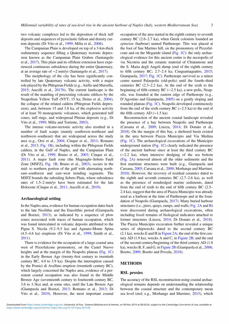
Reconstruction of the ancient coastal landscape revealedthe presence of a bay between Neapolis and Parthenope(Carsana et al., 2009; Liuzza, 2014; Di Donato et al.,2018). On the margin of this bay, a sheltered basin existedin the area between Piazza Municipio and Via Medina(Fig. 1C). The archaeological excavations of the Municipiounderground station (Fig. 1C) clearly indicated the presenceof the ancient harbour since at least the third century BC(∼2.2 ka), when intensive dredging of the sea bottom(Fig. 2A) removed almost all the older sediments and thefirst maritime structures were built (e.g., Giampaola andCarsana, 2005; Carsana et al., 2009; Morhange and Marriner,2010). However, the recovery of residual ceramics dated tothe eighth and seventh centuries BC (2.7–2.6 ka), as wellas the presence of nondredged marine sediments, datedfrom the end of sixth to the end of fifth century BC (2.5–2.4 ka), suggest that the area of Piazza Municipio was alreadyused as a harbour at the time of Parthenope and at the foun-dation of Neapolis (Giampaola, 2017). Many buried harbourstructures (i.e., piers, quays, ramps, and walls; Fig. 2A and B)were discovered during archaeological excavations, oftenincluding fossil remains of biological indicators attached toformer structures (Liuzza, 2014; Di Donato et al., 2018).The Piazza Municipio excavation further revealed a uniqueseries of shipwrecks dated to the second century BC(2.1 ka), wrecks E and H in Figure 2A; the end of the first cen-tury AD (1.9 ka), wrecks A and C, in Figure 2B; and the endof the second century/beginning of the third century AD (1.8ka), wrecks B, F, and G, in Figure 2B (Giampaola et al., 2006;Boetto, 2009; Boetto and Poveda, 2018).
METHODS
RSL proxies
The accuracy of the RSL reconstruction using coastal archae-ological remains depends on understanding the relationshipbetween the coastal structure and the contemporary meansea level (msl; e.g., Morhange and Marriner, 2015), which
Millennial variability of rates of sea-level rise in the ancient harbour of Naples (Italy, western Mediterranean Sea) 3
C , 75 6 8 9 B 7B 9 9 C , 8B B D 50B A B5898 : B C , 75 6 8 9 B 7B 9 A 9 5 8 2 5 9 5 . 6 B 975 5 8 - 9A9B BA 1B 5 ,' ,' 6 97 B 9 /5 6 8 9 /B 9 9 B: 9 5 5 56 9 5
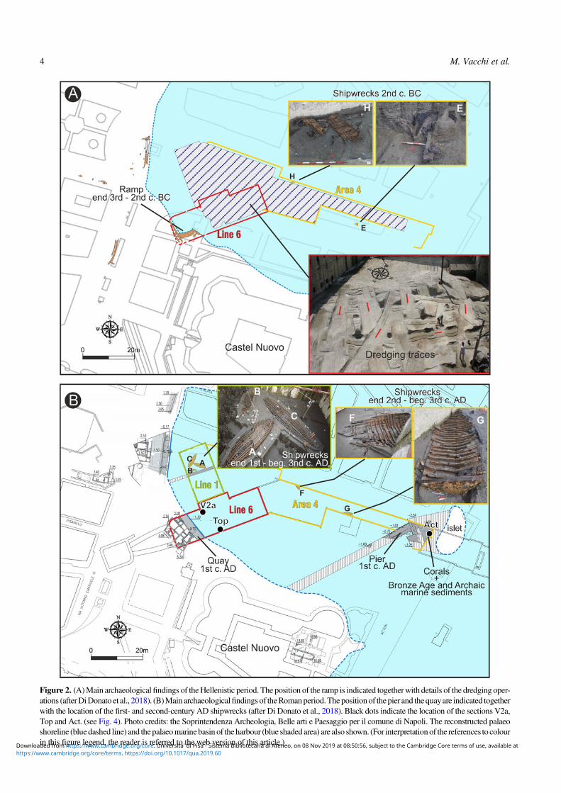
Figure 2. (A)Main archaeologicalfindings of theHellenistic period. The position of the ramp is indicated togetherwith details of the dredging oper-ations (afterDiDonato et al., 2018). (B)Main archaeologicalfindingsof theRomanperiod.Thepositionof thepier and thequayare indicated togetherwith the location of the first- and second-century AD shipwrecks (after Di Donato et al., 2018). Black dots indicate the location of the sections V2a,Top and Act. (see Fig. 4). Photo credits: the Soprintendenza Archeologia, Belle arti e Paesaggio per il comune di Napoli. The reconstructed palaeoshoreline (bluedashed line) and the palaeomarinebasinof theharbour (blue shadedarea) are also shown. (For interpretationof the references to colourin this figure legend, the reader is referred to the web version of this article.)
4 M. Vacchi et al.
C , 75 6 8 9 B 7B 9 9 C , 8B B D 50B A B5898 : B C , 75 6 8 9 B 7B 9 A 9 5 8 2 5 9 5 . 6 B 975 5 8 - 9A9B BA 1B 5 ,' ,' 6 97 B 9 /5 6 8 9 /B 9 9 B: 9 5 5 56 9 5
significantly improves when fossil remains of attached bio-logical indicators are present (e.g., Laborel and Laborel-Deguen, 1994; Morhange et al., 2001; Morhange andMarriner, 2015). Several studies have demonstrated that a pre-cise analysis of the biological zone (cf. Laborel and Laborel-Deguen, 1994) found on archaeological structures may leadto a very precise assessment (up to ± 0.1 m) of the formerRSL (e.g., Morhange et al., 2001, 2013; Morhange andMarriner, 2015).In this study, we analysed the biological assemblages
found on harbour structures. These assemblages are com-posed of encrusting species such as vermetids and Ostreaspp. The upper limit of the living zone of these species delin-eates the biological mean sea level (bmsl; Morhange andMarriner, 2015; Rovere et al., 2015). The bmsl is not a perfecthorizontal line but is naturally warped, even over short dis-tances, because of local variations in hydrodynamics andmorphology (Vacchi et al., 2016). However, in the microtidalMediterranean setting, bmsl occupies the lower part of thetidal range (i.e., from mean low water [MLW] to the msl;Laborel and Laborel-Deguen, 1994; Rovere et al., 2015).For this reason, these biological markers are often used to pro-duce very accurate RSL index points (i.e., a point that con-strains the palaeo-RSL in space and time; van de Plassche,1982), notably in the Mediterranean Sea (Morhange et al.,2001, 2013; Vacchi et al., 2018).Following Shennan et al. (2015), we estimated the
palaeo-RSL position according to the following equation:
RSLi = Ai − RWLi
where A is the elevation of the sample i, and RWL is the ref-erence water level (i.e., the midpoint of the indicative range ofthe sample i; see Table 1).
Apart from the sediments and structures of the Hellenisticand Roman harbour, marine sands overlying the tufaceousbedrock and related to ancient marine bottoms were identifiedbetween 5.1 and 3.7 m below msl (Giampaola, 2018). Thesesediments were investigated by means of an integratedapproach including granulometric and palaeontological analy-ses, which allowed us to define the depositional environments.In particular, the palaeoecological interpretation of fossilassemblages was based on the present ecology of the identi-fied mollusk taxa. A more detailed description of these meth-odologies is provided in Di Donato et al. (2018). The marinebiofacies do not represent an accurate RSL proxy becausethey can only constrain the RSL above a datum. However,they can be transformed into marine limiting points to helpprobe changes in RSL through time and to estimate the direc-tions and the rates of these changes (Shennan et al., 2015).
Chronological constraints
The age of both RSL index and limiting points is constrainedby the archaeological dating of both the harbour structures(Boetto et al., 2010; Giampaola, 2017) and the sedimentaryunits (Di Donato et al., 2018). The latter is based on thearchaeological content (mainly pottery) of the marine/lagoonsequences found in the harbour basin. This pottery is oftenwell preserved and comprises goods and ship equipmentlost during loading and unloading operations in the harbour,in addition to waste from the surrounding urban area (Di
Table 1. Index and limiting points used to reconstruct the relative sea-level (RSL) evolution of the ancient harbour of Naples. Thestratigraphic age is given by the archaeological content of the deposit. The calibration of the 14C age of the Balanophyllia sp. samples wasperformed using the∆R value of 69 ± 40 (Siani et al., 2000). IR, indicative range;MHW,mean high water; MLW,mean lowwater; msl, meansea level.
EvidenceType ofdating
Age cal(BC/AD)
Elevation(m msl)
Elevationerror (m) IR
RSL(m)
Error(m) Type
Balanophyllia sp.(DSH7335_SH)
Radiocarbon age(3990 ± 31 14C yr BP)
1961 ± 157 BC −4.60 0.05 Below msl > −4.6 0.05 Marine limitingpoint
Balanophyllia sp.(Poz-3066)
Radiocarbon age(3890 ± 35 14C yr BP)
1818 ± 150 BC −4.50 0.05 Below msl > −4.5 0.05 Marine limitingpoint
Marine deposit Stratigraphic age 1450 ± 150 BC −4.25 0.05 Below msl > −4.25 0.05 Marine limitingpoint
Marine deposit Stratigraphic age 450 ± 50 BC −3.70 0.05 Below msl > −4.5 0.05 Marine limitingpoint
Ostrea sp. on Hellenisticramp
Stratigraphic age andramp age
150 ± 50 BC −2.10 0.05 MLW tomsl
−2.0 0.1 Index point
Erosional mark on theAugustean pier
Harbour age AD 50 ± 50 −1.60 0.1 MHW toMLW
−1.6 0.2 Index point
Upper limit of Ostrea sp.and vermetids
Stratigraphic age AD 425 ± 25 −1.60 0.05 MLW tomsl
−1.5 0.1 Index point
Beachface deposit Stratigraphic age AD 550 ± 50 −1.30 0.1 Above msl < −1.3 0.1 Terrestriallimiting point
Upper limit of Ostrea sp. Stratigraphic age AD 1250 ± 50 −0.70 0.05 MLW tomsl
−0.6 0.1 Index point
Millennial variability of rates of sea-level rise in the ancient harbour of Naples (Italy, western Mediterranean Sea) 5
C , 75 6 8 9 B 7B 9 9 C , 8B B D 50B A B5898 : B C , 75 6 8 9 B 7B 9 A 9 5 8 2 5 9 5 . 6 B 975 5 8 - 9A9B BA 1B 5 ,' ,' 6 97 B 9 /5 6 8 9 /B 9 9 B: 9 5 5 56 9 5
Donato et al., 2018). The chronological error associated withthis kind of material ranges between 50 and 100 yr.In order to improve the chronology, we acquired two new
14C dates on in situ fossil corals (Balanophyllia spp.) found atthe base of the stratigraphic sequence. These corals were inliving position on the tufaceous bedrock. The samples werecalibrated using CALIB 7.1 (Stuiver et al., 2019) and theMarine13 calibration curve (Reimer et al., 2013) with a ∆Rof 69 ± 40 (Siani et al., 2000). All vertical measurementswere undertaken using a Leica DGPS (differential GPS) rel-ative to the current msl with a precision of 0.05 m.
Isostatic and tectonic contributions to the RSLrecord
For the late Holocene period (i.e., last 4.0 ka), the ice-equivalent meltwater is either zero or minimal (Milne et al.,2005; Church et al., 2008). Therefore, changes observed inRSL are dominated by vertical land movements because ofglacio- and hydro-isostatic adjustment (GIA). In tectonicallyactive areas, the GIA related land-level changes can be accen-tuated or counterbalanced by ground movements (e.g., Anzi-dei et al., 2014; Vacchi et al., 2014; Kolaiti et al., 2017)In order to better quantify these vertical components, we
compared the reconstructed RSL record with the followingGIA predictions available for the Gulf of Naples: (1) theICE-5 G VM2 (Peltier, 2004) GIA prediction computed inVacchi et al. (2016) using the “sea-level equation” solverSELEN (Spada and Stocchi, 2007); and (2) theK33_j1b_WS9_6 GIA prediction computed in the Gulf ofNaples by Lambeck et al. (2011). This comparison allowedus to factor-out the GIA-related land-level changes from thereconstructed RSL history in order to assess the role of tec-tonic contributions for different historical periods.
RESULTS
The archaeological findings (Fig. 3) coupled with the analysisof sedimentary sequences and microfaunal remains (Lines 1and 6 and Area 4, Fig. 2A and B; Fig. 4) have yielded evi-dence for∼4000 yr of RSL evolution at the Piazza Municipiosite. The results are presented in chronological order from theoldest to the most recent.
Bronze Age period
The rocky seafloor outcrops at the base of the sedimentarysequence of the harbour basin. It is composed of yellowtuff and is widely colonized by benthic species includingbivalves, corals, and serpulids. At 4.6 and 4.5 m below msl,two corals (Balanophyllia sp.) were found in living positionon rocky outcrops (Fig. 4). This coral, widespread in theMed-iterranean, is typical of the upper infralittoral zone (Goffredoet al., 2004). The two samples yielded very coherent ages of1961 ± 157 and 1818 ± 150 cal yr BC (approximately twenti-eth century to approximately nineteenth century BC, the final
phase of the Early Bronze Age; Table 1). Marine sedimentsoverlie the basal rocky seafloor until 4.25 m below msl.These comprise coarse-to-medium, poorly sorted sands char-acterised by a slight fining upward trend. Benthic foraminif-era assemblages are mostly represented by taxa that arepresently widespread in infralittoral vegetated seafloors ofthe Gulf of Naples (Sgarrella and Moncharmont-Zei, 1993)such as Cibicides lobatulus, Elphidium crispum, Elphidiummacellum, Rosalina spp., and, among the miliolids,Quinque-loculina pseudobuchiana, Miliolinella spp., and Siphona-perta spp. Vermetids are also abundant in the washresidues. The abundance of archaeological material allowedthese infralittoral units to be attributed to the Middle BronzeAge (MBA 1–2 and 3, sixteenth to fourteenth centuries BC;Table 1).
Greek period
A further marine unit overlies the MBA sediments up to3.7 m below msl. This unit, similar to the MBA unit ingrain size and faunal assemblages, showed an upwards coars-ening trend. The dating of the archaeological material foundin this unit yielded Archaic ages (end of the sixth century toend of the fifth century BC; Table 1). This implies an∼800 yrgap (from 1300 to 500 BC) in sedimentation in this marineunit (Fig. 4). The causes of this hiatus are unclear (see Discus-sion section) but could be ascribed to drift erosion.At about 2 m below msl, the first large archaeological har-
bour structure was observed. This is a gently sloping surfacethat is ∼12 m long and made of squared blocks (Figs. 2A and3A). The top and the bottom of this structure are placed at1.53 m and at 2.25 m below msl, respectively. This structure,composed of large tuff blocks, lies on a sandy bottom con-taining marine-shell remains, Posidonia oceanica seagrass,and ceramic fragments (Fig. 3A). The archaeological excava-tion indicates that this structure was in use during the Helle-nistic period (end of the third century to second centuryBC; Table 1) and was likely used as a ramp or slipway. Themaritime characteristics of this structure are further attestedby fossil remains of Ostrea spp. found at its seaward end(Fig. 3A). The upper limit of the marine shell encrustationwas measured at 2.1 m ± 0.05 m below msl and is buried bylate third-century BC sands. The remains of two Hellenisticshipwrecks were also found lying on the seabed of the bay(Fig. 2A).
Roman period
In the first century AD, several large harbour structures werebuilt to serve the rapidly expanding Roman Naples. Theseinfrastructures were intended to provide a better-protectedcove in order to improve accessibility and navigability. Atthat time, the seafloor reached maximal depths of 5 to 6 m,as testified by evidence for dredging of the tufaceous substrate(NYT). A small islet at the cove entrance (Fig. 2B) was usedas a base for a large pier (Fig. 3B) that was probably built toprotect the internal part of the harbour from the southern
6 M. Vacchi et al.
C , 75 6 8 9 B 7B 9 9 C , 8B B D 50B A B5898 : B C , 75 6 8 9 B 7B 9 A 9 5 8 2 5 9 5 . 6 B 975 5 8 - 9A9B BA 1B 5 ,' ,' 6 97 B 9 /5 6 8 9 /B 9 9 B: 9 5 5 56 9 5
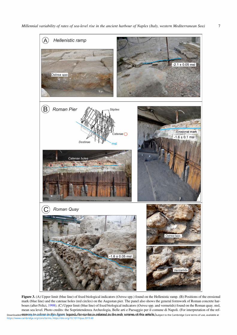
Figure 3. (A) Upper limit (blue line) of fixed biological indicators (Ostrea spp.) found on the Hellenistic ramp. (B) Positions of the erosionalmark (blue line) and the catenae holes (red circles) on the Augustan pier. The panel also shows the general formwork of Roman concrete har-bours (after Felici, 1998). (C) Upper limit (blue line) of fixed biological indicators (Ostrea spp. and vermetids) found on the Roman quay. msl,mean sea level. Photo credits: the Soprintendenza Archeologia, Belle arti e Paesaggio per il comune di Napoli. (For interpretation of the ref-erences to colour in this figure legend, the reader is referred to the web version of this article.)
Millennial variability of rates of sea-level rise in the ancient harbour of Naples (Italy, western Mediterranean Sea) 7
C , 75 6 8 9 B 7B 9 9 C , 8B B D 50B A B5898 : B C , 75 6 8 9 B 7B 9 A 9 5 8 2 5 9 5 . 6 B 975 5 8 - 9A9B BA 1B 5 ,' ,' 6 97 B 9 /5 6 8 9 /B 9 9 B: 9 5 5 56 9 5
swell. In the western part of the cove, a perfectly preservedquay was also found (Figs. 2B and 3C).The low-energy harbour environment has recorded the pro-
gressive silting of the basin. The marine stratigraphy (Fig. 4),precisely dated using the archaeological content (mainly pot-tery), yielded ages ranging from the Augustan (end of thefirst century BC to beginning of the first century AD) to thelate Roman periods (fifth century AD; Di Donato et al.,2018). Additional chronological constraints were providedby five shipwrecks found in the harbour basin (Boetto et al.,2010, Boetto and Poveda, 2018). They were dated from theend of the first to the beginning of the third century AD(Fig. 2B).
The concrete pier
On the southeastern side of the harbour basin, the remains ofan impressive pier, ∼360 m2 in area and composed of twoarms, was observed (Fig. 2B). The pier was built using awooden frame filled with opus caementicium (hydrauliccement; Brandon et al., 2014). Its top was measured from0.7 to 1.15 m below msl. The lower part of the pier, at 4 mbelow msl, shows the preserved wooden planks (stipites) ofthe formwork wedged in sandy sediments dated to the secondhalf of the first century BC (Table 1).In the concrete infilling, above the stipites, holes testify to
the presence of catenae (Fig. 3B). Above each of the stipites,holes hosting the catenae are observed (Fig. 3B). Catenae arehorizontal wooden beams that were used to contain the exter-nal thrusts during harbour construction and, notably, duringthe consolidation phase of the hydraulic cement (Felici,1998; Brandon et al., 2014). About 10 cm below the catenaeholes, a long and continuous erosional mark can be observed
along the whole length of the pier. It has a generally horizon-tal shape and was measured at 1.6 ± 0.1 m below msl(Fig. 3B).On the western side of the harbour basin, a large quay,
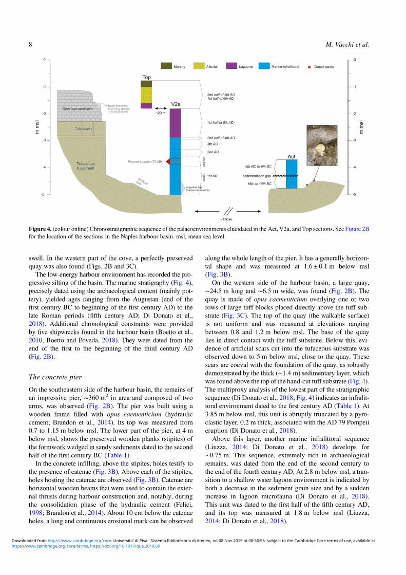
∼24.5 m long and ∼6.5 m wide, was found (Fig. 2B). Thequay is made of opus caementicium overlying one or tworows of large tuff blocks placed directly above the tuff sub-strate (Fig. 3C). The top of the quay (the walkable surface)is not uniform and was measured at elevations rangingbetween 0.8 and 1.2 m below msl. The base of the quaylies in direct contact with the tuff substrate. Below this, evi-dence of artificial scars cut into the tufaceous substrate wasobserved down to 5 m below msl, close to the quay. Thesescars are coeval with the foundation of the quay, as robustlydemonstrated by the thick (∼1.4 m) sedimentary layer, whichwas found above the top of the hand-cut tuff substrate (Fig. 4).The multiproxy analysis of the lowest part of the stratigraphicsequence (Di Donato et al., 2018; Fig. 4) indicates an infralit-toral environment dated to the first century AD (Table 1). At3.85 m below msl, this unit is abruptly truncated by a pyro-clastic layer, 0.2 m thick, associated with the AD 79 Pompeiieruption (Di Donato et al., 2018).Above this layer, another marine infralittoral sequence
(Liuzza, 2014; Di Donato et al., 2018) develops for∼0.75 m. This sequence, extremely rich in archaeologicalremains, was dated from the end of the second century tothe end of the fourth century AD. At 2.8 m below msl, a tran-sition to a shallow water lagoon environment is indicated byboth a decrease in the sediment grain size and by a suddenincrease in lagoon microfauna (Di Donato et al., 2018).This unit was dated to the first half of the fifth century AD,and its top was measured at 1.8 m below msl (Liuzza,2014; Di Donato et al., 2018).
Figure 4. (colour online) Chronostratigraphic sequence of the palaeoenvironments elucidated in the Act, V2a, and Top sections. See Figure 2Bfor the location of the sections in the Naples harbour basin. msl, mean sea level.
8 M. Vacchi et al.
C , 75 6 8 9 B 7B 9 9 C , 8B B D 50B A B5898 : B C , 75 6 8 9 B 7B 9 A 9 5 8 2 5 9 5 . 6 B 975 5 8 - 9A9B BA 1B 5 ,' ,' 6 97 B 9 /5 6 8 9 /B 9 9 B: 9 5 5 56 9 5
On the quay structure, a significant population of encrust-ing fossil species (mainlyOstrea and vermetids; Fig. 3C) wasobserved (Liuzza, 2014). They are widespread on the archae-ological structure, and their upper limit (Fig. 3C) was mea-sured at 1.60 ± 0.05 m below msl. The colonization by thisattached marine organism was interrupted by the progressivesilting of the quay area, before being sealed by sedimentsdated to the first half of the fifth century AD (Table 1).
Late Roman and medieval periods
The Roman harbour basin shows evidence for progressivesilting throughout antiquity. During the excavation, thequay structure was found covered by a sandy to gravellybeach deposit rich in marine-shell debris (mainly Loripeslucinalis, Paphia aurea, Bittium reticulatum, Tapes decussa-tus, and Cerithium vulgatum) mixed with abundant vegetalremains (e.g., nutshells, almonds, and seeds; Liuzza, 2014).Furthermore, this deposit is full of anthropogenic remainssuch as ceramics and glass fragments, pieces of mosaic,and traces of iron and lead (Liuzza, 2014). In some cases,the sandy sediments show plane parallel bedding or a foresetstratification. This palaeobeach was archeologically dated tothe end of the fifth century to the beginning of the sixth cen-tury AD (Table 1) and was found at elevations of 1 ± 0.2 mbelow msl (Liuzza, 2014). A further indicator of thelate-Roman evolution of the harbour basin is the presence,in Line 6 of the excavation area (Fig. 2B), of a beachfacedeposit at 1.3 ± 0.2 m below msl. This deposit, dated to thesixth century AD (Table 1), is bordered by small junipertrees (Juniperus spp.) found in living position (Barone,M.R., University of Naples, personal communication) andextending for about 13 m.Finally, on the top portion of the Roman pier (Fig. 2B),
there is evidence of biological encrustations (mainly Ostreasp.) up to 0.7 m below msl. These encrustations continuedto colonize the structure after the end of the operationalperiod. They were sealed by sediments dating to the thirteenthcentury to fourteenth century AD (Table 1).
DISCUSSION
New constraints on the RSL history of the ancientharbour of Naples
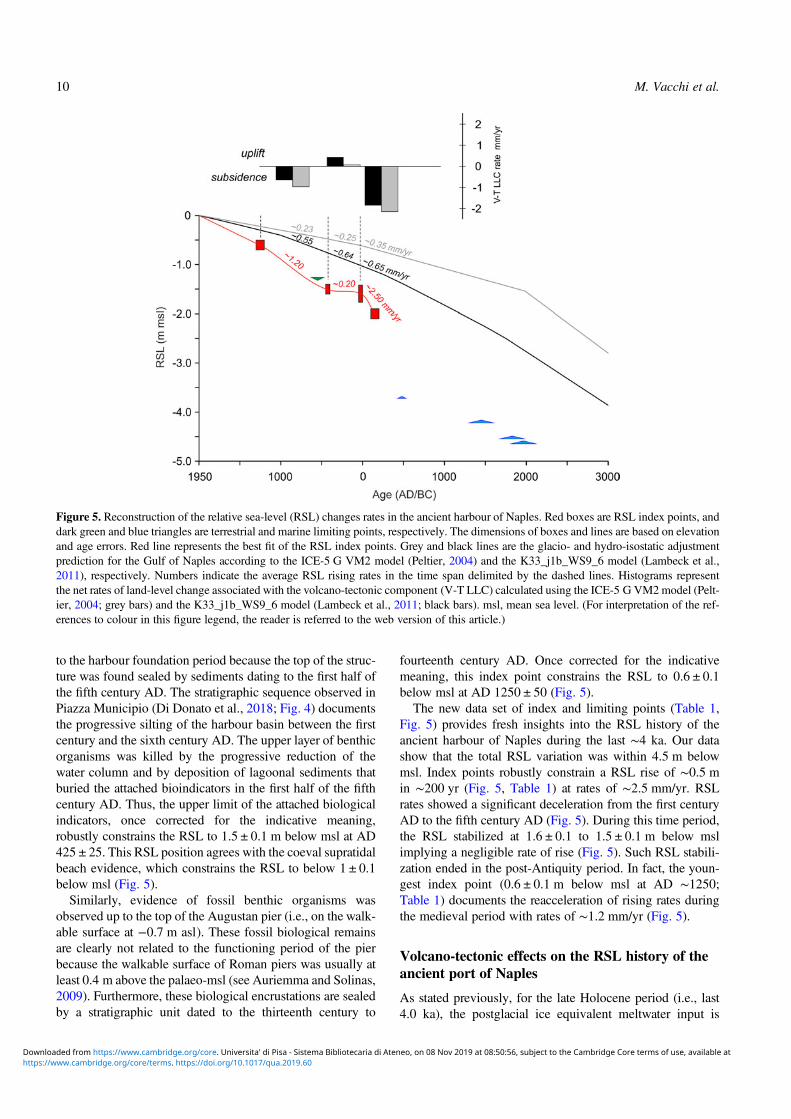
The multiproxy analysis of sediments from the ancient Gulfof Naples provides new constraints on the RSL evolution ofthe area (Fig. 5). Between ∼2000 and ∼500 BC, the RSL isloosely constrained by the sole presence of marine limitingpoints. The oldest data, represented by the fossil corals, con-strain the RSL position to above ∼4.5 m below msl at ∼1800BC (Fig. 5).The benthic assemblages of the overlying infralittoral
marine sediments testify to the occurrence of seafloors withPosidonia oceanica meadows throughout the Bronze andArchaic Age periods. The living range of this endemic
Mediterranean seagrass is wide (0 to 40 m below msl; Vacchiet al., 2017), and therefore, these marine sediments only con-strain the RSL above 4.25 m below msl at ∼1400 BC andabove 3.7 m below msl at ∼500 BC (Fig. 5). It is worth notingthe absence of sedimentation between the fourteenth centuryand the sixth century BC. The causes of this ∼800 yr hiatusare unclear. A possible explanation may be related to the posi-tion of this sedimentary sequence, which is located in the mostexternal part of the basin, near the small rocky islet (Fig. 2B).Changes in the nearshore hydrodynamics, triggered by theperiod of increased Mediterranean storminess recordedbetween ∼1600 and ∼600 BC (e.g., Sabatier et al., 2012;Marriner et al., 2017), may have produced increased erosionin the outer part of the basin. However, this hypothesis requiresmore detailed investigations to understand the environmentalsetting of the basin before the foundation of the harbour.
The oldest RSL index point is provided by the biologicalencrustation found on the Hellenistic ramp. In low-energyharbour settings, the upper limit of Ostrea sp. occurs in thelower part of the intertidal zone (MLW to msl, Table 1;Laborel and Laborel-Deguen, 1994; Morhange et al., 2013;Morhange and Marriner, 2015). Once corrected for the indic-ative meaning, it precisely constrains the RSL position to2.0 ± 0.1 m below msl during the Hellenistic period(150 ± 50 BC; Table 1, Fig. 5).
The majority of the harbour structures are dated to theRoman period. In particular, the quay and the pier are bothattributed to the Augustan period (end first century BC -beginning first century AD; Giampaola 2017, 2018). Thepresence of catenae holes ∼0.1 m above well-developed ero-sional marks, observed along the whole length of the pier,provides insights into the RSL position at the time of the har-bour foundation. According to Vitruvius (“de Architectura,”∼20 BC), the catenae (Fig. 3B) were placed slightly above thesea surface (Felici, 1998; Oleson, 1988; Mattei et al., 2018).Thus, these features suggest an RSL position of 1.6 ± 0.2 mbelow msl during the first half of the first century AD (AD25 ± 25; Table 1, Fig. 5).
Furthermore, the thick layer of harbour deposits foundabove the artificially cut basement in front of the quay(Fig. 4) offers additional insights into the RSL position tothe first century AD. These marine sediments are sealed atthe top (3.65 m below msl) by volcanic ash and marineremains attributed to the Plinian eruption of AD 79. Insum, this represents the harbour seafloor in the second partof the first century AD. The larger sailing ship found in theharbour (Napoli A, Fig. 2B) was 14.25 m long. If we addthis ship draft (∼2 m) to the palaeoseafloor, we obtain avalue of ∼1.65 m below msl. The ship draught alone cannotbe considered a robust proxy for RSL reconstruction (e.g.,Morhange and Marriner, 2015). However, the reconstructedsea-level agrees with the RSL position (1.6 ± 0.2 m belowmsl) indicated by the erosional mark on the pier.
The RSL insights that can be extracted from the analysis ofthe harbour structures are not limited to the first century AD.On the quay, several traces of encrusting fossil organismswere observed (Fig. 3C). Their upper limit cannot be related
Millennial variability of rates of sea-level rise in the ancient harbour of Naples (Italy, western Mediterranean Sea) 9
C , 75 6 8 9 B 7B 9 9 C , 8B B D 50B A B5898 : B C , 75 6 8 9 B 7B 9 A 9 5 8 2 5 9 5 . 6 B 975 5 8 - 9A9B BA 1B 5 ,' ,' 6 97 B 9 /5 6 8 9 /B 9 9 B: 9 5 5 56 9 5
to the harbour foundation period because the top of the struc-ture was found sealed by sediments dating to the first half ofthe fifth century AD. The stratigraphic sequence observed inPiazza Municipio (Di Donato et al., 2018; Fig. 4) documentsthe progressive silting of the harbour basin between the firstcentury and the sixth century AD. The upper layer of benthicorganisms was killed by the progressive reduction of thewater column and by deposition of lagoonal sediments thatburied the attached bioindicators in the first half of the fifthcentury AD. Thus, the upper limit of the attached biologicalindicators, once corrected for the indicative meaning,robustly constrains the RSL to 1.5 ± 0.1 m below msl at AD425 ± 25. This RSL position agrees with the coeval supratidalbeach evidence, which constrains the RSL to below 1 ± 0.1below msl (Fig. 5).Similarly, evidence of fossil benthic organisms was
observed up to the top of the Augustan pier (i.e., on the walk-able surface at −0.7 m asl). These fossil biological remainsare clearly not related to the functioning period of the pierbecause the walkable surface of Roman piers was usually atleast 0.4 m above the palaeo-msl (see Auriemma and Solinas,2009). Furthermore, these biological encrustations are sealedby a stratigraphic unit dated to the thirteenth century to
fourteenth century AD. Once corrected for the indicativemeaning, this index point constrains the RSL to 0.6 ± 0.1below msl at AD 1250 ± 50 (Fig. 5).The new data set of index and limiting points (Table 1,
Fig. 5) provides fresh insights into the RSL history of theancient harbour of Naples during the last ∼4 ka. Our datashow that the total RSL variation was within 4.5 m belowmsl. Index points robustly constrain a RSL rise of ∼0.5 min ∼200 yr (Fig. 5, Table 1) at rates of ∼2.5 mm/yr. RSLrates showed a significant deceleration from the first centuryAD to the fifth century AD (Fig. 5). During this time period,the RSL stabilized at 1.6 ± 0.1 to 1.5 ± 0.1 m below mslimplying a negligible rate of rise (Fig. 5). Such RSL stabili-zation ended in the post-Antiquity period. In fact, the youn-gest index point (0.6 ± 0.1 m below msl at AD ∼1250;Table 1) documents the reacceleration of rising rates duringthe medieval period with rates of ∼1.2 mm/yr (Fig. 5).
Volcano-tectonic effects on the RSL history of theancient port of Naples
As stated previously, for the late Holocene period (i.e., last4.0 ka), the postglacial ice equivalent meltwater input is
Figure 5. Reconstruction of the relative sea-level (RSL) changes rates in the ancient harbour of Naples. Red boxes are RSL index points, anddark green and blue triangles are terrestrial and marine limiting points, respectively. The dimensions of boxes and lines are based on elevationand age errors. Red line represents the best fit of the RSL index points. Grey and black lines are the glacio- and hydro-isostatic adjustmentprediction for the Gulf of Naples according to the ICE-5 G VM2 model (Peltier, 2004) and the K33_j1b_WS9_6 model (Lambeck et al.,2011), respectively. Numbers indicate the average RSL rising rates in the time span delimited by the dashed lines. Histograms representthe net rates of land-level change associated with the volcano-tectonic component (V-T LLC) calculated using the ICE-5 G VM2model (Pelt-ier, 2004; grey bars) and the K33_j1b_WS9_6 model (Lambeck et al., 2011; black bars). msl, mean sea level. (For interpretation of the ref-erences to colour in this figure legend, the reader is referred to the web version of this article.)
10 M. Vacchi et al.
C , 75 6 8 9 B 7B 9 9 C , 8B B D 50B A B5898 : B C , 75 6 8 9 B 7B 9 A 9 5 8 2 5 9 5 . 6 B 975 5 8 - 9A9B BA 1B 5 ,' ,' 6 97 B 9 /5 6 8 9 /B 9 9 B: 9 5 5 56 9 5
minor (Milne et al., 2005; Khan et al., 2015). Moreover, oursuite of RSL index points comprises mostly uncompressiblematerial, rendering the effects of compaction negligible.For these reasons, any change observed in our RSL recordis the sum of vertical land movements because of GIA andvolcano-tectonics (Ferranti et al., 2010; Cinque et al., 2011;Aucelli et al., 2016). According to the available geophysicalmodels for the Gulf of Naples (e.g., Lambeck et al., 2011;Vacchi et al., 2016; Roy and Peltier, 2018), the GIA contribu-tion should not exceed ∼1.1 m for the last ∼2 ka and ∼0.4 mfor the last ∼1 ka. All the RSL index points from the ancientport are placed significantly below both GIA model predic-tions (Fig. 5), suggesting a general subsidence trend duringthe last two millennia. This is not surprising because a dom-inant subsidence trend is reported as the major driver of lateHolocene coastal modification around much of the Gulf ofNaples (e.g., Cinque et al., 2011; Romano et al., 2013;Aucelli et al., 2017b). However, variability in the RSL risingrates (Fig. 5) was observed at least in the last∼2.2 kawhen theRSL evolution is robustly constrained by index points. Thisvariability is controlled by the interplay between volcanicactivity of both Phlegrean Fields and the Somma-Vesuvius(Aiello et al., 2001; Milia and Torrente, 2003; Morhangeet al., 2006; Aucelli et al., 2017a, 2018b) and the late Quater-nary activity of the MSFZ (Fig. 1B; Cinque et al., 2011),which resulted in a variable spatial pattern of late Holoceneland-level changes in the different parts of the gulf (Aucelliet al., 2016, 2017b; Mattei et al., 2018).In order to better quantify the volcano-tectonic component
of land-level changes in the area of Piazza Municipio, we fac-tored out the GIA contribution predicted by the two availablegeophysical models for the Gulf of Naples (see Methods sec-tion; Fig. 5). This analysis showed that a period of negativeland-level occurred between 150 ± 50 BC and AD 50 ± 50with rates between ∼2.15 and ∼1.85 mm/yr (Fig. 5). On thecontrary, land-level changes were negligible or slightly posi-tive (< ∼0.5 mm/yr) during the period between AD 50 ± 50and AD 425 ± 25. This triggered a phase of RSL stabilization(Fig. 5) where RSL rose by∼0.2 mm/yr, which is comparableto the rate predicted by ICE-5 GVM2 and slower than the ratepredicted by K33_j1b_WS9_6 (Fig. 5). After AD 425 ± 25,land-level changes were once again negative with subsidencerates ranging between ∼0.65 and ∼1 mm/yr (Fig. 5).These multiple cycles of uplift and subsidence have
already been reported in the coastal areas located near thePhlegrean Fields, in the northern part of the gulf (Fig. 1B;Cinque et al., 1997; Morhange et al., 2006; Aucelli et al.,2018a, 2018b). Along the Naples seafront (central-northernpart of the gulf; Fig. 1B), a mean subsidence rate of 1 mm/yr was estimated by Cinque et al. (2011). This dominant sub-siding trend was, however, not linear in space or time. Cinqueet al. (2011), and subsequently Romano et al. (2013), arguedthat minor episodes of uplift or accelerated subsidence relatedto the volcano-tectonic phenomena of the Phlegrean Fieldsdistrict are superimposed on the general subsidence rates.Our data support the hypothesis of a period of positive landuplift, which triggered a phase of RSL stabilization between
AD ∼0 and ∼450, which interrupts the general trend of RSLrise exceeding 2 mm/yr in the pre-Augustan period. Thisperiod of land uplift also counterbalanced the GIA-drivenRSL rise predicted in this time span (Fig. 4). However, no fur-ther evidence for RSL stabilization between the first and fifthcenturies AD has been reported in the Gulf of Naples. Bycontrast, the increase in rates of sea-level rise between thelate Roman to medieval periods is consistent with a majorphase of negative bradyseism (i.e., gradual subsidence) inthe Phlegrean Fields (Fig. 1B; Cinque et al., 1997; Morhangeet al., 2006; Di Vito et al., 2016), which triggered increasedsubsidence in the area of Chiaia (Fig. 1C) between the fifthand sixth centuries AD (Romano et al., 2013). Our dataseem to indicate that this increase in subsidence also affectedthe Piazza Municipio area.
These results further confirm the spatial complexity of RSLhistories inside the Gulf of Naples, where variability in land-level changes associated with volcano-tectonics played adominant role in controlling the RSL evolution during thelast four millennia. The causes of the Roman RSL decelera-tion are unclear. Positive land-level changes were most likelydriven by a period of positive bradyseism (i.e., gradualground movement caused by the filling of the undergroundcaldera) and/or by uplifting trends of the MSFZ footwall,which offset the general subsidence trend of the Gulf ofNaples.
Impacts of RSL changes on the evolution of theharbour water column
The RSL stability observed between the first and the fifthcenturies AD had significant implications for the use of theharbour during the Roman period. Silting problems insidethe basin, probably related to increased sedimentation, aredocumented from the Hellenistic period until the second cen-tury AD (Di Donato et al., 2018), as testified by widespreadevidence of dredging (Fig. 2A).
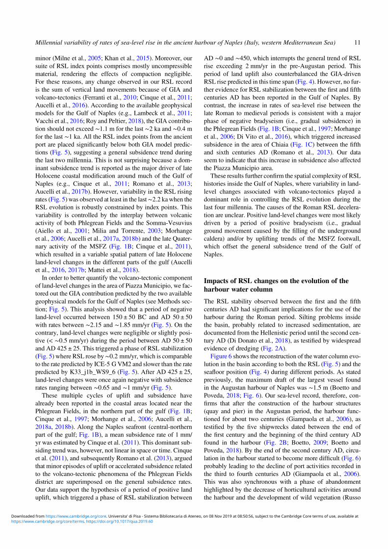
Figure 6 shows the reconstruction of the water column evo-lution in the basin according to both the RSL (Fig. 5) and theseafloor position (Fig. 4) during different periods. As statedpreviously, the maximum draft of the largest vessel foundin the Augustan harbour of Naples was ∼1.5 m (Boetto andPoveda, 2018; Fig. 6). Our sea-level record, therefore, con-firms that after the construction of the harbour structures(quay and pier) in the Augustan period, the harbour func-tioned for about two centuries (Giampaola et al., 2006), astestified by the five shipwrecks dated between the end ofthe first century and the beginning of the third century ADfound in the harbour (Fig. 2B; Boetto, 2009; Boetto andPoveda, 2018). By the end of the second century AD, circu-lation in the harbour started to become more difficult (Fig. 6)probably leading to the decline of port activities recorded inthe third to fourth centuries AD (Giampaola et al., 2006).This was also synchronous with a phase of abandonmenthighlighted by the decrease of horticultural activities aroundthe harbour and the development of wild vegetation (Russo
Millennial variability of rates of sea-level rise in the ancient harbour of Naples (Italy, western Mediterranean Sea) 11
C , 75 6 8 9 B 7B 9 9 C , 8B B D 50B A B5898 : B C , 75 6 8 9 B 7B 9 A 9 5 8 2 5 9 5 . 6 B 975 5 8 - 9A9B BA 1B 5 ,' ,' 6 97 B 9 /5 6 8 9 /B 9 9 B: 9 5 5 56 9 5
Ermolli et al., 2014). The sea-level stabilization in the firstfive centuries AD seems to have had minimal impacts onthe harbour sedimentation. In fact, we observed great vari-ability in the silting rates of the harbour despite the negligibleRSL variation during the whole period. This variability islargely controlled by other factors such as deposition ofhuman waste during the harbour apex (Di Donato et al.,2018) and the important sedimentary input linked to theAD 79 eruption and its subsequent reworking. Minimal tracesof dredging activity following the eruption were found infront of the quay (Di Donato et al., 2018). However, thesesporadic dredging scars cannot account for the suddendecrease in the rates of RSL rise observed from the end ofthe first century AD, which are probably of natural origin.No evidence of dredging activity was found after this period,further corroborating the progressive decline of harbour activ-ities after the second century AD. Harbour sedimentationrates reincreased significantly only after the transition froma marine infratidal to a lagoonal environment.
CONCLUSIONS
A multiproxy geoarchaeological investigation allowed us toreconstruct the millennial sea-level evolution in the ancientharbour of Naples, one of the most important Mediterraneancities. In this area, previous geoarchaeological investigationsmainly focused on the RSL histories of the Roman to medi-eval period. Here, we were able to robustly constrain theRSL evolution since the Hellenistic period (end of the thirdcentury to second century BC). Since this time, RSL rose
with average rates of∼2 mm/yr showing a nonmonotonic pat-tern mostly controlled by the area’s complex volcano-tectonicsetting. Increased negative land-level changes triggered arapid RSL rise (∼2.5 to ∼2.0 mm/yr) in the first two centuriesBC and in the post-Antiquity period (i.e., since the fifth cen-tury AD). This general trend of negative land-level changeswas interrupted for five centuries (AD 50 ± 50 to 425 ± 25)when a significant deceleration of the RSL rising rates(∼0.2 mm/yr) was observed. The causes of this stabilizationof the RSL position are most likely related to a positive bra-dyseism period in the Phlegrean Fields area, even if futureinvestigations are required to better constrain the role of theMSFZ in controlling the sea-level evolution of this denselypopulated area of the Mediterranean coastline.Our results further confirm the extremely complex pattern
of land-level changes in the Gulf of Naples where detailedspatiotemporal investigations into the variability of groundmotion rates associated with volcano-tectonics represent akey tool to better quantify the current coastal hazard.
Acknowledgements
This article is dedicated to the memory of our friend and colleaguePaola Romano who significantly investigated the coastal evolutionof Naples in recent years. MV is funded by the Rita Levi Montalciniprogramme of the Italian Ministry of University and Research(MIUR). CM and MV thank the Labex OT-Med (ANR-11-LABX-0061) and the A*MIDEX project (ANR-11-IDEX-0001-02). Our study is a contribution to the MOPP-Medflood(INQUA CMP 1603P) and HOLSEA (INQUA CMP 1601P) pro-jects. We also extend our gratitude to the PALSEA 2 (PAGES/
Figure 6. (colour online) Sedimentation rates and evolution of the water column in the harbour basin. The progressive decrease in harbour draftdepths is also denoted. Typical draft of the boat found in the harbour is based on Boetto and Poveda (2018). msl, mean sea level.
12 M. Vacchi et al.
C , 75 6 8 9 B 7B 9 9 C , 8B B D 50B A B5898 : B C , 75 6 8 9 B 7B 9 A 9 5 8 2 5 9 5 . 6 B 975 5 8 - 9A9B BA 1B 5 ,' ,' 6 97 B 9 /5 6 8 9 /B 9 9 B: 9 5 5 56 9 5
INQUA/WUN working group) and IGCP Project 639 communitiesfor fruitful discussions during the workshops. We warmly thankCarlo Nike Bianchi and Carla Morri (DISTAV, University ofGenova, Italy) who helped us with the identification of the fossilbenthic species. Finally, we thank two anonymous reviewers andthe associate editor Barbara Mauz who greatly improved the earlyversion of the manuscript.
REFERENCES
Aiello, G., Budillon, V., Cristofalo, G., d’Argenio, B., DeAlteriis, G., De Lauro, M., Ferraro, L., et al., 2001. Marine geol-ogy and morphobathymetry in the Bay of Naples (south-easternTyrrhenian sea, Italy). In: Faranda, F.M., Guglielmo, L.,Spezi, G. (Eds.), Mediterranean Ecosystems. Springer, Milan,Italy, pp. 1–8.
Aiello, G., Marsella, E., 2015. Interactions between Late Quaternaryvolcanic and sedimentary processes in the Naples Bay, southernTyrrhenian sea. Italian Journal of Geosciences 134, 367–382.
Anzidei, M., Lambeck, K., Antonioli, F., Furlani, S.,Mastronuzzi, G., Serpelloni, E., Vannucci, G., 2014. Coastalstructure, sea-level changes and vertical motion of the land inthe Mediterranean. Geological Society, London, Special Publica-tions 388, 453–479.
Aucelli, P.P., Brancaccio, L. and Cinque, A., 2017a. Vesuvius andCampi Flegrei: volcanic history, landforms and impact on settle-ments. In: Soldati, M., Marchetti, M. (Eds.), Landscapes andLandforms of Italy. Springer, Cham, Switzerland, pp. 389–398.
Aucelli, P., Cinque, A., Giordano, F., Mattei, G., 2016. A geoarch-aeological survey of the marine extension of the Roman archaeo-logical site Villa del Pezzolo, Vico Equense, on the SorrentoPeninsula, Italy. Geoarchaeology 31, 244–252.
Aucelli, P.P., Cinque, A.,Mattei, G., Pappone, G., 2017b. Late Holo-cene landscape evolution of the Gulf of Naples (Italy) inferred fromgeoarchaeological data. Journal of Maps 13, 300–310.
Aucelli, P., Cinque, A., Mattei, G., Pappone, G., Rizzo, A., 2019.Studying relative sea level change and correlative adaptation ofcoastal structures on submerged Roman time ruins nearby Naples(southern Italy). Quaternary International 501B, 328–348.
Aucelli, P., Cinque, A., Mattei, G., Pappone, G., Stefanile, M.,2018a. Coastal landscape evolution of Naples (Southern Italy)since the Roman period from archaeological and geomorpholog-ical data at Palazzo degli Spiriti site. Quaternary International483, 23–38.
Aucelli, P.P., Cinque, A., Mattei, G., Pappone, G., Stefanile, M.,2018b. First results on the coastal changes related to local sealevel variations along the Puteoli sector (Campi Flegrei, Italy)during the historical times. Alpine and Mediterranean Quater-nary 31, 13–16.
Auriemma, R., Solinas, E., 2009. Archaeological remains as sealevel change markers: a review. Quaternary International 206,134–146.
Barlow, N.L., Shennan, I., Long, A.J., Gehrels, W.R., Saher, M.H.,Woodroffe, S.A., Hillier, C., 2013. Salt marshes as late Holocenetide gauges. Global and Planetary Change 106, 90–110.
Benjamin, J., Rovere, A., Fontana, A., Furlani, S., Vacchi, M.,Inglis, R.H., Galili, E., et al., 2017. Late Quaternary sea-levelchanges and early human societies in the central and eastern Med-iterranean Basin: an interdisciplinary review.Quaternary Interna-tional 449, 29–57.
Bini, M., Fabiani, F., Pappalardo, M., Schuldenrein, J., 2018. Urbangeoarchaeology in the Mediterranean basin. Geoarchaeology 33,3–12.
Boetto, G., 2009. New archaeological evidence of the Horeia-typevessels: the Roman Napoli C shipwreck from Naples (Italy) andthe boats of Toulon (France) compared. In: Bockius, R. (Ed.),Proceedings of the 11th International Symposium of Boat andShip Archaeology. Verlag des römisch-germanischen Zentralmu-seums, Mainz, Germany, pp. 289–296.
Boetto, G., Carsana, V., Giampaola, D., 2010. I relitti di Napoli e illoro contesto portuale. Archeologia, storia, etnologia navale: attidel I convegno nazionale, Cesenatico, Museo della Marineria,4–5 aprile 2008. Edipuglia, Bari, Italy, pp. 115–22.
Boetto, G., Poveda, P., 2018. Napoli A, un voilier abandonné dansle port de Neapolis à la fin du Ier siècle : architecture, fonction,restitution et espace de navigation. In: Boetto, G., Rieth, E.(Eds). De re navali: Pérégrination nautiques entre Méditerranéeet océan Indien. Mélanges en l’honneur de Patrice Pomey(Archaeonautica, 20). CNRS éditions, Paris, pp. 19–56.
Brandon, C.J., Hohlfelder, R.L., Jackson,M.D., Oleson, J.P., 2014.Building for Eternity: The History and Technology of RomanConcrete Engineering in the Sea. Oxbow Books, Oxford, UK.
Bruno, P.P.G., Rapolla, A., Di Fiore, V., 2003. Structural setting ofthe Bay of Naples (Italy) seismic reflection data: implications forCampanian volcanism. Tectonophysics 372, 193–213.
Butzer, K.W., 2008. Challenges for a cross‐disciplinary geoarch-aeology: the intersection between environmental history andgeomorphology. Geomorphology 101, 402–411.
Carsana, V., Febbraro, S., Giampaola, D., Guastaferro, C., Irollo, G.,Ruello, M.R., 2009. Evoluzione del paesaggio costiero traParthenopee Neapolis. Méditerranée: Revue géographique despays méditerranéens/Journal of Mediterranean Geography 112,14–22.
Church, J.A.,White, N.J., Aarup, T.,Wilson,W.S.,Woodworth, P.L.,Domingues, C.M., Hunter, J.R., Lambeck, K., 2008. Understand-ing global sea levels: past, present and future. SustainabilityScience 3, 9–22.
Cinquantaquattro, T.E., 2015. L’attività archeologica della Soprin-tendenza Speciale di Napoli e Pompei. In: La Magna Grecia daPirro ad Annibale, Atti del LII Convegno di Studi sulla MagnaGrecia, Taranto 27–30 settembre 2012. Istituto per la storia el’archeologia della Magna Grecia, Taranto, Italy, pp. 865–908.
Cinque, A., Aucelli, P.P.C., Brancaccio, L., Mele, R., Milia, A.,Robustelli, G., Romano, P., et al., 1997. Volcanism, tectonicsand recent geomorphological change in the Bay of Napoli. Sup-plementi Geografia Fisica Dinamica Quaternaria 3, 123–141.
Cinque, A., Irollo, G., Romano, P., Ruello, M.R., Amato, L.,Giampaola, D., 2011. Ground movements and sea level changesin urban areas: 5000 years of geological and archaeological recordfrom Naples (southern Italy).Quaternary International 232, 45–55.
D’Agostino, B., Giampaola, D., 2005. Osservazioni storiche earcheologiche sulla fondazione di Neapolis. Noctes Campanae:studi di storia antica e archeologia dell’Italia pre-romana e romanain memoria di Martin W. Frederiksen. Luciano, Naples, Italy,pp. 63–72.
Deino, A.L., Orsi, G., de Vita, S., Piochi, M., 2004. The age of theNeapolitan Yellow Tuff caldera-forming eruption (Campi Flegreicaldera–Italy) assessed by 40 Ar/39 Ar dating method. Journal ofVolcanology and Geothermal Research 133, 157–170.
Di Donato, V., Ruello, M.R., Liuzza, V., Carsana, V.,Giampaola, D., Di Vito, M.A., Morhange, C., Cinque, A.,
Millennial variability of rates of sea-level rise in the ancient harbour of Naples (Italy, western Mediterranean Sea) 13
C , 75 6 8 9 B 7B 9 9 C , 8B B D 50B A B5898 : B C , 75 6 8 9 B 7B 9 A 9 5 8 2 5 9 5 . 6 B 975 5 8 - 9A9B BA 1B 5 ,' ,' 6 97 B 9 /5 6 8 9 /B 9 9 B: 9 5 5 56 9 5
Russo Ermolli, E., 2018. Development and decline of the ancientharbor of Neapolis. Geoarchaeology 33, 542–557.
Di Vito, M.A., Acocella, V., Aiello, G., Barra, D., Battaglia, M.,Carandente, A., Del Gaudio, C., et al., 2016. Magma transfer atCampi Flegrei caldera (Italy) before the 1538 AD eruption. Scien-tific Reports 6, 32245.
Di Vito, M.A., Isaia, R., Orsi, G., Southon, J.D., De Vita, S.,d’Antonio, M., Pappalardo, L., Piochi, M., 1999. Volcanismand deformation since 12,000 years at the Campi Flegrei caldera(Italy). Journal of Volcanology and Geothermal Research 91,221–246.
Di Vito, M.A., Talamo, P., de Vita, S., Rucco, I., Zanchetta, G.,Cesarano, M., 2019. Dynamics and effects of the VesuviusPomici di Avellino Plinian eruption and related phenomena onthe Bronze Age landscape of Campania region (southern Italy).Quaternary International 499B, 231–244.
Felici, E., 1998. La ricerca sui porti romani in cementizio: metodi eobiettivi. In: Volpe, G. (Ed.), Archeologia subacquea – comeopera l’archeologo sott’acqua. Storie dalle acque. VIII Ciclo dilezioni sulla Ricerca applicata in Archeologia (Certosa diPontignano 1996). Edizioni all’Insegna del Giglio, Florence,Italy, pp. 275–340.
Ferranti, L., Antonioli, F., Anzidei, M., Monaco, C., Stocchi, P.,2010. The timescale and spatial extent of vertical tectonicmotions in Italy: insights from relative sea-level changes studies.Journal of the Virtual Explorer 36, 30.
Fontana, A., Vinci, G., Tasca, G., Mozzi, P., Vacchi, M., Bivi, G.,Salvador, S., et al., 2017. Lagoonal settlements and relative sealevel during Bronze Age in northern Adriatic: geoarchaeologicalevidence and paleogeographic constraints. Quaternary Interna-tional 439, 17–36.
Galili, E., Weinstein-Evron, M., Ronen, A., 1988. Holocene sea-level changes based on submerged archaeological sites off thenorthern Carmel coast in Israel. Quaternary Research 29, 36–42.
Giampaola, D., 2017. Parthenope, Neapolis e il suo porto. In:Osanna, M., Rescigno, C. (Eds.), Pompei e i Greci. Electa,Milan, Italy, pp. 207–213.
Giampaola, D., 2018. Da Palepoli a Neapolis: lo strutturarsi delfronte costiero. In: LVIII Convegno Internazionale di Studisulla Magna Grecia: La Magna Grecia nel Mediterraneo in etàarcaica e classica. Forme, mobilità, interazioni, Taranto, 27–30settembre 2018. Istituto per la storia e l’archeologia dellaMagna Grecia, Taranto, Italy,
Giampaola, D., Boenzi, G., 2013. Interazione tra attività vulcanica evita dell’uomo: evidenze archeologiche nell’area urbana diNapoli. In: Di Vito, M.A., de Vita, S. (Eds.), Compendio dellelezioni Scuola estiva AIQUA 2013. Miscellanea INGV No. 18.INGV, Naples, Italy, pp. 38–44
Giampaola, D., Carsana, V., 2005. Neapolis. Le nuove scoperte: lacittà, il porto e le macchine. In: Lo Sardo, E. (Ed.), Eureka! ilgenio degli antichi, catalogo della mostra, Museo ArcheologicoNazionale di Napoli, 11 luglio 2005–9 gennaio 2006. Electa,Naples, Italy, pp. 116–122.
Giampaola, D., Carsana, V., Boetto, G., Crema, F., Florio, C.,Panza, D., Pizzo, B., et al., 2006. La scoperta del porto di “Neap-olis”: dalla ricostruzione topografica allo scavo e al recupero deirelitti. Archaeologia Maritima Mediterranea: An InternationalJournal on Underwater Archaeology 2, 47–91.
Goffredo, S., Mezzomonaco, L., Zaccanti, F., 2004, Genetic differ-entiation among populations of theMediterranean hermaphroditicbrooding coral Balanophyllia europaea (Scleractinia: Dendro-phylliidae). Marine Biology 6, 1075–1083.
Kemp, A.C., Horton, B.P., Donnelly, J.P., Mann, M.E.,Vermeer, M., Rahmstorf, S., 2011. Climate related sea-level var-iations over the past two millennia. Proceedings of the NationalAcademy of Sciences of the United States of America 108,11017–11022.
Khan, N.S., Ashe, E., Shaw, T.A., Vacchi, M., Walker, J.,Peltier, W.R., Kopp, R.E., Horton, B.P., 2015. Holocene relativesea-level changes from near-, intermediate-, and far-field loca-tions. Current Climate Change Reports 1, 247–262.
Kolaiti, E., Papadopoulos, G.A., Morhange, C., Vacchi, M.,Triantafyllou, I., Mourtzas, N. D., 2017. Palaeoenvironmentalevolution of the ancient harbor of Lechaion (Corinth Gulf,Greece): were changes driven by human impacts and gradualcoastal processes or catastrophic tsunamis? Marine Geology392, 105–121.
Laborel, J., Laborel-Deguen, F., 1994. Biological indicators ofrelative sea-level variations and of co-seismic displacements inthe Mediterranean region. Journal of Coastal Research 10,395–415.
Lambeck, K., Antonioli, F., Anzidei, M., Ferranti, L., Leoni, G.,Scicchitano, G., Silenzi, S., 2011. Sea level change along theItalian coast during the Holocene and projections for the future.Quaternary International 232, 250–257.
Lambeck, K., Anzidei, M., Antonioli, F., Benini, A., Esposito, A.2004. Sea level in Roman time in the central Mediterraneanand implications for recent change. Earth and Planetary ScienceLetters 224, 563–575.
Liuzza, V., 2014. Ricostruzione paleogeografica e paleoambientaledella città di Napoli: Un’indagine geoarcheologica. PhD disserta-tion, University of Naples Federico II, Naples, Italy.
Marriner, N., Kaniewski, D., Morhange, C., Flaux, F., Giaime, M.,Vacchi, M., Goff, J., 2017. Tsunamis in the geological record:making waves with a cautionary tale from the Mediterranean.Science Advances, 3, e1700485.
Mattei, G., Troisi, S., Aucelli, P.P.C., Pappone, G., Peluso, F.,Stefanile, M., 2018. Sensing the submerged landscape of NisidaRoman Harbour in the Gulf of Naples from integrated measure-ments on a USV. Water 10, 1686.
Milia, A., Torrente, M.M., 2003. Late-Quaternary volcanism andtranstensional tectonics in the Bay of Naples, Campanian conti-nental margin, Italy. Mineralogy and Petrology 79, 49–65.
Milia, A., Torrente, M.M., Giordano, F., Mirabile, L., 2006. Rapidchanges of the accommodation space in the Late Quaternarysuccession of Naples Bay, Italy: the influence of volcanism andtectonics. Developments in Volcanology 9, 53–68.
Milne, G.A., Long, A.J., Bassett, S.E., 2005. Modeling Holocenerelative sea-level observations from the Caribbean and SouthAmerica. Quaternary Science Reviews 24, 1183–1202.
Morhange, C., Marriner, N., 2010. Mind the (stratigraphic) gap:Roman dredging in ancient Mediterranean harbours. Bollettinodi Archeologia on line, Volume Speciale, 23–32.
Morhange, C., Marriner, N., 2015. Archeological and biologicalrelative sea-level indicators. In: Shennan, I., Long, A.J.,Horton, B.P. (Eds.), Handbook of Sea-Level Research. JohnWiley and Sons, Chichester, West Sussex, UK, pp.146–156.
Morhange, C., Laborel, J., Hesnard, A., 2001. Changes of relativesea level during the past 5000 years in the ancient harbor ofMarseilles, southern France. Palaeogeography, Palaeoclimatol-ogy, Palaeoecology 166, 319–329.
Morhange, C., Marriner, N., Excoffon, P., Bonnet, S., Flaux, C.,Zibrowius, H., Goiran, J.P., Amouri, M.E., 2013. Relativesea‐level changes during Roman times in the northwest
14 M. Vacchi et al.
C , 75 6 8 9 B 7B 9 9 C , 8B B D 50B A B5898 : B C , 75 6 8 9 B 7B 9 A 9 5 8 2 5 9 5 . 6 B 975 5 8 - 9A9B BA 1B 5 ,' ,' 6 97 B 9 /5 6 8 9 /B 9 9 B: 9 5 5 56 9 5
Mediterranean: the 1st century A.D. fish tank of Forum Julii, Fré-jus, France. Geoarchaeology 28, 363–372.
Morhange, C., Marriner, N., Laborel, J., Todesco, M., Oberlin, C.,2006. Rapid sea-level movements and noneruptive crustal defor-mations in the Phlegrean Fields caldera, Italy.Geology 34, 93–96.
Oleson, J.P., 1988. The technology of Roman harbours. Interna-tional Journal of Nautical Archaeology 17, 147–157.
Orsi, G., Di Vito, M.A., Isaia, R., 2004. Volcanic hazard assess-ment at the restless Campi Flegrei caldera. Bulletin of Volcanol-ogy 66, 514–530.
Peltier, W.R., 2004. Global glacial isostasy and the surface of theice-age Earth: the ICE-5 G (VM2) model and GRACE. AnnualReview of Earth and Planetary Science, 32, 111–149.
Pirazzoli, P.A., 1997. Sea-level changes: the last 20 000 years.Oceanographic Literature Review 8, 785.
Reimer, P.J., Bard, E., Bayliss, A., Beck, J.W., Blackwell, P.G.,Ramsey, C.B., Buck, C.E., et al., 2013. IntCal13 and Marine13radiocarbon age calibration curves 0–50,000 years cal BP. Radio-carbon 55, 1869–1887.
Romano, P., Di Vito, M.A., Giampaola, D., Cinque, A., Bartoli, C.,Boenzi, G., Detta, F., et al., 2013. Intersection of exogenous,endogenous and anthropogenic factors in the Holocene land-scape: a study of the Naples coastline during the last 6000years. Quaternary International 303, 107–119.
Rovere, A., Antonioli, F., Bianchi, C.N., 2015. Fixed biologicalindicators. In: Shennan, I., Long, A.J., Horton, B.P. (Eds.),Hand-book of Sea-Level Research. John Wiley and Sons, Chichester,West Sussex, UK, pp. 268–280.
Roy, K., Peltier, W.R., 2018. Relative sea level in the western Med-iterranean basin: a regional test of the ICE-7G_NA (VM7) modeland a constraint on late Holocene Antarctic deglaciation. Quater-nary Science Reviews 183, 76–87.
Russo Ermolli, E., Romano, P., Ruello, M.R., BaroneLumaga, M.R., 2014. The natural and cultural landscape ofNaples (southern Italy) during the Graeco-Roman and LateAntique periods. Journal of Archaeological Science 42, 399–411.
Sabatier, P., Dezileau, L., Colin, C., Briqueu, L., Bouchette, F.,Martinez, P., Siani, G., Raynal, O., Von Grafenstein, U., 2012.7000 years of paleostorm activity in the NW Mediterranean Seain response to Holocene climate events. Quaternary Research77, 1–11.
Santangelo, N., Romano, P., Ascione, A., Russo Ermolli, E., 2017.Quaternary evolution of the Southern Apennines coastal plains: areview. Geologica Carpathica 68, 43–56.
Satta, A., Puddu, M., Venturini, S., Giupponi, C., 2017. Assess-ment of coastal risks to climate change related impacts at the
regional scale: the case of the Mediterranean region. InternationalJournal of Disaster Risk Reduction 24, 284–296.
Seeliger, M., Pint, A., Frenzel, P., Feuser, S., Pirson, F., Riedesel, S.,Brückner, H., 2017. Foraminifera as markers of Holocene sea-level fluctuations and water depths of ancient harbours—a casestudy from the Bay of Elaia (W Turkey). Palaeogeography,Palaeoclimatology, Palaeoecology 482, 17–29.
Sgarrella, F., Moncharmont-Zei, M., 1993. Benthic foraminifera ofthe Gulf of Naples (Italy): systematics and autoecology. Bolletinodella Societa Paleontologica Italiana 32, 145–264.
Shennan, I., Long, A.J., Horton, B.P. (Eds.), 2015. Handbook ofSea-Level Research. John Wiley and Sons, Chichester, WestSussex, UK.
Siani, G., Paterne, M., Arnold, M., Bard, E., Métivier, B.,Tisnerat, N., Bassinot, F., 2000. Radiocarbon reservoir ages inthe Mediterranean Sea and Black Sea. Radiocarbon 42, 271–280.
Smith, V.C., Isaia, R., Pearce, N.J.G., 2011. Tephrostratigraphy andglass compositions of post-15 kyr Campi Flegrei eruptions: impli-cations for eruption history and chronostratigraphic markers.Quaternary Science Reviews 30, 3638–3660.
Spada, G., & Stocchi, P. (2007). SELEN: A Fortran 90 program forsolving the “sea-level equation”. Computers & Geosciences, 33(4), 538–562
Stuiver, M., Reimer, P.J., Reimer, R.W., 2019. CALIB 7.1 [WorldWide Web program] (accessed 13/01/2019). http://calib.org.
Vacchi, M., De Falco, G., Simeone, S., Montefalcone, M.,Morri, C.,Ferrari, M., Bianchi, C.N., 2017. Biogeomorphology of theMed-iterranean Posidonia oceanica seagrass meadows. Earth SurfaceProcesses and Landforms 42, 42–54.
Vacchi, M., Ghilardi, M., Melis, R.T., Spada, G., Giaime, M.,Marriner, N., Lorscheid, T., Morhange, C., Burjachs, F.,Rovere, A., 2018. New relative sea-level insights into the isostatichistory of the western Mediterranean. Quaternary ScienceReviews 201, 396–408.
Vacchi, M., Marriner, N., Morhange, C., Spada, G., Fontana, A.,Rovere, A., 2016. Multiproxy assessment of Holocene relativesea-level changes in the western Mediterranean: sea-level vari-ability and improvements in the definition of the isostatic signal.Earth-Science Reviews 155, 172–197.
Vacchi, M., Rovere, A., Chatzipetros, A., Zouros, N., Firpo, M.,2014. An updated database of Holocene relative sea levelchanges in NE Aegean Sea. Quaternary International 328,301–310.
van de Plassche, O., 1982. Sea-level change and water-level move-ments in the Netherlands during the Holocene. MededelingenRijks Geologische Dienst 36, 1–93.
Millennial variability of rates of sea-level rise in the ancient harbour of Naples (Italy, western Mediterranean Sea) 15
C , 75 6 8 9 B 7B 9 9 C , 8B B D 50B A B5898 : B C , 75 6 8 9 B 7B 9 A 9 5 8 2 5 9 5 . 6 B 975 5 8 - 9A9B BA 1B 5 ,' ,' 6 97 B 9 /5 6 8 9 /B 9 9 B: 9 5 5 56 9 5