G r u p o Nº 2 T r a n s p o r t e d e C a r g a T e r r e s t r e

2017 Lower Michigan Fire
Weather Area Operating Plan
1

Introduction This Fire Weather Annual Operating Plan (FWAOP) was developed to enhance the communication and organization between members of The National Weather Service along with federal and state user agencies, for the 2017 fire season. This AOP was written from information compiled in The National Weather Service Directive 10-4, and the 2016 FWAOP.
Appendices
● Internet Spot Forecast request procedures (Appendix A ) ● Example of products issued (Appendix B) ● Fire Weather Indices (Appendix C) ● Lower Michigan Fire Weather Zone Groupings (Appendix D) ● Experimental Smoke Modeling Plumes (Appendix E)
Service Area and Organization
Service Areas The National Weather Service Office in Gaylord will prepare Fire Weather Forecasts, Point (NFDRS) Forecasts, Spot forecasts, and Red Flag event support for the following fire control/land management agencies in Lower Michigan:
● Huron-Manistee National Forest in Northern Lower Michigan along and north of M-55 ● Sleeping Bear Dunes National Lakeshore in Northern Lower Michigan ● State forest lands along and north of M-55 in Northern Lower Michigan
National Weather Service Office in Grand Rapids will prepare Fire Planning Weather Forecasts, Point (NFDRS) Forecasts, Spot forecasts, and Red Flag event support for the following fire control/land management agencies in Lower Michigan:
● Manistee National Forest in West-Central Lower Michigan south of M-55 ● State forest lands south of M-55 in Southwest Lower Michigan
National Weather Service Office in White Lake Township, MI will provide Fire Weather Planning Forecasts, Red Flag event support and Spot Fire Weather Forecasts in Lower Michigan for the following fire control/land management agencies:
● Shiawassee National Wildlife Refuge in Lower Michigan ● State and local land management agencies across Southeast Michigan
National Weather Service Office in Northern Indiana will provide Fire Weather Planning Forecasts and Spot Fire Weather Forecasts for the following fire control/land management agency in Michigan:
2

● State and local land management agencies in Berrien, Cass, St. Joseph, Branch and
Hillsdale counties Backup In events in which the National Weather Office Gaylord cannot provide routine services, as laid out in this FWAOP, then the National Weather Service Office Marquette will assume responsibility for fire weather products and services needed over Northern Lower Michigan. In the event the National Weather Service Office Marquette cannot provide routine services as laid out in their FWAOP, then the National Weather Service Office Gaylord will assume responsibility for all fire weather products and services needed over Upper Michigan. The National Weather Service Office in Marquette prepares the fire weather products for the following fire control/land management agencies in Upper Michigan.
● Ottawa National Forest in Upper Michigan ● Hiawatha National Forest in Upper Michigan ● Isle Royale National Park in Lake Superior ● Pictured Rocks National Lakeshore in Upper Michigan ● Seney Wildlife Refuge in Upper Michigan
Similarly, the National Weather Service in White Lake will be the back up for the Grand Rapids office for routine fire weather services. In turn, Grand Rapids will back up the White Lake office for routine fire weather services. The National Weather Service in Indianapolis will serve as back up for the National Weather Service in Northern Indiana.
National Weather Service contacts WFO Detroit/Pontiac: Fire weather: (248)625-4249 FAX: (248)625-4834 Contacts: Fire Weather Program Leader: Heather Orow [email protected] Meteorologist In Charge: Dick Wagenmaker [email protected] Warn. Coordination Meteorologist: Rich Pollman [email protected] Science Operations Officer Greg Mann [email protected]
3
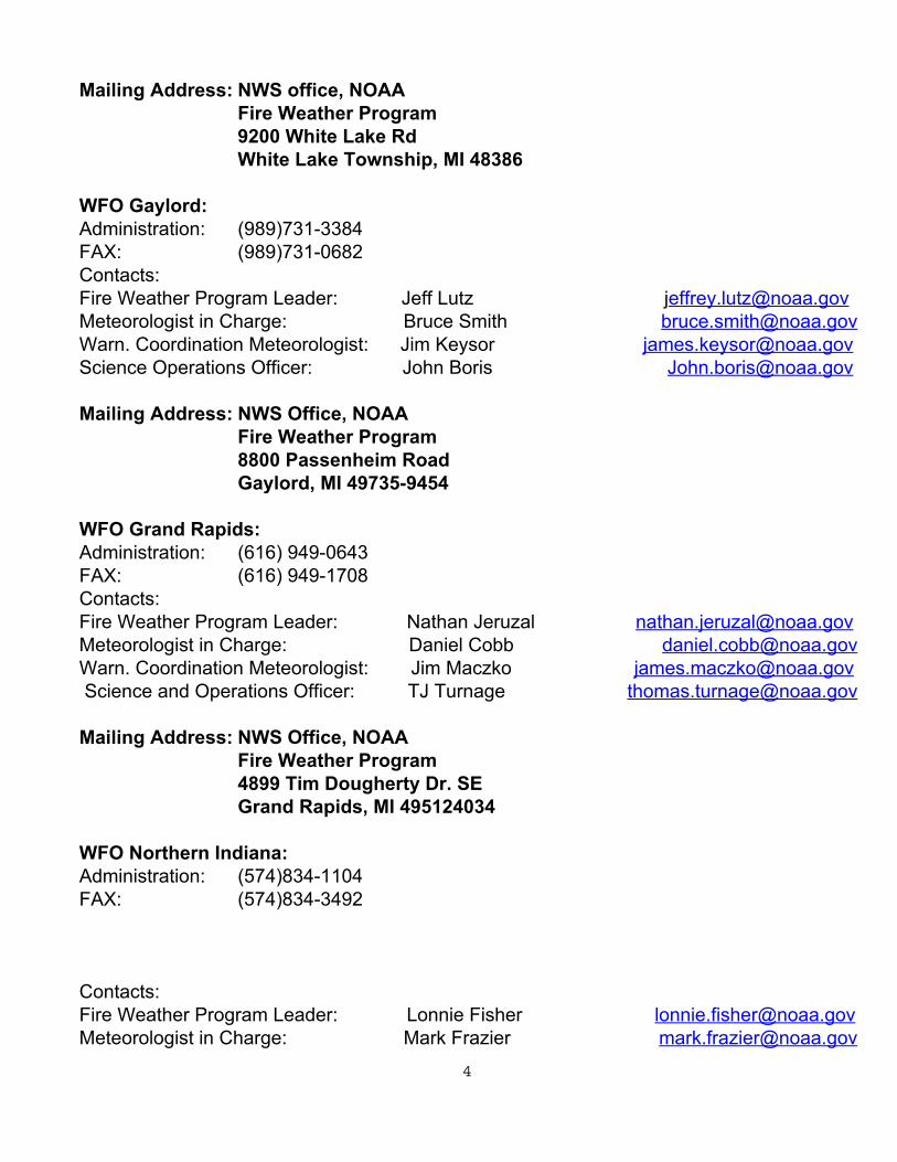
Mailing Address: NWS office, NOAA Fire Weather Program 9200 White Lake Rd White Lake Township, MI 48386
WFO Gaylord: Administration: (989)731-3384 FAX: (989)731-0682 Contacts: Fire Weather Program Leader: Jeff Lutz [email protected] Meteorologist in Charge: Bruce Smith [email protected] Warn. Coordination Meteorologist: Jim Keysor [email protected] Science Operations Officer: John Boris [email protected] Mailing Address: NWS Office, NOAA
Fire Weather Program 8800 Passenheim Road Gaylord, MI 49735-9454
WFO Grand Rapids: Administration: (616) 949-0643 FAX: (616) 949-1708 Contacts: Fire Weather Program Leader: Nathan Jeruzal [email protected] Meteorologist in Charge: Daniel Cobb [email protected] Warn. Coordination Meteorologist: Jim Maczko [email protected] Science and Operations Officer: TJ Turnage [email protected] Mailing Address: NWS Office, NOAA
Fire Weather Program 4899 Tim Dougherty Dr. SE Grand Rapids, MI 495124034
WFO Northern Indiana: Administration: (574)834-1104 FAX: (574)834-3492 Contacts: Fire Weather Program Leader: Lonnie Fisher [email protected] Meteorologist in Charge: Mark Frazier [email protected]
4

Warn. Coordination Meteorologist: Michael Lewis [email protected] Science Operations Officer: Jeffrey Logsdon [email protected] Mailing Address: NWS Office, NOAA
Fire Weather Program 7506 East 850 North Syracuse, IN 46567
WFO Marquette: Administration: (906)475-5782 FAX: (906)475-6305 Contacts: Fire Weather Program Leader: Asst. Fire Weather Program Leader: Jason Alumbaugh [email protected] Meteorologist in Charge: Robin J Turner [email protected] Warn. Coordination Meteorologist: Matt Zika [email protected] Science Operations Officer: David Beachler [email protected] Mailing Address: NWS Office, NOAA
Fire Weather Program 112 Airpark Drive South Negaunee, MI 49866-9526
Land Management Agency Contacts in Lower Michigan
Eastern Area Coordination Center (EACC) Main Office - Milwaukee Main Phone: (414)944-3811 Office Fax: (414)944-3838
Mailing Address: 626 E. Wisconsin Ave.
Suite 500 Milwaukee, WI 53202
EACC Fire Weather Program Manager – Stephen Marien [email protected] Main Phone: (651)293-8446 Office Fax: (651)290-3815
Mailing Address:
5

111 East Kellogg Blvd. Suite 105 St. Paul, MN 55101
U.S. Forest Service Huron-Manistee National Forest Supervisor’s Office (Cadillac) Chris A. Peterson – Forest FMO (231)775-5023 X8724 [email protected] Steve Nurse – Deputy FMO (231)775-5023 X8752 [email protected] Kim Owczarcak – Center Manager (231)775-5023 X8750 [email protected] Jae Naugle – Assistant Center Manager (231)775-5023 X8794 [email protected] Dispatcher (231)775-8732 Rod Mclean Fax: (231)775-8742
Mailing Address: 1755 South Mitchell St. Cadillac, MI 49601
West Zone (Baldwin/Manistee) Persephone Whelan – W. Zone FMO (231)723-2211 [email protected] Fax: (231)723-8642
East Zone (Huron Shores) Joseph Alyea – E. Zone FMO (989)739-0728 X3101 [email protected]
X3356 Fax: (989)739-0951 National Park Service Sleeping Bear Dunes National Lakeshore Phil Akers – Chief Ranger (231)326-4740 [email protected] Tom Davison – Park Dispatcher (231)326-4742
[email protected] Dispatch (231)326-4742 Fax (231)326-5653
Mailing Address: 9922 Front Street Hwy M-72 Empire, MI 49630
6

Indiana Dunes National Lakeshore Mel Whitenack - Fire Mgt Officer (219)395-1683 [email protected] U.S. Fish and Wildlife, Michigan U.S. Fish and Wildlife Refuges, (Michigan) Gary Lindsay – FMO, MI Satellite (906)586-9851 X19 [email protected] FAX (906)586-3800 Mailing Address: Seney National Wildlife Refuge 1674 Refuge Entrance Road Seney, MN 49883 U.S. Fish Wildlife North Zone (Michigan & Wisconsin) Dan Laber – WI & MI Zone FMO (608)565-4407 [email protected] Kirtland Wildlife Management Area, Seney National Wildlife Refuge & Michigan
Islands Greg McClellan – Dep. Refuge Manager (906)586-9851 X13 [email protected] Sara Siekierski - Refuge Manager (906)586-9851 X11 [email protected] Detroit River International Wildlife Refuge Steve Dushane – Dep. Refuge Manager (734) 692-7608 [email protected] John Hartig - Refuge Manager (734) 692-7608 [email protected] Shiawassee National Wildlife Refuge & Michigan Islands Eric Dunton - Biologist (989)777-5930 X103 [email protected] Pamela Repp – Refuge Manager (989)777-5930 X107 [email protected] Michigan Private Lands Office & Michigan Wetland Management District Jim Hazelman – Asst. State Coordinator (517)351-6235 [email protected] Jim Hudgins - State Coordinator (517)351-6235 [email protected] Bureau of Indian Affairs Will Wiggins (906)353-7289 (office) [email protected]
(906)353-7299 (fax) Mailing Address:
100 Hemlock Street Baraga, MI 49908
Michigan Dept of Natural Resources Roscommon - Phone (989)275-5151 or (989)275-5019
7

Roscommon - FAX (989)275-5167 Fire Duty officers and extensions: Don Klingler (989)275-5151 Ext. 2040 [email protected] Lee Osterland (989)275-5151 Ext. 2042 [email protected] Rita Defibaugh (989) 275-5151 Ext. 2920 [email protected]
Mailing Address: 8717 North Roscommon Rd. Roscommon, MI 48653
Land Management Agency Contacts in Upper Michigan
U.S. Forest Service Ottawa National Forest: Dispatch (231)775-8732 FMO - Jon Agner [email protected] Fax (906)358-4069 Mailing Address: E 32979 US Hwy 2 East Watersmeet, MI 49969 Hiawatha National Forest: Main Office (906)428-5800 FMO (906)428-5822 [email protected] Fax (906)428-9030 Mailing Address: 820 Rains Drive Gladstone, MI 49837 National Park Service Pictured Rocks National Lakeshore Dispatch (906)428-5891 Matt Davis – Chief Ranger (906)387-2607 X 203 [email protected] Mailing Address: N8391 Sand Point Road P.O. Box 40 Munising, MI 49862 Isle Royale National Park
8

Richard Moore – Chief Ranger (906)487-7148 [email protected] Marshall Plumer - East District Ranger (906)487-7174 [email protected] Mailing Address: 800 East Lakeshore Drive Houghton, MI 49931 U.S. Fish and Wildlife, Michigan Seney National Wildlife Refuge & Other Refuges in The UP Greg McClellan - Deputy Refuge Manager (906)586-9851 X13 [email protected] Sara Siekierski - Refuge Manager (906)586-9851 X11 [email protected] Michigan Dept of Natural Resources Marquette Dispatch Marquette – Phone (906)249-1497 Acting Duty Officer (906)249-9222 Celeste Chingwa – Protection Officer (906)249-2466 [email protected] Bruce Avery – Fire Specialist (906)249-3502 [email protected] Keith Murphy – Fire Specialist [email protected]
Mailing Address: 110 Ford Rd. Marquette, MI 49855
9

Routine Services provided by the National Weather Service
Format of Fire Planning Weather Forecasts and times of issuance are coordinated with the customers at the beginning of each season. The format of the fire weather products will comply with standards set forth in NWS Instruction 10-401. The format is standardized, in an effort to better serve transient fire fighters. The fire fighters can look at any National Weather Service Fire Weather Forecasts, and be familiar with the format so that critical weather information can be easily obtained. The National Fire Danger Rating System (Point) forecasts will be issued to determine fire danger on an as needed basis. These are initiated by the reception of 1300 (local time) observation at the designated points. Special forecasts, such as Spot Forecasts, will be issued as needed for on-going fires, prescribed burns, spraying or other special projects of the fire protection agencies. A red flag program will be maintained throughout the fire season, to support fire agencies in wildfire prevention and suppression tactics. Close liaison between the National Weather Service and the fire control agencies will be maintained to insure a smooth exchange of essential information. Below are the fire weather products issued by Weather Forecast Office Gaylord:
● ARBFWFAPX- Routine Fire Weather Forecast ● ARBFWMAPX- NFDRS (point) forecasts (Mio, Bear, Wellston, and Silver Creek) ● ARBFWSAPX- Spot Forecasts ● ARBRFWAPX- Fire Weather Watch or Red Flag Warning
Below are the fire weather products issued by Weather Forecast Office Grand Rapids:
● ARBFWFGRR- Routine Fire Weather Forecast ● ARBFWMGRR- NFDRS (point) forecasts (Baldwin) ● ARBFWSGRR- Spot Forecasts ● ARBRFWGRR- Fire Weather Watch or Red Flag Warning
Below are the fire weather products issued by Weather Forecast Office White Lake:
● ARBFWFDTX- Routine Fire Weather Forecast
10

● ARBFWSDTX- Spot Forecasts ● ARBRFWDTX- Fire Weather Watch or Red Flag Warning
Below are the fire weather products issued by Weather Forecast Office Northern Indiana:
● INDFWFIWX- Routine Fire Weather Forecast ● INDFWSIWX- Spot Forecasts ● INDRFWIWX- Fire Weather Watch or Red Flag Warning
Routine Fire Weather Forecast This forecast has two scheduled issuances, between 400 am and 700 am in the morning, and between 300 pm and 400 pm in the afternoon. The morning forecast will contain three periods and an extended forecast, while the afternoon forecast will contain four periods and an extended forecast. A standard fire zone grouping has been established to better facilitate information for areas that may experience similar conditions. Adjustment of these groupings can be performed on an as needed basis to address representative fuel conditions in a particular area after coordination with affected state and federal officials. These groupings will be reviewed at least annually. A graphic of the current zone grouping can be found in Appendix D. The forecasts will contain the following elements:
● Headline - The headline should capture the most important aspect of the forecast, or a trend. If a Red Flag Warning or Fire Weather Watch is in effect, then this becomes the headline.
● Discussion – This is a short paragraph outlining the synoptic features affecting the Great Lakes region during the next 24 to 36 hours. An outlook also may be produced to highlight potential dangerous fire weather conditions expected in the next few days.
● Other forecast elements will include: cloud cover, chance and type of precipitation, precipitation amount, max and min temperatures and its trend, max and min relative humidity and its trend, 20-foot winds in MPH, mixing height in 1000’s of feet, and transport winds in knots.
● Haines Index - This is a stability index with reportable values that range from 2 to 6. You can calculate the Haines Index by using model soundings.
● Ventilation Index (VI) - A smoke management tool used to measure the stability of the atmosphere, in order to indicate how effectively it will disperse fire generated pollutants.
● The extended forecast will be appended to the end of the tabular part of the product and will include the winds through day 7.
This forecast will be updated whenever the following conditions are warranted.
● A Fire Weather Watch is issued, cancelled or expired ● A Red Flag Warning is issued, cancelled or expired
11

● Current trends do not support the valid forecast Methods of receiving and accessing routine Fire Planning Weather Forecasts, is as follows:
● Agencies can routinely access the forecast via the internet at weather.gov/gaylord, weather.gov/grandrapids, weather.gov/detroit, weather.gov/northernindiana or through WIMS (Weather Information and Management System).
● If the above options are not available, then agencies are encouraged to call the respective National Weather Service Office directly.
NFDRS (point) Forecast The Point Forecast is issued for a specific point within the fire weather area of responsibility (see stations below) and is valid for a twenty-four (24) hour period (through 100 pm the following day). For example, if the NPS wants a Point Forecast for Wednesday at “The Bear”, they will send the 100 pm weather conditions from the site on Tuesday to serve as a reference for the forecast. The Point Forecast for The Bear, would be valid through 100 pm the next day (in this case it would be a Point Forecast for Wednesday at 100 pm at BEAR). Point forecast Stations: Station ID # COUNTY AGENCY LAT LON Office: GRR Baldwin 203802 Lake USFS 43.9 85.8 Office: APX Mio 202902 Oscoda USFS 44.4 84.1 Bear 202010 Leelanau NPS 44.5 86.0 Wellston 203101 Manistee USFS 44.2 85.9 Silver Creek 203601 Iosco USFS 44.4 83.6 The format for NFDRS forecast is found in NWS Instruction 10-401. Spot Forecasts This forecast is prepared for a single location for a very distinct period of time, usually 6 to 12 hours. The forecast is usually requested by federal and state agencies during wildfires or prescribed burns. The forecast elements will usually consist of the highest or lowest temperature during the period, the highest or lowest relative humidity, wind direction and speed, chances of precipitation and duration. Spot Forecast requests can come into the office by several means, the internet, by fax, or by phone. The preferred method for requesting or receiving Spot Forecasts will be via the internet. If internet usage is not possible for requesting or receiving Spot Forecasts, then
12
requesting agencies should call the respective NWS office to request the forecast. Instructions for submitting a Spot Forecast request by user agencies, and instructions for completing the Spot Forecast by National Weather Service employees via the internet, are found in Appendix B. When a request for a Spot Forecast is made by phone, National Weather Service employees should use the Spot Forecast form to help prepare the forecast. Upon receiving a call for a Spot Forecast, the NWS forecaster should ask for the location lat/lon, current observation including temperatures, relative humidity, wind direction and speed location. Elevation, aspect, fuel type, and requesting official and contact phone number should also be given for the site before beginning the forecast process. Whether the Spot Forecast request is made by phone or the internet, NWS employees will complete the request utilizing the internet process (Appendix B). When the forecast is submitted it will produce a product in AWIPS, which is printed automatically and stored locally. This form can be used for faxing. Experimental Model Smoke Plumes Land management agencies that have a wildfire of 100 acres or greater, or are conducting a prescribed burn of 100 acres or greater, may request that the local National Weather Service Office run the NOAA Air Resources Laboratory dispersion model, HYSPLIT, to model smoke dispersion. This model is a combination of the U.S. Forest Service’s Blue Sky Model and meteorological models used by NWS Forecasters. This data is output in a graphical form and is considered experimental since it is relatively new, and only limited testing has been conducted thus far. This data can be used in addition to a typical spot forecast that is used for Prescribed Burns and Wildfires. More information on the procedures for requesting this and how to interpret the data can be found in Appendix E at the end of this AOP. Weekly Fire Weather Briefings During the months of April and May, a weekly weather briefing will conducted by a NWS Meteorologist from one of the four NWS offices that service the land management agencies in Lower Michigan. Additional briefings may be requested by the land management agencies outside of this time period. The purpose of these briefings will be to provide an outlook of weather to assist the agencies in the planning of resources out through seven days during the active portion of the fire season. The day and time of these briefings will be determined by coordination between the NWS offices and all of the land management agencies. The webinars should include the use of the web based “Join.Me” software, and a conference call. The briefing will be then emailed out to the contacts on the webinar list. In addition to the weekly briefing listed above, a briefing concerning an expected Red Flag event will be conducted by the NWS offices when requested by the land management
13

agencies. This request will likely come during the weekly fire weather briefing. Please see more details on the Red Flag webinar under the Watch/Warning Events section.
Watch/Warning Events
Fire Weather Watches and Red Flag Warnings A Fire Weather Watch or Red Flag Warning is issued whenever extremely dry fuels are forecast to combine with critical weather parameters to create an atmosphere that could contribute to extensive wildfires with the potential to threaten life and property. Any watch or warning should be coordinated with the affected land management agency for the zone(s) where the watch or warning is being considered or has been issued. A Red Flag warning may also be requested by a land management agency, if they feel that due to extreme dryness in the forest, that wildfires are likely. Otherwise, if conditions are expected to be close to or exceed red flag conditions, then an appropriate statement should be put into the Hazardous Weather Outlook (ARBHWOxxx and INDHWOIWX for far Southern Lower Michigan counties covered by Northern Indiana). Fire Weather Watch Criteria Whenever a geographical area has been dry for a week or two (or for a shorter period if before spring green-up or after fall color), the National Fire Danger Rating System (NFDRS) is high to extreme and critical weather conditions are expected then a Fire Weather Watch should be considered. Before issuing a Fire Weather Watch, coordinate you concerns with the pertinent land management agencies. Consider a watch, whenever the above conditions will combine with these forecast weather parameters within the next 24 to 48 hours are:
1. Sustained wind averaging >= 15 mph (20 ft RAWS winds) or >=20 mph (10m ASOS winds)
2. Relative humidity <= 25 percent 3. Temperature >= 75 degrees. (Frequent wind gusts reaching the above wind criteria may be used in place of sustained winds at WFO’s APX and GRR. This is to increase flexibility and provide additional support when needed to National Forest lands; and to account for differences in land use and fuel types that may be more sensitive to potential wildfire spread across portions of Northern and Western Lower Michigan.)
Red Flag Warning Criteria A Red Flag Warning will be issued when the Fire Weather Forecaster has a high degree of
14

confidence that all three critical weather conditions, listed below, will occur within 24 hours.
1. Sustained wind averaging >= 15 mph (20 ft RAWS winds) or >=20 mph (10m ASOS winds)
2. Relative humidity <= 25 percent and 3. Temperature >= 75 degrees. (Frequent wind gusts reaching the above wind criteria may be used in place of sustained winds at WFO’s APX and GRR. This is to increase flexibility and provide additional support when needed to National Forest lands; and to account for differences in land use and fuel types that may be more sensitive to potential wildfire spread across portions of Northern and Western Lower Michigan.)
The fire weather watch or red flag warning can be issued on a county by county basis. The land management agencies and the NWS offices will discuss the area that will be contained within the urgent fire weather message. Issuing a Red Flag Warning or Fire Weather Watch Call the affected land management agency for the zone where the watch or warning was issued to inform them of the warning and to coordinate what information is to be included in any public statement.
1. Issue the Red Flag Warning as ARBRFWxxx or INDRFWIWX (Northern Indiana). 2. The warning will include the geographic area, duration of the event and key weather
parameters. 3. Headline in the daily Fire Weather Forecast (ARBFWFxxx or INDFWFIWX). 4. Subsequent Red Flag Warning messages or routine weather forecasts will carry the
warning or watch headline until it is canceled. Fire Weather Watch/Red Flag Warning Cancellation/Expiration
1. Issue the ARBRFWxxx or INDRFWIWX to cancel the watch or warning. 2. Headline the cancellation in the daily Fire Weather Forecast.
Marginal Events When conditions are expected to approach Red Flag Warning conditions, a coordination call should take place between the NWS and the various land management agencies. This coordination call will determine whether a Red Flag Warning is required, or whether notification to raise the awareness of the elevated fire danger is desired. The notification includes web stories on NWS web pages, message notification to Emergency Managers and media, mention in the Hazardous Weather Outlook, and Social Media. Verification
15

Fire Weather Watches and Red Flag Warnings will be verified based on synoptic events. Verification of Red Flag events will be tracked for all fire weather zones. The criteria are as stated previously. Webinars Webinars will be provided to the land management agencies as requested prior to a Red Flag event. The webinars will be conducted similar to the weekly webinars as listed above. The content will include important, yet simple information to help the land management agencies make decisions pertaining to the potential Red Flag event.
Non-routine services
The National Weather Service will assist any Federal or State agency in training purposes. Typically, the National Weather Service has served as instructors for the weather portions of the S-290 and S-190 hosted by the USFS or DNR. On different occasions, the National Weather Service has also agreed to supply training/instruction support for state and federal agencies in more general purposes, such as seasonal outlooks during late winter staff meetings or regional gatherings. This type of service will continue in the future.
Wildland Fire Agency Responsibilities
The agency responsibility will be as noted in the Interagency Agreement for Meteorological Services, between federal and state user agencies and the National Weather Service. This has been appended.
Effective Date of the AOP
The beginning and ending dates of the fire weather season are determined by federal and state agencies in coordination with the National Weather Service Fire Weather Program Leader at the respective weather forecast office. These dates are a function of the first or last snow and by the state of vegetation. Typically the fire weather season for Lower Michigan extends from mid-March through mid-November.
16

This page intentionally left blank
17
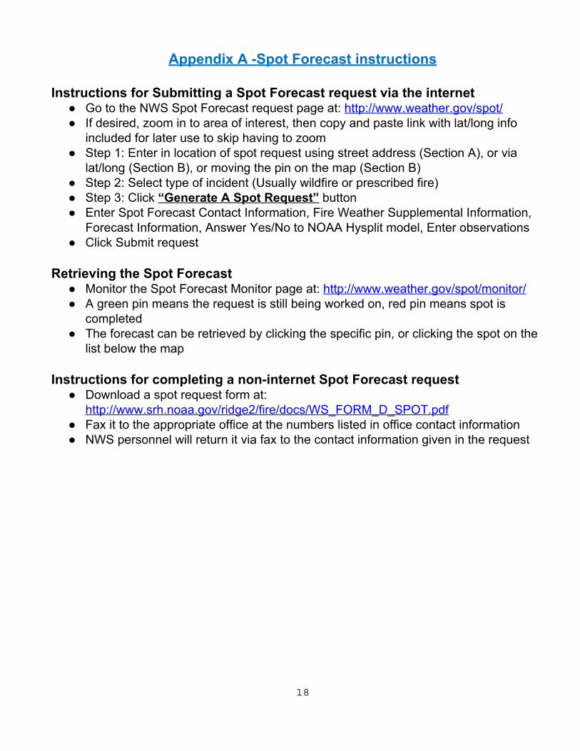
Appendix A -Spot Forecast instructions
Instructions for Submitting a Spot Forecast request via the internet ● Go to the NWS Spot Forecast request page at: http://www.weather.gov/spot/ ● If desired, zoom in to area of interest, then copy and paste link with lat/long info
included for later use to skip having to zoom ● Step 1: Enter in location of spot request using street address (Section A), or via
lat/long (Section B), or moving the pin on the map (Section B) ● Step 2: Select type of incident (Usually wildfire or prescribed fire) ● Step 3: Click “Generate A Spot Request” button ● Enter Spot Forecast Contact Information, Fire Weather Supplemental Information,
Forecast Information, Answer Yes/No to NOAA Hysplit model, Enter observations ● Click Submit request
Retrieving the Spot Forecast
● Monitor the Spot Forecast Monitor page at: http://www.weather.gov/spot/monitor/ ● A green pin means the request is still being worked on, red pin means spot is
completed ● The forecast can be retrieved by clicking the specific pin, or clicking the spot on the
list below the map Instructions for completing a non-internet Spot Forecast request
● Download a spot request form at: http://www.srh.noaa.gov/ridge2/fire/docs/WS_FORM_D_SPOT.pdf
● Fax it to the appropriate office at the numbers listed in office contact information ● NWS personnel will return it via fax to the contact information given in the request
18
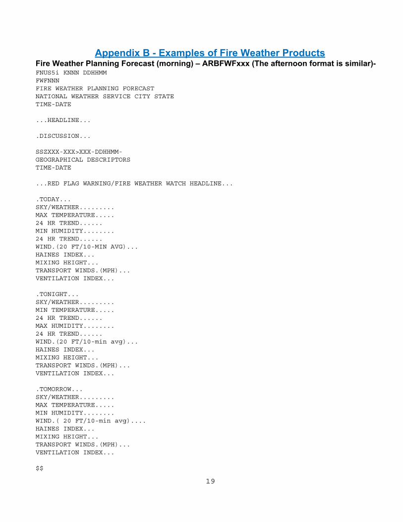
Appendix B - Examples of Fire Weather Products
Fire Weather Planning Forecast (morning) – ARBFWFxxx (The afternoon format is similar)- FNUS5i KNNN DDHHMM FWFNNN FIRE WEATHER PLANNING FORECAST NATIONAL WEATHER SERVICE CITY STATE TIME-DATE ...HEADLINE... .DISCUSSION... SSZXXX-XXX>XXX-DDHHMM- GEOGRAPHICAL DESCRIPTORS TIME-DATE ...RED FLAG WARNING/FIRE WEATHER WATCH HEADLINE... .TODAY... SKY/WEATHER......... MAX TEMPERATURE..... 24 HR TREND...... MIN HUMIDITY........ 24 HR TREND...... WIND.(20 FT/10-MIN AVG)... HAINES INDEX... MIXING HEIGHT... TRANSPORT WINDS.(MPH)... VENTILATION INDEX... .TONIGHT... SKY/WEATHER......... MIN TEMPERATURE..... 24 HR TREND...... MAX HUMIDITY........ 24 HR TREND...... WIND.(20 FT/10-min avg)... HAINES INDEX... MIXING HEIGHT... TRANSPORT WINDS.(MPH)... VENTILATION INDEX... .TOMORROW... SKY/WEATHER......... MAX TEMPERATURE..... MIN HUMIDITY........ WIND.( 20 FT/10-min avg).... HAINES INDEX... MIXING HEIGHT... TRANSPORT WINDS.(MPH)... VENTILATION INDEX... $$
19

.FORECAST FOR DAYS 3 THROUGH 7... .DAY3... .DAY4... .DAY5... .DAY6... .DAY7...
Fire Weather Watch/Red Flag Warning (RFW). Single Segment Fire Weather Watch (Red Flag Warning is similar except headline in the body of the product would say “RED FLAG WARNING IN EFFECT” and there would be different coding at the top.) WWUS83 Kxxx 012130 RFWxxx URGENT - FIRE WEATHER MESSAGE NATIONAL WEATHER SERVICE Office MI 330 PM EDT WED MAY 1 2011 MIZXXX-XXX-021800- /O.NEW.KXXX.FW.A.0005.110502T1800Z-110503T0200Z/ COUNTY1-COUNTY2-COUNTY3-COUNTY4-COUNTY5 330 PM EDT WED MAY 1 2011 ...FIRE WEATHER WATCH IN EFFECT THURSDAY AFTERNOON AND THURSDAY EVENING... THE NATIONAL WEATHER SERVICE IN XXXXXX HAS ISSUED A FIRE WEATHER WATCH…WHICH IS IN EFFECT FOR THURSDAY AFTERNOON AND EVENING. * WINDS…SOUTHWEST WINDS 10 TO 20 MPH WITH FREQUENT GUSTS TO 30 MPH THURSDAY AFTERNOON AND EVENING. * RELATIVE HUMIDITY…HUMIDITIES WILL BOTTOM OUT IN THE 15 TO 20 PERCENT RANGE LATE THURSDAY AFTERNOON. HUMIDITIES WILL RECOVER QUICKLY AFTER 9 PM. * TEMPERATURES…TEMPERATURES WILL WARM INTO THE 83-88 DEGREE RANGE BY LATE AFTERNOON ON THURSDAY. * IMPACTS…BURN RESTRICTIONS ARE IN EFFECT. FOR MORE INFORMATION ON BURN RESTRICTIONS…VISIT THE MICHIGAN DNR WEBSITE AT WWW.MICHIGAN.GOV/BURNPERMIT OR CALL 866-922-2876. PRECAUTIONARY/PREPAREDNESS ACTIONS… A FIRE WEATHER WATCH MEANS THAT CRITICAL FIRE WEATHER CONDITIONS ARE FORECAST TO OCCUR. LISTEN FOR LATER FORECASTS AND POSSIBLE RED FLAG WARNINGS. && $$
20

Multiple Segment Fire Weather Watch (Red Flag Warning is similar except headline in the body of the product would say “RED FLAG WARNING IN EFFECT” and there would be different coding at the top.) WWUS83 Kxxx 012130 RFWxxx URGENT - FIRE WEATHER MESSAGE NATIONAL WEATHER SERVICE Office MI 330 PM EDT WED MAY 1 2011 MIZXXX-XXX-021800- /O.NEW.KXXX.FW.A.0005.110502T1800Z-110503T0200Z/ COUNTY1-COUNTY2-COUNTY3-COUNTY4-COUNTY5 330 PM EDT WED MAY 1 2011 ...FIRE WEATHER WATCH IN EFFECT THROUGH THURSDAY AFTERNOON... THE NATIONAL WEATHER SERVICE IN XXXXXX HAS ISSUED A FIRE WEATHER WATCH…WHICH IS IN EFFECT FOR THURSDAY AFTERNOON AND EVENING. * WINDS…SOUTHWEST WINDS 10 TO 20 MPH WITH FREQUENT GUSTS TO 30 MPH THURSDAY AFTERNOON AND EVENING. * RELATIVE HUMIDITY…HUMIDITIES WILL BOTTOM OUT IN THE 15 TO 20 PERCENT RANGE LATE THURSDAY AFTERNOON. HUMIDITIES WILL RECOVER QUICKLY AFTER 9 PM. * TEMPERATURES…TEMPERATURES WILL WARM INTO THE 83-88 DEGREE RANGE BY LATE AFTERNOON ON THURSDAY. * IMPACTS…BURN RESTRICTIONS ARE IN EFFECT. FOR MORE INFORMATION ON BURN RESTRICTIONS…VISIT THE MICHIGAN DNR WEBSITE AT WWW.MICHIGAN.GOV/BURNPERMIT OR CALL 866-922-2876. PRECAUTIONARY/PREPAREDNESS ACTIONS… A FIRE WEATHER WATCH MEANS THAT CRITICAL FIRE WEATHER CONDITIONS ARE FORECAST TO OCCUR. LISTEN FOR LATER FORECASTS AND POSSIBLE RED FLAG WARNINGS. $$ MIZXXX-XXX-021800- /O.NEW.KXXX.FW.A.0005.110502T1800Z-110503T0200Z/ COUNTY6-COUNTY7-COUNTY8-COUNTY9-COUNTY10 330 PM EDT WED MAY 1 2011 ...FIRE WEATHER WATCH IN EFFECT THURSDAY AFTERNOON AND THURSDAY EVENING... THE NATIONAL WEATHER SERVICE IN XXXXXX HAS ISSUED A FIRE WEATHER WATCH…WHICH IS IN EFFECT FOR THURSDAY AFTERNOON AND EVENING. * WINDS…SOUTHWEST WINDS 10 TO 20 MPH WITH FREQUENT GUSTS TO 30 MPH THURSDAY AFTERNOON AND EVENING. * RELATIVE HUMIDITY…HUMIDITIES WILL BOTTOM OUT IN THE 15 TO 20 PERCENT RANGE LATE THURSDAY AFTERNOON. HUMIDITIES WILL RECOVER QUICKLY AFTER 9 PM.
21
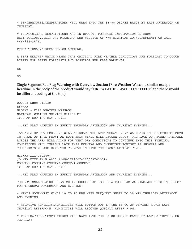
* TEMPERATURES…TEMPERATURES WILL WARM INTO THE 83-88 DEGREE RANGE BY LATE AFTERNOON ON THURSDAY. * IMPACTS…BURN RESTRICTIONS ARE IN EFFECT. FOR MORE INFORMATION ON BURN RESTRICTIONS…VISIT THE MICHIGAN DNR WEBSITE AT WWW.MICHIGAN.GOV/BURNPERMIT OR CALL 866-922-2876. PRECAUTIONARY/PREPAREDNESS ACTIONS… A FIRE WEATHER WATCH MEANS THAT CRITICAL FIRE WEATHER CONDITIONS ARE FORECAST TO OCCUR. LISTEN FOR LATER FORECASTS AND POSSIBLE RED FLAG WARNINGS. && $$ Single Segment Red Flag Warning with Overview Section (Fire Weather Watch is similar except headline in the body of the product would say “FIRE WEATHER WATCH IN EFFECT” and there would be different coding at the top.) WWUS83 Kxxx 012130 RFWxxx URGENT - FIRE WEATHER MESSAGE NATIONAL WEATHER SERVICE Office MI 1030 AM EDT THU MAY 2 2011 ...RED FLAG WARNING IN EFFECT THURSDAY AFTERNOON AND THURSDAY EVENING... .AN AREA OF LOW PRESSURE WILL APPROACH THE AREA TODAY. VERY WARM AIR IS EXPECTED TO MOVE IN AHEAD OF THIS FRONT AS SOUTHERLY WINDS WILL BECOME GUSTY. THE LACK OF RECENT RAINFALL ACROSS THE AREA WILL ALLOW FOR VERY DRY CONDITIONS TO CONTINUE INTO THIS EVENING. CONDITIONS WILL IMPROVE LATE THIS EVENING AND OVERNIGHT TONIGHT AS SHOWERS AND THUNDERSTORMS ARE EXPECTED TO MOVE IN WITH THE FRONT AT THAT TIME. MIZXXX-XXX-030200- /O.NEW.KXXX.FW.W.0005.110502T1800Z-110503T0200Z/ COUNTY1-COUNTY2-COUNTY3-COUNTY4-COUNTY5 1030 AM EDT THU MAY 2 2011 ...RED FLAG WARNING IN EFFECT THURSDAY AFTERNOON AND THURSDAY EVENING... THE NATIONAL WEATHER SERVICE IN XXXXXX HAS ISSUED A RED FLAG WARNING…WHICH IS IN EFFECT FOR THURSDAY AFTERNOON AND EVENING. * WINDS…SOUTHWEST WINDS 10 TO 20 MPH WITH FREQUENT GUSTS TO 30 MPH THURSDAY AFTERNOON AND EVENING. * RELATIVE HUMIDITY…HUMIDITIES WILL BOTTOM OUT IN THE 15 TO 20 PERCENT RANGE LATE THURSDAY AFTERNOON. HUMIDITIES WILL RECOVER QUICKLY AFTER 9 PM. * TEMPERATURES…TEMPERATURES WILL WARM INTO THE 83-88 DEGREE RANGE BY LATE AFTERNOON ON THURSDAY.
22

* IMPACTS…BURN RESTRICTIONS ARE IN EFFECT. FOR MORE INFORMATION ON BURN RESTRICTIONS…VISIT THE MICHIGAN DNR WEBSITE AT WWW.MICHIGAN.GOV/BURNPERMIT OR CALL 866-922-2876. PRECAUTIONARY/PREPAREDNESS ACTIONS… A FIRE WEATHER WATCH MEANS THAT CRITICAL FIRE WEATHER CONDITIONS ARE FORECAST TO OCCUR. LISTEN FOR LATER FORECASTS AND POSSIBLE RED FLAG WARNINGS. && $$
NFDRS Point Forecast - ARBFWMxxx: FCST,202902,950323,13,7,21,85,1,1,NW,10,M,26,9,100,60,2,2,N FCST,202010,950323,13,7,29,90,1,1,SW,12,M,34,14,90,60,2,2,N
23

Appendix C - Explanation of Fire Weather indices Haines Index (Low elevations):
The Haines index is an Atmospheric severity Index used to determine fire severity due to the stability of the lower atmosphere, typically used for days when plume dominated fires are likely. The terms in the index are the lapse rate between 950mb and 850mb (F1) and the moisture availability at 850mb by calculating the dew point depression (F2). Once the lapse rate and dew point depressions have been calculated, look up the appropriate value for each term (A and B) and add the numbers together (A+B). The lowest the index will be is 2 and the highest is 6. Haines Index = A + B F1 = T950 - T850 F1 = 3 deg C or less then A = 1 F1 = 4-7 C then A = 2 F1 = 8 deg C or more then A = 3 F2 = T850 - Td850 F2 = 3 deg C or less then B = 1 F2 = 4-7 C then B = 2 F2 = 8 deg C or more then B = 3 Ventilation Index: This index is found by multiplying the mixing height (feet) with the transport wind speed (mph), then dividing by 100.
Example... Mixing height = 14,000 feet Transport wind = 15 mph VI = 14,000 * 15 / 100 = 2100(no units) Example... Mixing height = 5,000 feet Transport wind = 10 mph VI = 5,000 * 10 / 100 = 500 (no units) VI scale... Less than 130 = POOR dispersal 130 – 299 = FAIR dispersal 300 – 599 = GOOD dispersal 600 and greater = EXCELLENT dispersal
A ventilation index of zero implies no ability for the atmosphere to disperse smoke or pollutants, while a value of 600 or greater implies an excellent ability to disperse smoke or pollutants. The United States Forest Service and Department of Natural Resources has requested that when the VI is “fair”, that we include a number value along with the term.
24
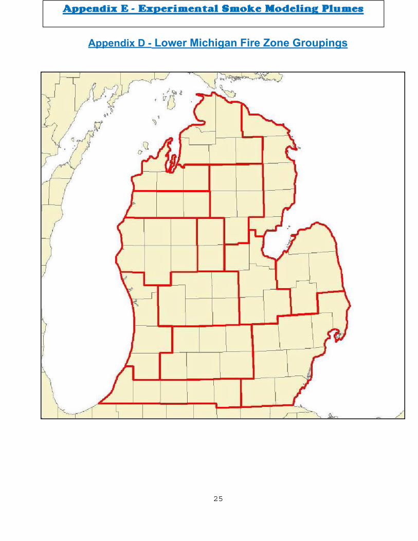
Appendix D - Lower Michigan Fire Zone Groupings
25

26

27

28