
How to specify the way the posts will be displayed in your blog's main page
What is StreamStats? • A web-service-based application that provides
information used by engineers, hydrologists, managers, planners, and others to make informed decisions on water-related activities
• Primary products are basin delineations, basin characteristics, and estimates of streamflow statistics
• Provides information for gaged and user-selected ungaged sites on streams
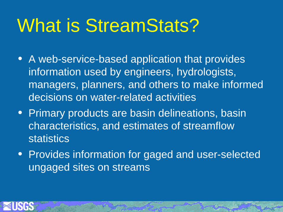
StreamStats Home Page
3
http://streamstats.usgs.gov
Development Team • John Guthrie, CO, IT support/programmer • Tana Haluska, OR, GIS specialist • Katharine Kolb, NC, GIS specialist • Jeremy Newson, WiM-ID, programmer • Kernell Ries, Ofc. of Surface Water-MD, coordinator • Martyn Smith, WiM-NY, programmer • Peter Steeves, MA, GIS specialist • Ryan Thompson, SD, GIS specialist • Contractors
ESRI (GIS programming) and Respec (database programming)
4
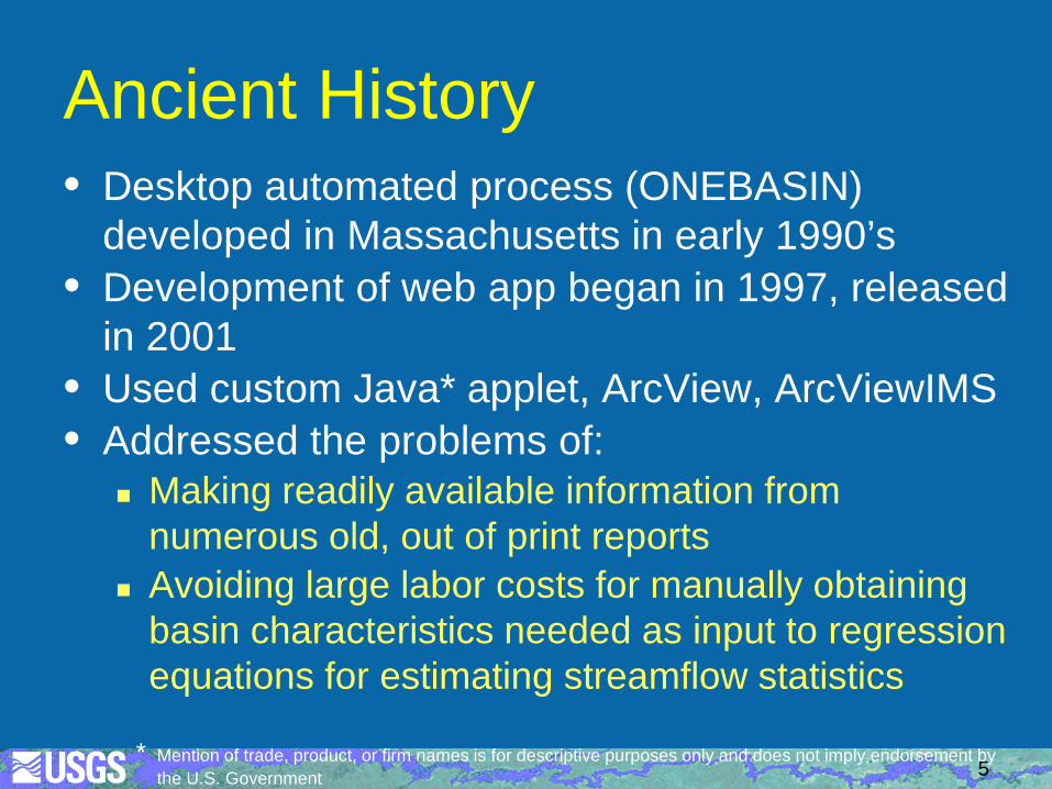
Ancient History • Desktop automated process (ONEBASIN)
developed in Massachusetts in early 1990’s • Development of web app began in 1997, released
in 2001 • Used custom Java* applet, ArcView, ArcViewIMS • Addressed the problems of:
Making readily available information from numerous old, out of print reports
Avoiding large labor costs for manually obtaining basin characteristics needed as input to regression equations for estimating streamflow statistics
5 * Mention of trade, product, or firm names is for descriptive purposes only and does not imply endorsement by
the U.S. Government
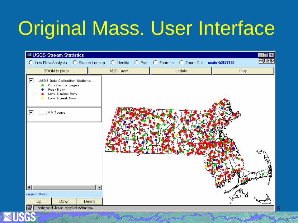
Original Mass. User Interface
6
National Effort • USGS Office of Surface Water began
national effort in 2001 with $200K budget • Mass. application not scalable for use
nationally • Initial national development done through
CRADA between USGS and ESRI
7
StreamStats Version 1 • Based on ArcMap and ArcIMS • Highly integrated with ArcHydro model and
tools • Could be configured for any state • Added abilities to edit basin boundaries and
download boundaries, basin characteristics, and flow estimates in shapefiles
• Idaho became first State available to public in Jan. 2005
8
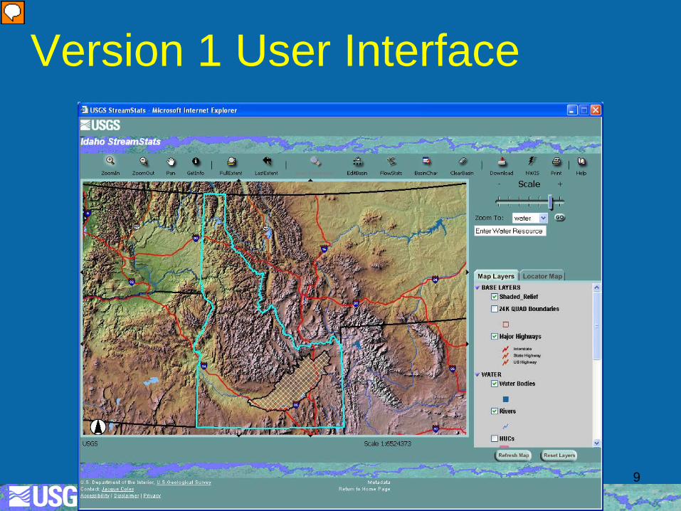
Version 1 User Interface
9
Version 1 Design Principles • Separate applications for each state using
map projections preferred by the states • Flexibility in scales of base data (elevation,
streams, watershed boundaries) used for delineations
• States could add custom tools • Statistics provided for streamgages must be
published previously and reports must be posted on line
10
Funding Model • The national development team is funded by
the National Streamflow Information Program, now GW and SW Information Program
• Water Science Centers are assessed annually to cover IT costs for each implemented state FY16 assessment was $6,400/state
• Water Science Centers enter into cooperative agreements with other entities (usually state agencies), who provide at least half of the funding needed to implement the states Average cost per state is about $300,000
11
StreamStats Version 2 • Based on ArcGIS Server 9.2 • New user interface with additional zoom
functions • New functionality, including stream network
navigation, drainage-area ratio estimates for ungaged sites, and editing of computed basin characteristics to obtain revised regression-equation-based flow estimates
• Batch process, some web services • Released for MA and UT during Oct. 2008
12
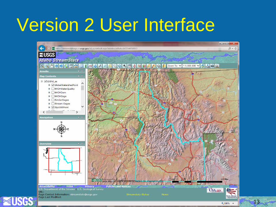
Version 2 User Interface
13
StreamStats Version 3 • Originally to be based on ArcGIS Server 9.3 • Began development in 2012, but restarted
after release of ArcGIS Server 10.1 • Released July 2015 with additional zoom
functions but without network-navigation tools from version 2
• All functionality developed as web services, which are de-coupled from user interface
• Reduced need to keep up with new ESRI releases
14
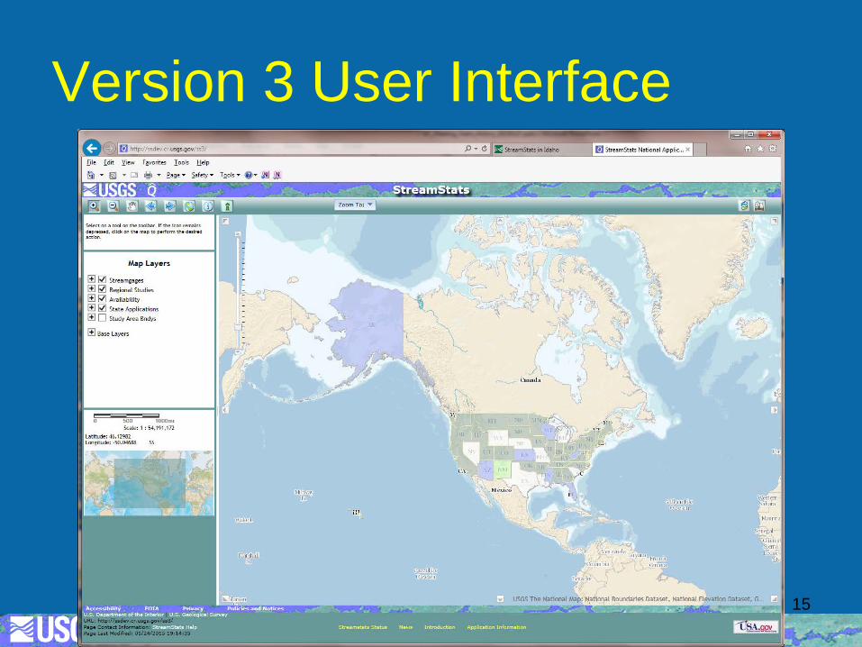
Version 3 User Interface
15
StreamStats Beta Version 4 • Began development in 2015, released in beta
during March 2016 • Much different, more intuitive, single national
user interface • Restores abilities to edit and download basins,
and get elevation profiles • All functionality initially uses same web services
as in version 3 • Ungaged site outputs now include maps • Improved support utility
16
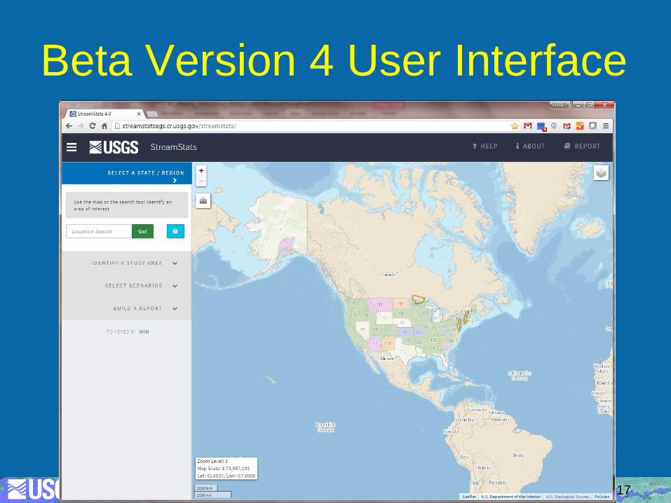
Beta Version 4 User Interface
17
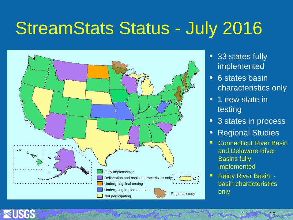
StreamStats Status - July 2016 • 33 states fully
implemented • 6 states basin
characteristics only • 1 new state in
testing • 3 states in process • Regional Studies Connecticut River Basin
and Delaware River Basins fully implemented
Rainy River Basin - basin characteristics only
Fully Implemented
Undergoing Implementation
Undergoing final testing
Not participating
Delineation and basin characteristics only
Regional study
18
Done So Far in FY16 • Released beta version 4 on March 26 • Released basin-characteristics-only
applications for AK, MS, SC, WI, Delaware River Basin (water use)
• Updates of equations and/or data for GA, ME, OH (water use), OR
19
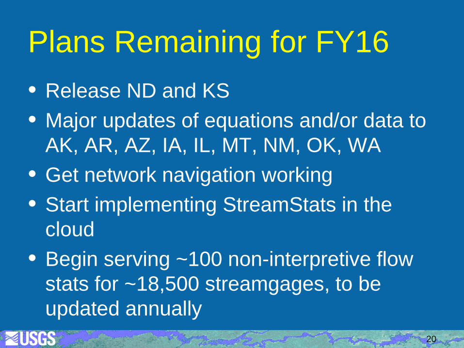
Plans Remaining for FY16 • Release ND and KS • Major updates of equations and/or data to
AK, AR, AZ, IA, IL, MT, NM, OK, WA • Get network navigation working • Start implementing StreamStats in the
cloud • Begin serving ~100 non-interpretive flow
stats for ~18,500 streamgages, to be updated annually
20
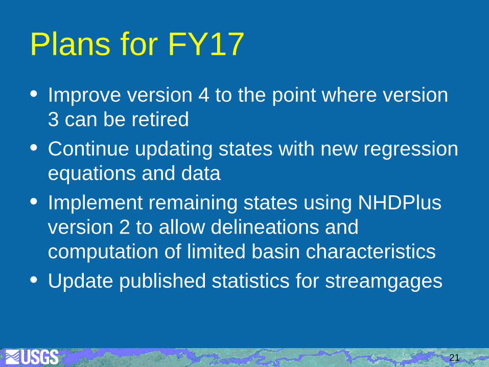
Plans for FY17 • Improve version 4 to the point where version
3 can be retired • Continue updating states with new regression
equations and data • Implement remaining states using NHDPlus
version 2 to allow delineations and computation of limited basin characteristics
• Update published statistics for streamgages
21
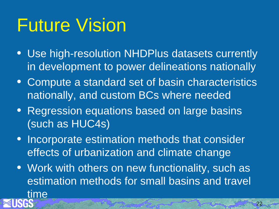
Future Vision • Use high-resolution NHDPlus datasets currently
in development to power delineations nationally • Compute a standard set of basin characteristics
nationally, and custom BCs where needed • Regression equations based on large basins
(such as HUC4s) • Incorporate estimation methods that consider
effects of urbanization and climate change • Work with others on new functionality, such as
estimation methods for small basins and travel time
22