GoldofthePharaohs–6000yearsofgoldmininginEgyptandNubiarjstern/egypt/PDFs/SE Desert/KlemmAU... ·...
17
Gold of the Pharaohs – 6000 years of gold mining in Egypt and Nubia Dietrich Klemm a, * , Rosemarie Klemm b , Andreas Murr a a Institut f€ ur Allgemeine und Angewandte Geologie, Ludwig-Maximilians-Universit€ atM€ unchen, Luisenstrasse 37, D-80333 M€ unchen, Germany b Institut f€ ur € Agyptologie, Ludwig-Maximilians-Universit€ atM€ unchen, Meiserstrasse 10, D-80333 M€ unchen, Germany Received 18 April 2001; accepted 27 July 2001 Abstract The legendary wealth in gold of ancient Egypt seems to correspond with an unexpected high number of gold production sites in the Eastern Desert of Egypt and Nubia. This contribution introduces briefly the general geology of these vast regions and discusses the geology of the different varieties of the primary gold occurrences (always related to auriferous quartz mineralization in veins or shear zones) as well as the variable physico-chemical genesis of the gold concentrations. The development of gold mining over time, from Predynastic (ca. 3000 BC) until the end of Arab gold production times (about 1350 AD), including the spectacular Pharaonic periods is outlined, with examples of its remaining artefacts, settlements and mining sites in remote regions of the Eastern Desert of Egypt and Nubia. Finally, some estimates on the scale of gold production are presented. Ó 2002 Published by Elsevier Science Ltd. Keywords: Auriferous quartz vein and shear zone mineralisation; Mining; Pharaonic dynastic periods; Gold production 1. Introduction The natural southern border of Ancient Egypt was the region around Aswan with settlements on the Nile island of Elephantine. The desert region east of this lo- cation was more or less under Pharaonic control, at least during the Old Kingdom (2700–2160 BC) and Middle Kingdom (2119–1794 BC) but also during New King- dom (1550–1070 BC) times, whereas during the different intermediate periods less Egyptian control of the East- ern Desert is documented. Large parts of this Eastern Desert belong geologically to the Precambrian basement of the Arabian–Nubian shield and host around 250 gold production sites, which were mined during different pe- riods of ancient Egyptian history. Most of these sites were visited by the authors during four field campaigns between 1989 and 1993, and three additional campaigns during 1996–1999 in the Sudanese Nubian Desert (see Figs. 9 and 10, discussed later). In the 1960s and 1970s expert teams of the Egyptian Geological Research Authority (EGSMA), the Geologi- cal Research Authority of the Sudan (GRAS) and the Soviet Techno Export group carried out extensive gold prospection programs in Egypt and NE Sudan. At the locations of all economically significant gold anomalies they discovered traces of extant mining such as stone mills, remains of settlements and mine-shafts, indicating a long history of ancient extraction. Unfortunately these expert groups never co-operated with archaeological specialists in order to classify the many remaining ancient mining traces and tools and this interesting aspect of historical prospecting efforts was thus left uninvestigated. It was the goal of the stud- ies described here to fill this gap; thanks to generous funding from the German Volkswagen Foundation, we were able to visit, in co-operation with EGSMA and GRAS, most of the known gold production sites and even to rediscover quite a number of hitherto unknown ancient mining locations. The most important aim of our expeditions was a systematic survey, encompassing archaeological inspec- tion and classification of the remaining, mostly previ- ously undescribed archaeological surface inventory and material, and a preliminary investigation of the geo- logical setting of the mining sites. Additionally, infor- mation was sought on the prospecting, exploitation and ore processing methods of the ancient miners. In modern times mineral exploration is assisted by complex computer aided processing of satellite spectral imagery, highly sophisticated geochemical, petrographi- cal and geophysical investigations, together with detailed geological field work. Nothing of that kind was available African Earth Sciences 33 (2001) 643–659 www.elsevier.com/locate/jafrearsci * Corresponding author. E-mail address: [email protected] (D. Klemm). 0899-5362/02/$ - see front matter Ó 2002 Published by Elsevier Science Ltd. PII:S0899-5362(01)00094-X
Transcript of GoldofthePharaohs–6000yearsofgoldmininginEgyptandNubiarjstern/egypt/PDFs/SE Desert/KlemmAU... ·...
Gold of the Pharaohs – 6000 years of gold mining in Egypt and Nubia
Dietrich Klemm a,*, Rosemarie Klemm b, Andreas Murr a
a Institut f€uur Allgemeine und Angewandte Geologie, Ludwig-Maximilians-Universit€aat M€uunchen, Luisenstrasse 37, D-80333 M€uunchen, Germanyb Institut f€uur €AAgyptologie, Ludwig-Maximilians-Universit€aat M€uunchen, Meiserstrasse 10, D-80333 M€uunchen, Germany
Received 18 April 2001; accepted 27 July 2001
Abstract
The legendary wealth in gold of ancient Egypt seems to correspond with an unexpected high number of gold production sites in
the Eastern Desert of Egypt and Nubia. This contribution introduces briefly the general geology of these vast regions and discusses
the geology of the different varieties of the primary gold occurrences (always related to auriferous quartz mineralization in veins or
shear zones) as well as the variable physico-chemical genesis of the gold concentrations. The development of gold mining over time,
from Predynastic (ca. 3000 BC) until the end of Arab gold production times (about 1350 AD), including the spectacular Pharaonic
periods is outlined, with examples of its remaining artefacts, settlements and mining sites in remote regions of the Eastern Desert of
Egypt and Nubia. Finally, some estimates on the scale of gold production are presented. � 2002 Published by Elsevier Science Ltd.
Keywords: Auriferous quartz vein and shear zone mineralisation; Mining; Pharaonic dynastic periods; Gold production
1. Introduction
The natural southern border of Ancient Egypt wasthe region around Aswan with settlements on the Nileisland of Elephantine. The desert region east of this lo-cation was more or less under Pharaonic control, at leastduring the Old Kingdom (2700–2160 BC) and MiddleKingdom (2119–1794 BC) but also during New King-dom (1550–1070 BC) times, whereas during the differentintermediate periods less Egyptian control of the East-ern Desert is documented. Large parts of this EasternDesert belong geologically to the Precambrian basementof the Arabian–Nubian shield and host around 250 goldproduction sites, which were mined during different pe-riods of ancient Egyptian history. Most of these siteswere visited by the authors during four field campaignsbetween 1989 and 1993, and three additional campaignsduring 1996–1999 in the Sudanese Nubian Desert (seeFigs. 9 and 10, discussed later).In the 1960s and 1970s expert teams of the Egyptian
Geological Research Authority (EGSMA), the Geologi-cal Research Authority of the Sudan (GRAS) and theSoviet Techno Export group carried out extensive goldprospection programs in Egypt and NE Sudan. At the
locations of all economically significant gold anomaliesthey discovered traces of extant mining such as stonemills, remains of settlements and mine-shafts, indicatinga long history of ancient extraction.Unfortunately these expert groups never co-operated
with archaeological specialists in order to classify themany remaining ancient mining traces and tools and thisinteresting aspect of historical prospecting efforts wasthus left uninvestigated. It was the goal of the stud-ies described here to fill this gap; thanks to generousfunding from the German Volkswagen Foundation, wewere able to visit, in co-operation with EGSMA andGRAS, most of the known gold production sites andeven to rediscover quite a number of hitherto unknownancient mining locations.The most important aim of our expeditions was a
systematic survey, encompassing archaeological inspec-tion and classification of the remaining, mostly previ-ously undescribed archaeological surface inventory andmaterial, and a preliminary investigation of the geo-logical setting of the mining sites. Additionally, infor-mation was sought on the prospecting, exploitation andore processing methods of the ancient miners.In modern times mineral exploration is assisted by
complex computer aided processing of satellite spectralimagery, highly sophisticated geochemical, petrographi-cal and geophysical investigations, together with detailedgeological field work. Nothing of that kind was available
African Earth Sciences 33 (2001) 643–659
www.elsevier.com/locate/jafrearsci
* Corresponding author.
E-mail address: [email protected] (D.
Klemm).
0899-5362/02/$ - see front matter � 2002 Published by Elsevier Science Ltd.
PII: S0899-5362 (01 )00094-X
to the ancient prospectors, who most effectively executedtheir profession in search of scarce gold finds during thePredynastic to Middle Kingdom times, in the vast re-gions of the Egyptian and even more difficult NubianDesert, during the relatively short span of 140 years be-tween Thutmosis III and Amenophis IV (roughly 1480–1340 BC). During this period almost all important goldmining sites in the Eastern Desert of Egypt and in theNubian Desert were discovered and exploited.We visited almost 250 gold production sites. At most
places only surface inventory, the examination of re-maining open cast workings, accessible undergrounddiggings and a preliminary mapping and sampling of thegeology could be performed, due to lack of permissionand/or time for detailed excavations and geologicalfieldwork.
2. Geological setting of the gold deposits of the Egyptianand Nubian deserts
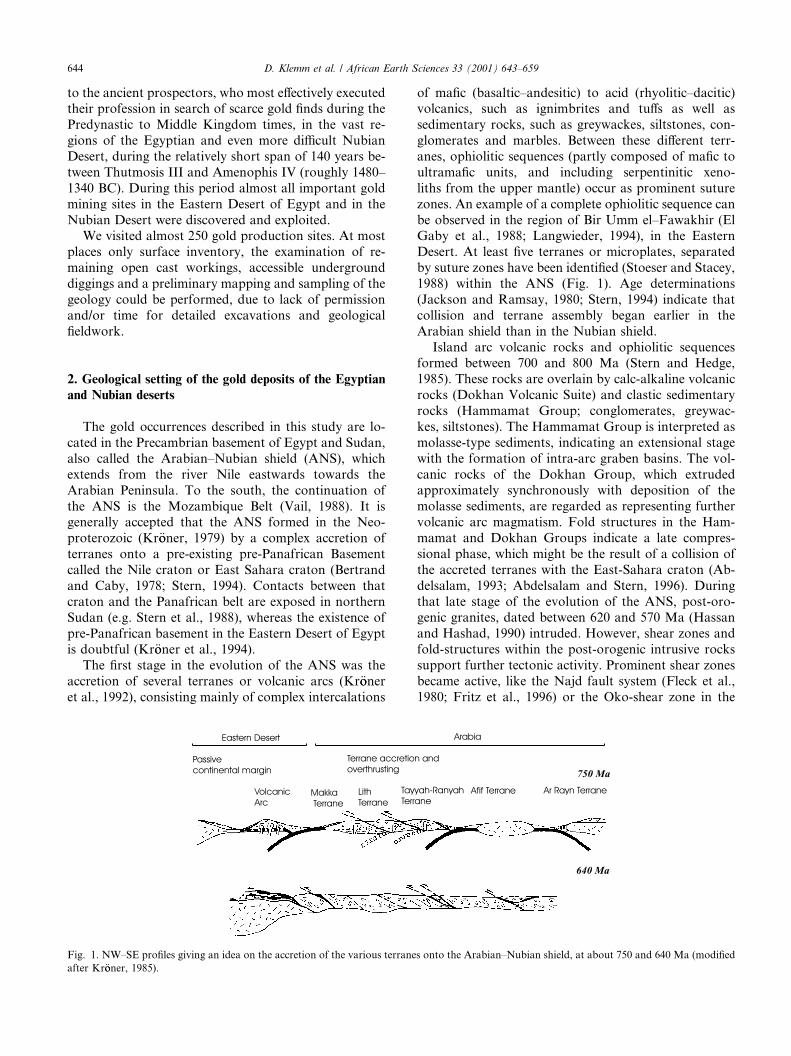
The gold occurrences described in this study are lo-cated in the Precambrian basement of Egypt and Sudan,also called the Arabian–Nubian shield (ANS), whichextends from the river Nile eastwards towards theArabian Peninsula. To the south, the continuation ofthe ANS is the Mozambique Belt (Vail, 1988). It isgenerally accepted that the ANS formed in the Neo-proterozoic (Kr€ooner, 1979) by a complex accretion ofterranes onto a pre-existing pre-Panafrican Basementcalled the Nile craton or East Sahara craton (Bertrandand Caby, 1978; Stern, 1994). Contacts between thatcraton and the Panafrican belt are exposed in northernSudan (e.g. Stern et al., 1988), whereas the existence ofpre-Panafrican basement in the Eastern Desert of Egyptis doubtful (Kr€ooner et al., 1994).The first stage in the evolution of the ANS was the
accretion of several terranes or volcanic arcs (Kr€ooneret al., 1992), consisting mainly of complex intercalations
of mafic (basaltic–andesitic) to acid (rhyolitic–dacitic)volcanics, such as ignimbrites and tuffs as well assedimentary rocks, such as greywackes, siltstones, con-glomerates and marbles. Between these different terr-anes, ophiolitic sequences (partly composed of mafic toultramafic units, and including serpentinitic xeno-liths from the upper mantle) occur as prominent suturezones. An example of a complete ophiolitic sequence canbe observed in the region of Bir Umm el–Fawakhir (ElGaby et al., 1988; Langwieder, 1994), in the EasternDesert. At least five terranes or microplates, separatedby suture zones have been identified (Stoeser and Stacey,1988) within the ANS (Fig. 1). Age determinations(Jackson and Ramsay, 1980; Stern, 1994) indicate thatcollision and terrane assembly began earlier in theArabian shield than in the Nubian shield.Island arc volcanic rocks and ophiolitic sequences
formed between 700 and 800 Ma (Stern and Hedge,1985). These rocks are overlain by calc-alkaline volcanicrocks (Dokhan Volcanic Suite) and clastic sedimentaryrocks (Hammamat Group; conglomerates, greywac-kes, siltstones). The Hammamat Group is interpreted asmolasse-type sediments, indicating an extensional stagewith the formation of intra-arc graben basins. The vol-canic rocks of the Dokhan Group, which extrudedapproximately synchronously with deposition of themolasse sediments, are regarded as representing furthervolcanic arc magmatism. Fold structures in the Ham-mamat and Dokhan Groups indicate a late compres-sional phase, which might be the result of a collision ofthe accreted terranes with the East-Sahara craton (Ab-delsalam, 1993; Abdelsalam and Stern, 1996). Duringthat late stage of the evolution of the ANS, post-oro-genic granites, dated between 620 and 570 Ma (Hassanand Hashad, 1990) intruded. However, shear zones andfold-structures within the post-orogenic intrusive rockssupport further tectonic activity. Prominent shear zonesbecame active, like the Najd fault system (Fleck et al.,1980; Fritz et al., 1996) or the Oko-shear zone in the
Fig. 1. NW–SE profiles giving an idea on the accretion of the various terranes onto the Arabian–Nubian shield, at about 750 and 640 Ma (modified
after Kr€ooner, 1985).
644 D. Klemm et al. / African Earth Sciences 33 (2001) 643–659
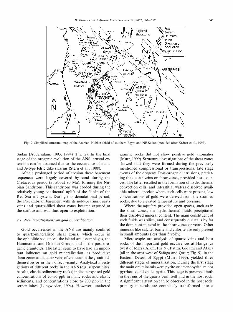
Sudan (Abdelsalam, 1993, 1994) (Fig. 2). In the finalstage of the orogenic evolution of the ANS, crustal ex-tension can be assumed due to the occurrence of maficand A-type felsic dike swarms (Stern et al., 1988).After a prolonged period of erosion these basement
sequences were largely covered by sand during theCretaceous period (at about 90 Ma), forming the Nu-bian Sandstone. This sandstone was eroded during therelatively young continental uplift of the flanks of theRed Sea rift system. During this denudational period,the Precambrian basement with its gold-bearing quartzveins and quartz-filled shear zones became exposed atthe surface and was thus open to exploitation.
2.1. New investigations on gold mineralization
Gold occurrences in the ANS are mainly confinedto quartz-mineralized shear zones, which occur inthe ophiolitic sequences, the island arc assemblages, theHammamat and Dokhan Groups and in the post-oro-genic granitoids. The latter seem to have had an impor-tant influence on gold mineralization, as productiveshear zones and quartz veins often occur in the granitoidsthemselves or in their direct vicinity. Analytical investi-gations of different rocks in the ANS (e.g. serpentinites,basalts, clastic sedimentary rocks) indicate exposed goldconcentrations of 20–50 ppb in mafic rocks and clasticsediments, and concentrations close to 200 ppb in theserpentinites (Langwieder, 1994). However, unaltered
granitic rocks did not show positive gold anomalies(Murr, 1999). Structural investigations of the shear zonesshowed that they were formed during the previouslymentioned compressional or transpressional late stageevents of the orogeny. Post-orogenic intrusions, predat-ing the quartz veins or shear zones, provided heat sour-ces. The latter resulted in the formation of hydrothermalconvection cells, and interstitial waters dissolved avail-able mineral species; where such cells were present, lowconcentrations of gold were derived from the strainedrocks, due to elevated temperature and pressure.Where the aquifers provided open spaces, such as in
the shear zones, the hydrothermal fluids precipitatedtheir dissolved mineral content. The main constituent ofsuch fluids was silica, and consequently quartz is by farthe dominant mineral in the shear zones or veins. Otherminerals like calcite, barite and chlorite are only presentin small amounts (less than 5 vol%).Microscopic ore analysis of quartz veins and host
rocks of the important gold occurrences at Hangaliya(west of Mersa Alam; Fig. 9), Fatira, Gidami and Atalla(all in the area west of Safaga and Qusir; Fig. 9), in theEastern Desert of Egypt (Murr, 1999), yielded threedifferent stages of mineralization. During the first stagethe main ore minerals were pyrite or arsenopyrite, minorpyrrhotite and chalcopyrite. This stage is preserved bothin the rims of the quartz vein itself and in the host rock.A significant alteration can be observed in the host rock:primary minerals are completely transformed into a
Fig. 2. Simplified structural map of the Arabian–Nubian shield of southern Egypt and NE Sudan (modified after Kr€ooner et al., 1992).
D. Klemm et al. / African Earth Sciences 33 (2001) 643–659 645
sericite–quartz–pyrite assemblage. A chemical compari-son between unaltered host rocks (e.g. granites) andtheir alteration products shows no significant change inthe composition for major elements. In particular, theFe-content remains the same although the pyrite/arsen-opyrite mineralization is evident. A chemical reaction ofa fluid (pH between 3.5 and 5) with the host rock canbe assumed, resulting in the formation of sericite andquartz. If gold was transported as a sulphide complex inthe reactive fluid, primary iron from the host rock andsulphide from the fluid could have formed pyrite whilethe gold was being precipitated. Gold was confinedwithin this first stage of mineralization mainly to pyriteor arsenopyrite.The second stage of mineralization can be observed
within the quartz veins. The main minerals are pyrite,sphalerite, galena and chalcopyrite, with minor amountsof digenite, hessite, calaverite, scheelite, hematite andtetraedrite. Gold occurs within quartz, sphalerite, ga-lena, pyrite and chalcopyrite. The third stage of miner-alization comprises mainly quartz; pyrite was rare and
gold was not found. Therefore this generation can beregarded as barren.Supergene alteration of the primary paragenesis re-
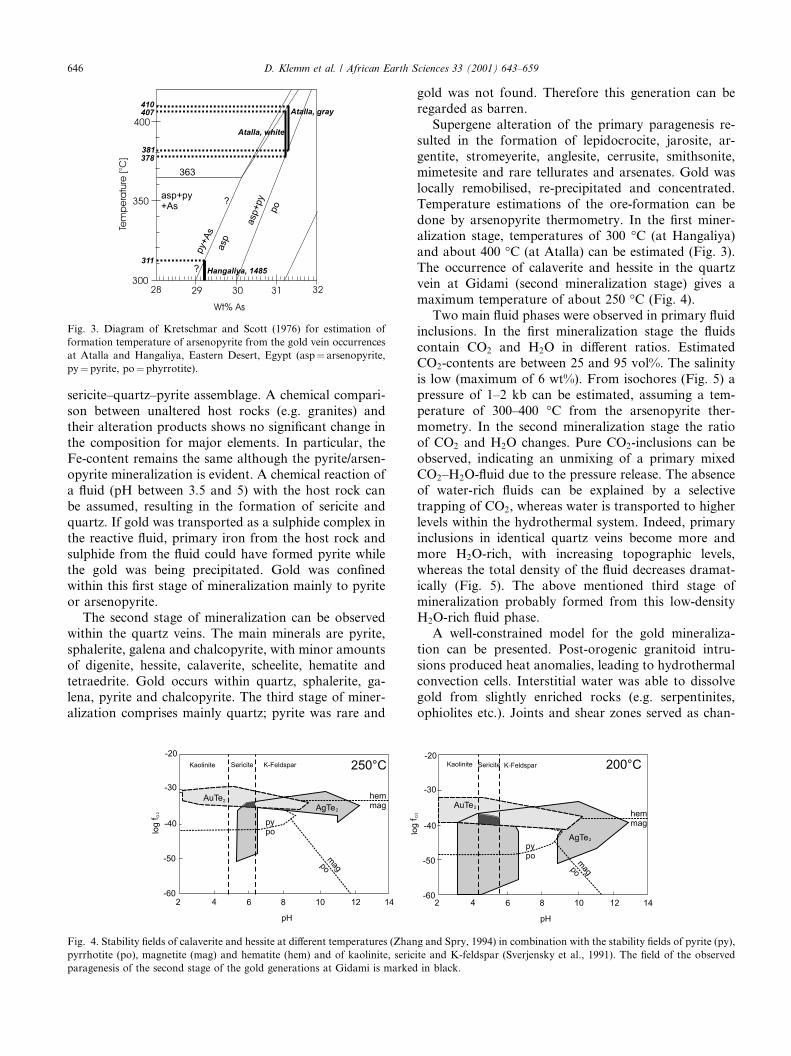
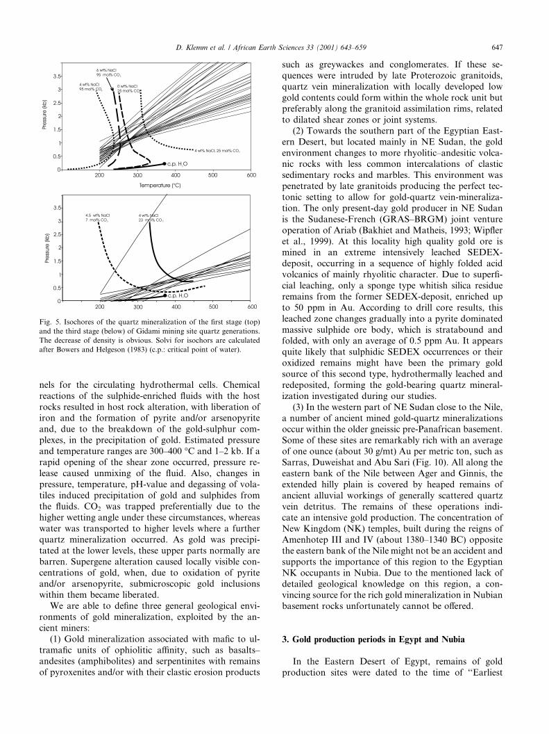
sulted in the formation of lepidocrocite, jarosite, ar-gentite, stromeyerite, anglesite, cerrusite, smithsonite,mimetesite and rare tellurates and arsenates. Gold waslocally remobilised, re-precipitated and concentrated.Temperature estimations of the ore-formation can bedone by arsenopyrite thermometry. In the first miner-alization stage, temperatures of 300 �C (at Hangaliya)and about 400 �C (at Atalla) can be estimated (Fig. 3).The occurrence of calaverite and hessite in the quartzvein at Gidami (second mineralization stage) gives amaximum temperature of about 250 �C (Fig. 4).Two main fluid phases were observed in primary fluid
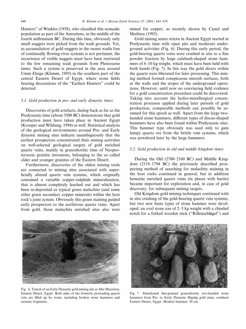
inclusions. In the first mineralization stage the fluidscontain CO2 and H2O in different ratios. EstimatedCO2-contents are between 25 and 95 vol%. The salinityis low (maximum of 6 wt%). From isochores (Fig. 5) apressure of 1–2 kb can be estimated, assuming a tem-perature of 300–400 �C from the arsenopyrite ther-mometry. In the second mineralization stage the ratioof CO2 and H2O changes. Pure CO2-inclusions can beobserved, indicating an unmixing of a primary mixedCO2–H2O-fluid due to the pressure release. The absenceof water-rich fluids can be explained by a selectivetrapping of CO2, whereas water is transported to higherlevels within the hydrothermal system. Indeed, primaryinclusions in identical quartz veins become more andmore H2O-rich, with increasing topographic levels,whereas the total density of the fluid decreases dramat-ically (Fig. 5). The above mentioned third stage ofmineralization probably formed from this low-densityH2O-rich fluid phase.A well-constrained model for the gold mineraliza-
tion can be presented. Post-orogenic granitoid intru-sions produced heat anomalies, leading to hydrothermalconvection cells. Interstitial water was able to dissolvegold from slightly enriched rocks (e.g. serpentinites,ophiolites etc.). Joints and shear zones served as chan-
Fig. 3. Diagram of Kretschmar and Scott (1976) for estimation of
formation temperature of arsenopyrite from the gold vein occurrences
at Atalla and Hangaliya, Eastern Desert, Egypt (asp¼ arsenopyrite,py¼ pyrite, po¼ phyrrotite).
Fig. 4. Stability fields of calaverite and hessite at different temperatures (Zhang and Spry, 1994) in combination with the stability fields of pyrite (py),
pyrrhotite (po), magnetite (mag) and hematite (hem) and of kaolinite, sericite and K-feldspar (Sverjensky et al., 1991). The field of the observed
paragenesis of the second stage of the gold generations at Gidami is marked in black.
646 D. Klemm et al. / African Earth Sciences 33 (2001) 643–659
nels for the circulating hydrothermal cells. Chemicalreactions of the sulphide-enriched fluids with the hostrocks resulted in host rock alteration, with liberation ofiron and the formation of pyrite and/or arsenopyriteand, due to the breakdown of the gold-sulphur com-plexes, in the precipitation of gold. Estimated pressureand temperature ranges are 300–400 �C and 1–2 kb. If arapid opening of the shear zone occurred, pressure re-lease caused unmixing of the fluid. Also, changes inpressure, temperature, pH-value and degassing of vola-tiles induced precipitation of gold and sulphides fromthe fluids. CO2 was trapped preferentially due to thehigher wetting angle under these circumstances, whereaswater was transported to higher levels where a furtherquartz mineralization occurred. As gold was precipi-tated at the lower levels, these upper parts normally arebarren. Supergene alteration caused locally visible con-centrations of gold, when, due to oxidation of pyriteand/or arsenopyrite, submicroscopic gold inclusionswithin them became liberated.We are able to define three general geological envi-
ronments of gold mineralization, exploited by the an-cient miners:(1) Gold mineralization associated with mafic to ul-
tramafic units of ophiolitic affinity, such as basalts–andesites (amphibolites) and serpentinites with remainsof pyroxenites and/or with their clastic erosion products
such as greywackes and conglomerates. If these se-quences were intruded by late Proterozoic granitoids,quartz vein mineralization with locally developed lowgold contents could form within the whole rock unit butpreferably along the granitoid assimilation rims, relatedto dilated shear zones or joint systems.(2) Towards the southern part of the Egyptian East-
ern Desert, but located mainly in NE Sudan, the goldenvironment changes to more rhyolitic–andesitic volca-nic rocks with less common intercalations of clasticsedimentary rocks and marbles. This environment waspenetrated by late granitoids producing the perfect tec-tonic setting to allow for gold-quartz vein-mineraliza-tion. The only present-day gold producer in NE Sudanis the Sudanese-French (GRAS–BRGM) joint ventureoperation of Ariab (Bakhiet and Matheis, 1993; Wipfleret al., 1999). At this locality high quality gold ore ismined in an extreme intensively leached SEDEX-deposit, occurring in a sequence of highly folded acidvolcanics of mainly rhyolitic character. Due to superfi-cial leaching, only a sponge type whitish silica residueremains from the former SEDEX-deposit, enriched upto 50 ppm in Au. According to drill core results, thisleached zone changes gradually into a pyrite dominatedmassive sulphide ore body, which is stratabound andfolded, with only an average of 0.5 ppm Au. It appearsquite likely that sulphidic SEDEX occurrences or theiroxidized remains might have been the primary goldsource of this second type, hydrothermally leached andredeposited, forming the gold-bearing quartz mineral-ization investigated during our studies.(3) In the western part of NE Sudan close to the Nile,
a number of ancient mined gold-quartz mineralizationsoccur within the older gneissic pre-Panafrican basement.Some of these sites are remarkably rich with an averageof one ounce (about 30 g/mt) Au per metric ton, such asSarras, Duweishat and Abu Sari (Fig. 10). All along theeastern bank of the Nile between Ager and Ginnis, theextended hilly plain is covered by heaped remains ofancient alluvial workings of generally scattered quartzvein detritus. The remains of these operations indi-cate an intensive gold production. The concentration ofNew Kingdom (NK) temples, built during the reigns ofAmenhotep III and IV (about 1380–1340 BC) oppositethe eastern bank of the Nile might not be an accident andsupports the importance of this region to the EgyptianNK occupants in Nubia. Due to the mentioned lack ofdetailed geological knowledge on this region, a con-vincing source for the rich gold mineralization in Nubianbasement rocks unfortunately cannot be offered.
3. Gold production periods in Egypt and Nubia
In the Eastern Desert of Egypt, remains of goldproduction sites were dated to the time of ‘‘Earliest
Fig. 5. Isochores of the quartz mineralization of the first stage (top)
and the third stage (below) of Gidami mining site quartz generations.
The decrease of density is obvious. Solvi for isochors are calculated
after Bowers and Helgeson (1983) (c.p.: critical point of water).
D. Klemm et al. / African Earth Sciences 33 (2001) 643–659 647
Hunters’’ of Winkler (1938), who classified this nomadicpopulation as part of the Amratiens, in the middle of thefourth millennium BC. During this time, obviously onlysmall nuggets were picked from the wadi grounds. Yet,as accumulation of gold nuggets in the recent wadis freeof continually flowing river systems is not pertinent, theoccurrence of visible nuggets must have been restrictedto the few remaining wadi grounds from Pleistocenetimes. Such a system is preserved in the area aroundUmm Eleiga (Klemm, 1995) in the southern part of thecentral Eastern Desert of Egypt, where stone fieldsbearing decorations of the ‘‘Earliest Hunters’’ could bedetected.
3.1. Gold production in pre- and early dynastic times
Discoveries of gold artefacts, dating back as far as thePredynastic time (about 3500 BC) demonstrate that goldproduction must have taken place in Ancient Egypt(Kroeper and Wildung, 1994) as well. Statistical analysisof the geological environments around Pre- and Earlydynastic mining sites indicate unambiguously that theearliest prospectors concentrated their mining activitieson well-selected geological targets of gold enrichedquartz veins, mainly in granodioritic rims of Neopro-terozoic granitic intrusions, belonging to the so calledolder and younger granites of the Eastern Desert.Furthermore, discoveries of the oldest mining tools
are connected to mining sites associated with super-ficially altered quartz vein systems, which originallycontained a variable copper-sulphide mineralization,that is almost completely leached out and which hasbeen re-deposited as typical green malachite (and someother green secondary copper minerals) within the hostrock’s joint system. Obviously this green staining guidedearly prospectors to the auriferous quartz veins. Apartfrom gold, those malachite enriched sites also were
mined for copper, as recently shown by Castel andMathieu (1992).Gold mining sensu strictu in Ancient Egypt started in
Predynastic time with open pits and moderate under-ground activities (Fig. 6). During this early period, thegold-bearing quartz veins were crushed in situ to a finepowder fraction by huge calabash-shaped stone ham-mers of 6–10 kg weight, which must have been held withboth hands (Fig. 7). In this way the gold slivers withinthe quartz were liberated for later processing. This min-ing method formed conspicuous smooth surfaces, bothat the walls and the stopes of the underground opera-tions. However, until now no convincing field evidencefor a gold concentration procedure could be discovered.Taking into account the hydro-metallurgical concen-tration processes applied during later periods of goldproduction, comparable methods can possibly be as-sumed for this epoch as well. Apart from the large two-handed stone hammers, different types of discus-shapedhammers have also been found within Predynastic sites.This hammer type obviously was used only to gainlumpy quartz ore from the brittle vein systems, whichwas powdered later by the large hammers.
3.2. Gold production in old and middle kingdom times
During the Old (2700–2160 BC) and Middle King-dom (2119–1794 BC) the previously described pros-pecting method of searching for malachite staining inthe host rocks continued in general, but in additionhematite enriched quartz veins (in places with barite)became important for exploration and, in case of golddiscovery, for subsequent mining targets.Old Kingdom gold mining techniques continued with
in situ crushing of the gold-bearing quartz vein systems,but two new basic types of stone hammer were devel-oped: an oval stone axe of 2–5 kg weight with a chiselednotch for a forked wooden stick (‘‘Rillenschl€aagel’’) and
Fig. 6. Trench of an Early Dynastic gold mining site at AbuMureiwat,
Eastern Desert, Egypt. Both sides of the formerly protruding quartz
vein are filled up by waste, including broken stone hammers and
ceramic fragments.
Fig. 7. Abandoned fine-grained granodioritic two-handed stone
hammers from Pre- to Early Dynastic Higalig gold mine, southern
Eastern Desert, Egypt. Modern hammer: 30 cm.
648 D. Klemm et al. / African Earth Sciences 33 (2001) 643–659
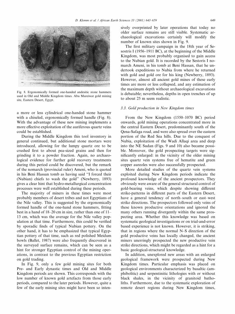
a more or less cylindrical one-handed stone hammerwith a chiseled, ergonomically formed handle (Fig. 8).With the advantage of these new mining implements amore effective exploitation of the auriferous quartz veinscould be established.During the Middle Kingdom this tool inventory in
general continued, but additional stone mortars wereintroduced, allowing for the lumpy quartz ore to becrushed first to about pea-sized grains and then forgrinding it to a powder fraction. Again, no archaeo-logical evidence for further gold recovery treatmentsduring this period could be discovered, but the remarkof the nomarch (provincial ruler) Ameni, who is quotedin his Beni Hassan tomb as having said ‘‘I forced their(Nubian) chiefs to wash the gold’’ (Newberry, 1893)gives a clear hint that hydro-metallurgical concentrationprocesses were well established during these periods.The majority of miners in these times were most
probably members of desert tribes and not Egyptians ofthe Nile valley. This is suggested by the ergonomicallyformed handle of the one-hand stone hammers, fittingbest in a hand of 18–20 cm in size, rather than one of 11–13 cm, which was the average for the Nile valley pop-ulation at that time. Furthermore, this could be verifiedby sporadic finds of typical Nubian pottery. On theother hand, it has to be emphasized that typical Egyp-tian pottery of that time, such as red polished Meidumbowls (Ballet, 1987) were also frequently discovered inthe surveyed surface remains, which can be seen as ahint for stronger Egyptian control of the mining oper-ations, in contrast to the previous Egyptian restrictionon gold trading.In Fig. 9, only a few gold mining sites for both
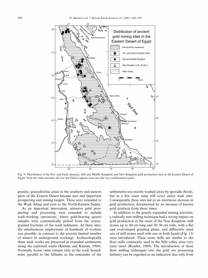
Pre- and Early dynastic times and Old and MiddleKingdom periods are shown. This corresponds with thelow number of known gold artefacts from those earlyperiods, compared to the later periods. However, quite afew of the early mining sites might have been so inten-
sively overprinted by later operations that today noolder surface remains are still visible. Systematic ar-chaeological excavations certainly will modify thenumber of known sites shown in Fig. 9.The first military campaign in the 18th year of Se-
sostris I (1956–1911 BC), at the beginning of the MiddleKingdom, was most probably organised to gain accessto the Nubian gold. It is recorded by the Sestoris I no-march Ameni, in his tomb at Beni Hassan, that he un-dertook expeditions to Nubia from where he returnedwith gold and gold ore for his king (Newberry, 1893).However, almost all ancient gold mines of these earlytimes are more or less collapsed, and any estimation ofthe maximum depth without archaeological excavationsis debatable; nevertheless, depths in open trenches of upto about 25 m seem realistic.
3.3. Gold production in New Kingdom times
From the New Kingdom (1550–1070 BC) periodonwards, gold mining operations concentrated more inthe central Eastern Desert, predominantly south of theQena-Safaga road, and were also spread over the easternportion of the Red Sea hills. Due to the conquest ofNubia, exploitation of the Wadi Allaqi area and deepinto the NE Sudan (Figs. 9 and 10) also became possi-ble. Moreover, the gold prospecting targets were sig-nificantly enlarged: in the vicinity of the older miningsites quartz vein systems free of hematite and greencopper aureoles were also successfully prospected.More detailed studies of the quartz vein systems
exploited during New Kingdom periods indicate theprofound knowledge of the ancient prospectors. Theyobviously were aware of the general structural control ofgold-bearing veins, which despite showing differentstrike-patterns in different parts of the Eastern Desert,have a general tendency of north–south or east–weststrike directions. The prospectors followed only veins ofthese known productive orientations and ignored themany others running divergently within the same pros-pecting area. Whether this knowledge was based onsystematic geological investigations or on trial-and-errorbased experience is not known. However, it is striking,that in regions where the normal N–S direction of thegold productive veins has locally changed, the ancientminers unerringly prospected the new productive veinstrike directions, which might be regarded as a hint for abasic geological-structural knowledge.In addition, unexplored new areas with an enlarged
geological framework were prospected during NewKingdom times. Particular emphasis was placed ongeological environments characterized by basaltic–(am-phibolitic) and serpentinitic lithologies with or withoutblack shales, in the vicinity of granitoid batho-liths. Furthermore, due to the systematic exploration ofremote desert regions during New Kingdom times,
Fig. 8. Ergonomically formed one-handed andesitic stone hammers
used in Old and Middle Kingdom times. Abu Mureiwat gold mining
site, Eastern Desert, Egypt.
D. Klemm et al. / African Earth Sciences 33 (2001) 643–659 649
granitic–granodioritic areas in the southern and easternparts of the Eastern Desert became new and importantprospecting and mining targets. These were extended tothe Wadi Allaqi and even to the North-Eastern Sudan.As an important innovation, intensive gold pros-
pecting and processing were extended to includewadi-working operations, where gold-bearing quartzsamples were systematically picked from the coarse-grained fractions of the wadi sediments. At these sites,the simultaneous employment of hundreds of workerswas possible, in contrast to the severely limited numberof miners in underground workings. Archaeologicallythese wadi works are preserved in extended settlementsalong the exploited wadis (Klemm and Klemm, 1994).Normally house ruins remain only at the wadi bound-aries, parallel to the hillsides as the remainder of the
settlements was mostly washed away by sporadic floods,but in a few cases ruins still cover entire wadi sites.Consequently these sites led to an enormous increase ingold production, documented by an increase of knowngold artefacts from those times.In addition to the greatly expanded mining activities,
a radically new milling technique had a strong impact ongold production at the onset of the New Kingdom: millstones up to 80 cm long and 30–50 cm wide, with a flatand oval-shaped grinding plane, and differently sizedsets of mill stones used with one or both hands (Fig. 11)were introduced. These stone mills are similar to theflour mills commonly used in the Nile valley since veryearly times (Roubet, 1989). The introduction of theseflour milling techniques into the gold ore processingindustry can be regarded as an indication that only from
Fig. 9. Distribution of the Pre- and Early dynastic, Old and Middle Kingdom and New Kingdom gold production sites in the Eastern Desert of
Egypt. Note the wide activities all over the Desert regions even into the very southernmost parts.
650 D. Klemm et al. / African Earth Sciences 33 (2001) 643–659
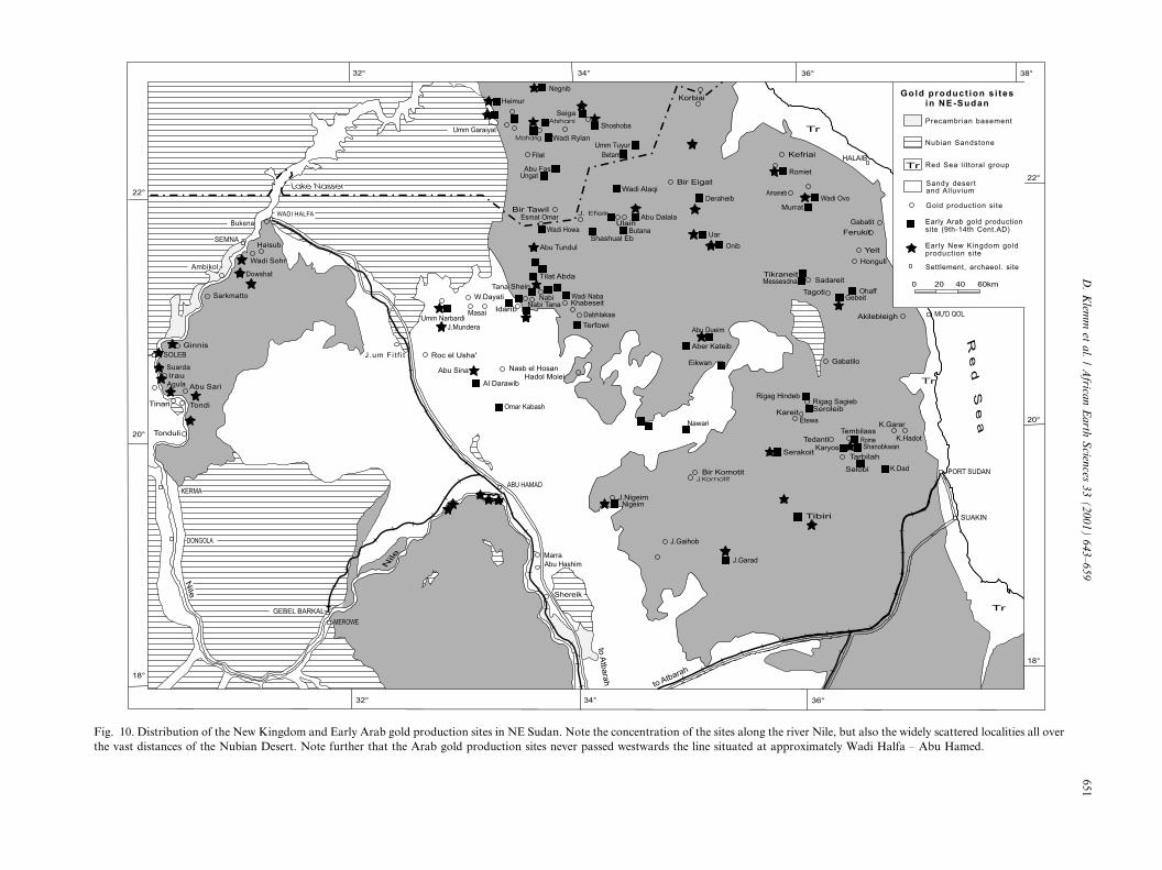
Fig. 10. Distribution of the New Kingdom and Early Arab gold production sites in NE Sudan. Note the concentration of the sites along the river Nile, but also the widely scattered localities all over
the vast distances of the Nubian Desert. Note further that the Arab gold production sites never passed westwards the line situated at approximately Wadi Halfa – Abu Hamed.
D.Klem
met
al./Africa
nEarth
Scien
ces33(2001)643–659
651
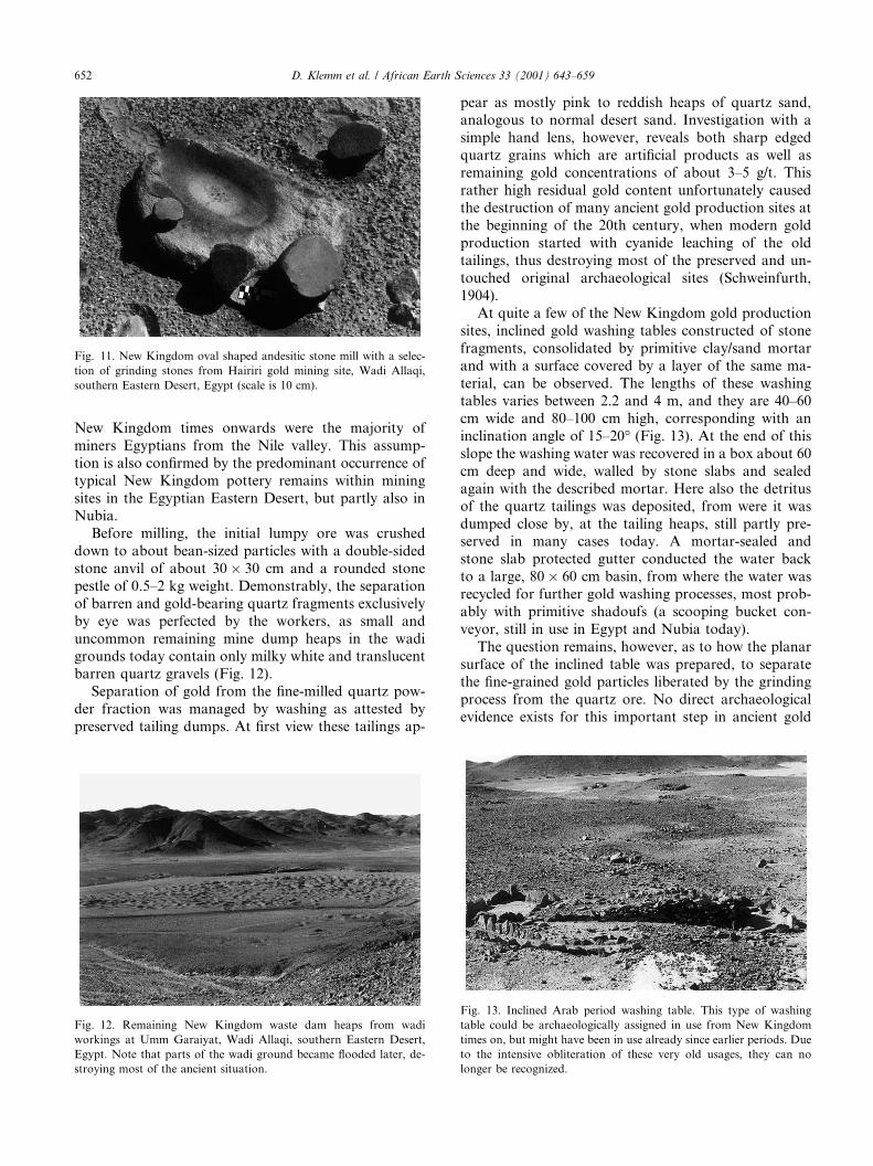
New Kingdom times onwards were the majority ofminers Egyptians from the Nile valley. This assump-tion is also confirmed by the predominant occurrence oftypical New Kingdom pottery remains within miningsites in the Egyptian Eastern Desert, but partly also inNubia.Before milling, the initial lumpy ore was crushed
down to about bean-sized particles with a double-sidedstone anvil of about 30� 30 cm and a rounded stonepestle of 0.5–2 kg weight. Demonstrably, the separationof barren and gold-bearing quartz fragments exclusivelyby eye was perfected by the workers, as small anduncommon remaining mine dump heaps in the wadigrounds today contain only milky white and translucentbarren quartz gravels (Fig. 12).Separation of gold from the fine-milled quartz pow-
der fraction was managed by washing as attested bypreserved tailing dumps. At first view these tailings ap-
pear as mostly pink to reddish heaps of quartz sand,analogous to normal desert sand. Investigation with asimple hand lens, however, reveals both sharp edgedquartz grains which are artificial products as well asremaining gold concentrations of about 3–5 g/t. Thisrather high residual gold content unfortunately causedthe destruction of many ancient gold production sites atthe beginning of the 20th century, when modern goldproduction started with cyanide leaching of the oldtailings, thus destroying most of the preserved and un-touched original archaeological sites (Schweinfurth,1904).At quite a few of the New Kingdom gold production
sites, inclined gold washing tables constructed of stonefragments, consolidated by primitive clay/sand mortarand with a surface covered by a layer of the same ma-terial, can be observed. The lengths of these washingtables varies between 2.2 and 4 m, and they are 40–60cm wide and 80–100 cm high, corresponding with aninclination angle of 15–20� (Fig. 13). At the end of thisslope the washing water was recovered in a box about 60cm deep and wide, walled by stone slabs and sealedagain with the described mortar. Here also the detritusof the quartz tailings was deposited, from were it wasdumped close by, at the tailing heaps, still partly pre-served in many cases today. A mortar-sealed andstone slab protected gutter conducted the water backto a large, 80� 60 cm basin, from where the water wasrecycled for further gold washing processes, most prob-ably with primitive shadoufs (a scooping bucket con-veyor, still in use in Egypt and Nubia today).The question remains, however, as to how the planar
surface of the inclined table was prepared, to separatethe fine-grained gold particles liberated by the grindingprocess from the quartz ore. No direct archaeologicalevidence exists for this important step in ancient gold
Fig. 12. Remaining New Kingdom waste dam heaps from wadi
workings at Umm Garaiyat, Wadi Allaqi, southern Eastern Desert,
Egypt. Note that parts of the wadi ground became flooded later, de-
stroying most of the ancient situation.
Fig. 13. Inclined Arab period washing table. This type of washing
table could be archaeologically assigned in use from New Kingdom
times on, but might have been in use already since earlier periods. Due
to the intensive obliteration of these very old usages, they can no
longer be recognized.
Fig. 11. New Kingdom oval shaped andesitic stone mill with a selec-
tion of grinding stones from Hairiri gold mining site, Wadi Allaqi,
southern Eastern Desert, Egypt (scale is 10 cm).
652 D. Klemm et al. / African Earth Sciences 33 (2001) 643–659
recovery. Due to the lack of any archaeological relicts inthis respect it might be assumed that the covers of theseinclined tables were of organic materials. Here in generaltwo possibilities are likely, either a wooden grid orsimply sheepskins, as both were commonly used in themore recent past for separation of gold slivers andquartz sand fractions. The sheepskin hypothesis is sup-ported by the supposition that sheep were available atthe mining sites as food, and further, both the lanolin-grease and the washed fibers of the sheepskins wouldhave trapped the sharp-edged gold particles whereas thebarren quartz particles were carried off with the watersuspension. The legend of the Golden Fleece, therefore,may have been of Egyptian origin and of far greaterantiquity than the voyage of the Argonauts. Finally,burning the pelts containing the gold particles yields araw gold product, but obviously no witness to this lastpossible step of the gold recovery procedure would re-main.
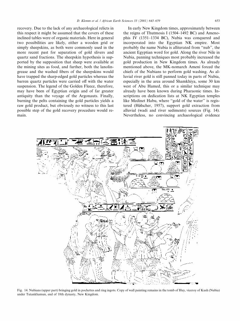
In early New Kingdom times, approximately betweenthe reigns of Thutmosis I (1504–1492 BC) and Ameno-phis IV (1351–1334 BC), Nubia was conquered andincorporated into the Egyptian NK empire. Mostprobably the name Nubia is alliterated from ‘‘nub’’, theancient Egyptian word for gold. Along the river Nile inNubia, panning techniques most probably increased thegold production in New Kingdom times. As alreadymentioned above, the MK-nomarch Ameni forced thechiefs of the Nubians to perform gold washing. As al-luvial river gold is still panned today in parts of Nubia,especially in the area around Shamkhiya, some 30 kmwest of Abu Hamed, this or a similar technique mayalready have been known during Pharaonic times. In-scriptions on dedication lists at NK Egyptian templeslike Medinet Habu, where ‘‘gold of the water’’ is regis-tered (H€oolscher, 1957), support gold extraction fromalluvial (wadi and river sediments) sources (Fig. 14).Nevertheless, no convincing archaeological evidence
Fig. 14. Nubians (upper part) bringing gold in pochettes and ring ingots. Copy of wall painting remains in the tomb of Huy, viceroy of Kush (Nubia)
under Tutankhamun, end of 18th dynasty, New Kingdom.
D. Klemm et al. / African Earth Sciences 33 (2001) 643–659 653
exists for panning or equivalent techniques having beenapplied during Pharaonic periods. The unique, probablegold washing plant reported by Vercoutter (1959) fromthe vicinity of Faras (now under the water of LakeSudan), is doubtful, as the author himself was puzzledwhether this could not possibly have been an installationfor wine production.The well-organized housing areas of the various gold
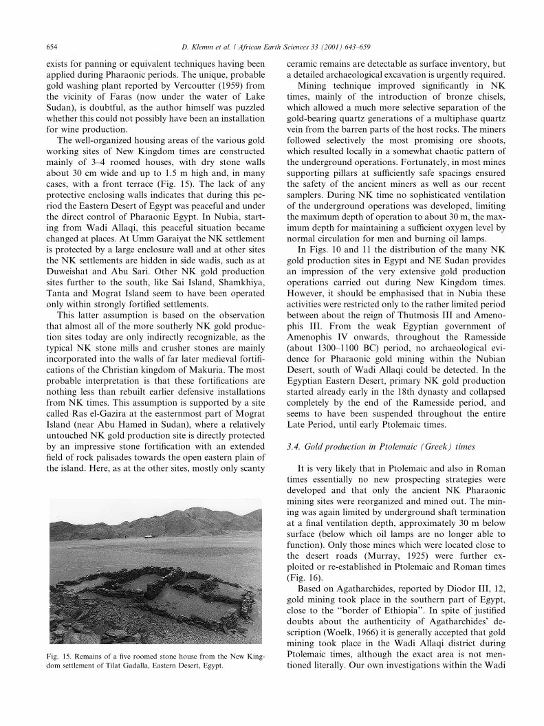
working sites of New Kingdom times are constructedmainly of 3–4 roomed houses, with dry stone wallsabout 30 cm wide and up to 1.5 m high and, in manycases, with a front terrace (Fig. 15). The lack of anyprotective enclosing walls indicates that during this pe-riod the Eastern Desert of Egypt was peaceful and underthe direct control of Pharaonic Egypt. In Nubia, start-ing from Wadi Allaqi, this peaceful situation becamechanged at places. At Umm Garaiyat the NK settlementis protected by a large enclosure wall and at other sitesthe NK settlements are hidden in side wadis, such as atDuweishat and Abu Sari. Other NK gold productionsites further to the south, like Sai Island, Shamkhiya,Tanta and Mograt Island seem to have been operatedonly within strongly fortified settlements.This latter assumption is based on the observation
that almost all of the more southerly NK gold produc-tion sites today are only indirectly recognizable, as thetypical NK stone mills and crusher stones are mainlyincorporated into the walls of far later medieval fortifi-cations of the Christian kingdom of Makuria. The mostprobable interpretation is that these fortifications arenothing less than rebuilt earlier defensive installationsfrom NK times. This assumption is supported by a sitecalled Ras el-Gazira at the easternmost part of MogratIsland (near Abu Hamed in Sudan), where a relativelyuntouched NK gold production site is directly protectedby an impressive stone fortification with an extendedfield of rock palisades towards the open eastern plain ofthe island. Here, as at the other sites, mostly only scanty
ceramic remains are detectable as surface inventory, buta detailed archaeological excavation is urgently required.Mining technique improved significantly in NK
times, mainly of the introduction of bronze chisels,which allowed a much more selective separation of thegold-bearing quartz generations of a multiphase quartzvein from the barren parts of the host rocks. The minersfollowed selectively the most promising ore shoots,which resulted locally in a somewhat chaotic pattern ofthe underground operations. Fortunately, in most minessupporting pillars at sufficiently safe spacings ensuredthe safety of the ancient miners as well as our recentsamplers. During NK time no sophisticated ventilationof the underground operations was developed, limitingthe maximum depth of operation to about 30 m, the max-imum depth for maintaining a sufficient oxygen level bynormal circulation for men and burning oil lamps.In Figs. 10 and 11 the distribution of the many NK
gold production sites in Egypt and NE Sudan providesan impression of the very extensive gold productionoperations carried out during New Kingdom times.However, it should be emphasised that in Nubia theseactivities were restricted only to the rather limited periodbetween about the reign of Thutmosis III and Ameno-phis III. From the weak Egyptian government ofAmenophis IV onwards, throughout the Ramesside(about 1300–1100 BC) period, no archaeological evi-dence for Pharaonic gold mining within the NubianDesert, south of Wadi Allaqi could be detected. In theEgyptian Eastern Desert, primary NK gold productionstarted already early in the 18th dynasty and collapsedcompletely by the end of the Ramesside period, andseems to have been suspended throughout the entireLate Period, until early Ptolemaic times.
3.4. Gold production in Ptolemaic (Greek) times
It is very likely that in Ptolemaic and also in Romantimes essentially no new prospecting strategies weredeveloped and that only the ancient NK Pharaonicmining sites were reorganized and mined out. The min-ing was again limited by underground shaft terminationat a final ventilation depth, approximately 30 m belowsurface (below which oil lamps are no longer able tofunction). Only those mines which were located close tothe desert roads (Murray, 1925) were further ex-ploited or re-established in Ptolemaic and Roman times(Fig. 16).Based on Agatharchides, reported by Diodor III, 12,
gold mining took place in the southern part of Egypt,close to the ‘‘border of Ethiopia’’. In spite of justifieddoubts about the authenticity of Agatharchides’ de-scription (Woelk, 1966) it is generally accepted that goldmining took place in the Wadi Allaqi district duringPtolemaic times, although the exact area is not men-tioned literally. Our own investigations within the Wadi
Fig. 15. Remains of a five roomed stone house from the New King-
dom settlement of Tilat Gadalla, Eastern Desert, Egypt.
654 D. Klemm et al. / African Earth Sciences 33 (2001) 643–659
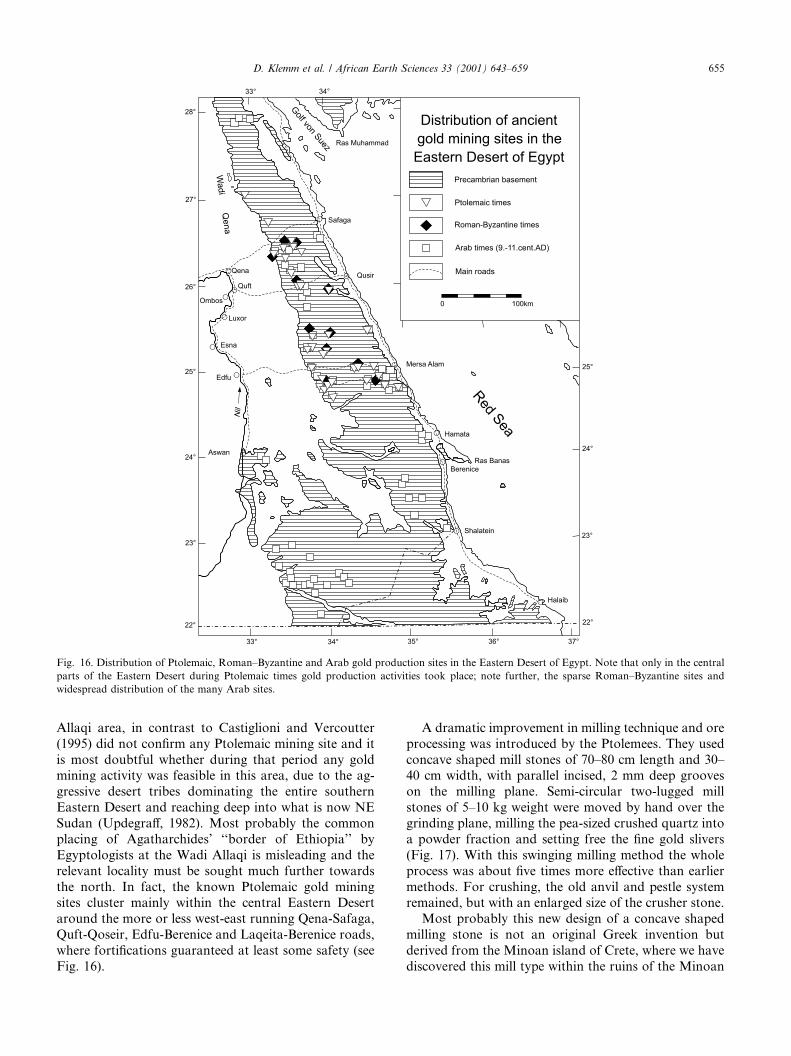
Allaqi area, in contrast to Castiglioni and Vercoutter(1995) did not confirm any Ptolemaic mining site and itis most doubtful whether during that period any goldmining activity was feasible in this area, due to the ag-gressive desert tribes dominating the entire southernEastern Desert and reaching deep into what is now NESudan (Updegraff, 1982). Most probably the commonplacing of Agatharchides’ ‘‘border of Ethiopia’’ byEgyptologists at the Wadi Allaqi is misleading and therelevant locality must be sought much further towardsthe north. In fact, the known Ptolemaic gold miningsites cluster mainly within the central Eastern Desertaround the more or less west-east running Qena-Safaga,Quft-Qoseir, Edfu-Berenice and Laqeita-Berenice roads,where fortifications guaranteed at least some safety (seeFig. 16).
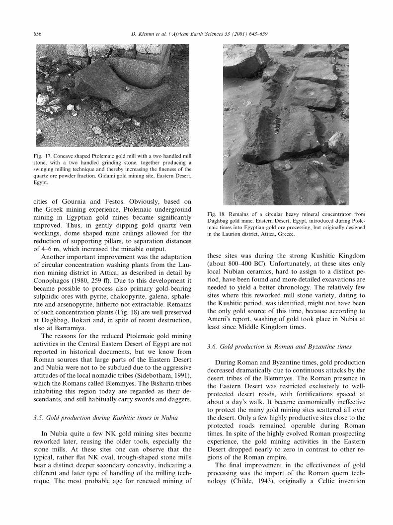
A dramatic improvement in milling technique and oreprocessing was introduced by the Ptolemees. They usedconcave shaped mill stones of 70–80 cm length and 30–40 cm width, with parallel incised, 2 mm deep grooveson the milling plane. Semi-circular two-lugged millstones of 5–10 kg weight were moved by hand over thegrinding plane, milling the pea-sized crushed quartz intoa powder fraction and setting free the fine gold slivers(Fig. 17). With this swinging milling method the wholeprocess was about five times more effective than earliermethods. For crushing, the old anvil and pestle systemremained, but with an enlarged size of the crusher stone.Most probably this new design of a concave shaped
milling stone is not an original Greek invention butderived from the Minoan island of Crete, where we havediscovered this mill type within the ruins of the Minoan
Fig. 16. Distribution of Ptolemaic, Roman–Byzantine and Arab gold production sites in the Eastern Desert of Egypt. Note that only in the central
parts of the Eastern Desert during Ptolemaic times gold production activities took place; note further, the sparse Roman–Byzantine sites and
widespread distribution of the many Arab sites.
D. Klemm et al. / African Earth Sciences 33 (2001) 643–659 655
cities of Gournia and Festos. Obviously, based onthe Greek mining experience, Ptolemaic undergroundmining in Egyptian gold mines became significantlyimproved. Thus, in gently dipping gold quartz veinworkings, dome shaped mine ceilings allowed for thereduction of supporting pillars, to separation distancesof 4–6 m, which increased the minable output.Another important improvement was the adaptation
of circular concentration washing plants from the Lau-rion mining district in Attica, as described in detail byConophagos (1980, 259 ff). Due to this development itbecame possible to process also primary gold-bearingsulphidic ores with pyrite, chalcopyrite, galena, sphale-rite and arsenopyrite, hitherto not extractable. Remainsof such concentration plants (Fig. 18) are well preservedat Daghbag, Bokari and, in spite of recent destruction,also at Barramiya.The reasons for the reduced Ptolemaic gold mining
activities in the Central Eastern Desert of Egypt are notreported in historical documents, but we know fromRoman sources that large parts of the Eastern Desertand Nubia were not to be subdued due to the aggressiveattitudes of the local nomadic tribes (Sidebotham, 1991),which the Romans called Blemmyes. The Bisharin tribesinhabiting this region today are regarded as their de-scendants, and still habitually carry swords and daggers.
3.5. Gold production during Kushitic times in Nubia
In Nubia quite a few NK gold mining sites becamereworked later, reusing the older tools, especially thestone mills. At these sites one can observe that thetypical, rather flat NK oval, trough-shaped stone millsbear a distinct deeper secondary concavity, indicating adifferent and later type of handling of the milling tech-nique. The most probable age for renewed mining of
these sites was during the strong Kushitic Kingdom(about 800–400 BC). Unfortunately, at these sites onlylocal Nubian ceramics, hard to assign to a distinct pe-riod, have been found and more detailed excavations areneeded to yield a better chronology. The relatively fewsites where this reworked mill stone variety, dating tothe Kushitic period, was identified, might not have beenthe only gold source of this time, because according toAmeni’s report, washing of gold took place in Nubia atleast since Middle Kingdom times.
3.6. Gold production in Roman and Byzantine times
During Roman and Byzantine times, gold productiondecreased dramatically due to continuous attacks by thedesert tribes of the Blemmyes. The Roman presence inthe Eastern Desert was restricted exclusively to well-protected desert roads, with fortifications spaced atabout a day’s walk. It became economically ineffectiveto protect the many gold mining sites scattered all overthe desert. Only a few highly productive sites close to theprotected roads remained operable during Romantimes. In spite of the highly evolved Roman prospectingexperience, the gold mining activities in the EasternDesert dropped nearly to zero in contrast to other re-gions of the Roman empire.The final improvement in the effectiveness of gold
processing was the import of the Roman quern tech-nology (Childe, 1943), originally a Celtic invention
Fig. 18. Remains of a circular heavy mineral concentrator from
Daghbag gold mine, Eastern Desert, Egypt, introduced during Ptole-
maic times into Egyptian gold ore processing, but originally designed
in the Laurion district, Attica, Greece.
Fig. 17. Concave shaped Ptolemaic gold mill with a two handled mill
stone, with a two handled grinding stone, together producing a
swinging milling technique and thereby increasing the fineness of the
quartz ore powder fraction. Gidami gold mining site, Eastern Desert,
Egypt.
656 D. Klemm et al. / African Earth Sciences 33 (2001) 643–659
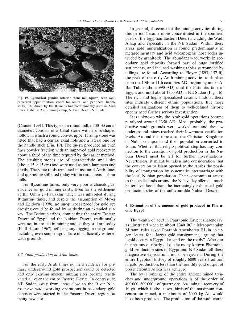
(Cauuet, 1991). This type of a round mill, of 30–45 cm indiameter, consists of a basal stone with a disc-shapedhollow in which a round convex upper turning stone wasfitted that had a central axial hole and a lateral one forthe handle stick (Fig. 19). The quern produced an evenfiner powder fraction with an improved gold recovery inabout a third of the time required by the earlier method.The crushing stones are of characteristic small size(about 15� 15 cm) and were used as both hammers andanvils. The same tools remained in use until Arab timesand querns are still used today within rural areas as flourmills.For Byzantine times, only very poor archaeological
evidence for gold mining exists. Even for the settlementat Bir Umm el–Fawakhir which was inhabited duringByzantine times, and despite the assumption of Meyerand Heidorn (1998), no unequivocal proof for gold oredressing could be found by us during an extended sur-vey. The Bedouin tribes, dominating the entire EasternDesert of Egypt and the Nubian Desert, traditionallywere not interested in mining and so they still are today(Fadl Hasan, 1967), refusing any digging in the ground,including even simple agriculture in sufficiently wateredwadi grounds.
3.7. Gold production in Arab times
For the early Arab times no field evidence for pri-mary underground gold prospection could be detectedand only existing ancient mining sites became reacti-vated all over the entire Eastern Desert. In contrast, inNE Sudan away from areas close to the River Nile,extensive wadi working operations in secondary golddeposits were started in the Eastern Desert regions atmany new sites.
In general, it seems that the mining activities duringthis period became more concentrated in the southernparts of the Egyptian Eastern Desert including the WadiAllaqi and especially in the NE Sudan. Within theseareas gold mineralization is found predominantly inmetasedimentary and acid volcanogenic host rocks in-truded by granitoids. The abundant wadi works in sec-ondary gold deposits formed part of huge fortifiedsettlements, and inclined washing tables surrounded bytailings are found. According to Floyer (1893, 157 ff),the peak of the early Arab mining activities took placefrom the 10th to 11th centuries AD, beginning under A.Ibn Tulun (about 990 AD) until the Fatimitic time inEgypt, and until about 1350 AD in NE Sudan (Fig. 16).The rich and highly specialized ceramic finds at thesesites indicate different ethnic populations. But moredetailed assignations of them to well-defined historicepochs need further serious investigation.It is unknown why the Arab gold operations became
paralyzed around 1350 AD. Most probably, the pro-ductive wadi grounds were worked out and the fewunderground mines reached their lowermost ventilationlevels. Around this time also, the Christian Kingdomsin Nubia collapsed and their population converted toIslam. Whether this religio-political step has any con-nection to the cessation of gold production in the Nu-bian Desert must be left for further investigations.Nevertheless, it might be taken into consideration thatthe conversion to Islam opened to the Arabs the possi-bility of immigration by systematic intermarriage withthe local Nubian population. Their concomitant accessto the fertile lands around the Nile valley offered a muchbetter livelihood than the increasingly exhausted goldproduction sites of the unfavourable Nubian Desert.
4. Estimation of the amount of gold produced in Phara-onic Egypt
The wealth of gold in Pharaonic Egypt is legendary,as illustrated when in about 1340 BC a MesopotamianMitanni ruler asked Pharaoh Amenhotep III, in an ur-gent letter, for a larger gold consignment, arguing that‘‘gold occurs in Egypt like sand on the roads’’. After ourinspections of nearly all of the many known Pharaonicgold production sites in Egypt and NE Sudan all theseimaginative expectations must be rejected. During theentire Egyptian history of roughly 6000 years traditionin gold production, less than the monthly gold output ofpresent South Africa was achieved.The total tonnage of the entire ancient mined tren-
ches and underground operations is of the order of400 000–600 000 t of quartz ore. Assuming a recovery of10 g/t, which is about two thirds of the maximum con-centration mined, a maximum of 6000 kg Au wouldhave been produced. The production of the wadi works
Fig. 19. Cylindrical granitic rotation stone mill (quern) with well-
preserved upper rotation stones for central and peripheral handle
sticks, introduced by the Romans but predominantly used in Arab
times. Gabatilo Arab mining camp, Nubian Desert, NE Sudan.
D. Klemm et al. / African Earth Sciences 33 (2001) 643–659 657
is far more problematic to estimate, but might have beenof the same order, or maximally double. This results in amaximum total gold production of 18 t. Roughly 40% ofthis gold was gained during Pharaonic times, yieldingaround 7 t Au. The rest is equally distributed betweenboth Ptolemaic and Arab times, neglecting the very lowproduction rates of Predynastic and Roman–Byzantinetimes.This estimation, of course, does not correspond with
the expectations of archaeologists when projecting thegold inventory of untouched tombs, like the one ofTutankhamun, and inferred from royal dedication listsin temples from the entire Pharaonic history. The onlysolution to this discrepancy might be seen in intensiverecycling of gold more or less constantly throughoutthe Pharaonic history, but with an increasing tendencyfrom about the 12th century BC on. The famous tombrobbery papyrus (Caminos, 1977) gives an impression ofthe destitution of justice and of implicit governmentalagreement to these robberies, presumably also necessaryfor the supply of the public gold demand.
Acknowledgements
We wish to express our deepest thanks to EGSMA,especially Dr. Abu Bakr Hawari, and to GRAS, par-ticularly to its General Director, Dr. Moh. Omer Kheir,and to the two GRAS-geologists Mohamed el-HagHassan and Mustafa Kasim, who accompanied us dur-ing our desert trips in NE-Sudan. Furthermore, we owea great debt to our German students, Axel Kraus,Gernot Langwieder, Ruppert Utz, Markus Lang, Chris-tian Tichatschke and Florian Schmid, who suffered withus on different field trips in Egypt and Sudan the manyprivations but also enjoyments of the remote regions.Mrs. Heide Felske helped with the drawings of themaps. Last but not least, the generous financial supportof the German Volkswagen-Foundation is gratefullyacknowledged.
References
Abdelsalam, M.G., 1993. Structural evolution of the Oko Shear Zone,
Sudan. In: Thorweihe, U., Schandelmeier, H. (Eds.), Geoscientific
Research in Northeast Africa. A.A. Balkema, Rotterdam/Brook-
field, pp. 121–125.
Abdelsalam, M.G., 1994. The Oko Shear Zone: post-accretionary
deformations in the Arabian–Nubian shield. J. African Earth Sci.
151, 767–776.
Abdelsalam, M.G., Stern, R.J., 1996. Sutures and shear zones in the
Arabian–Nubian shield. J. African Earth Sci. 23/3, 289–310.
Bakhiet, A.K., Matheis, G., 1993. Gold productive volcanogenic
sulphide mineralization in the Ariab Belt, Red Sea Hills/Sudan:
evidences for late proterozoic seafloor hydrothermal systems. In:
Thorweihe, U., Schandelmeier, H. (Eds.), Geoscientific Research in
Northeast Africa. A.A. Balkema, Rotterdam/Brookfield, pp. 533–
540.
Ballet, P., 1987. Essai de classification de coupes Type Maidum-Bowl.
Cahiers de la ceramique Egyptienne, tome 1, Le Caire, 1–16.
Bertrand, J.M.L., Caby, R., 1978. Geodynamic evolution of the Pan-
African orogenic belt; a new interpretation of the Hoggar shield
(Algerian Sahara). Geol. Rundsch. 67 (2), 357–388.
Bowers, T.S., Helgeson, H.C., 1983. Calculation of the thermodynamic
and geochemical consequences of non ideal mixing in the system
H2O–CO2–NaCl on phase relations in geologic systems: equation
of state for H2O–CO2–NaCl fluids at high pressures and temper-
atures. Geochim. Cosmochim. Acta 47 (7), 1247–1275.
Caminos, R.A., 1977. Grabr€aauberprozess, Lex. €AAgyptol., Bd. 2, 862–
866.
Castel, G., Mathieu, B., 1992. Les mines de cuivre du Wadi Dara. In:
BIFAO, vol. 92, pp. 51–65.
Castiglioni, A., Vercoutter, J., 1995. Das Goldland der Pharaonen.
Mainz.
Cauuet, B., 1991. L’exploitation de l’or en Limousin des Gaulois aux
Gallo-Romains. In: Annales du Midi, Toulouse, t. 103(194), pp.
149–181.
Childe, V.G., 1943. Rotary querns on the Continent and the
Mediterranian basin. Antiquity 17, 19–26, London.
Conophagos, C., 1980. Le Laurium Antique et la technique Greque de
la production de l’argent. Athens.
El Gaby, S., List, F.K., Tehrani, R., 1988. Geology, evolution and
metallogenesis of the Pan African Belt in Egypt. In: El-Gaby, S.,
Greiling, R.O. (Eds.), The Pan African Belt of Northeast Africa
and Adjacent Areas. Vieweg, Braunschweig, pp. 17–63.
Fadl Hasan, Y., 1967. In: The Arabs and the Sudan. University Press,
Edinburgh, 298 pp.
Fleck, R.J., Greenwood, W.R., Hadley, D.G., Anderson, R.E.,
Schmidt, D.L., 1980. Rubidium–strontium geochronology and
plate-tectonic evolution of the southern part of the Arabian shield.
US Geol. Surv. Prof. Paper 1131, 38 pp.
Floyer, E.A., 1893. �EEtude sur le Nord-Etbai entre le Nil et le Mer
Rouge, Le Caire.
Fritz, H., Wallbrecher, E., Khudeir, A.A., Abu El Ela, F., Dallmeyer,
D.R., 1996. Formation of neoproterozoic metamorphic core
complexes during oblique convergence (Eastern Desert Egypt). J.
African Earth Sci. 23/3, 311–329.
Hassan, M.A., Hashad, A.H., 1990. Precambrian of Egypt. In: Said,
R. (Ed.), The Geology of Egypt. A.A. Balkema, Rotterdam/
Brookfield, pp. 201–245.
H€oolscher, U., 1957. University of Chicago Orient. Inst. Publ., vol. 83:Medinet Habu, vol. 5, The Temple proper Part I: pl. 328. Chicago.
Jackson, N.J., Ramsay, C.R., 1980. Time-space relationships of upper
Precambrian volcanic and sedimentary units in the central Arabian
shield. J. Geol. Soc., London 137 (5), 617–628.
Klemm, R., 1995. Umm Eleiga Ein pr€aadynastischer Goldfundplatz in
der Ostw€uuste €AAgyptens. M€uunchener €AAgyptol. Unters. 4, 247–260,
Peter Lang Verlag, Frankfurt.
Klemm, R., Klemm, D., 1994. Chronologischer Abriss der antiken
Goldgewinnung in der Ostw€uuste €AAgyptens. Mitt. Deutsch. Arch-€aaolog. Inst. Kairo Band 50, 189–222.
Kretschmar, U., Scott, S.D., 1976. Phase relations involving arseno-
pyrite in the system Fe–As–S and their application. Can. Mineral.
14 (3), 364–368.
Kr€ooner, A., 1979. Pan-African plate tectonics and its repercussions on
the crust of north-east Africa. Geol. Rundsch. 68, 565–583.
Kr€ooner, A., 1985. Ophiolites and the evolution of tectonic boundaries
in the late Proterozoic Arabian–Nubian shield of Northeast Africa
and Arabia. Precamb. Res. 27 (1-3), 277–300.
Kr€ooner, A., Todt, W., Hussein, I.M., Mansour, M., Rashwan, A.A.,1992. Dating of late proterozoic ophiolithes in Egypt and Sudan
using the single grain zircon evaporation technique. Precamb. Res.
59 (1–2), 15–32.
658 D. Klemm et al. / African Earth Sciences 33 (2001) 643–659
Kr€ooner, A., Kr€uuger, J., Rashwan, A.A.A., 1994. Age and tectonicsetting of granitoid gneisses in the eastern desert of Egypt and
south-west Sinai. Geol. Rundsch. 83 (3), 502–513.
Kroeper, K., Wildung D., 1994. Minshat Abu Omar I, Mainz, p. 162
with pl. 44.
Langwieder, G., 1994. Die Geologie des Gebietes Wadi El-Sid/Um el
Fawakhir und Geochemische Untersuchungen an Quarzg€aangen des
Goldlagerst€aattenbezirkes El Sid/Fawakhir. Unpublished M.Sc.
Thesis, Ludwig-Maximilians-Universit€aat M€uunchen, 122 p.
Meyer, C., Heidorn, L., 1998. Three seasons at Bir Umm Fawakhir in
the Central Eastern Desert. In: Kaper, O.E. (Ed.), Life on the
Fringe. Research School CNWS, Leiden, pp. 197–209.
Murr, A., 1999. Die Genese der Goldlagerst€aattenbezirke Fatira, Gid-
ami Atalla und Hangaliya in der €AAgyptischen Ostw€uuste. M€uunchner
Geol. Hefte A 27, 202.
Murray, G.W., 1925. The Roman roads and stations in the Eastern
Desert of Egypt. JEA 11, 138–150.
Newberry, P.E., 1893. Beni Hassan I. Arch. Surv. Egypt (ASE) 1, pl. 8.
London.
Roubet, C., 1989. The grinding stones of site E-78-3 Wadi Kubbaniye.
In: Wendorf, F. (Ed.), The Prehistory of Wadi Kubbaniye, vol. III.
Southern Methodist University Press, Dallas, pp. 473–489.
Schweinfurth, G., 1904. Die Wiederaufnahme des alten Goldminen-
Betriebs in €AAgypten und Nubien. Ann. Service Antiquit. Egypt 4,
268–280.
Sidebotham, S.E., 1991. R€oomische Straßen in der €AAgyptischen W€uuste.
In: Antike Welt 22.Jg, 3, pp. 177–189.
Stern, R.J., 1994. Arc assembly and continental collision in the Neo-
proterozoic east African Orogen: implication for the consolidation
of Gondwanaland. Ann. Rev. Earth Planet. Sci. 22, 319–351.
Stern, R.J., Hedge, C.E., 1985. Geochronologic and isotopic con-
straints on late Precambrian crustal evolution in the Eastern Desert
of Egypt. Am. J. Sci. 285 (2), 97–127.
Stern, R.J., Sellers, G., Gottfried, D., 1988. Bimodal dike swarms in
the North Eastern Desert of Egypt: significance for the origin of
late Precambrian A-type granites in Northern Afro-Arabia. In: El-
Gaby, S., Greiling, R.O. (Eds.), The Pan African Belt of Northeast
Africa and Adjacent Areas. Vieweg, Braunschweig, pp. 147–179.
Stoeser, D.B., Stacey, J.S., 1988. Evolution, U-Pb geochronology and
isotope geology of the Pan-African Nabitah orogenic belt of the
Saudi Arabian shield. In: El-Gaby, S., Greiling, R.O. (Eds.), The
Pan African Belt of Northeast Africa and Adjacent Areas. Vieweg,
Braunschweig, pp. 17–63.
Sverjensky, D.A., Hemley, J.J., D’Angelo, W.M., 1991. Thermody-
namic assessment of hydrothermal alkali feldspar–mica–alumosi-
licate equilibria. Geochim. Cosmochim. Acta 55 (4), 989–1004.
Updegraff, R.T., 1982. A Study of the Blemmyes. Ann Arbor, MI
(Diss. 1978).
Vail, J.R., 1988. Tectonics and evolution of the Proterozoic basement
of northeastern Africa. In: El-Gaby, S., Greiling, R.O. (Eds.), The
Pan African Belt of Northeast Africa and Adjacent Areas. Vieweg,
Braunschweig, pp. 195–226.
Vercoutter, J., 1959. The gold of Kush. Kush 7, 120–153.
Winkler, H.A., 1938. Rock drawings of Southern Upper Egypt II,
London, pl. LVII.
Wipfler, E., Abdel Rahman, E.M., Schandelmeier, H., Matheis, G.,
1999. Regionalgeologische Aspekte und geotektonische Kontrolle
ophiolith-assozierter Lagerst€aatten im nordost-sudanesischen
Teilbereich des Arabisch–Nubischen Schildes. In: Klitzsch, E.,
Thorweihe, U. (Eds.), DFG Nordost-Afrika: Strukturen und
Ressourcen. Wiley, New York, pp. 306–365.
Woelk, D., 1966. Agatharchides von Knidos. €UUber das Rote Meer.€UUbers. u. Kommentar Bamberg.
Zhang, X., Spry, P.G., 1994. Calculated stability of aqueous tellurium
species, calaverit and hessite at elevated temperatures. Econ. Geol.
89 (5), 1152–1166.
D. Klemm et al. / African Earth Sciences 33 (2001) 643–659 659