Developing Wtih Arcobjets10
106
Developing with ArcObjects APIs Developing with ArcObjects APIs -- -- Based on ArcGIS 10 Based on ArcGIS 10 周岳昆 周岳昆 Esri Esri 中国(北京)培训中心 中国(北京)培训中心 [email protected] [email protected] Esri ArcGIS 10 Developer
-
Upload
ashis-lamsal -
Category
Documents
-
view
239 -
download
0
Transcript of Developing Wtih Arcobjets10

5/13/2018 Developing Wtih Arcobjets10 - slidepdf.com
http://slidepdf.com/reader/full/developing-wtih-arcobjets10 1/106
Developing with ArcObjects APIsDeveloping with ArcObjects APIs----Based on ArcGIS 10Based on ArcGIS 10
周岳昆周岳昆
EsriEsri中国(北京)培训中心中国(北京)培训中心
[email protected]@gmail.com
Esri ArcGIS 10 Developer

5/13/2018 Developing Wtih Arcobjets10 - slidepdf.com
http://slidepdf.com/reader/full/developing-wtih-arcobjets10 2/106
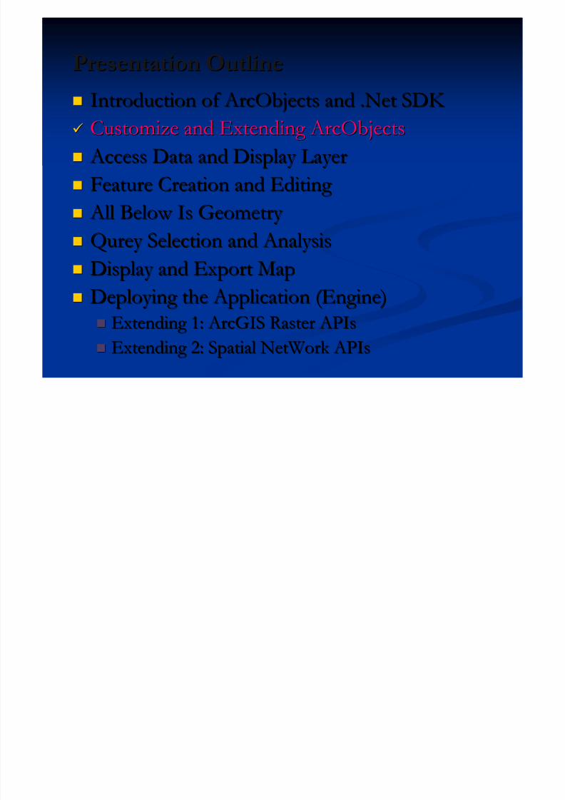
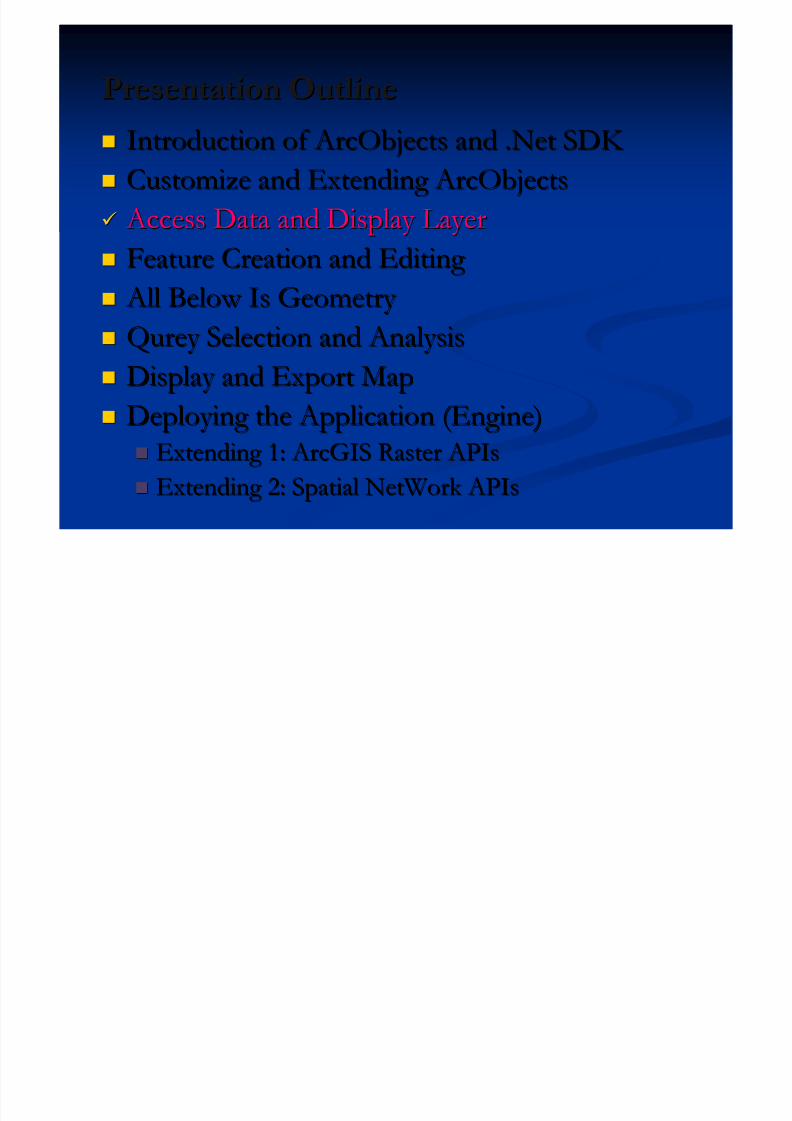
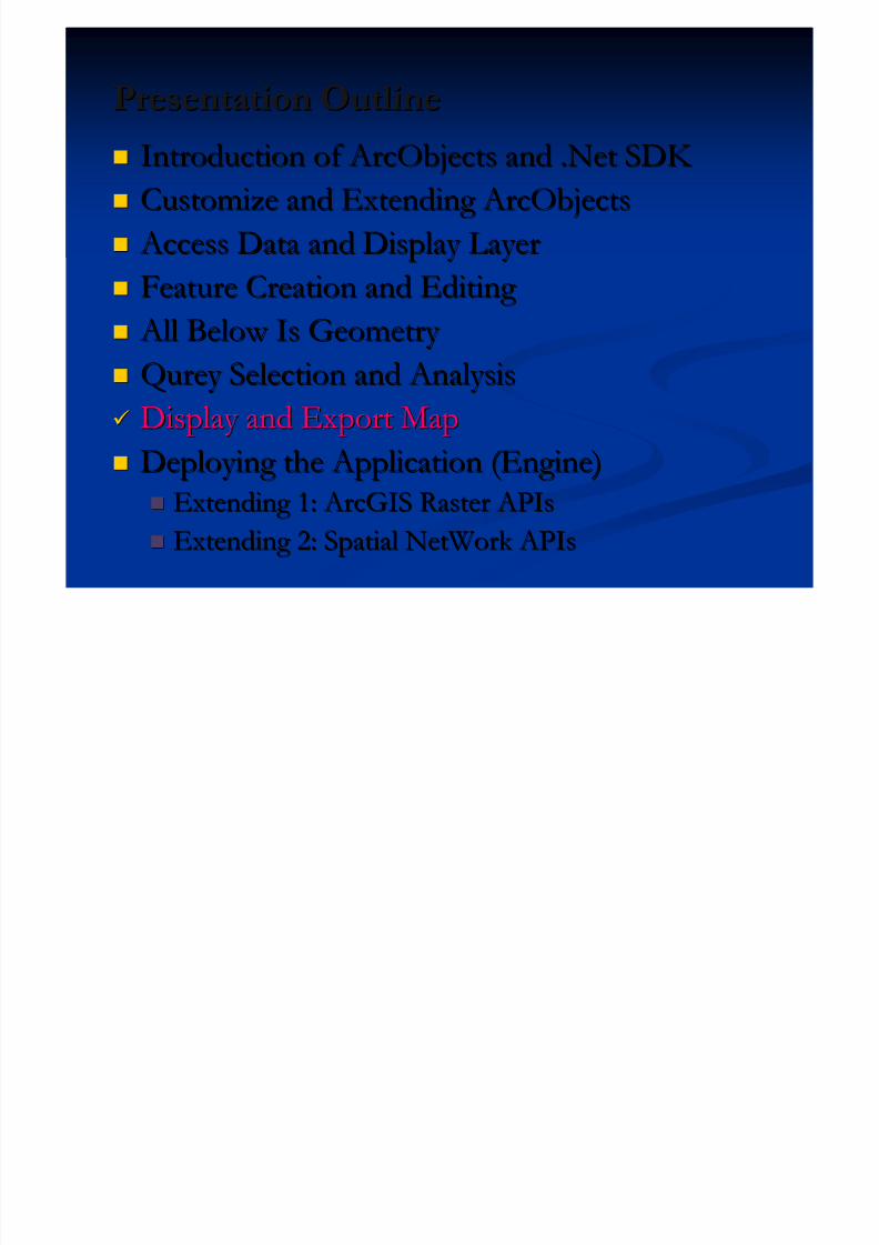
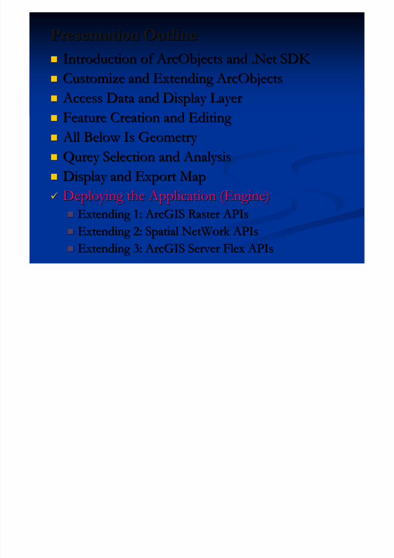
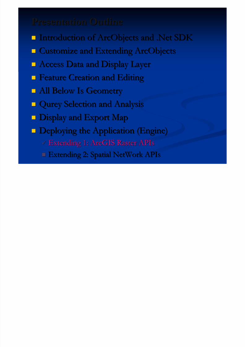
Presentation OutlinePresentation Outline Introduction of ArcObjects and .Net SDK Introduction of ArcObjects and .Net SDK
Customize and Extending ArcObjectsCustomize and Extending ArcObjects Access Data and Display Layer Access Data and Display Layer
Feature Creation and Editing Feature Creation and Editing
All Below Is Geometry All Below Is Geometry Qurey Selection and AnalysisQurey Selection and Analysis
Display and Export MapDisplay and Export Map Deploying the Application (Engine)Deploying the Application (Engine)
Extending 1: ArcGIS Raster APIsExtending 1: ArcGIS Raster APIs
Extending 2: Spatial NetWork APIsExtending 2: Spatial NetWork APIs
5/13/2018 Developing Wtih Arcobjets10 - slidepdf.com
http://slidepdf.com/reader/full/developing-wtih-arcobjets10 3/106
What Is About ArcObjectsWhat Is About ArcObjects
ArcObjects is a library of COM (Component Object ArcObjects is a library of COM (Component Object
Model ) thatModel ) that make up the foundation of ArcGISmake up the foundation of ArcGIS.. ArcObjects is ArcObjects is differentdifferent from ArcGIS Engine.from ArcGIS Engine.
Engine Runtime is a part of ArcObjects library Engine Runtime is a part of ArcObjects library
ArcObjects can consume as Desktop, Engine or ArcObjects can consume as Desktop, Engine or
Server, while Engine Runtime only support Engine.Server, while Engine Runtime only support Engine.
When setup ArcGIS application (e.g. ArcMap), When setup ArcGIS application (e.g. ArcMap), ArcObjects is installed ;while Engine is a standalone ArcObjects is installed ;while Engine is a standalone
application using Runtime and SDK (e.g. .NET)application using Runtime and SDK (e.g. .NET)

5/13/2018 Developing Wtih Arcobjets10 - slidepdf.com
http://slidepdf.com/reader/full/developing-wtih-arcobjets10 4/106
What Can ArcObjects DoWhat Can ArcObjects Do
Extending
ArcObjects
Standalone
Application
5/13/2018 Developing Wtih Arcobjets10 - slidepdf.com
http://slidepdf.com/reader/full/developing-wtih-arcobjets10 5/106
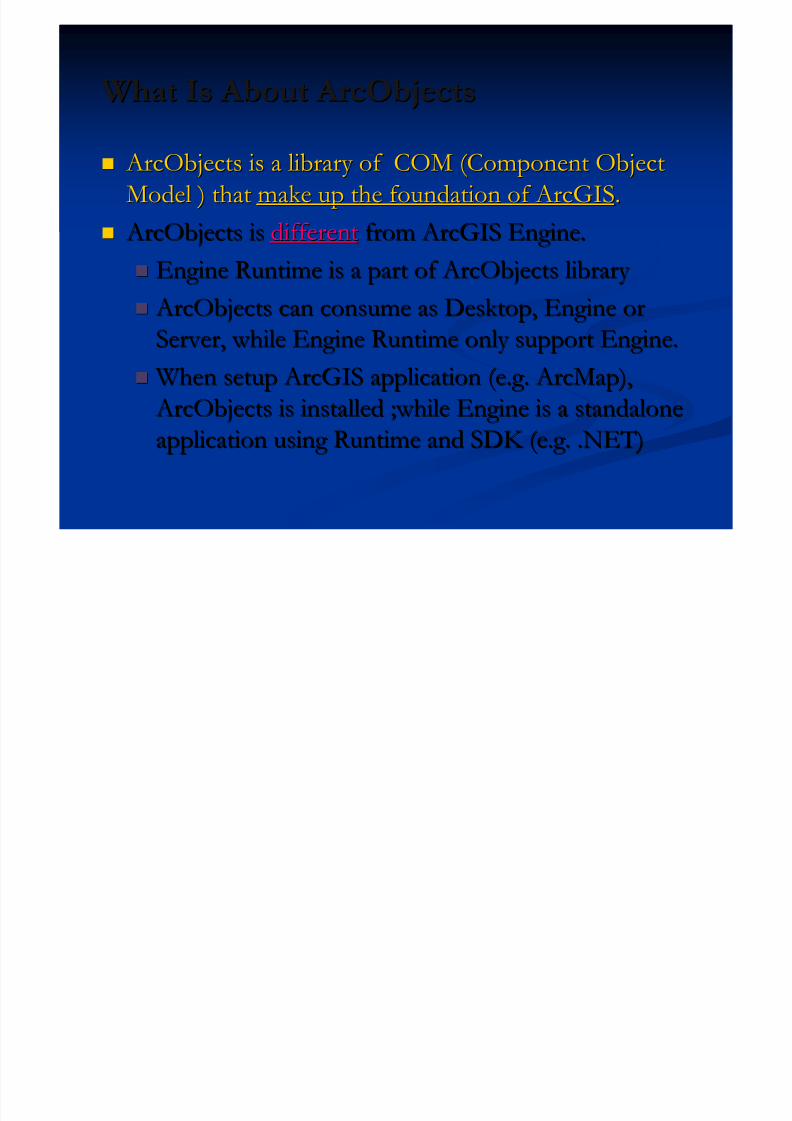
Determine Which Application You NeedDetermine Which Application You Need
To customize the ArcGIS Desktop applications To customize the ArcGIS Desktop applications
( ( ArcObjects Extending ArcObjects Extending ) ) To To build standalone mapping applicationsbuild standalone mapping applications
( ( ArcGIS Engine ArcGIS Engine ) )
To develop Web applications To develop Web applications
(ArcGIS Server)(ArcGIS Server)
Don’t Forget Add-In
5/13/2018 Developing Wtih Arcobjets10 - slidepdf.com
http://slidepdf.com/reader/full/developing-wtih-arcobjets10 6/106
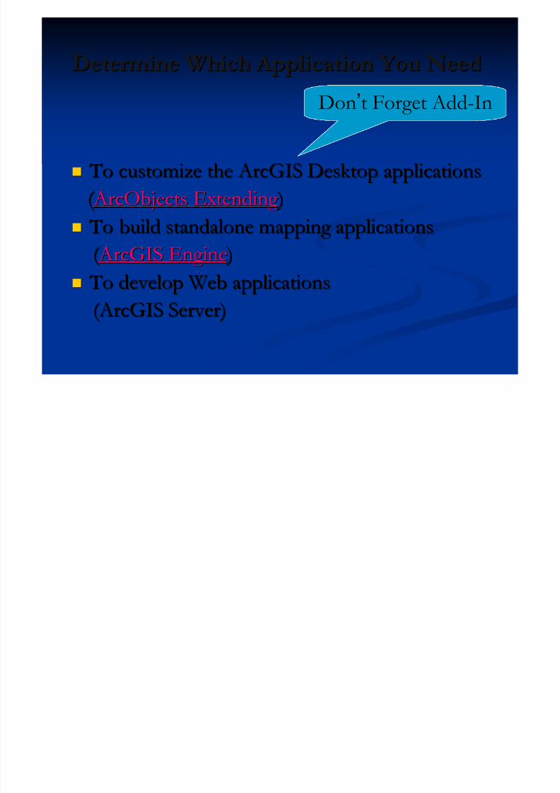
ArcGIS Server
ArcGISDesktop
ArcGISExplorer
WebApplication
ArcGISEngine
ArcGISMobile
DesktopDeveloper Kit
EngineDeveloper Kit
API SDK
Applications
Services
Data(Geodatabase)
.NET .NET
C++ Java
OGC SOAP
.NET Java.NET .NET
API
ArcObjects
KML
ArcGIS Online
Desktop
A complete ArcGIS A complete ArcGIS
FileFile Desktop Workgroup Enterprise
A r c S D E
Personal
REST
JavaScript Flex
Esri中国(北京)培训中心
5/13/2018 Developing Wtih Arcobjets10 - slidepdf.com
http://slidepdf.com/reader/full/developing-wtih-arcobjets10 7/106
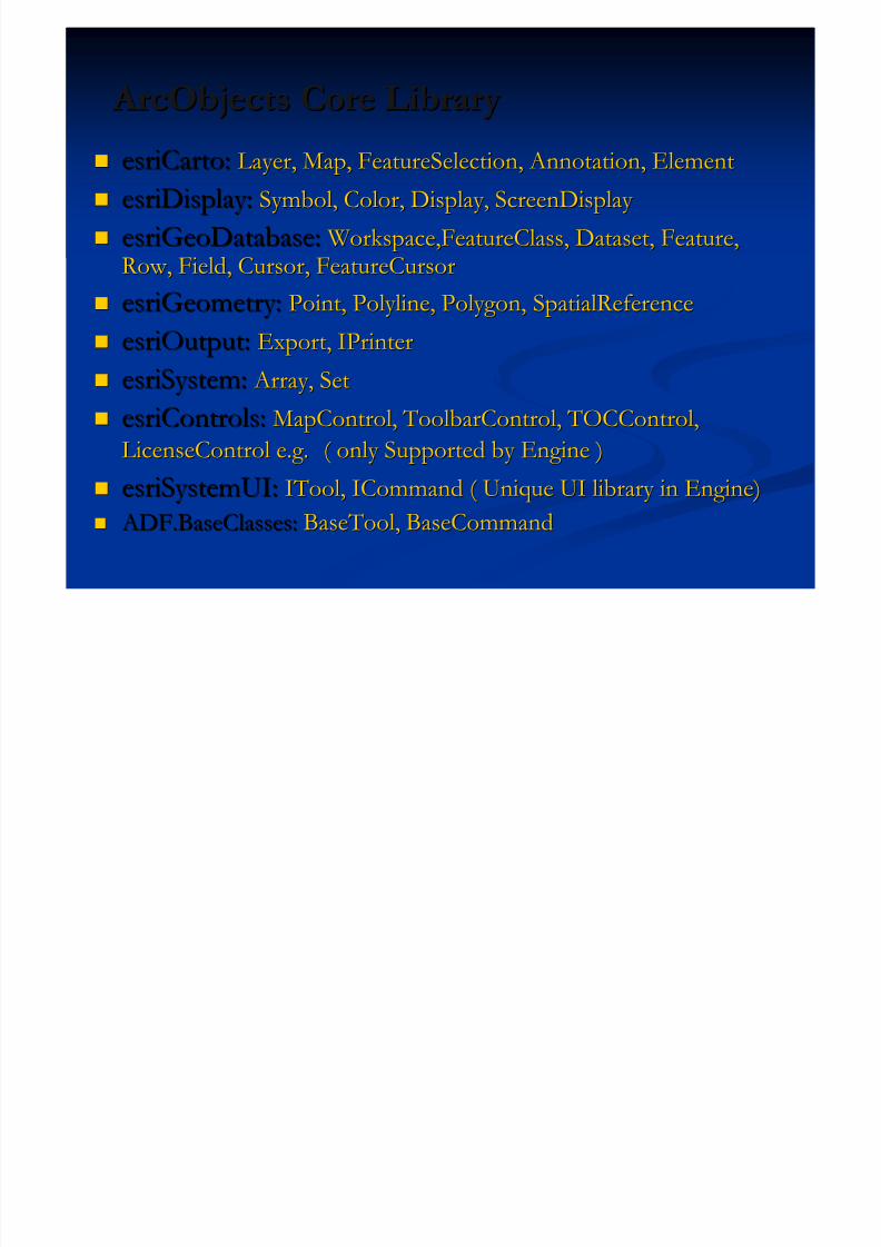
ArcObjects Core Library ArcObjects Core Library esriCarto:esriCarto: Layer, Map, FeatureSelection, Annotation, ElementLayer, Map, FeatureSelection, Annotation, Element
esriDisplay:esriDisplay: Symbol, Color, Display, ScreenDisplay Symbol, Color, Display, ScreenDisplay
esriGeoDatabase:esriGeoDatabase: Workspace,FeatureClass, Dataset, Feature, Workspace,FeatureClass, Dataset, Feature,Row, Field, Cursor, FeatureCursorRow, Field, Cursor, FeatureCursor
esriGeometry:esriGeometry: Point, Polyline, Polygon,Point, Polyline, Polygon, SpatialReferenceSpatialReference
esriOutput:esriOutput: Export, IPrinterExport, IPrinter
esriSystem:esriSystem: Array, Set Array, Set
esriControls:esriControls: MapControl, ToolbarControl, TOCControl,MapControl, ToolbarControl, TOCControl,
LicenseControl e.g.LicenseControl e.g. ( only Supported by Engine )( only Supported by Engine )
esriSystemUI:esriSystemUI: ITool, ICommand ( Unique UI library in Engine)ITool, ICommand ( Unique UI library in Engine)
ADF.BaseClasses: ADF.BaseClasses: BaseTool, BaseCommandBaseTool, BaseCommand

5/13/2018 Developing Wtih Arcobjets10 - slidepdf.com
http://slidepdf.com/reader/full/developing-wtih-arcobjets10 8/106
More LibrariesMore Libraries
esriDataSourceFileesriDataSourceFile
esriDataSourceGDBesriDataSourceGDB
esriDataSourceRasteresriDataSourceRaster
esriGeoProcessing esriGeoProcessing
5/13/2018 Developing Wtih Arcobjets10 - slidepdf.com
http://slidepdf.com/reader/full/developing-wtih-arcobjets10 9/106
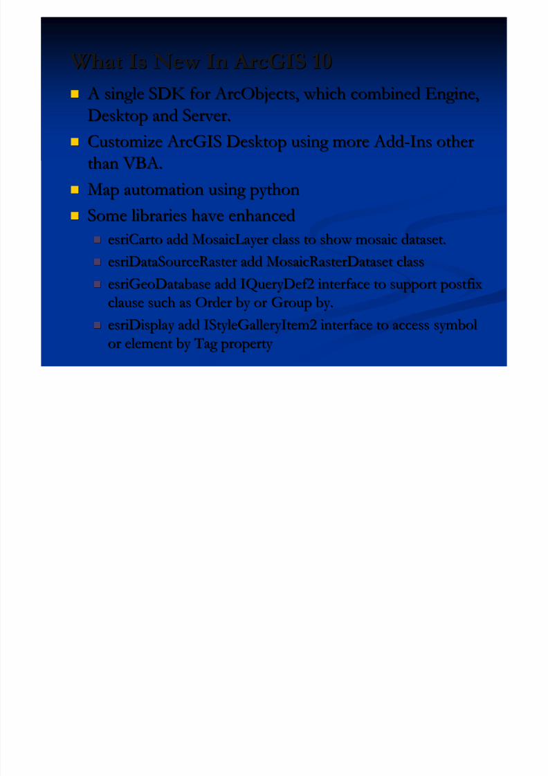
What Is New In ArcGIS 10What Is New In ArcGIS 10 A single SDK for ArcObjects, which combined Engine, A single SDK for ArcObjects, which combined Engine,
Desktop and Server.Desktop and Server.
Customize ArcGIS Desktop using more AddCustomize ArcGIS Desktop using more Add--Ins otherIns otherthan VBA.than VBA.
Map automation using pythonMap automation using python
Some libraries have enhancedSome libraries have enhanced
esriCarto add MosaicLayer class to show mosaic dataset.esriCarto add MosaicLayer class to show mosaic dataset.
esriDataSourceRaster add MosaicRasterDataset classesriDataSourceRaster add MosaicRasterDataset class
esriGeoDatabase add IQueryDef2 interface to support postfixesriGeoDatabase add IQueryDef2 interface to support postfix
clause such as Order by or Group by.clause such as Order by or Group by.
esriDisplay add IStyleGalleryItem2 interface to access symbolesriDisplay add IStyleGalleryItem2 interface to access symbol
or element by Tag property or element by Tag property

5/13/2018 Developing Wtih Arcobjets10 - slidepdf.com
http://slidepdf.com/reader/full/developing-wtih-arcobjets10 10/106
When Need HelpWhen Need Help Developer Help LocalDeveloper Help Local
Documentation and SamplesDocumentation and Samples
Object Model DiagramsObject Model Diagrams
Esri Developer Network, Go to:Esri Developer Network, Go to: edn.esri.comedn.esri.com,,
resource.esri.comresource.esri.com,, surpport.esri.comsurpport.esri.comDocumentation Library Documentation Library
Technical Articles and White Papers Technical Articles and White Papers
Data ModelData Model
Samples and SolutionsSamples and Solutions
ForumsForums www.gisall.com www.gisall.com (Esri)(Esri)
5/13/2018 Developing Wtih Arcobjets10 - slidepdf.com
http://slidepdf.com/reader/full/developing-wtih-arcobjets10 11/106
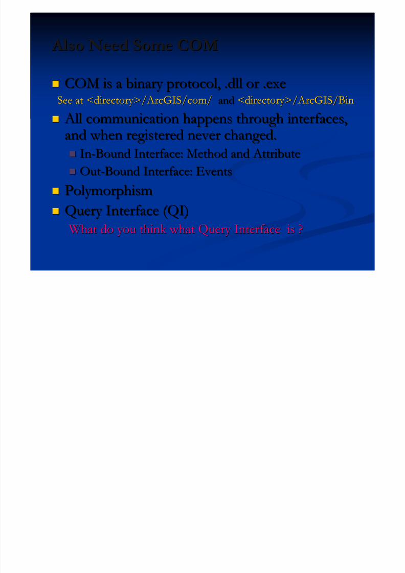
Also Need Some COM Also Need Some COM
COM is a binary protocol, .dll or .exeCOM is a binary protocol, .dll or .exe
See at <directory>/ArcGIS/com/See at <directory>/ArcGIS/com/ andand <directory>/ArcGIS/Bin<directory>/ArcGIS/Bin
All communication happens through interfaces, All communication happens through interfaces,and when registered never changed.and when registered never changed.
InIn--Bound Interface: Method and AttributeBound Interface: Method and Attribute OutOut--Bound Interface: EventsBound Interface: Events
PolymorphismPolymorphism
Query Interface (QI)Query Interface (QI)
What do you think what Query Interface is ? What do you think what Query Interface is ?
5/13/2018 Developing Wtih Arcobjets10 - slidepdf.com
http://slidepdf.com/reader/full/developing-wtih-arcobjets10 12/106
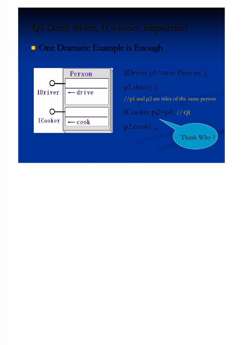
QI Once More, ItQI Once More, It’’s more Importants more Important
One Dramatic Example is EnoughOne Dramatic Example is Enough
IDriver p1=new Person( );
p1.drive( );//p1 and p2 are titles of the same person
ICooker p2=p1; // QI
p2.cook( );
Think Why ?

5/13/2018 Developing Wtih Arcobjets10 - slidepdf.com
http://slidepdf.com/reader/full/developing-wtih-arcobjets10 13/106
Wrapper In .Net SDK Wrapper In .Net SDK
MapControl:MapControl: Map objectMap object
PageLayoutControl:PageLayoutControl: PageLayoutPageLayoutobjectobject
ToolbarControl: ToolbarControl: Container forContainer for
commands, tools, and menuscommands, tools, and menus TOCControl: TOCControl: Displays layerDisplays layer
information for an associatedinformation for an associated
controlcontrol LicenseControl:LicenseControl: Performs licensePerforms license
initializationinitialization
Other ControlsOther Controls……

5/13/2018 Developing Wtih Arcobjets10 - slidepdf.com
http://slidepdf.com/reader/full/developing-wtih-arcobjets10 14/106
Get Ready?Get Ready? ArcGIS Engine Runtime is better. ArcObjects ArcGIS Engine Runtime is better. ArcObjects
SDK is appropriate.SDK is appropriate. Microsoft .Net Framework 3.5 at least and VisualMicrosoft .Net Framework 3.5 at least and Visual
Studio 2008 or above version.Studio 2008 or above version.
5/13/2018 Developing Wtih Arcobjets10 - slidepdf.com
http://slidepdf.com/reader/full/developing-wtih-arcobjets10 15/106
Presentation OutlinePresentation Outline Introduction of ArcObjects and .Net SDK Introduction of ArcObjects and .Net SDK
Customize and Extending ArcObjectsCustomize and Extending ArcObjects
Access Data and Display Layer Access Data and Display Layer
Feature Creation and Editing Feature Creation and Editing
All Below Is Geometry All Below Is Geometry Qurey Selection and AnalysisQurey Selection and Analysis
Display and Export MapDisplay and Export Map
Deploying the Application (Engine)Deploying the Application (Engine)
Extending 1: ArcGIS Raster APIsExtending 1: ArcGIS Raster APIs
Extending 2: Spatial NetWork APIsExtending 2: Spatial NetWork APIs

5/13/2018 Developing Wtih Arcobjets10 - slidepdf.com
http://slidepdf.com/reader/full/developing-wtih-arcobjets10 16/106
ArcGIS Functions Are All Commands ArcGIS Functions Are All Commands Commands are organized into categoriesCommands are organized into categories
COM should be registered in correct categoriesCOM should be registered in correct categories ArcMap Extending: AxCommands ArcMap Extending: AxCommands
ArcGIS Engine: CommandControls ArcGIS Engine: CommandControls
Inherit from BaseClass to override functionality Inherit from BaseClass to override functionality BaseCommandBaseCommand
BaseToolBaseTool
BaseToolbarBaseToolbar BaseMenuBaseMenu
5/13/2018 Developing Wtih Arcobjets10 - slidepdf.com
http://slidepdf.com/reader/full/developing-wtih-arcobjets10 17/106
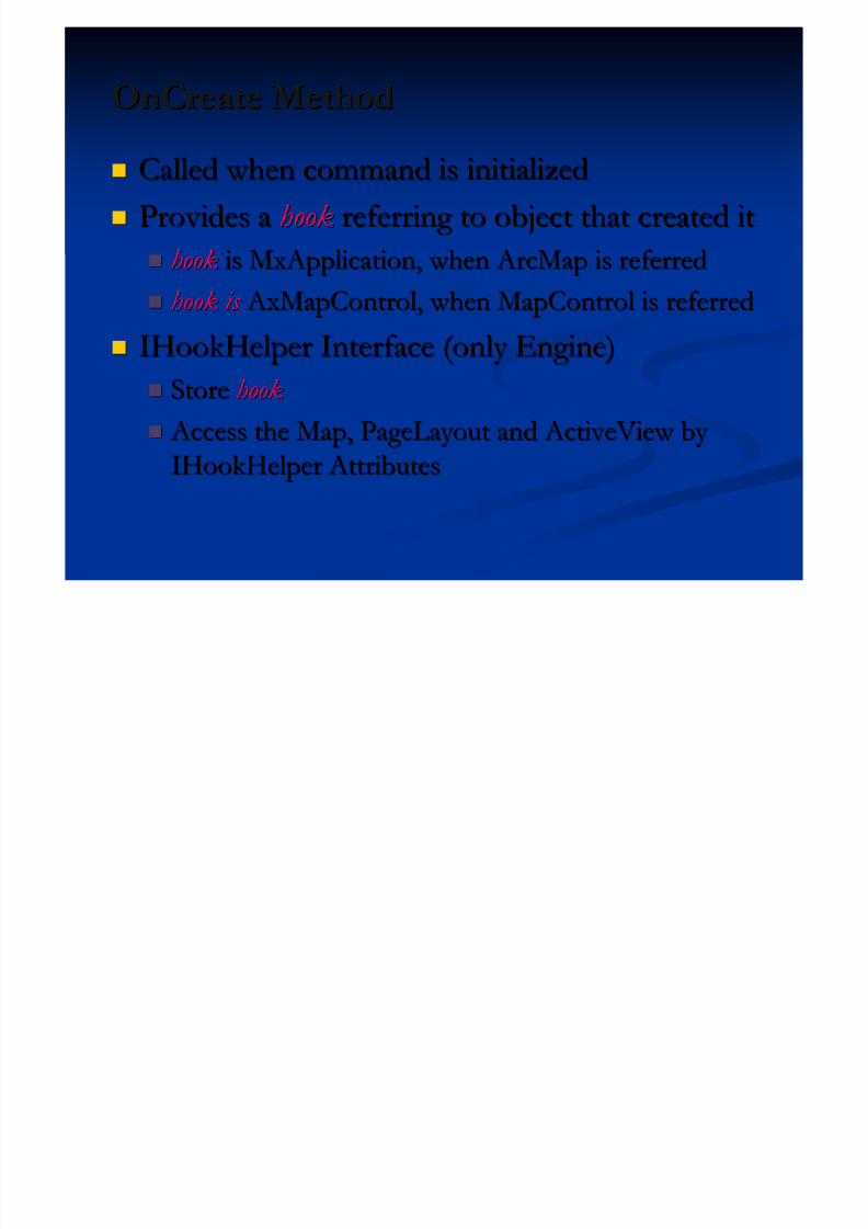
OnCreate MethodOnCreate Method
Called when command is initializedCalled when command is initialized
Provides aProvides a hookhook referring to object that created itreferring to object that created it hookhook is MxApplication, when ArcMap is referredis MxApplication, when ArcMap is referred
hook is hook is AxMapControl, when MapControl is referred AxMapControl, when MapControl is referred
IHookHelper Interface (only Engine)IHookHelper Interface (only Engine)
StoreStore hookhook
Access the Map, PageLayout and ActiveView by Access the Map, PageLayout and ActiveView by IHookHelper AttributesIHookHelper Attributes
5/13/2018 Developing Wtih Arcobjets10 - slidepdf.com
http://slidepdf.com/reader/full/developing-wtih-arcobjets10 18/106
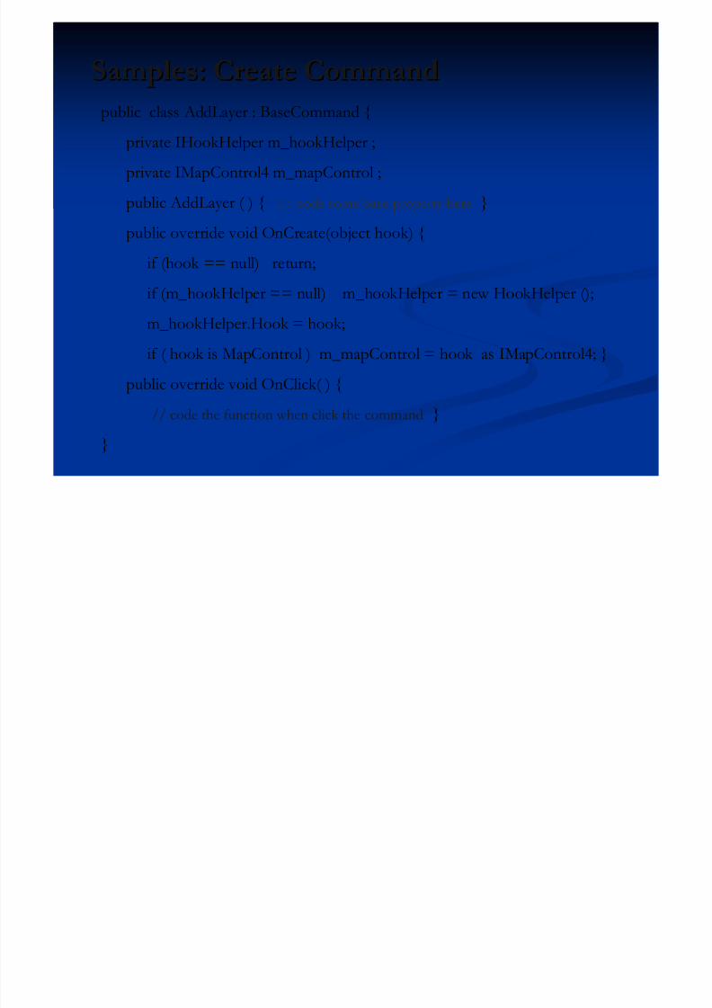
Samples: Create CommandSamples: Create Command
public class AddLayer : BaseCommand {
private IHookHelper m_hookHelper ;
private IMapControl4 m_mapControl ;public AddLayer ( ) { // code some base property here }
public override void OnCreate(object hook) {
if (hook == null) return;if (m_hookHelper == null) m_hookHelper = new HookHelper ();
m_hookHelper.Hook = hook;
if ( hook is MapControl ) m_mapControl = hook as IMapControl4; }
public override void OnClick( ) {
// code the function when click the command }
}
5/13/2018 Developing Wtih Arcobjets10 - slidepdf.com
http://slidepdf.com/reader/full/developing-wtih-arcobjets10 19/106
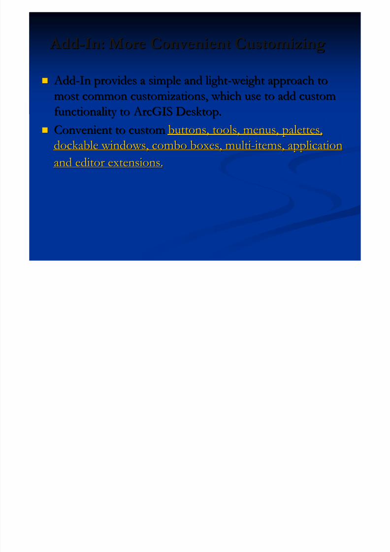
Add Add--In: More Convenient CustomizingIn: More Convenient Customizing
Add Add--In provides a simple and lightIn provides a simple and light-- weight approach to weight approach to
most common customizations, which use to add custommost common customizations, which use to add customfunctionality tofunctionality to ArcGIS Desktop. ArcGIS Desktop.
Convenient to customConvenient to custom buttons, tools, menus, palettes,buttons, tools, menus, palettes,
dockable windows, combo boxes, multidockable windows, combo boxes, multi--items, applicationitems, applicationand editor extensions.and editor extensions.
5/13/2018 Developing Wtih Arcobjets10 - slidepdf.com
http://slidepdf.com/reader/full/developing-wtih-arcobjets10 20/106
Presentation OutlinePresentation Outline Introduction of ArcObjects and .Net SDK Introduction of ArcObjects and .Net SDK
Customize and Extending ArcObjectsCustomize and Extending ArcObjects
Access Data and Display Layer Access Data and Display Layer
Feature Creation and Editing Feature Creation and Editing
All Below Is Geometry All Below Is Geometry Qurey Selection and AnalysisQurey Selection and Analysis
Display and Export MapDisplay and Export Map
Deploying the Application (Engine)Deploying the Application (Engine)
Extending 1: ArcGIS Raster APIsExtending 1: ArcGIS Raster APIs
Extending 2: Spatial NetWork APIsExtending 2: Spatial NetWork APIs
5/13/2018 Developing Wtih Arcobjets10 - slidepdf.com
http://slidepdf.com/reader/full/developing-wtih-arcobjets10 21/106
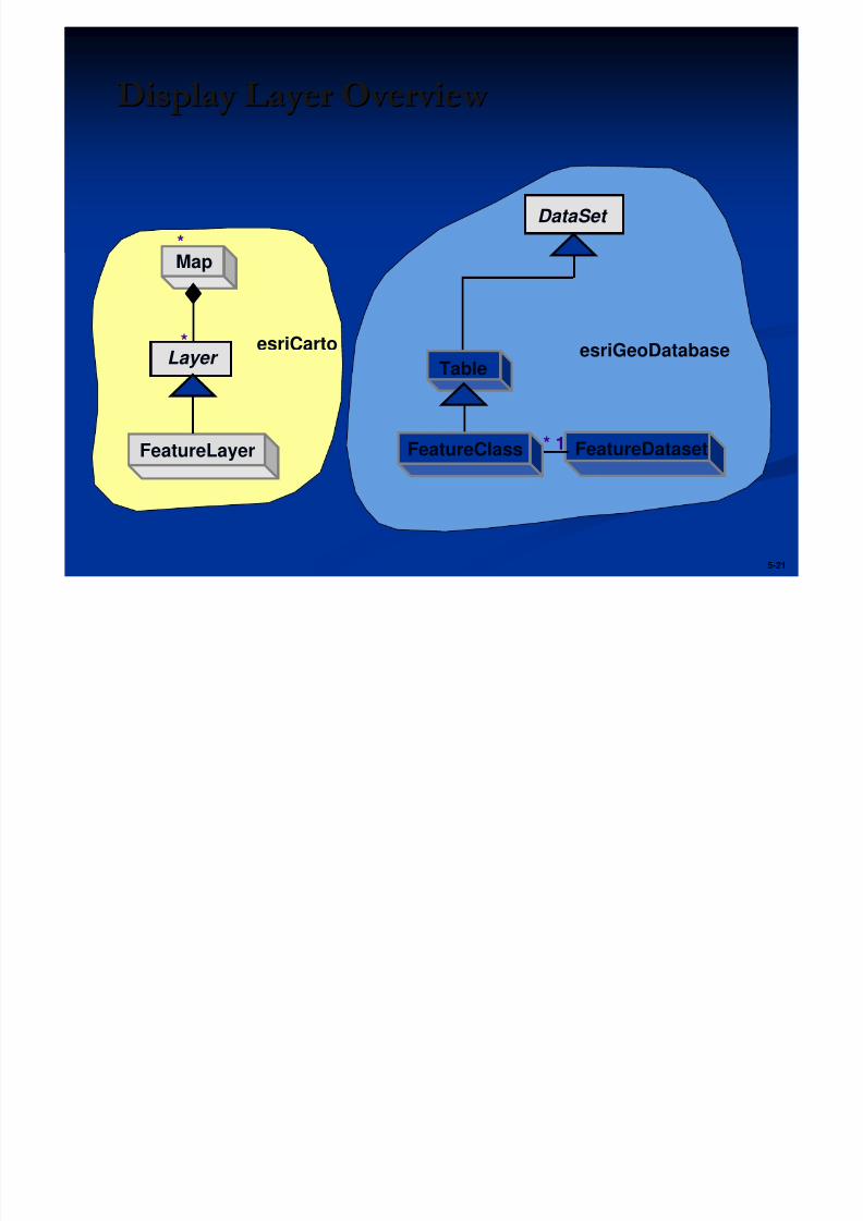
5-21
Display Layer Overview Display Layer Overview
FeatureLayer
Map*
*Layer
FeatureDataset* 1FeatureClass
Table
DataSet
esriCarto esriGeoDatabase
5/13/2018 Developing Wtih Arcobjets10 - slidepdf.com
http://slidepdf.com/reader/full/developing-wtih-arcobjets10 22/106
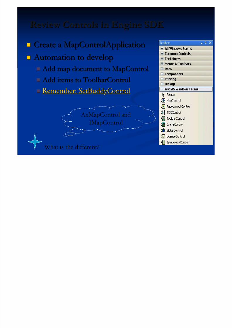
Review Controls in Engine SDK Review Controls in Engine SDK Create a MapControlApplicationCreate a MapControlApplication
Automation to develop Automation to develop Add map document to MapControl Add map document to MapControl
Add items to ToolbarControl Add items to ToolbarControl
Remember: SetBuddyControlRemember: SetBuddyControl
AxMapControl andIMapControl
What is the different?
5/13/2018 Developing Wtih Arcobjets10 - slidepdf.com
http://slidepdf.com/reader/full/developing-wtih-arcobjets10 23/106
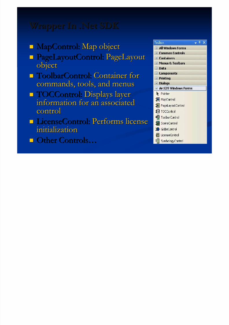
Wrapper In .Net SDK Wrapper In .Net SDK
MapControl:MapControl: Map objectMap object
PageLayoutControl:PageLayoutControl: PageLayoutPageLayoutobjectobject
ToolbarControl: ToolbarControl: Container forContainer for
commands, tools, and menuscommands, tools, and menus TOCControl: TOCControl: Displays layerDisplays layer
information for an associatedinformation for an associated
controlcontrol LicenseControl:LicenseControl: Performs licensePerforms license
initializationinitialization
Other ControlsOther Controls……
5/13/2018 Developing Wtih Arcobjets10 - slidepdf.com
http://slidepdf.com/reader/full/developing-wtih-arcobjets10 24/106
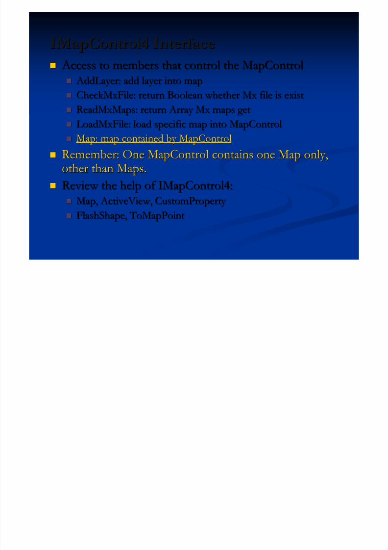
IMapControl4 InterfaceIMapControl4 Interface Access to members that control the MapControl Access to members that control the MapControl
AddLayer: add layer into map AddLayer: add layer into map
CheckMxFile: return Boolean whether Mx file is existCheckMxFile: return Boolean whether Mx file is exist ReadMxMaps: return Array Mx maps getReadMxMaps: return Array Mx maps get
LoadMxFile: load specific map into MapControlLoadMxFile: load specific map into MapControl
Map: map contained by MapControlMap: map contained by MapControl
Remember: One MapControl contains one Map only,Remember: One MapControl contains one Map only,other than Maps.other than Maps.
Review the help of IMapControl4:Review the help of IMapControl4: Map, ActiveView, CustomProperty Map, ActiveView, CustomProperty
FlashShape, ToMapPointFlashShape, ToMapPoint
5/13/2018 Developing Wtih Arcobjets10 - slidepdf.com
http://slidepdf.com/reader/full/developing-wtih-arcobjets10 25/106
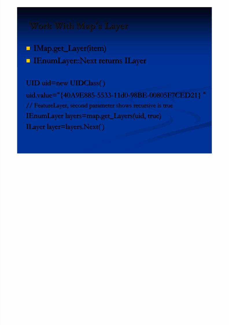
Work With MapWork With Map’’s Layers Layer
IMap.get_Layer(item)IMap.get_Layer(item)
IEnumLayerIEnumLayer::Next returns ILayer::Next returns ILayer
UID uid=new UIDClass( )UID uid=new UIDClass( )uid.value=uid.value=““{40A9E885{40A9E885--55335533--11d011d0--98BE98BE--00805F7CED21}00805F7CED21} ““
// FeatureLayer, second parameter shows recursive is true// FeatureLayer, second parameter shows recursive is true
IEnumLayer layers=map.get_Layers(uid, true)IEnumLayer layers=map.get_Layers(uid, true)ILayer layer=layers.Next( )ILayer layer=layers.Next( )
5/13/2018 Developing Wtih Arcobjets10 - slidepdf.com
http://slidepdf.com/reader/full/developing-wtih-arcobjets10 26/106
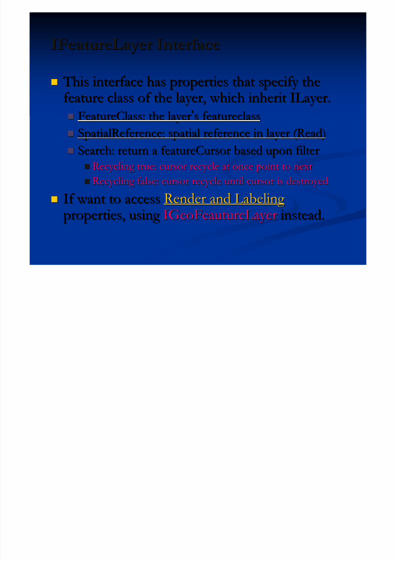
IFeatureLayer InterfaceIFeatureLayer Interface
This interface has properties that specify the This interface has properties that specify the
feature class of the layer, which inherit ILayer.feature class of the layer, which inherit ILayer. FeatureClass: the layerFeatureClass: the layer’’s featureclasss featureclass
SpatialReference: spatial reference in layer (Read)SpatialReference: spatial reference in layer (Read)
Search: return a featureCursor based upon filterSearch: return a featureCursor based upon filter Recycling true: cursor recycle at once point to nextRecycling true: cursor recycle at once point to next
Recycling false: cursor recycle until cursor is destroyedRecycling false: cursor recycle until cursor is destroyed
If want to accessIf want to access Render and Labeling Render and Labeling properties, using properties, using IGeoFeautureLayerIGeoFeautureLayer instead.instead.
5/13/2018 Developing Wtih Arcobjets10 - slidepdf.com
http://slidepdf.com/reader/full/developing-wtih-arcobjets10 27/106
6-27
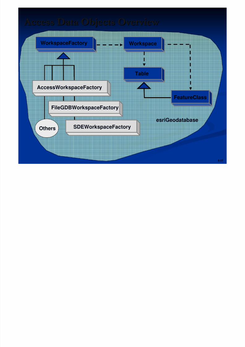
Access Data Objects Overview Access Data Objects Overview
Workspace
Others
FileGDBWorkspaceFactory
AccessWorkspaceFactory
SDEWorkspaceFactory
WorkspaceFactory
Table
FeatureClass
esriGeodatabase
5/13/2018 Developing Wtih Arcobjets10 - slidepdf.com
http://slidepdf.com/reader/full/developing-wtih-arcobjets10 28/106
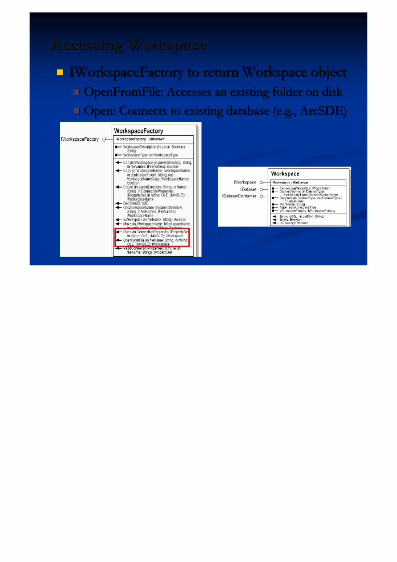
Accessing Workspace Accessing Workspace IWorkspaceFactory to return Workspace objectIWorkspaceFactory to return Workspace object
OpenFromFile: Accesses an existing folder on disk OpenFromFile: Accesses an existing folder on disk
Open: Connects to existing database (e.g., ArcSDE)Open: Connects to existing database (e.g., ArcSDE)
5/13/2018 Developing Wtih Arcobjets10 - slidepdf.com
http://slidepdf.com/reader/full/developing-wtih-arcobjets10 29/106
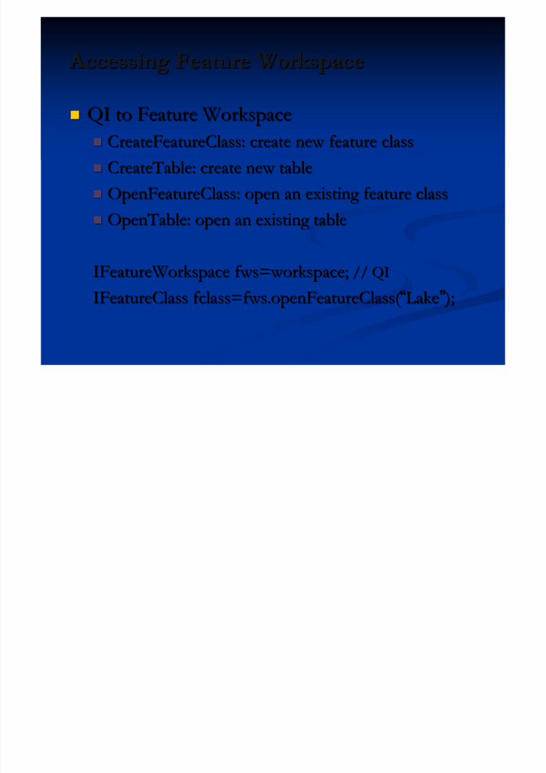
Accessing Feature Workspace Accessing Feature Workspace
QI to Feature WorkspaceQI to Feature Workspace
CreateFeatureClass: create new feature classCreateFeatureClass: create new feature class CreateTable: create new tableCreateTable: create new table
OpenFeatureClass: open an existing feature classOpenFeatureClass: open an existing feature class
OpenTable: open an existing tableOpenTable: open an existing table
IFeatureWorkspace fws=workspace;IFeatureWorkspace fws=workspace; // QI// QI
IFeatureClass fclass=fws.openFeatureClass( IFeatureClass fclass=fws.openFeatureClass( ““LakeLake”” ); );
5/13/2018 Developing Wtih Arcobjets10 - slidepdf.com
http://slidepdf.com/reader/full/developing-wtih-arcobjets10 30/106
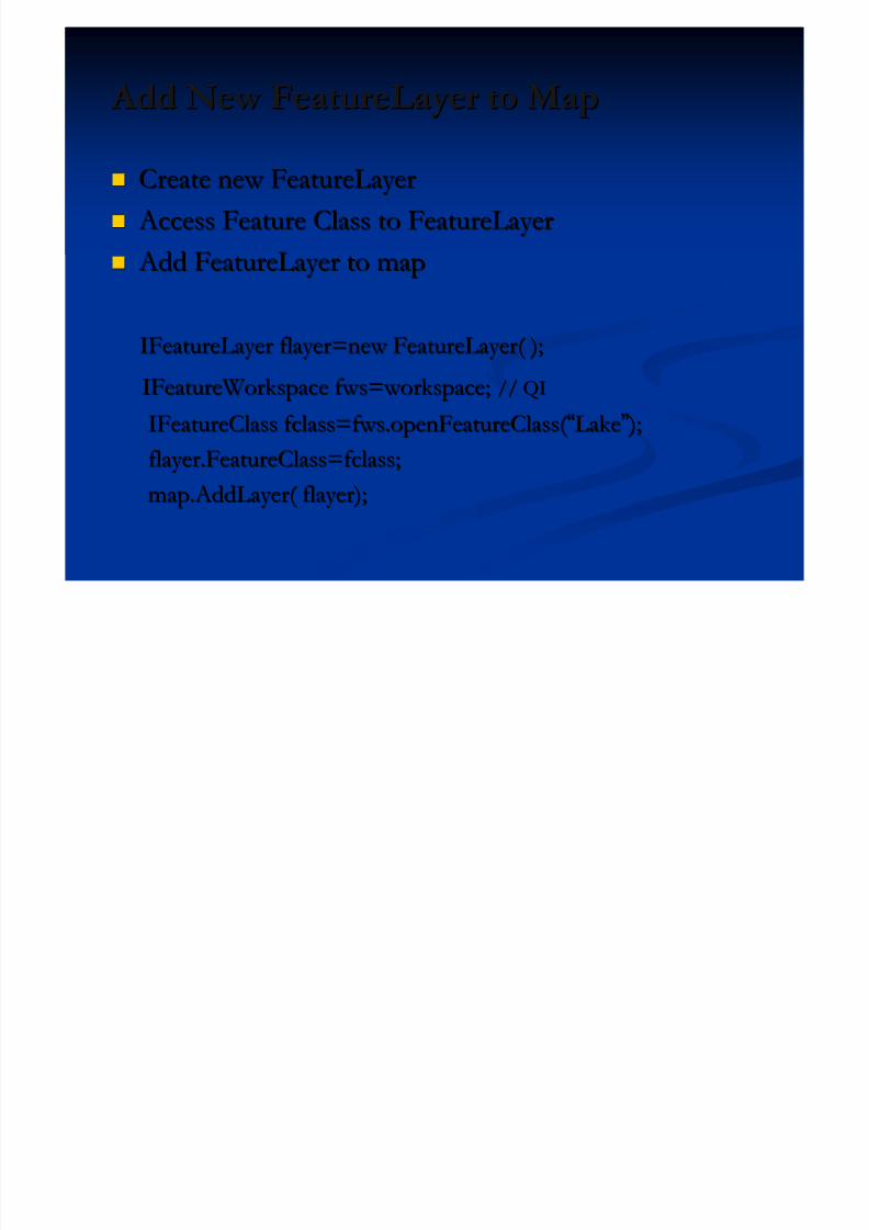
Add New FeatureLayer to Map Add New FeatureLayer to Map
Create new FeatureLayerCreate new FeatureLayer
Access Feature Class to FeatureLayer Access Feature Class to FeatureLayer Add FeatureLayer to map Add FeatureLayer to map
IFeatureLayer flayer=new FeatureLayer( );IFeatureLayer flayer=new FeatureLayer( );
IFeatureWorkspace fws=workspace;IFeatureWorkspace fws=workspace; // QI// QI
IFeatureClass fclass=fws.openFeatureClass( IFeatureClass fclass=fws.openFeatureClass( ““LakeLake”” ); );flayer.FeatureClass=fclass;flayer.FeatureClass=fclass;
map.AddLayer( flayer);map.AddLayer( flayer);

5/13/2018 Developing Wtih Arcobjets10 - slidepdf.com
http://slidepdf.com/reader/full/developing-wtih-arcobjets10 31/106
Exercise 01: ArcGIS Control ApplicationExercise 01: ArcGIS Control Application Create MapControl ApplicationCreate MapControl Application
Using IMapControl InterfaceUsing IMapControl Interface Create Tab Control: Map and PageLayoutCreate Tab Control: Map and PageLayout
Set Buddy ControlSet Buddy Control
Add Tab Control Events Add Tab Control Events
5/13/2018 Developing Wtih Arcobjets10 - slidepdf.com
http://slidepdf.com/reader/full/developing-wtih-arcobjets10 32/106
Presentation OutlinePresentation Outline Introduction of ArcObjects and .Net SDK Introduction of ArcObjects and .Net SDK
Customize and Extending ArcObjectsCustomize and Extending ArcObjects
Access Data and Display Layer Access Data and Display Layer
Feature Creation and Editing Feature Creation and Editing
All Below Is Geometry All Below Is Geometry Qurey Selection and AnalysisQurey Selection and Analysis
Display and Export MapDisplay and Export Map
Deploying the Application (Engine)Deploying the Application (Engine)
Extending 1: ArcGIS Raster APIsExtending 1: ArcGIS Raster APIs
Extending 2: Spatial NetWork APIsExtending 2: Spatial NetWork APIs
5/13/2018 Developing Wtih Arcobjets10 - slidepdf.com
http://slidepdf.com/reader/full/developing-wtih-arcobjets10 33/106
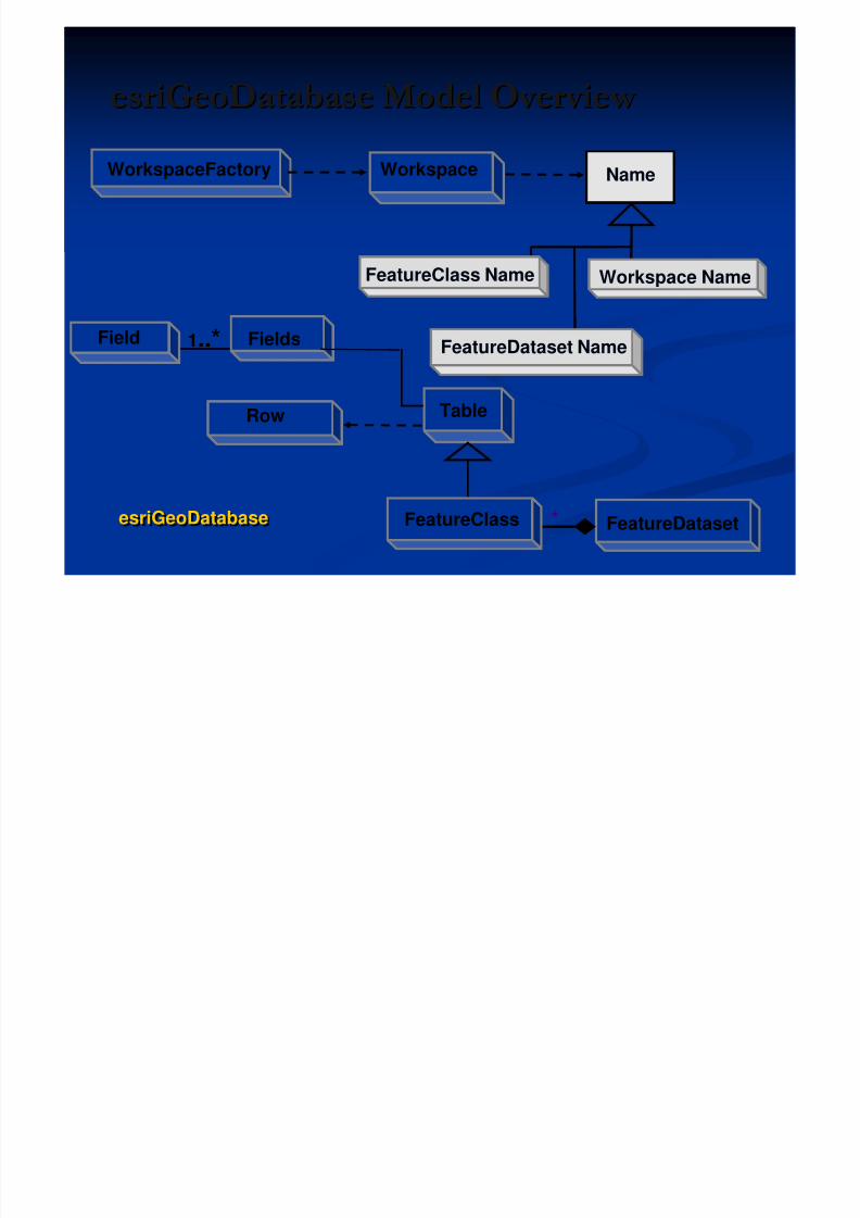
esriGeoDatabase Model Overview esriGeoDatabase Model Overview WorkspaceFactory
Workspace Name
Workspace
Table
FieldsField
Row
FeatureClass
1..*
Name
FeatureClass Name
FeatureDataset Name
FeatureDataset*esriGeoDatabaseesriGeoDatabase
5/13/2018 Developing Wtih Arcobjets10 - slidepdf.com
http://slidepdf.com/reader/full/developing-wtih-arcobjets10 34/106
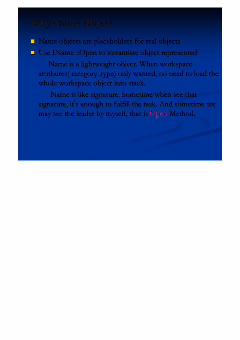
Why Name ObjectWhy Name Object
Name objects are placeholders for real objectsName objects are placeholders for real objects
Use IName ::Open to instantiate object representedUse IName ::Open to instantiate object represented
Name is a lightweight object. When workspaceName is a lightweight object. When workspaceattributes( category ,type) only wanted, no need to load theattributes( category ,type) only wanted, no need to load the
whole workspace object into stack. whole workspace object into stack.
Name is like signature. Sometime when see thatName is like signature. Sometime when see that
signature, itsignature, it’’s enough to fulfill the task. And sometime wes enough to fulfill the task. And sometime we
may see the leader by myself, that ismay see the leader by myself, that is OpenOpen Method.Method.

5/13/2018 Developing Wtih Arcobjets10 - slidepdf.com
http://slidepdf.com/reader/full/developing-wtih-arcobjets10 35/106
Sample: Create New WorkspaceSample: Create New Workspace
IWorkspaceFactory IWorkspaceFactory wsf=new FileGDBWorkspaceFactory(); wsf=new FileGDBWorkspaceFactory();
// create new workspace (GDB), return error if existed// create new workspace (GDB), return error if existed
IWorkspaceName wsn=wsf.Create( path ,name ,null , null)IWorkspaceName wsn=wsf.Create( path ,name ,null , null);;
IName pName=(IName) wsn;IName pName=(IName) wsn;
// get the workspace through open method// get the workspace through open method
IWorkspace ws=pName.open();IWorkspace ws=pName.open();
5/13/2018 Developing Wtih Arcobjets10 - slidepdf.com
http://slidepdf.com/reader/full/developing-wtih-arcobjets10 36/106
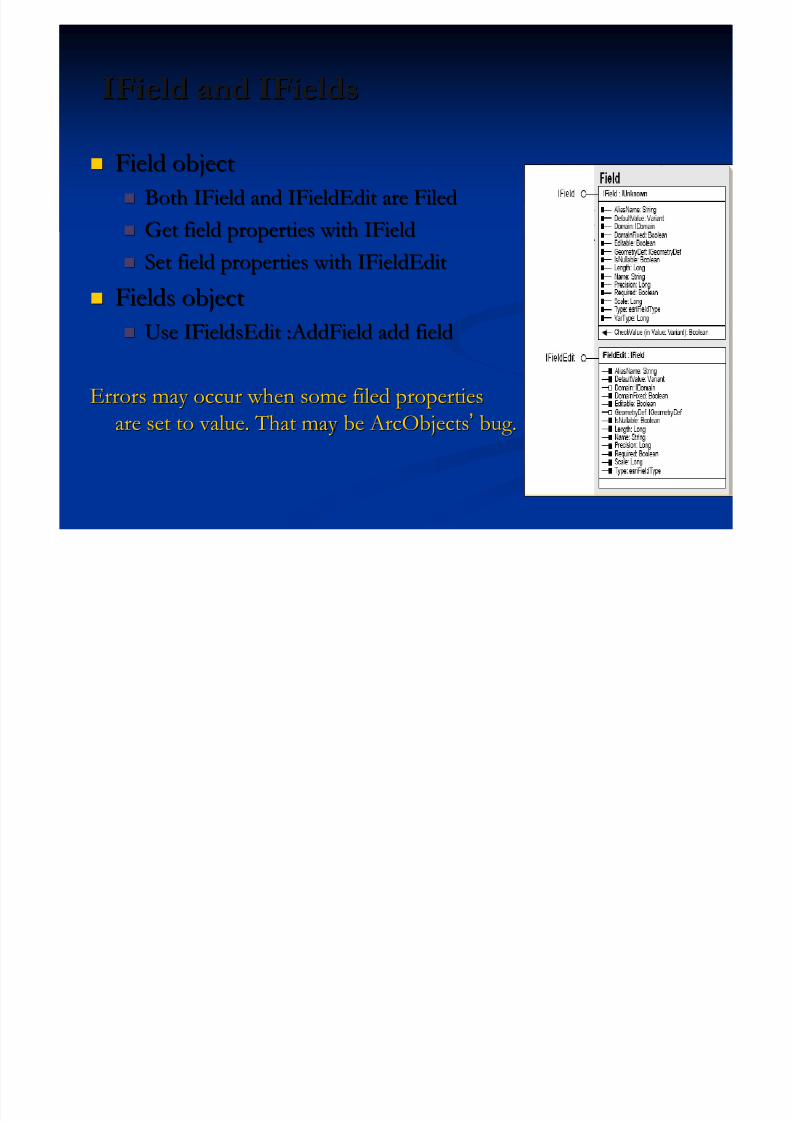
IField and IFieldsIField and IFields
Field objectField object
Both IField and IFieldEdit are FiledBoth IField and IFieldEdit are Filed Get field properties with IFieldGet field properties with IField
Set field properties with IFieldEditSet field properties with IFieldEdit
Fields objectFields object Use IFieldsEdit :AddField add fieldUse IFieldsEdit :AddField add field
Errors may occur when some filed propertiesErrors may occur when some filed propertiesare set to value. That may be ArcObjectsare set to value. That may be ArcObjects’’ bug.bug.
5/13/2018 Developing Wtih Arcobjets10 - slidepdf.com
http://slidepdf.com/reader/full/developing-wtih-arcobjets10 37/106
Create New DataCreate New Data IFeatureWorkspace InterfaceIFeatureWorkspace Interface
CreateTable: Required Common Fields, no Geometry CreateTable: Required Common Fields, no Geometry
// Null shows CLSID and EXTCLSID custom behavior// Null shows CLSID and EXTCLSID custom behavior
// The last parameter shows ArcSDE configuration behavior// The last parameter shows ArcSDE configuration behavior
ITable table=fws.CreateTable( ITable table=fws.CreateTable( ““tableNametableName””,Fields,null,null,,Fields,null,null,”””” ) ) CreateFeatureClass: RequiredCreateFeatureClass: Required GeometryDef GeometryDef FieldsFields
andand esriFeatureTypeesriFeatureType
GeometryDef defined GeometryType and SpatialReferenceGeometryDef defined GeometryType and SpatialReference esriFeatureType defined feature types (e.g. esriFTSimple)esriFeatureType defined feature types (e.g. esriFTSimple)
5/13/2018 Developing Wtih Arcobjets10 - slidepdf.com
http://slidepdf.com/reader/full/developing-wtih-arcobjets10 38/106
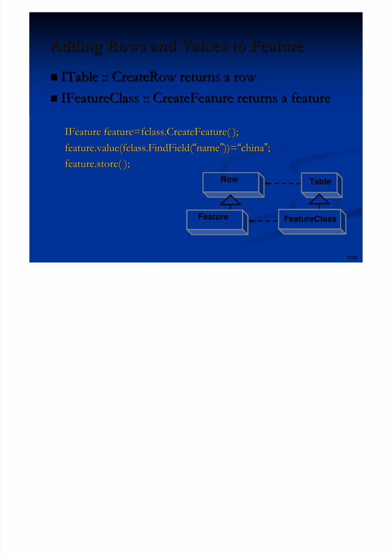
10-38
Adding Rows and Values to Feature Adding Rows and Values to Feature ITable :: CreateRow returns a row ITable :: CreateRow returns a row
IFeatureClass :: CreateFeature returns a featureIFeatureClass :: CreateFeature returns a feature
IFeature feature=fclass.CreateFeature( );IFeature feature=fclass.CreateFeature( );
feature.value(fclass.FindField( feature.value(fclass.FindField( ““namename”” ))= ))=““chinachina””;;feature.store( );feature.store( );
TableRow
FeatureClassFeature
5/13/2018 Developing Wtih Arcobjets10 - slidepdf.com
http://slidepdf.com/reader/full/developing-wtih-arcobjets10 39/106
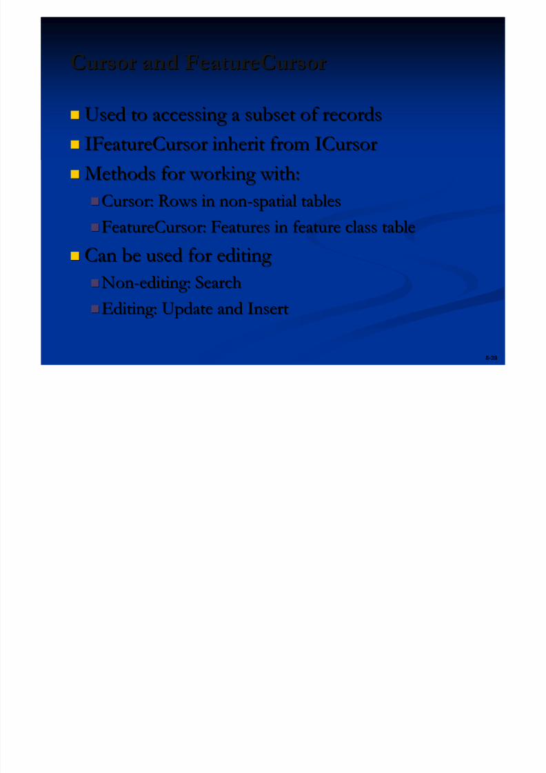
8-39
Cursor and FeatureCursorCursor and FeatureCursor
Used to accessing a subset of recordsUsed to accessing a subset of records
IFeatureCursor inherit from ICursorIFeatureCursor inherit from ICursor Methods for working with:Methods for working with:
Cursor: Rows in nonCursor: Rows in non--spatial tablesspatial tablesFeatureCursor: Features in feature class tableFeatureCursor: Features in feature class table
Can be used for editing Can be used for editing
NonNon--editing: Searchediting: Search
Editing: Update and InsertEditing: Update and Insert

5/13/2018 Developing Wtih Arcobjets10 - slidepdf.com
http://slidepdf.com/reader/full/developing-wtih-arcobjets10 40/106
10-40
Editing with a CursorEditing with a Cursor
Faster than using CreateRow or CreateFeatureFaster than using CreateRow or CreateFeature
Much more efficient for large operationsMuch more efficient for large operations
Use to add, delete, or modify rows or featuresUse to add, delete, or modify rows or features Tables Tables
ICursor :: InsertRow ICursor :: InsertRow
ICursor :: DeleteRow ICursor :: DeleteRow
ICursor :: UpdateRow ICursor :: UpdateRow
Feature classesFeature classes
IFeatureCursor :: InsertFeatureIFeatureCursor :: InsertFeature
IFeatureCursor :: DeleteFeatureIFeatureCursor :: DeleteFeature
IFeatureCursor :: UpdateFeatureIFeatureCursor :: UpdateFeature

5/13/2018 Developing Wtih Arcobjets10 - slidepdf.com
http://slidepdf.com/reader/full/developing-wtih-arcobjets10 41/106
10-41
Editing CursorsEditing Cursors
Update cursorUpdate cursor// filter is a QueryFilter// filter is a QueryFilter
// false the same as IFeatureLayer.Search Method// false the same as IFeatureLayer.Search Method
IFeatureCursor fCursor=fclass.Update(filter,false);IFeatureCursor fCursor=fclass.Update(filter,false);
Insert cursorInsert cursor// false means non// false means non--use Row Buffer, Insert one by oneuse Row Buffer, Insert one by one
// true means use Row Buffer, Insert after cursor completed// true means use Row Buffer, Insert after cursor completed
IFeatureCursor fCursor=fclass.Insert(true);IFeatureCursor fCursor=fclass.Insert(true);

5/13/2018 Developing Wtih Arcobjets10 - slidepdf.com
http://slidepdf.com/reader/full/developing-wtih-arcobjets10 42/106
10-42
Sample: Update and Insert CursorSample: Update and Insert Cursor
IQueryFilter filter=new QueryFilter( );
Filter.WhereClause=“ StateName=‘ Japan’ ”;
IFeatureCursor fCursor=fclass.Update(filter,false);
IFeature feature=fCursor.NextFeature( );
While (feature!=null){
feature.Value(fcalss.FindField( “StateName” ))=“China”;fCursor.UpdateFeature(feature);
feature=fCursor.NextFeature( );}
5/13/2018 Developing Wtih Arcobjets10 - slidepdf.com
http://slidepdf.com/reader/full/developing-wtih-arcobjets10 43/106
Exercise 02: Create New FeatureClassExercise 02: Create New FeatureClass
Access feature workspace Access feature workspace
Create new fieldCreate new field Add GeometryDef to geometry field Add GeometryDef to geometry field
Add new field to fields Add new field to fields Using IFieldChecker Interface to check fieldUsing IFieldChecker Interface to check field
Using CreateFeatureClass methodUsing CreateFeatureClass method
5/13/2018 Developing Wtih Arcobjets10 - slidepdf.com
http://slidepdf.com/reader/full/developing-wtih-arcobjets10 44/106
Presentation OutlinePresentation Outline
Introduction of ArcObjects and .Net SDK Introduction of ArcObjects and .Net SDK
Customize and Extending ArcObjectsCustomize and Extending ArcObjects
Access Data and Display Layer Access Data and Display Layer
Feature Creation and Editing Feature Creation and Editing
All Below Is Geometry All Below Is Geometry Qurey Selection and AnalysisQurey Selection and Analysis
Display and Export MapDisplay and Export Map
Deploying the Application (Engine)Deploying the Application (Engine)
Extending 1: ArcGIS Raster APIsExtending 1: ArcGIS Raster APIs
Extending 2: Spatial NetWork APIsExtending 2: Spatial NetWork APIs
5/13/2018 Developing Wtih Arcobjets10 - slidepdf.com
http://slidepdf.com/reader/full/developing-wtih-arcobjets10 45/106
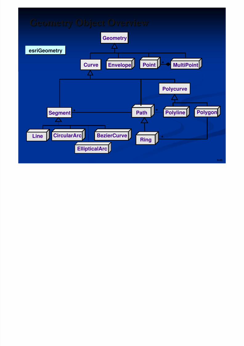
9-45
*
Geometry Object Overview Geometry Object Overview
Point MultiPoint
Ring
PathSegment
Geometry
EnvelopeCurve
Polyline
Line BezierCurveCircularArc
Polycurve
*
*
Polygon
*
esriGeometryesriGeometry
EllipticalArc
P i M l i i d P i C ll i
5/13/2018 Developing Wtih Arcobjets10 - slidepdf.com
http://slidepdf.com/reader/full/developing-wtih-arcobjets10 46/106
9-46
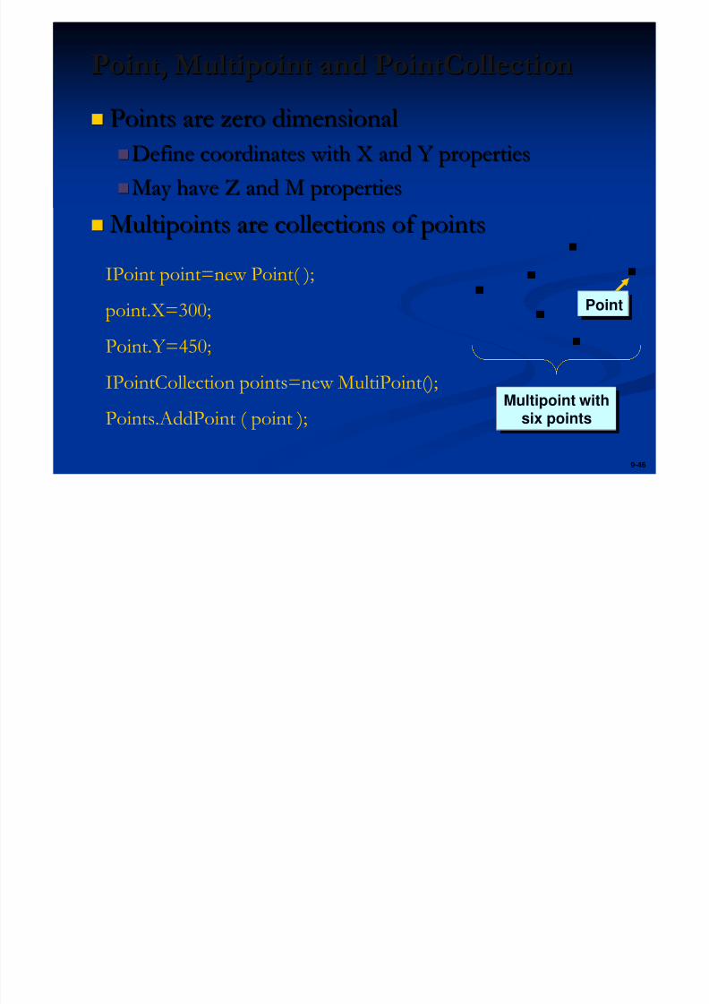
Point, Multipoint and PointCollectionPoint, Multipoint and PointCollection
Points are zero dimensionalPoints are zero dimensional
Define coordinates with X and Y propertiesDefine coordinates with X and Y properties
May have Z and M propertiesMay have Z and M properties
Multipoints are collections of pointsMultipoints are collections of points
PointPoint
Multipoint withsix points
Multipoint withsix points
IPoint point=new Point( );
point.X=300;
Point.Y=450;
IPointCollection points=new MultiPoint();
Points.AddPoint ( point );
SS
5/13/2018 Developing Wtih Arcobjets10 - slidepdf.com
http://slidepdf.com/reader/full/developing-wtih-arcobjets10 47/106
9-47
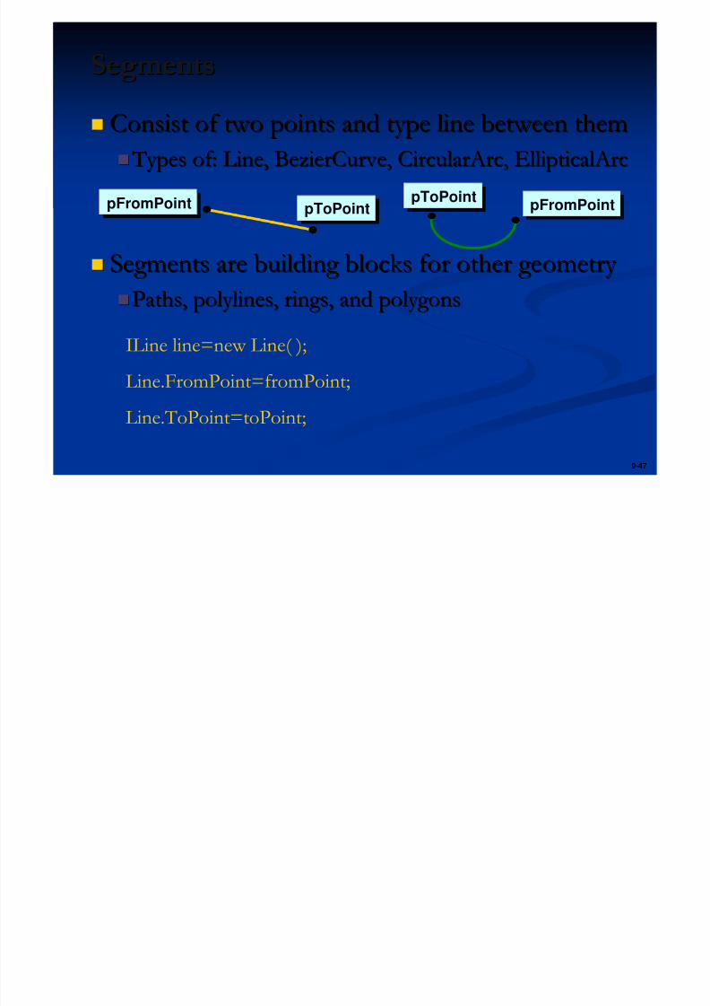
SegmentsSegments
Consist of two points and type line between themConsist of two points and type line between them
Types of: Line, BezierCurve, CircularArc, EllipticalArc Types of: Line, BezierCurve, CircularArc, EllipticalArc
Segments are building blocks for other geometry Segments are building blocks for other geometry Paths, polylines, rings, and polygonsPaths, polylines, rings, and polygons
pFromPointpFromPointpToPointpToPointpToPointpToPointpFromPointpFromPoint
ILine line=new Line( );
Line.FromPoint=fromPoint;
Line.ToPoint=toPoint;
P l li d P lP l li d P l
5/13/2018 Developing Wtih Arcobjets10 - slidepdf.com
http://slidepdf.com/reader/full/developing-wtih-arcobjets10 48/106
9-48
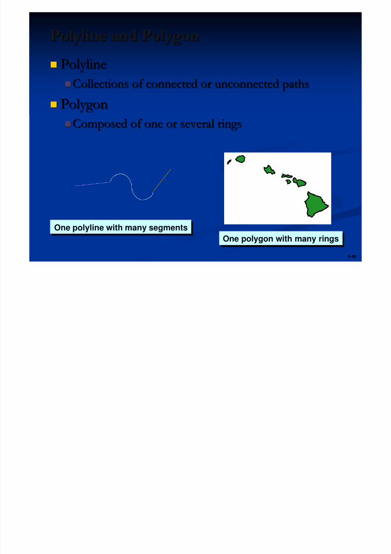
Polyline and PolygonPolyline and Polygon
PolylinePolyline
Collections of connected or unconnected pathsCollections of connected or unconnected paths
PolygonPolygonComposed of one or several ringsComposed of one or several rings
One polygon with many ringsOne polygon with many ringsOne polyline with many segmentsOne polyline with many segments
5/13/2018 Developing Wtih Arcobjets10 - slidepdf.com
http://slidepdf.com/reader/full/developing-wtih-arcobjets10 49/106
9-49
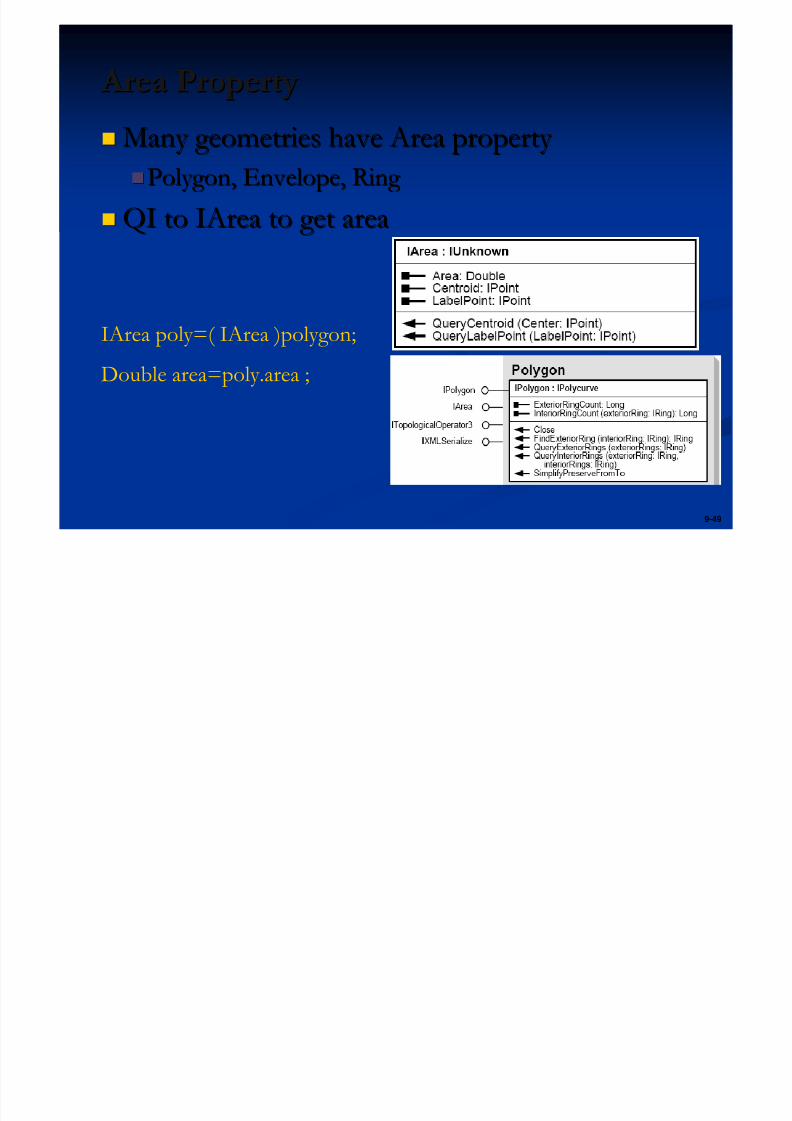
Area Property Area Property
Many geometries have Area property Many geometries have Area property
Polygon, Envelope, Ring Polygon, Envelope, Ring
QI to IArea to get areaQI to IArea to get area
IArea poly=( IArea )polygon;
Double area=poly.area ;
5/13/2018 Developing Wtih Arcobjets10 - slidepdf.com
http://slidepdf.com/reader/full/developing-wtih-arcobjets10 50/106
9-50
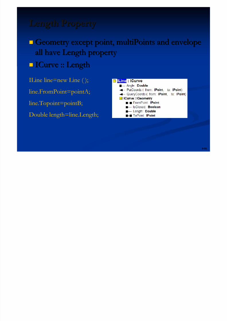
Length PropertyLength Property
Geometry except point, multiPoints and envelopeGeometry except point, multiPoints and envelope
all have Length property all have Length property
ICurve :: LengthICurve :: Length
ILine line=new Line ( );
line.FromPoint=pointA;
line.Topoint=pointB;
Double length=line.Length;
EnvelopeEnvelope
5/13/2018 Developing Wtih Arcobjets10 - slidepdf.com
http://slidepdf.com/reader/full/developing-wtih-arcobjets10 51/106
9-51
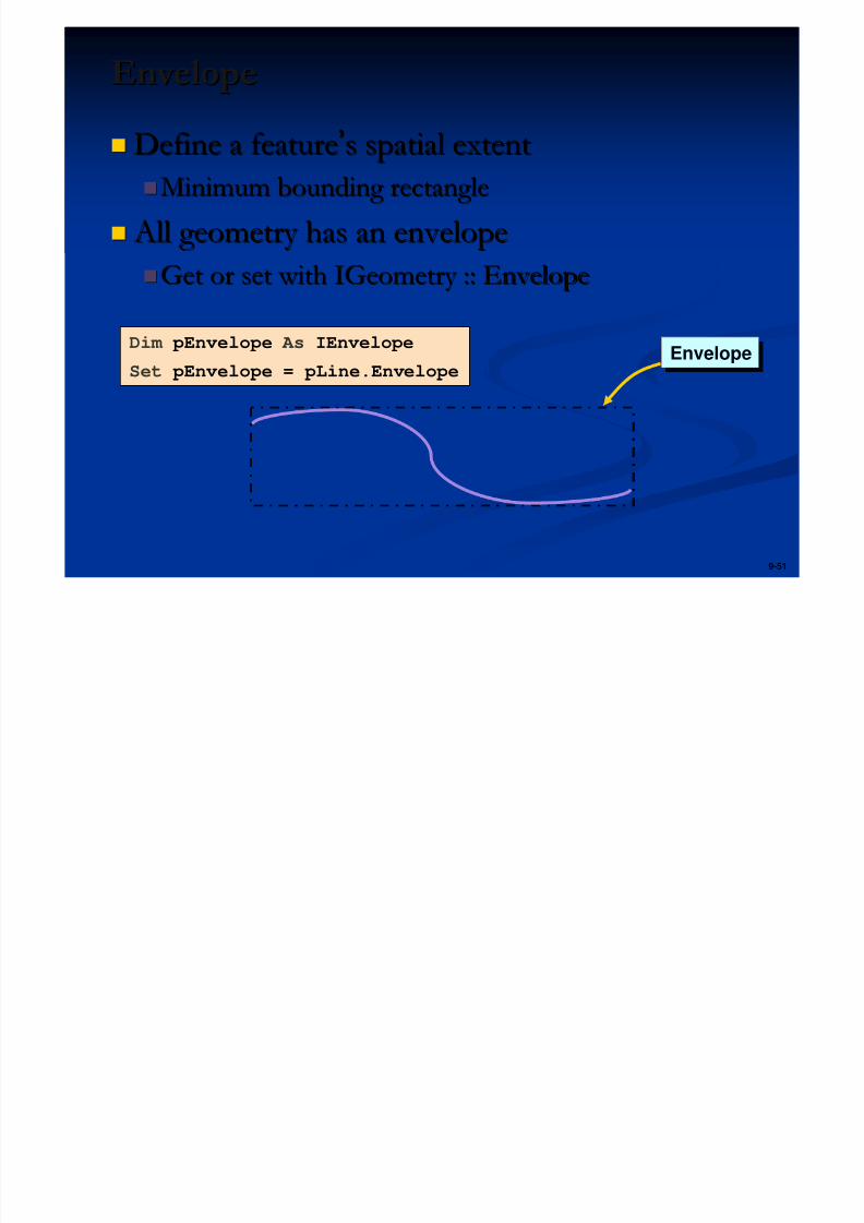
EnvelopeEnvelope
Define a featureDefine a feature’’s spatial extents spatial extent
Minimum bounding rectangleMinimum bounding rectangle
All geometry has an envelope All geometry has an envelopeGet or set with IGeometry :: EnvelopeGet or set with IGeometry :: Envelope
Dim pEnvelope As IEnvelope
Set pEnvelope = pLine.EnvelopeEnvelopeEnvelope
Spatial ReferenceSpatial Reference
5/13/2018 Developing Wtih Arcobjets10 - slidepdf.com
http://slidepdf.com/reader/full/developing-wtih-arcobjets10 52/106
9-52
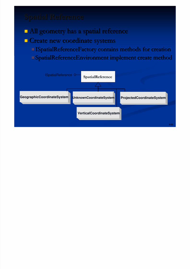
Spatial ReferenceSpatial Reference
All geometry has a spatial reference All geometry has a spatial reference
Create new coordinate systemsCreate new coordinate systems
ISpatialReferenceFactory contains methods for creationISpatialReferenceFactory contains methods for creationSpatialReferenceEnvironment implement create methodSpatialReferenceEnvironment implement create method
ISpatialReference
GeographicCoordinateSystem ProjectedCoordinateSystemUnknownCoordinateSystem
VerticalCoordinateSystem
SpatialReference
S ti l A l iSp ti l An l i
5/13/2018 Developing Wtih Arcobjets10 - slidepdf.com
http://slidepdf.com/reader/full/developing-wtih-arcobjets10 53/106
9-53
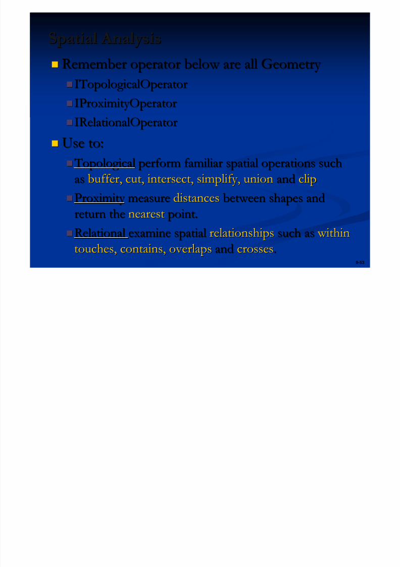
Spatial AnalysisSpatial Analysis
Remember operator below are all Geometry Remember operator below are all Geometry
ITopologicalOperatorITopologicalOperator
IProximityOperatorIProximityOperator IRelationalOperatorIRelationalOperator
Use to:Use to:
Topological Topological perform familiar spatial operations suchperform familiar spatial operations such
asas buffer, cut, intersect, simplify, unionbuffer, cut, intersect, simplify, union andand clipclip
Proximity Proximity measuremeasure distancesdistances between shapes andbetween shapes andreturn thereturn the nearestnearest point.point.
RelationalRelational examine spatialexamine spatial relationshipsrelationships such assuch as within within
touches, contains, overlapstouches, contains, overlaps andand crossescrosses..
IT l i lOIT l i lO t
5/13/2018 Developing Wtih Arcobjets10 - slidepdf.com
http://slidepdf.com/reader/full/developing-wtih-arcobjets10 54/106
9-54
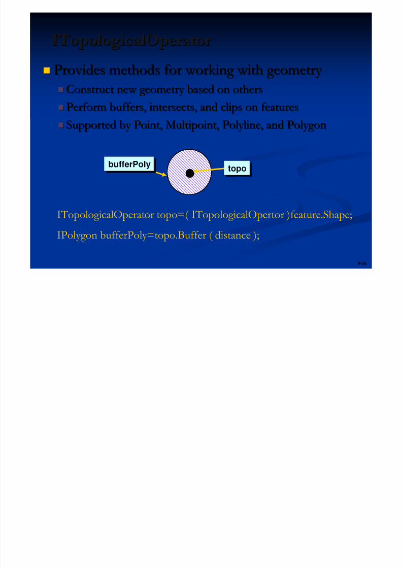
ITopologicalOperatorITopologicalOperator
Provides methods for working with geometry Provides methods for working with geometry
Construct new geometry based on othersConstruct new geometry based on others
Perform buffers, intersects, and clips on featuresPerform buffers, intersects, and clips on features Supported by Point, Multipoint, Polyline, and PolygonSupported by Point, Multipoint, Polyline, and Polygon
topotopobufferPolybufferPoly
ITopologicalOperator topo=( ITopologicalOpertor )feature.Shape;
IPolygon bufferPoly=topo.Buffer ( distance );
IR l ti lO tIR l ti n lOp t
5/13/2018 Developing Wtih Arcobjets10 - slidepdf.com
http://slidepdf.com/reader/full/developing-wtih-arcobjets10 55/106
9-55
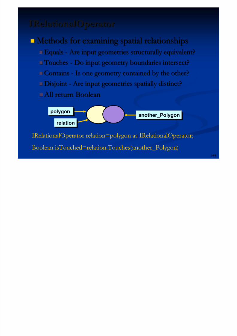
IRelationalOperatorIRelationalOperator
Methods for examining spatial relationshipsMethods for examining spatial relationships
EqualsEquals -- Are input geometries structurally equivalent? Are input geometries structurally equivalent?
Touches Touches -- Do input geometry boundaries intersect?Do input geometry boundaries intersect?ContainsContains -- Is one geometry contained by the other?Is one geometry contained by the other?
DisjointDisjoint -- Are input geometries spatially distinct? Are input geometries spatially distinct?
All return Boolean All return Boolean
polygonpolygon
relationrelation
another_Polygonanother_Polygon
IRelationalOperator relation=polygon as IRelationalOperator;
Boolean isTouched=relation.Touches(another_Polygon)
IP i it Op tIProximityOperator
5/13/2018 Developing Wtih Arcobjets10 - slidepdf.com
http://slidepdf.com/reader/full/developing-wtih-arcobjets10 56/106
9-56
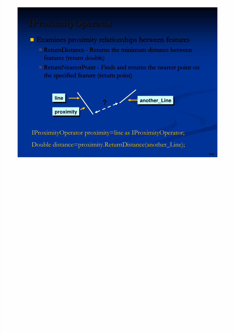
IProximityOperatorIProximityOperator
Examines proximity relationships between featuresExamines proximity relationships between features
ReturnDistanceReturnDistance -- Returns the minimum distance betweenReturns the minimum distance between
features (return double)features (return double)
ReturnNearestPointReturnNearestPoint -- Finds and returns the nearest point onFinds and returns the nearest point on
the specified feature (return point)the specified feature (return point)
?lineline
proximityproximity
another_Lineanother_Line
IProximityOperator proximity=line as IProximityOperator;
Double distance=proximity.ReturnDistance(another_Line);
Di l T f tiDi pl Tr n f rm ti n
5/13/2018 Developing Wtih Arcobjets10 - slidepdf.com
http://slidepdf.com/reader/full/developing-wtih-arcobjets10 57/106
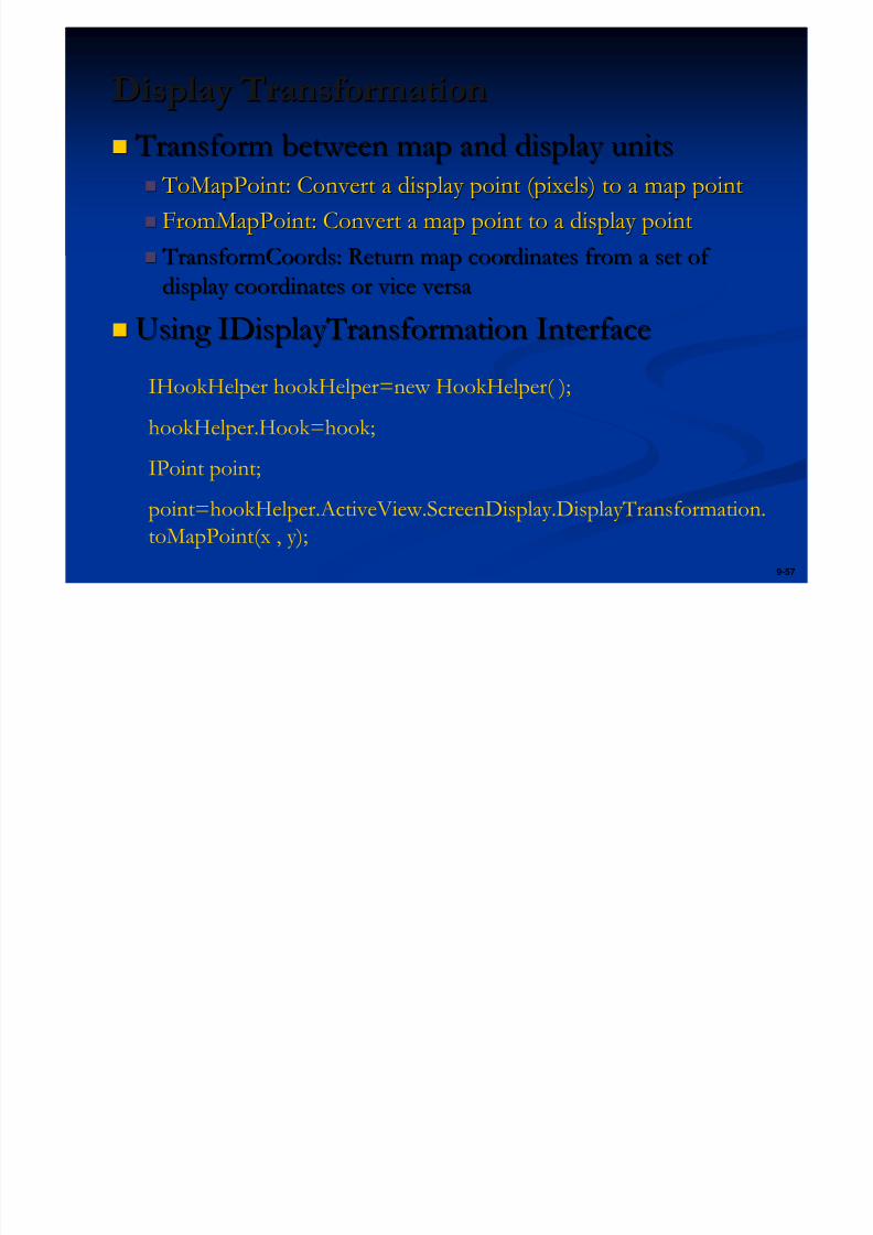
9-57
Display TransformationDisplay Transformation
Transform between map and display units Transform between map and display units ToMapPoint: Convert a display point (pixels) to a map point ToMapPoint: Convert a display point (pixels) to a map point
FromMapPoint: Convert a map point to a display pointFromMapPoint: Convert a map point to a display point TransformCoords: Return map coordinates from a set of TransformCoords: Return map coordinates from a set of
display coordinates or vice versadisplay coordinates or vice versa
Using IDisplayTransformation InterfaceUsing IDisplayTransformation InterfaceIHookHelper hookHelper=new HookHelper( );
hookHelper.Hook=hook;
IPoint point;
point=hookHelper.ActiveView.ScreenDisplay.DisplayTransformation.
toMapPoint(x , y);
i 03 l li lE i 03 P l li P l

5/13/2018 Developing Wtih Arcobjets10 - slidepdf.com
http://slidepdf.com/reader/full/developing-wtih-arcobjets10 58/106
Exercise 03 : Polyline to PolygonExercise 03 : Polyline to Polygon
Create polyline dataCreate polyline data
Using IPointCollection interfaceUsing IPointCollection interface Convert polyline to polygonConvert polyline to polygon
Add polygon to map Add polygon to map
P i O liP i O li
5/13/2018 Developing Wtih Arcobjets10 - slidepdf.com
http://slidepdf.com/reader/full/developing-wtih-arcobjets10 59/106
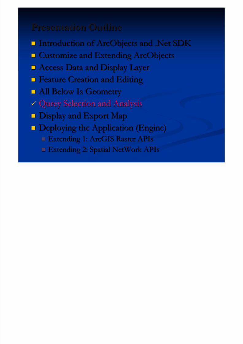
Presentation OutlinePresentation Outline
Introduction of ArcObjects and .Net SDK Introduction of ArcObjects and .Net SDK
Customize and Extending ArcObjectsCustomize and Extending ArcObjects
Access Data and Display Layer Access Data and Display Layer
Feature Creation and Editing Feature Creation and Editing
All Below Is Geometry All Below Is Geometry Qurey Selection and AnalysisQurey Selection and Analysis
Display and Export MapDisplay and Export Map
Deploying the Application (Engine)Deploying the Application (Engine) Extending 1: ArcGIS Raster APIsExtending 1: ArcGIS Raster APIs
Extending 2: Spatial NetWork APIsExtending 2: Spatial NetWork APIs
Object Model O er ieObject Model Overview
5/13/2018 Developing Wtih Arcobjets10 - slidepdf.com
http://slidepdf.com/reader/full/developing-wtih-arcobjets10 60/106
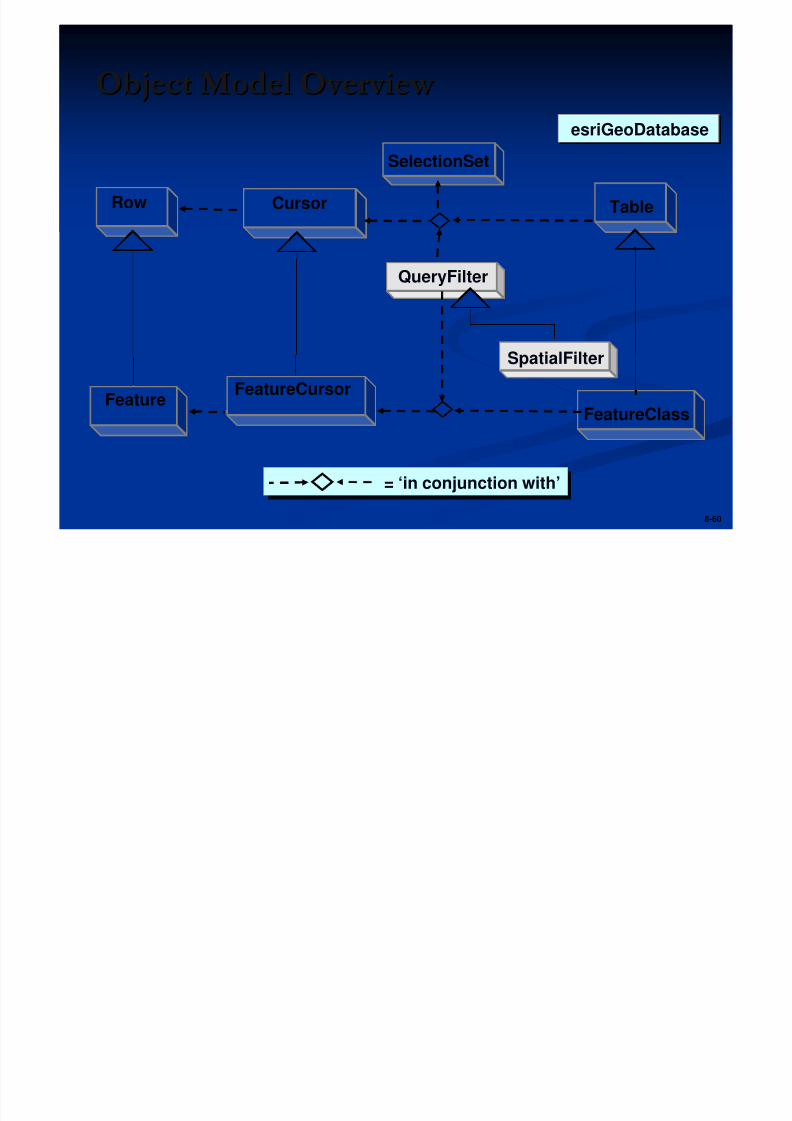
8-60
Object Model Overview Object Model Overview
= ‘in conjunction with’= ‘in conjunction with’
Table
FeatureClass
Cursor
FeatureCursor
Row
Feature
QueryFilter
SelectionSet
SpatialFilter
esriGeoDatabaseesriGeoDatabase
C d F C A iC d F t C A i
5/13/2018 Developing Wtih Arcobjets10 - slidepdf.com
http://slidepdf.com/reader/full/developing-wtih-arcobjets10 61/106
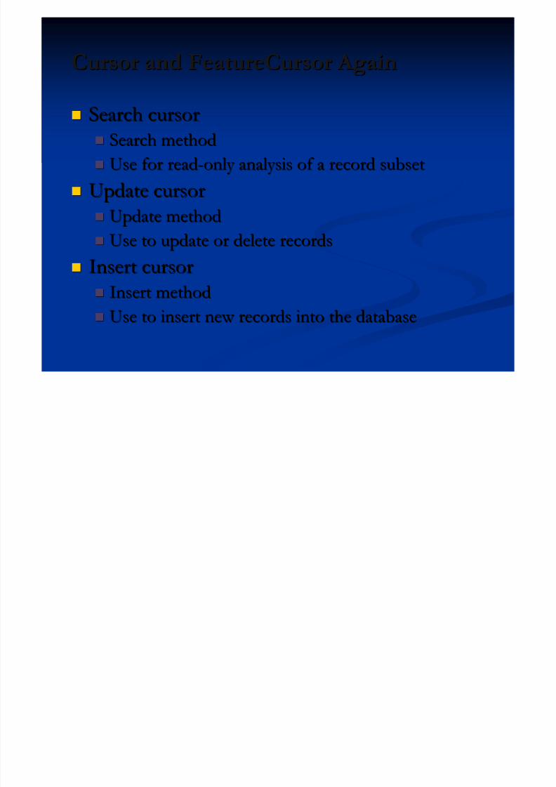
Cursor and FeatureCursor AgainCursor and FeatureCursor Again
Search cursorSearch cursor
Search methodSearch method Use for readUse for read--only analysis of a record subsetonly analysis of a record subset
Update cursorUpdate cursor
Update methodUpdate method Use to update or delete recordsUse to update or delete records
Insert cursorInsert cursor
Insert methodInsert method
Use to insert new records into the databaseUse to insert new records into the database
U i S l tiU in S l ti n
5/13/2018 Developing Wtih Arcobjets10 - slidepdf.com
http://slidepdf.com/reader/full/developing-wtih-arcobjets10 62/106
Using SelectionUsing Selection
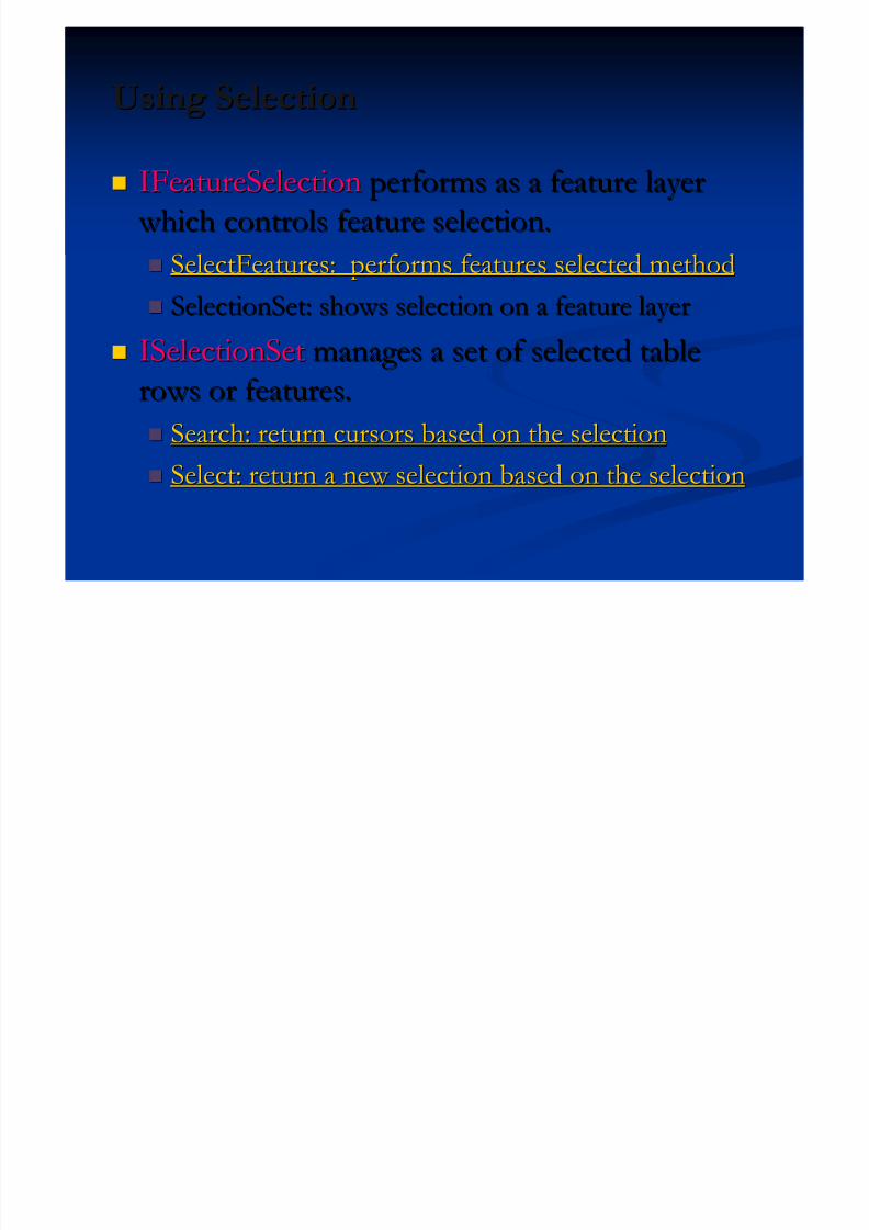
IFeatureSelectionIFeatureSelection performs as a feature layerperforms as a feature layer
which controls feature selection. which controls feature selection. SelectFeatures: performs features selected methodSelectFeatures: performs features selected method
SelectionSet: shows selection on a feature layerSelectionSet: shows selection on a feature layer
ISelectionSetISelectionSet manages a set of selected tablemanages a set of selected table
rows or features.rows or features.
Search: return cursors based on the selectionSearch: return cursors based on the selection Select: return a new selection based on the selectionSelect: return a new selection based on the selection
Creating a FilterCreating a Filter
5/13/2018 Developing Wtih Arcobjets10 - slidepdf.com
http://slidepdf.com/reader/full/developing-wtih-arcobjets10 63/106
8-63
gg
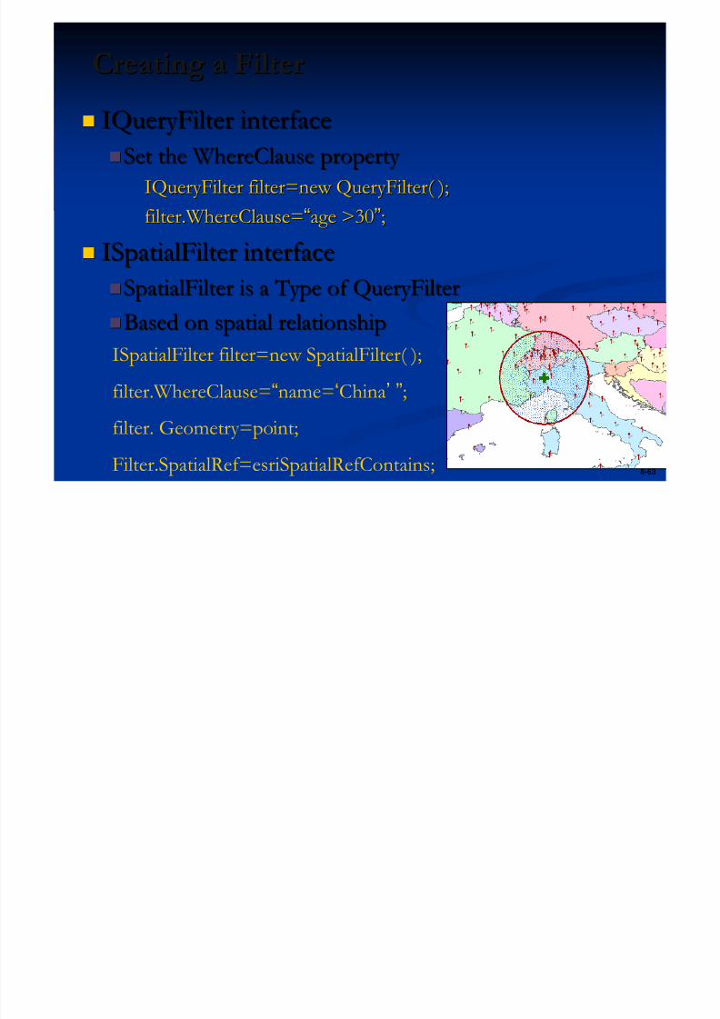
IQueryFilter interfaceIQueryFilter interface
Set the WhereClause property Set the WhereClause property
IQueryFilter filter=new QueryFilter( );IQueryFilter filter=new QueryFilter( );filter.WhereClause=filter.WhereClause=““age >30age >30””;;
ISpatialFilter interfaceISpatialFilter interface
SpatialFilter is a Type of QueryFilterSpatialFilter is a Type of QueryFilter
Based on spatial relationshipBased on spatial relationship
ISpatialFilter filter=new SpatialFilter( );
filter.WhereClause=“name=‘China’ ”;
filter. Geometry=point;
Filter.SpatialRef=esriSpatialRefContains;
Returning a Search CursorReturning a Search Cursor
5/13/2018 Developing Wtih Arcobjets10 - slidepdf.com
http://slidepdf.com/reader/full/developing-wtih-arcobjets10 64/106
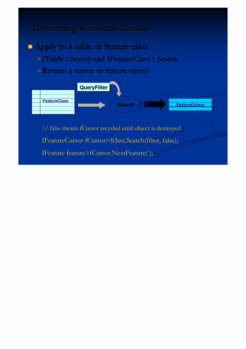
Returning a Search CursorReturning a Search Cursor
Apply to a table or feature class Apply to a table or feature class
ITable :: Search and IFeatureClass :: SearchITable :: Search and IFeatureClass :: Search
Returns a cursor or feature cursorReturns a cursor or feature cursor
FeatureClassSearch
QueryFilterQueryFilter
FeatureCursor
// false means fCursor recycled until object is destroyed
IFeatureCursor fCursor=fclass.Search(filter, false);
IFeature feature=fCursor.NextFeature( );
Exercise 04: Find Cities Based on SelectionExercise 04: Find Cities Based on Selection

5/13/2018 Developing Wtih Arcobjets10 - slidepdf.com
http://slidepdf.com/reader/full/developing-wtih-arcobjets10 65/106
Exercise 04: Find Cities Based on SelectionExercise 04: Find Cities Based on Selection
Select a country in feature layerSelect a country in feature layer
Based on the selection, query the cities whichBased on the selection, query the cities whichhas more than 2,000,000 peoplehas more than 2,000,000 people
Exercise 05: Query and AnalysisExercise 05: Query and Analysis
5/13/2018 Developing Wtih Arcobjets10 - slidepdf.com
http://slidepdf.com/reader/full/developing-wtih-arcobjets10 66/106
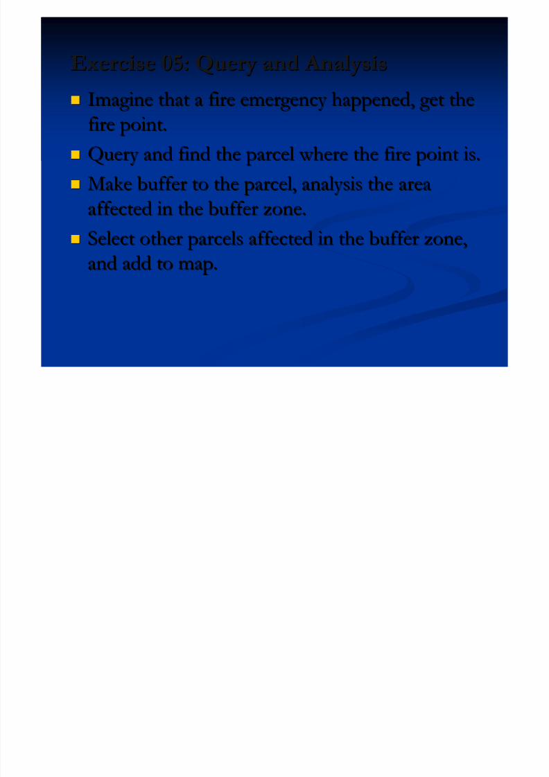
Exercise 05: Query and AnalysisExercise 05: Query and Analysis
Imagine that a fire emergency happened, get theImagine that a fire emergency happened, get the
fire point.fire point.
Query and find the parcel where the fire point is.Query and find the parcel where the fire point is.
Make buffer to the parcel, analysis the areaMake buffer to the parcel, analysis the area
affected in the buffer zone.affected in the buffer zone. Select other parcels affected in the buffer zone,Select other parcels affected in the buffer zone,
and add to map.and add to map.
Presentation OutlinePresentation Outline
5/13/2018 Developing Wtih Arcobjets10 - slidepdf.com
http://slidepdf.com/reader/full/developing-wtih-arcobjets10 67/106
Presentation OutlinePresentation Outline
Introduction of ArcObjects and .Net SDK Introduction of ArcObjects and .Net SDK
Customize and Extending ArcObjectsCustomize and Extending ArcObjects
Access Data and Display Layer Access Data and Display Layer Feature Creation and Editing Feature Creation and Editing
All Below Is Geometry All Below Is Geometry Qurey Selection and AnalysisQurey Selection and Analysis
Display and Export MapDisplay and Export Map
Deploying the Application (Engine)Deploying the Application (Engine) Extending 1: ArcGIS Raster APIsExtending 1: ArcGIS Raster APIs
Extending 2: Spatial NetWork APIsExtending 2: Spatial NetWork APIs
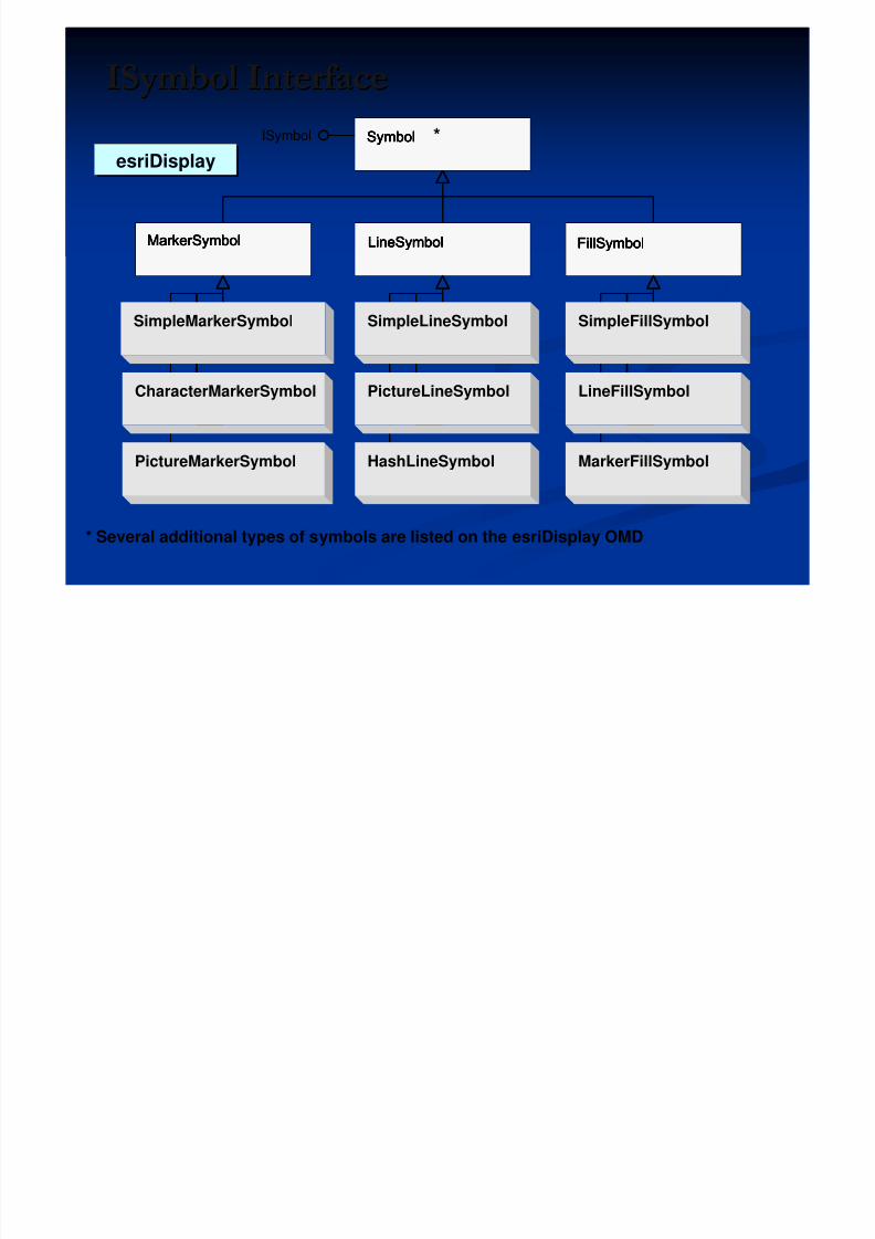
ISymbol InterfaceISymbol Interface
5/13/2018 Developing Wtih Arcobjets10 - slidepdf.com
http://slidepdf.com/reader/full/developing-wtih-arcobjets10 68/106
* Several additional types of symbols are listed on the esriDisplay OMD
ISymbol
MarkerSymbol FillSymbol LineSymbol
Symbol
SimpleMarkerSymbol
CharacterMarkerSymbol
PictureMarkerSymbol
SimpleLineSymbol
PictureLineSymbol
HashLineSymbol
SimpleFillSymbol
LineFillSymbol
MarkerFillSymbol
SymbolSymbolSymbolSymbol *
MarkerSymbolMarkerSymbolMarkerSymbolMarkerSymbol LineSymbolLineSymbolLineSymbolLineSymbol FillSymbolFillSymbolFillSymbolFillSymbol
esriDisplayesriDisplay
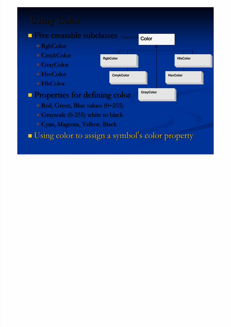
Using ColorUsing Color
5/13/2018 Developing Wtih Arcobjets10 - slidepdf.com
http://slidepdf.com/reader/full/developing-wtih-arcobjets10 69/106
Five creatable subclassesFive creatable subclasses RgbColorRgbColor
CmykColorCmykColor
GrayColorGrayColor
HsvColorHsvColor
HlsColorHlsColor
Properties for defining colorProperties for defining color Red, Green, Blue values (0Red, Green, Blue values (0 – – 255)255)
Grayscale (0Grayscale (0--255) white to black 255) white to black
Cyan, Magenta, Yellow, Black Cyan, Magenta, Yellow, Black
Using color to assign a symbolUsing color to assign a symbol’’s color property s color property
IColor Color
GrayColor
RgbColor
CmykColor
HlsColor
HsvColor
Color Color Color Color
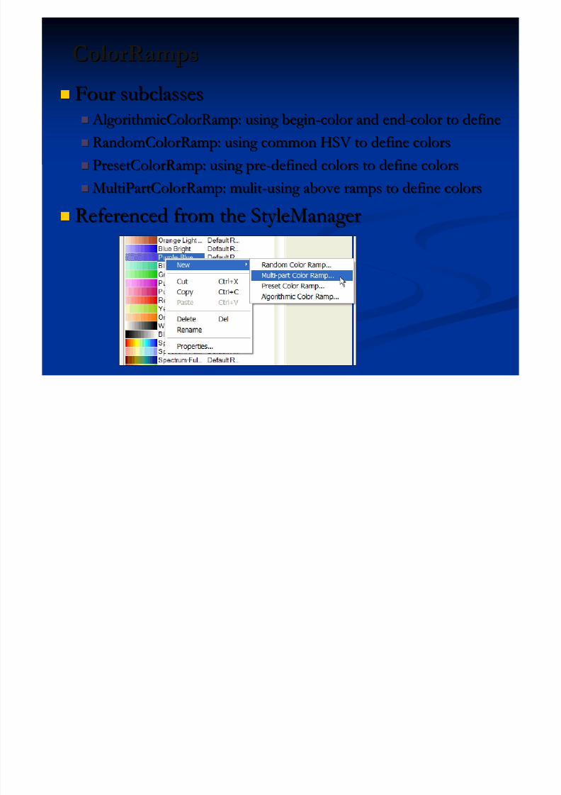
ColorRampsColorRamps
5/13/2018 Developing Wtih Arcobjets10 - slidepdf.com
http://slidepdf.com/reader/full/developing-wtih-arcobjets10 70/106
Four subclassesFour subclasses AlgorithmicColorRamp: using begin AlgorithmicColorRamp: using begin--color and endcolor and end--color to definecolor to define
RandomColorRamp: using common HSV to define colorsRandomColorRamp: using common HSV to define colors PresetColorRamp: using prePresetColorRamp: using pre--defined colors to define colorsdefined colors to define colors
MultiPartColorRamp: mulitMultiPartColorRamp: mulit--using above ramps to define colorsusing above ramps to define colors
Referenced from the StyleManagerReferenced from the StyleManager
Creating ElementsCreating Elements
5/13/2018 Developing Wtih Arcobjets10 - slidepdf.com
http://slidepdf.com/reader/full/developing-wtih-arcobjets10 71/106
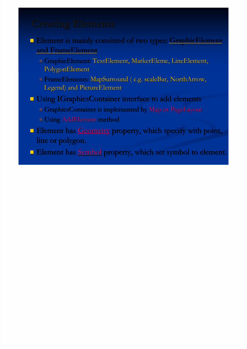
Element is mainly consisted of two types:Element is mainly consisted of two types: GraphicElementGraphicElement
and FrameElementand FrameElement
GraphicElement:GraphicElement: TextElement, MarkerEleme, LineElement, TextElement, MarkerEleme, LineElement,
PolygonElementPolygonElement
FrameElements:FrameElements: MapSurround ( e.g. scaleBar, NorthArrow,MapSurround ( e.g. scaleBar, NorthArrow,
Legend) and PictureElementLegend) and PictureElement
Using IGraphicsContainer interface to add elementsUsing IGraphicsContainer interface to add elements GraphicsContainer is implemented by GraphicsContainer is implemented by Map or PageLayoutMap or PageLayout
Using Using AddElement AddElement methodmethod
Element hasElement has Geometry Geometry property, which specify with point,property, which specify with point,
line or polygon.line or polygon.
Element hasElement has SymbolSymbol property, which set symbol to element.property, which set symbol to element.
Sample: Create Element and Assign SymbolSample: Create Element and Assign Symbol

5/13/2018 Developing Wtih Arcobjets10 - slidepdf.com
http://slidepdf.com/reader/full/developing-wtih-arcobjets10 72/106
p g yp g y
IMarkerElement maker = new MarkerElement( );
ISimpleMarkerSymbol sym=new SimpleMarkerSymbol( );
sym.Style=esriSimpleMarkerStyle.esriSMSCircle;
IRgbColor color =new RgbColor( );
color.RGB=RGB (255,255, 0);
sym.Color = color;
marker.Symbol = sym
//make new color
//make it yellow
//set color to symbol
//assign to marker
Sample: Define a Position and Add to MapSample: Define a Position and Add to Map
5/13/2018 Developing Wtih Arcobjets10 - slidepdf.com
http://slidepdf.com/reader/full/developing-wtih-arcobjets10 73/106
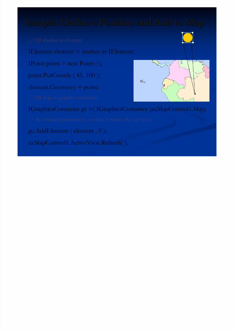
// QI marker to element
IElement element = marker as IElement;
IPoint point = new Point ( );
point.PutCoords ( 45, 100 );
element.Geometry = point;
// QI map to graphics container
IGraphicsContainer gc =( IGraphicsContainer )axMapControl1.Map;
// the second parameter is z-order, 0 means the top layer
gc.AddElement ( element , 0 );
axMapControl1.ActiveView.Refresh( );
FeatureRenderersFeatureRenderers
5/13/2018 Developing Wtih Arcobjets10 - slidepdf.com
http://slidepdf.com/reader/full/developing-wtih-arcobjets10 74/106
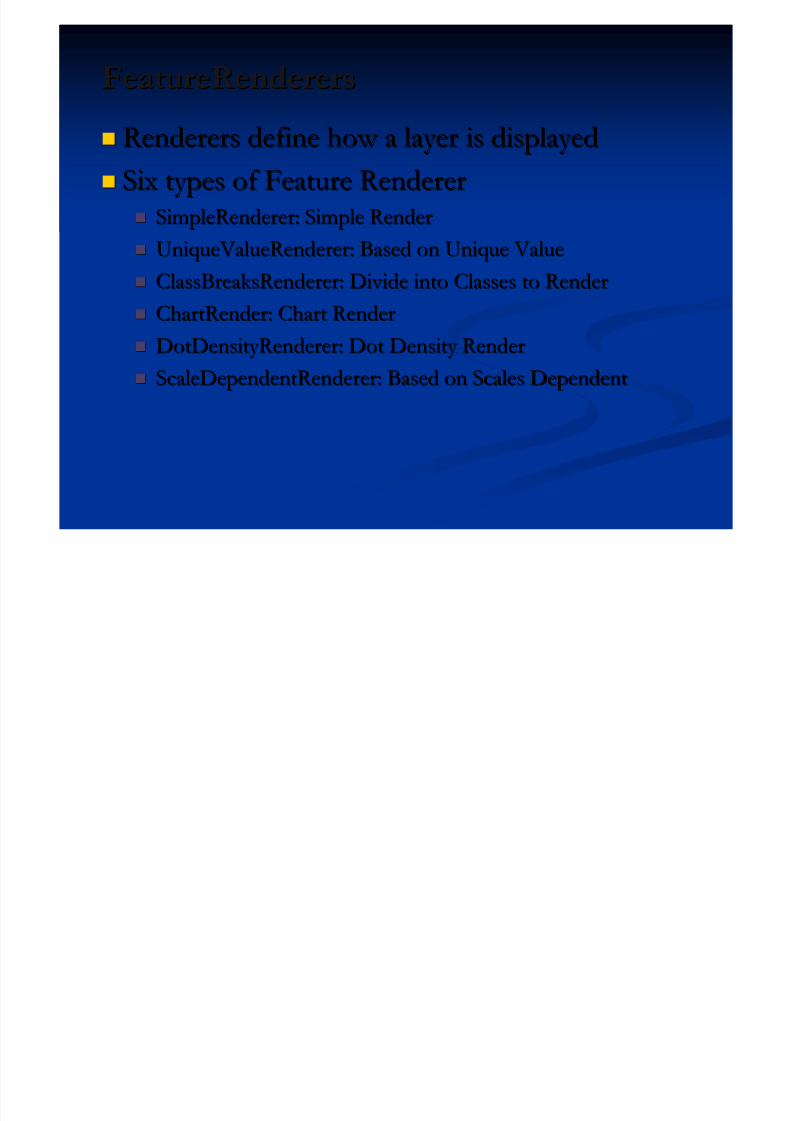
Renderers define how a layer is displayedRenderers define how a layer is displayed
Six types of Feature RendererSix types of Feature Renderer SimpleRenderer: Simple RenderSimpleRenderer: Simple Render
UniqueValueRenderer: Based on Unique ValueUniqueValueRenderer: Based on Unique Value
ClassBreaksRenderer: Divide into Classes to RenderClassBreaksRenderer: Divide into Classes to Render
ChartRender: Chart RenderChartRender: Chart Render DotDensityRenderer: Dot Density RenderDotDensityRenderer: Dot Density Render
ScaleDependentRenderer: Based on Scales DependentScaleDependentRenderer: Based on Scales Dependent
ScaleDependentRendererScaleDependentRenderer
5/13/2018 Developing Wtih Arcobjets10 - slidepdf.com
http://slidepdf.com/reader/full/developing-wtih-arcobjets10 75/106
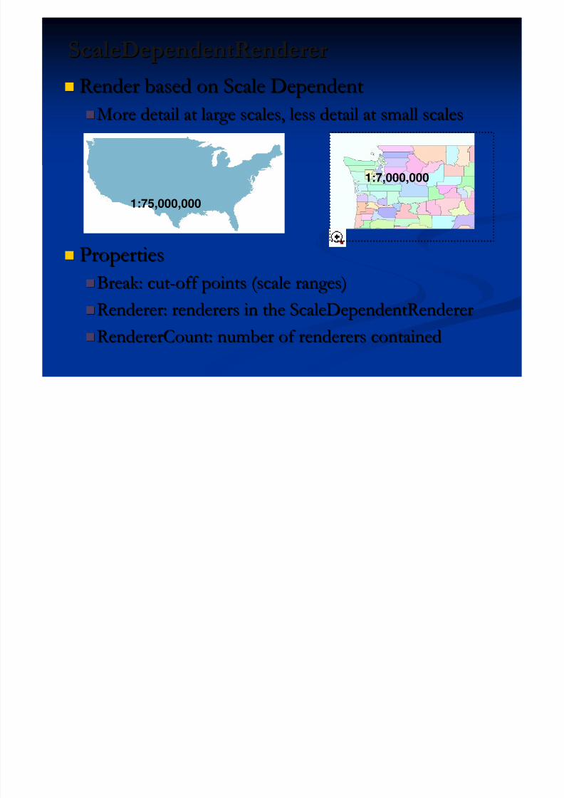
Render based on Scale DependentRender based on Scale DependentMore detail at large scales, less detail at small scalesMore detail at large scales, less detail at small scales
PropertiesProperties
Break: cutBreak: cut--off points (scale ranges)off points (scale ranges)Renderer: renderers in the ScaleDependentRendererRenderer: renderers in the ScaleDependentRenderer
RendererCount: number of renderers containedRendererCount: number of renderers contained
1:75,000,000
1:7,000,000
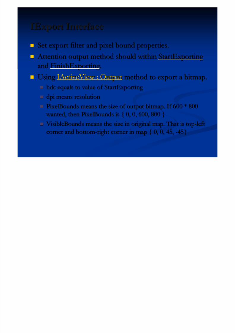
IExport InterfaceIExport Interface
5/13/2018 Developing Wtih Arcobjets10 - slidepdf.com
http://slidepdf.com/reader/full/developing-wtih-arcobjets10 76/106
pp
Set export filter and pixel bound properties.Set export filter and pixel bound properties.
Attention output method should within Attention output method should within StartExporting StartExporting
andand FinishExporting FinishExporting ..
Using Using IActiveView : OutputIActiveView : Output method to export a bitmap.method to export a bitmap.
hdc equals to value of StartExporting hdc equals to value of StartExporting
dpi means resolutiondpi means resolution
PixelBounds means the size of output bitmap. If 600 * 800PixelBounds means the size of output bitmap. If 600 * 800
wanted, then PixelBounds is { 0, 0, 600, 800 } wanted, then PixelBounds is { 0, 0, 600, 800 }
VisibleBounds means the size in original map. That is top VisibleBounds means the size in original map. That is top--leftleftcorner and bottomcorner and bottom--right corner in map { 0, 0, 45,right corner in map { 0, 0, 45, --45}45}
Sample: Export a fix location JPGSample: Export a fix location JPG

5/13/2018 Developing Wtih Arcobjets10 - slidepdf.com
http://slidepdf.com/reader/full/developing-wtih-arcobjets10 77/106
IExport export = new ExportJPEGClass(); // JPEG Exportexport.Resolution = 96; // DPI, Resolution
ESRI.ArcGIS.Display.tagRECT exportRECT = new tagRECT();// PixelBounds 512 * 512
IEnvelope envelope = newEnvelopeClass();envelope.PutCoords(0,0, 512,512);
export.PixelBounds = envelope;// Export Scale Lon: 0 – 45 and Lat: 0 - 45
IEnvelope envelope2 = new EnvelopeClass();envelope2.PutCoords(0, 0, 45, 45);// Start Exporting
Int32 hDC = export.StartExporting();
activeView.Output(hDC, (System.Int16)export.Resolution, ref exportRECT,envelope2, null); // Export Data
export.ExportFileName = “actc.jpg";export.FinishExporting(); // Finish Exporting
export.Cleanup(); // Release and Clean
Exercise 06: Complete Overview FunctionExercise 06: Complete Overview Function

5/13/2018 Developing Wtih Arcobjets10 - slidepdf.com
http://slidepdf.com/reader/full/developing-wtih-arcobjets10 78/106
pp
Associate two MapControl Associate two MapControl
Code into axMapControl1_OnExtentUpdated andCode into axMapControl1_OnExtentUpdated and
axMapControl2_onMouseDown Event.axMapControl2_onMouseDown Event.
Set overview symbol display Set overview symbol display
Presentation OutlinePresentation Outline
5/13/2018 Developing Wtih Arcobjets10 - slidepdf.com
http://slidepdf.com/reader/full/developing-wtih-arcobjets10 79/106
Introduction of ArcObjects and .Net SDK Introduction of ArcObjects and .Net SDK Customize and Extending ArcObjectsCustomize and Extending ArcObjects
Access Data and Display Layer Access Data and Display Layer
Feature Creation and Editing Feature Creation and Editing
All Below Is Geometry All Below Is Geometry
Qurey Selection and AnalysisQurey Selection and Analysis Display and Export MapDisplay and Export Map
Deploying the Application (Engine)Deploying the Application (Engine) Extending 1: ArcGIS Raster APIsExtending 1: ArcGIS Raster APIs
Extending 2: Spatial NetWork APIsExtending 2: Spatial NetWork APIs
Extending 3: ArcGIS Server Flex APIsExtending 3: ArcGIS Server Flex APIs
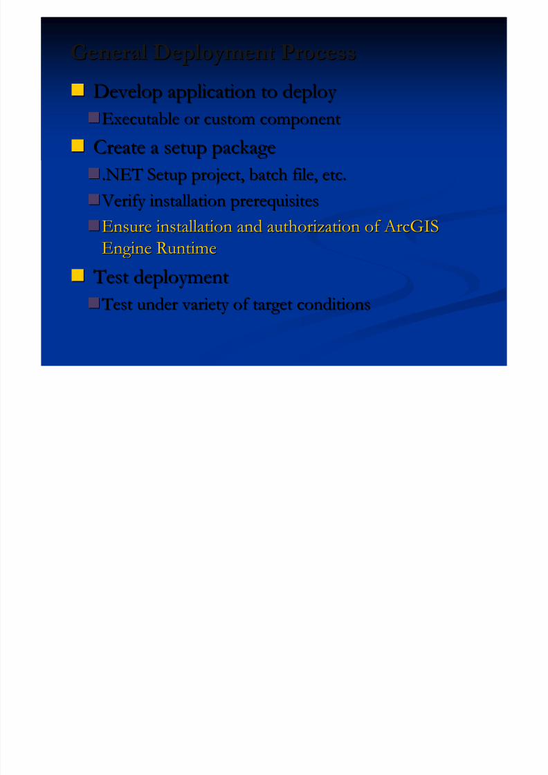
General Deployment ProcessGeneral Deployment Process
5/13/2018 Developing Wtih Arcobjets10 - slidepdf.com
http://slidepdf.com/reader/full/developing-wtih-arcobjets10 80/106
Develop application to deploy Develop application to deploy
Executable or custom componentExecutable or custom component
Create a setup packageCreate a setup package .NET Setup project, batch file, etc..NET Setup project, batch file, etc.
Verify installation prerequisites Verify installation prerequisites
Ensure installation and authorization of ArcGISEnsure installation and authorization of ArcGIS
Engine RuntimeEngine Runtime
Test deployment Test deployment Test under variety of target conditions Test under variety of target conditions
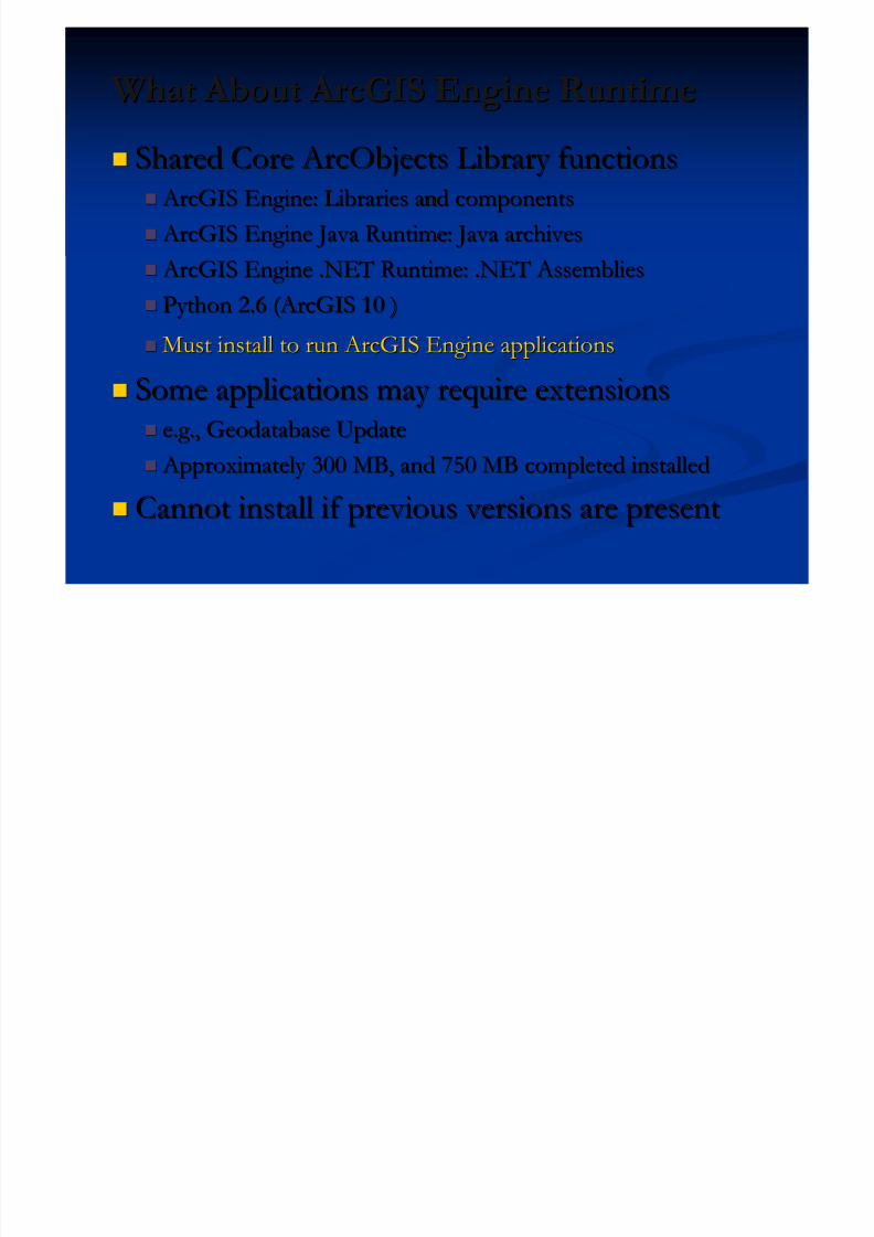
What About ArcGIS Engine RuntimeWhat About ArcGIS Engine Runtime
5/13/2018 Developing Wtih Arcobjets10 - slidepdf.com
http://slidepdf.com/reader/full/developing-wtih-arcobjets10 81/106
Shared Core ArcObjects Library functionsShared Core ArcObjects Library functions ArcGIS Engine: Libraries and components ArcGIS Engine: Libraries and components
ArcGIS Engine Java Runtime: Java archives ArcGIS Engine Java Runtime: Java archives ArcGIS Engine .NET Runtime: .NET Assemblies ArcGIS Engine .NET Runtime: .NET Assemblies
Python 2.6 (ArcGIS 10 )Python 2.6 (ArcGIS 10 )
Must install to run ArcGIS Engine applicationsMust install to run ArcGIS Engine applications
Some applications may require extensionsSome applications may require extensions e.g., Geodatabase Updatee.g., Geodatabase Update
Approximately 300 MB, and 750 MB completed installed Approximately 300 MB, and 750 MB completed installed
Cannot install if previous versions are presentCannot install if previous versions are present
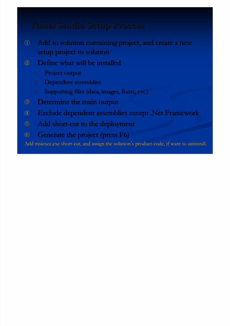
Visual Studio Setup Process Visual Studio Setup Process
5/13/2018 Developing Wtih Arcobjets10 - slidepdf.com
http://slidepdf.com/reader/full/developing-wtih-arcobjets10 82/106
①① Add to solution containing project, and create a new Add to solution containing project, and create a new
setup project to solutionsetup project to solution
②② Define what will be installedDefine what will be installed①① Project outputProject output
②② Dependent assembliesDependent assemblies
③③ Supporting files (data, images, fonts, etc.)Supporting files (data, images, fonts, etc.)
③③ Determine the main outputDetermine the main output
④④ Exclude dependent assemblies except .Net Framework Exclude dependent assemblies except .Net Framework
⑤⑤ Add short Add short--cut to the deploymentcut to the deployment
⑥⑥ Generate the project (press F6)Generate the project (press F6) Add msiexec.exe short Add msiexec.exe short--cut, and assign the solutioncut, and assign the solution’’s products product--code, if want to uninstall.code, if want to uninstall.
Presentation OutlinePresentation Outline
5/13/2018 Developing Wtih Arcobjets10 - slidepdf.com
http://slidepdf.com/reader/full/developing-wtih-arcobjets10 83/106
Introduction of ArcObjects and .Net SDK Introduction of ArcObjects and .Net SDK Customize and Extending ArcObjectsCustomize and Extending ArcObjects
Access Data and Display Layer Access Data and Display Layer Feature Creation and Editing Feature Creation and Editing
All Below Is Geometry All Below Is Geometry
Qurey Selection and AnalysisQurey Selection and Analysis
Display and Export MapDisplay and Export Map
Deploying the Application (Engine)Deploying the Application (Engine)
Extending 1: ArcGIS Raster APIsExtending 1: ArcGIS Raster APIs
Extending 2: Spatial NetWork APIsExtending 2: Spatial NetWork APIs
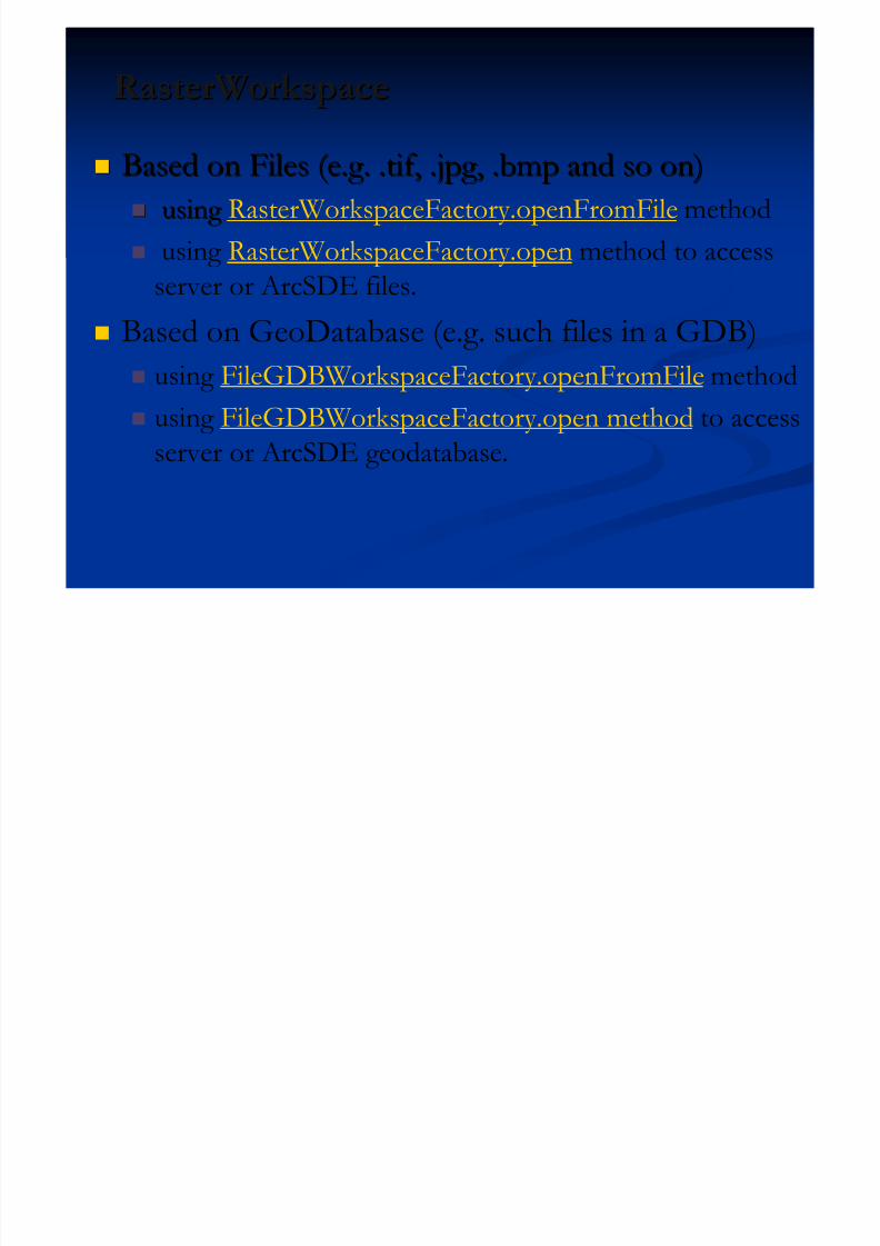
RasterWorkspaceRasterWorkspace
5/13/2018 Developing Wtih Arcobjets10 - slidepdf.com
http://slidepdf.com/reader/full/developing-wtih-arcobjets10 84/106
Based on Files (e.g. .tif, .jpg, .bmp and so on)Based on Files (e.g. .tif, .jpg, .bmp and so on)
using using RasterWorkspaceFactory.openFromFile method
using RasterWorkspaceFactory.open method to access
server or ArcSDE files.
Based on GeoDatabase (e.g. such files in a GDB) using FileGDBWorkspaceFactory.openFromFile method
using FileGDBWorkspaceFactory.open method to access
server or ArcSDE geodatabase.
RasterDataset ObjectRasterDataset Object

5/13/2018 Developing Wtih Arcobjets10 - slidepdf.com
http://slidepdf.com/reader/full/developing-wtih-arcobjets10 85/106
The RasterDataset object represents a dataset on disk or in
a geodatabase. It is composed of one or more persistent rasterbands.
Using RasterWorkspace. CreateRasterDataset method to create anew one.
// last parameter means whether raster is on disk or in memory
rasterWs.CreateRasterDataset(name, "TIFF",origin, width, height, xCell,yCell, NumBand, rstPixelType.PT_UCHAR, spatialReference, true)
Using RasterWorkspace. OpenRasterDataset method to open a
existed one.rasterWs.CreateRasterDataset( “china .tif ” )
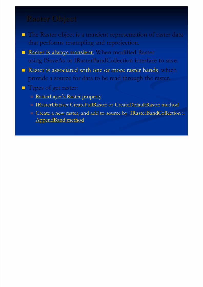
Raster ObjectRaster Object
5/13/2018 Developing Wtih Arcobjets10 - slidepdf.com
http://slidepdf.com/reader/full/developing-wtih-arcobjets10 86/106
The Raster object is a transient representation of raster data
that performs resampling and reprojection.
Raster is always transient. When modified Rasterusing ISaveAs or IRasterBandCollection interface to save.
Raster is associated with one or more raster bands, which
provide a source for data to be read through the raster. Types of get raster:
RasterLayer’s Raster property
IRasterDataset CreateFullRaster or CreateDefaultRaster method Create a new raster, and add to source by IRasterBandCollection ::
AppendBand method
RasterBand and RasterBandCollectionRasterBand and RasterBandCollection
5/13/2018 Developing Wtih Arcobjets10 - slidepdf.com
http://slidepdf.com/reader/full/developing-wtih-arcobjets10 87/106
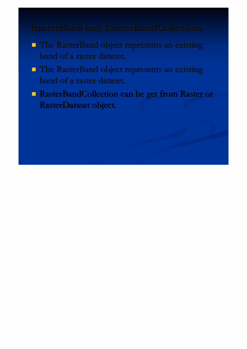
The RasterBand object represents an existing The RasterBand object represents an existing
band of a raster dataset.band of a raster dataset.
The RasterBand object represents an existing The RasterBand object represents an existing band of a raster dataset.band of a raster dataset.
RasterBandCollection can be get from Raster orRasterBandCollection can be get from Raster orRasterDataset object.RasterDataset object.
PixelBlock ObjectPixelBlock Object
Pi lBl k i i l h b d f
5/13/2018 Developing Wtih Arcobjets10 - slidepdf.com
http://slidepdf.com/reader/full/developing-wtih-arcobjets10 88/106
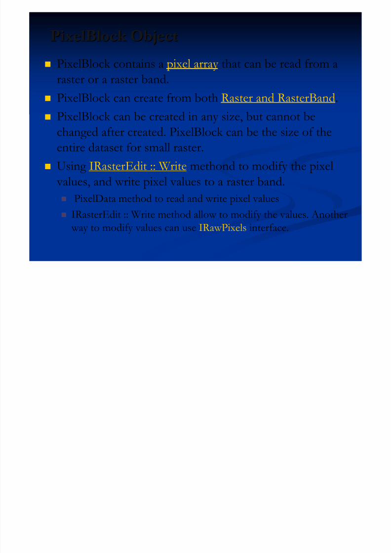
PixelBlock contains a pixel array that can be read from a
raster or a raster band.
PixelBlock can create from both Raster and RasterBand.
PixelBlock can be created in any size, but cannot be
changed after created. PixelBlock can be the size of theentire dataset for small raster.
Using IRasterEdit :: Write methond to modify the pixel
values, and write pixel values to a raster band.
PixelData method to read and write pixel values IRasterEdit :: Write method allow to modify the values. Another
way to modify values can use IRawPixels interface.
RasterProps, RasterInfo and RasterCursorRasterProps, RasterInfo and RasterCursor
5/13/2018 Developing Wtih Arcobjets10 - slidepdf.com
http://slidepdf.com/reader/full/developing-wtih-arcobjets10 89/106
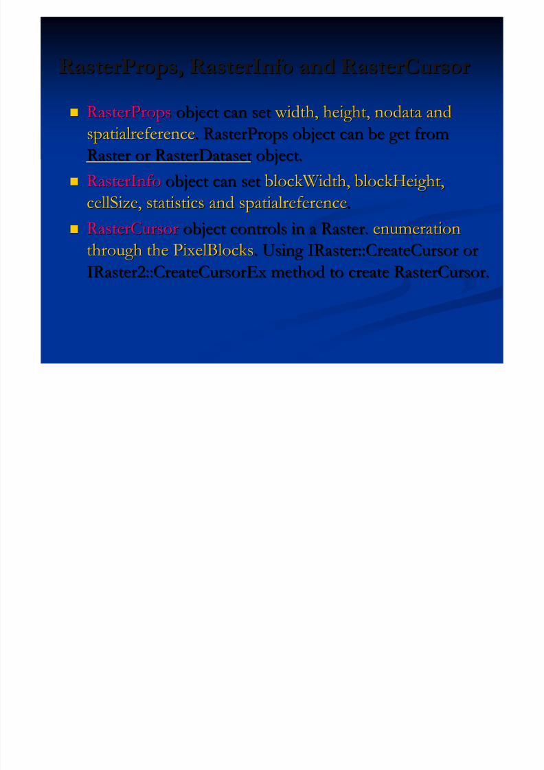
RasterPropsRasterProps object can setobject can set width, height, nodata and width, height, nodata and
spatialreferencespatialreference. RasterProps object can be get from. RasterProps object can be get from
Raster or RasterDatasetRaster or RasterDataset object.object.
RasterInfoRasterInfo object can setobject can set blockWidth, blockHeight,blockWidth, blockHeight,
cellSize, statistics and spatialreferencecellSize, statistics and spatialreference..
RasterCursorRasterCursor object controls in a Raster.object controls in a Raster. enumerationenumeration
through the PixelBlocksthrough the PixelBlocks. Using IRaster::CreateCursor or. Using IRaster::CreateCursor or
IRaster2::CreateCursorExIRaster2::CreateCursorEx method to create RasterCursor.method to create RasterCursor.
PixelFilter Object

5/13/2018 Developing Wtih Arcobjets10 - slidepdf.com
http://slidepdf.com/reader/full/developing-wtih-arcobjets10 90/106
IPixelFilter defines a simple pixel block filtering operation, which filters (changes) pixel values in place,and does not change pixel type.
Custom pixel filter would implement IPixelFilter.PansharpeningFilter(Mean) and ConvolutionFilter(e.g. 3*3 or 5*5,low pass and high pass), And Apply
to Raster to using IPixelOperation:PixelFilter
// Through PixelFilter properties below to operate pixel value
IPixelOperation pixelOp = ( IPixelOperation )raster;IPixelOperation pixelOp = ( IPixelOperation )raster;
pixelOp.PixelFilter = ( IPixelFilter )filter;pixelOp.PixelFilter = ( IPixelFilter )filter;
RasterGeometryProc Object

5/13/2018 Developing Wtih Arcobjets10 - slidepdf.com
http://slidepdf.com/reader/full/developing-wtih-arcobjets10 91/106
The RasterGeometryProc object performs geometric
processing, such as flipping, scaling, rotation, clip, merge
rectify (Format rectify), resample and mirror.
// Rotate the raster into 45 angles, and register to save
IRasterGeometryProc rasterGP = new RasterGeometryProc ();rasterGP.Rotate(null, 45, raster);
rasterGP.register(raster)
Others about Raster

5/13/2018 Developing Wtih Arcobjets10 - slidepdf.com
http://slidepdf.com/reader/full/developing-wtih-arcobjets10 92/106
SaveAs Object saves a raster or raster dataset to one of thesupported raster formats.
saveAs.SaveAs( “raster.tif", ws, "tiff"); // “tiff ” is a format
PixelOperation Object use Filter property to operate pixel values.
RasterPyramid Object controls pyramid of raster dataset through
PyramidLevel, MinimumSize, Create and BuildPyramid members. ConversionOp ObjectObject controls conversion between features andcontrols conversion between features and
raster, which is in GeoAnalysis Library.raster, which is in GeoAnalysis Library.
Presentation OutlinePresentation Outline
I t d ti f A Obj t d N t SDKI t d ti f A Obj t d N t SDK
5/13/2018 Developing Wtih Arcobjets10 - slidepdf.com
http://slidepdf.com/reader/full/developing-wtih-arcobjets10 93/106
Introduction of ArcObjects and .Net SDK Introduction of ArcObjects and .Net SDK Customize and Extending ArcObjectsCustomize and Extending ArcObjects
Access Data and Display Layer Access Data and Display Layer Feature Creation and Editing Feature Creation and Editing
All Below Is Geometry All Below Is Geometry
Qurey Selection and AnalysisQurey Selection and Analysis
Display and Export MapDisplay and Export Map
Deploying the Application (Engine)Deploying the Application (Engine) Extending 1: ArcGIS Raster APIsExtending 1: ArcGIS Raster APIs
Extending 2: Spatial NetWork APIsExtending 2: Spatial NetWork APIs
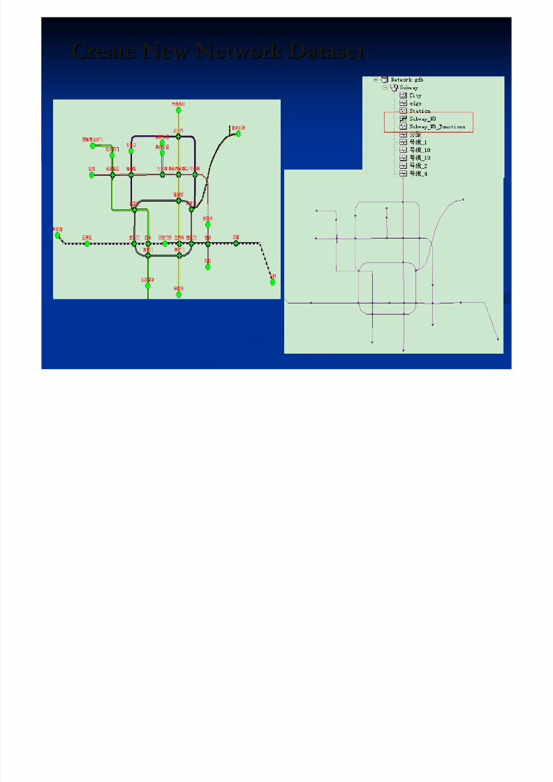
Create New Network DatasetCreate New Network Dataset
5/13/2018 Developing Wtih Arcobjets10 - slidepdf.com
http://slidepdf.com/reader/full/developing-wtih-arcobjets10 94/106
Access Network Dataset Access Network Dataset
5/13/2018 Developing Wtih Arcobjets10 - slidepdf.com
http://slidepdf.com/reader/full/developing-wtih-arcobjets10 95/106
IFeatureDatasetExtensionContainerIFeatureDatasetExtensionContainer
Access Extension Dataset Container Access Extension Dataset Container
fws.OpenFeatureDataset (featureDatasetName)fws.OpenFeatureDataset (featureDatasetName)
FindExtension method to access IDatasetContainerFindExtension method to access IDatasetContainer
NetworkDataset ObjectNetworkDataset Object
By IDatasetContainer.get_DatasetbyName methodBy IDatasetContainer.get_DatasetbyName method
NAContext ObjectNAContext Object
5/13/2018 Developing Wtih Arcobjets10 - slidepdf.com
http://slidepdf.com/reader/full/developing-wtih-arcobjets10 96/106
NAContext is the key Object in analysis.NAContext is the key Object in analysis.
Obtain references of Obtain references of NetworkDataset,NetworkDataset, NASolver,NASolver,
NAClasses, NALocatorNAClasses, NALocator Create by INASolver.CreateContext methodCreate by INASolver.CreateContext method
INAContextEdit interfaceINAContextEdit interface
Access editable properties of NAContext Access editable properties of NAContext
Bind method prepares the context for analysis basedBind method prepares the context for analysis based
on Network Dataset Schema.on Network Dataset Schema.
INASolver InterfaceINASolver Interface
INAS l i f i f ll l
5/13/2018 Developing Wtih Arcobjets10 - slidepdf.com
http://slidepdf.com/reader/full/developing-wtih-arcobjets10 97/106
INASolver interface is common for all solvers.INASolver interface is common for all solvers.
NAClosestFacilitySolverNAClosestFacilitySolver
NARouteSolverNARouteSolver NAServiceAreaSolverNAServiceAreaSolver
Two important methods Two important methods
CreateContextCreateContext method to create NAContextmethod to create NAContext
SolveSolve method returns boolean to perform analysismethod returns boolean to perform analysis
False means completed solvedFalse means completed solved True means partial solved True means partial solved
NAClass ObjectNAClass Object
H ldH ld ff i d i h l ii d i h l i

5/13/2018 Developing Wtih Arcobjets10 - slidepdf.com
http://slidepdf.com/reader/full/developing-wtih-arcobjets10 98/106
HoldsHolds featuresfeatures input or output during the analysis.input or output during the analysis.
Different solver, different NAClass nameDifferent solver, different NAClass name
If NARouteSolver:If NARouteSolver: Stops, Routes and Barriers.Stops, Routes and Barriers.
If NAClosestFacilitySolver:If NAClosestFacilitySolver: Facilities, Incidents,Facilities, Incidents,
CFRoutes and Barriers.CFRoutes and Barriers.
Attention: these words can Attention: these words can’’t be changed!t be changed!
INAClassLoaderINAClassLoader InterfaceInterface
TheThe LocatorLocator property specifies how networkproperty specifies how network

5/13/2018 Developing Wtih Arcobjets10 - slidepdf.com
http://slidepdf.com/reader/full/developing-wtih-arcobjets10 99/106
The The LocatorLocator property specifies how network property specifies how network
locations will be found.locations will be found.
LoadLoad method returns features based onmethod returns features based onFeatureCursor and located locationsFeatureCursor and located locations
Add Analysis Result to MapControl Add Analysis Result to MapControl

5/13/2018 Developing Wtih Arcobjets10 - slidepdf.com
http://slidepdf.com/reader/full/developing-wtih-arcobjets10 100/106
Use ISolver.Solve method to perform analysisUse ISolver.Solve method to perform analysis
In NAClass Routes or CFRoutes represent the solvedIn NAClass Routes or CFRoutes represent the solved
result.result.
QI NAClass to FeatureClassQI NAClass to FeatureClass
Add FeatureClass to MapControl Add FeatureClass to MapControl
Analysis Result Analysis Result
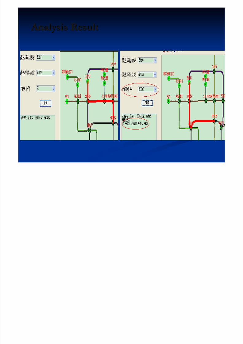
5/13/2018 Developing Wtih Arcobjets10 - slidepdf.com
http://slidepdf.com/reader/full/developing-wtih-arcobjets10 101/106
Developer TopicsDeveloper Topics

5/13/2018 Developing Wtih Arcobjets10 - slidepdf.com
http://slidepdf.com/reader/full/developing-wtih-arcobjets10 102/106
About Future About Future
About Developer Career About Developer Career
ArcGIS Server ArcGIS Server

5/13/2018 Developing Wtih Arcobjets10 - slidepdf.com
http://slidepdf.com/reader/full/developing-wtih-arcobjets10 103/106
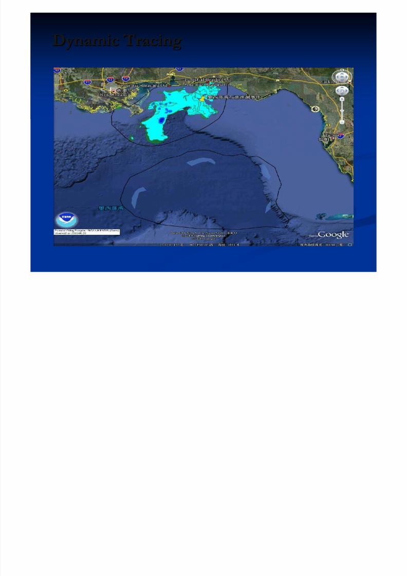
Dynamic TracingDynamic Tracing
5/13/2018 Developing Wtih Arcobjets10 - slidepdf.com
http://slidepdf.com/reader/full/developing-wtih-arcobjets10 104/106
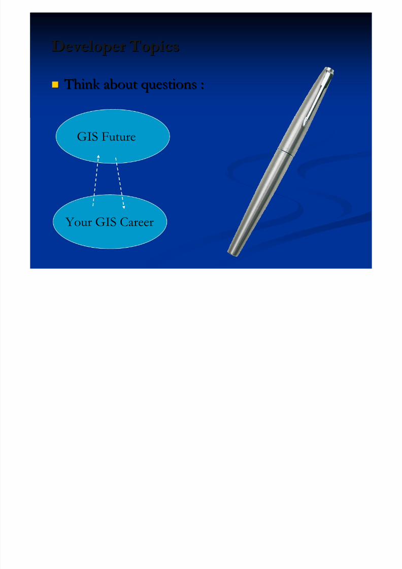
Developer TopicsDeveloper Topics
5/13/2018 Developing Wtih Arcobjets10 - slidepdf.com
http://slidepdf.com/reader/full/developing-wtih-arcobjets10 105/106
Think about questions : Think about questions :
GIS Future
Your GIS Career

5/13/2018 Developing Wtih Arcobjets10 - slidepdf.com
http://slidepdf.com/reader/full/developing-wtih-arcobjets10 106/106
Thank you for your listening! Thank you for your listening!
[email protected]@gmail.com


![[1C7] Developing with Oculus](https://static.fdocument.pub/doc/165x107/547e899f5806b5db5e8b46e4/1c7-developing-with-oculus.jpg)