Comparison of morphogenetic features of the Nepal Himalaya...
9
31. srpna – 3. září 2010 Ostrava http://konference.osu.cz/cgsostrava2010 59 Comparison of morphogenetic features of the Nepal Himalaya with the Earth Gravitational Model 2008 Korelace morfogenetických stylů Nepálského Himálaje s modelem gravitačního pole Země 08 Jan KALVODA a , Jaroslav KLOKOČNÍK b , Jan KOSTELECKÝ c a Univerzita Karlova v Praze, [email protected] b Astronomický ústav Akademie věd České republiky c České vysoké učení technické v Praze Abstract The paper presents a comparison of regional morphogenetic features and orographical patterns of the Nepal Himalaya with selected quantities of the Earth Gravitational Model 2008 (EGM 08). Coincidences between morphogenetic phenomena of the Nepal Himalaya and the extension of regions with very high positive values of the radial second derivative of the disturbing gravitational potential T rr and the most likely in combination with conspicuous areas of high negative values of T rr in their close neighbourhood have been detected. These variable values of T rr display significant gravitational signatures of conspicuous differences and changes in mass density and/or rock massif and regolith distributions, which occurred during very dynamic landform evolution in the late Cenozoic. It is suggested that Himalayan regions with the occurrence of conspicuous combinations of significantly high positive or negative values of radial second derivatives of the disturbing gravitational potential T rr are characterized by extremely active geomorphic processes. Keywords: landform evolution, Earth Gravitational Model 08, collision orogeny, Himalaya. Klíčová slova: vývoj povrchových tvarů, model gravitačního pole Země, kolizní orogeneze, Nepálský Himálaj 1. Introduction The comparison of regional morphogenetic features and orographical patterns of the Nepal Himalaya with the Earth Gravitational Model 2008 (EGM 2008) is presented in this paper. We computed the free-air gravity anomaly ∆g and the second radial derivative of the disturbing gravitational potential T rr over the region of the Nepal Himalayas as well as over the whole Tibet Highland and neighbouring regions (Fig. 1) for large- scale morphogenetic correlations with the landform pattern and its palaeogeographical evolution. The radial second derivatives of the disturbing gravitational potential T rr are proportional to the mean curvature of the geoid, which is determined by the actual distribution of the matter, including the configuration of landforms. Free-air gravity anomalies and second derivatives of the disturbing gravitational potential give evidence of peculiarities of the present-day Earth´s shape and its regional mass distribution as well as the intensity and integration of activities of very variable endogenous and climate-morphogenetic processes. In the paper, we focused especially on the regional distribution of the radial second derivative of the disturbing gravitational potential T rr in the Nepal Himalaya (Fig. 2). The second derivatives T rr at ground level (computed from EGM 2008) actually disclose many more details than the first derivatives of the potential and led to new possibilities of geodynamic interpretations. Regional coincidences between selected morphogenetic phenomena of the Nepal Himalaya and the extension of T rr have been identified. Recorded gravitational field signatures are reflections of the long- term landform evolution during the very dynamic collision orogeny of the Himalaya in the late Cenozoic. 2. Data and method The gravity field of the Earth is represented by a spherical harmonic expansion with harmonic geopotential coefficients to a certain degree and order in a form of the so-called “Earth gravitational model”. The data for such a model comes from satellite observations of various types and from terrestrial gravity anomalies measured by gravimeters. The National Geospatial- Intelligence Agency (NGA) of the USA has developed a new Earth Gravitational Model, called EGM 2008 (Pavlis et al. 2008 a) intended to replace the US EGM 96 model (Lemoine et al. 1998) which served as one of standards for the Earth models. EGM 2008 is a combined gravitational model. The low- frequency portion of the model comes from spaceborne data (namely from the Gravity Recovery And Climate Experiment, GRACE) and the high-frequency part comes from terrestrial and altimetry data (Huang et al. 2007; Pavlis et al. 2008 a). An important contribution to EGM 2008 has been made by the terrestrial 5’ x 5’ (arcminute)
Transcript of Comparison of morphogenetic features of the Nepal Himalaya...
31. srpna – 3. září 2010 Ostrava http://konference.osu.cz/cgsostrava2010
59
Comparison of morphogenetic features of the Nepal Himalaya with the Earth Gravitational Model 2008 Korelace morfogenetických stylů Nepálského Himálaje s modelem gravitačního pole Země 08 Jan KALVODAa, Jaroslav KLOKOČNÍKb, Jan KOSTELECKÝc aUniverzita Karlova v Praze, [email protected] bAstronomický ústav Akademie věd České republiky cČeské vysoké učení technické v Praze Abstract The paper presents a comparison of regional morphogenetic features and orographical patterns of the Nepal Himalaya with selected quantities of the Earth Gravitational Model 2008 (EGM 08). Coincidences between morphogenetic phenomena of the Nepal Himalaya and the extension of regions with very high positive values of the radial second derivative of the disturbing gravitational potential Trr and the most likely in combination with conspicuous areas of high negative values of Trr in their close neighbourhood have been detected. These variable values of Trr display significant gravitational signatures of conspicuous differences and changes in mass density and/or rock massif and regolith distributions, which occurred during very dynamic landform evolution in the late Cenozoic. It is suggested that Himalayan regions with the occurrence of conspicuous combinations of significantly high positive or negative values of radial second derivatives of the disturbing gravitational potential Trr are characterized by extremely active geomorphic processes. Keywords: landform evolution, Earth Gravitational Model 08, collision orogeny, Himalaya. Klíčová slova: vývoj povrchových tvarů, model gravitačního pole Země, kolizní orogeneze, Nepálský Himálaj 1. Introduction The comparison of regional morphogenetic features and orographical patterns of the Nepal Himalaya with the Earth Gravitational Model 2008 (EGM 2008) is presented in this paper. We computed the free-air gravity anomaly ∆g and the second radial derivative of the disturbing gravitational potential Trr over the region of the Nepal Himalayas as well as over the whole Tibet Highland and neighbouring regions (Fig. 1) for large-scale morphogenetic correlations with the landform pattern and its palaeogeographical evolution. The radial second derivatives of the disturbing gravitational potential Trr are proportional to the mean curvature of the geoid, which is determined by the actual distribution of the matter, including the configuration of landforms. Free-air gravity anomalies and second derivatives of the disturbing gravitational potential give evidence of peculiarities of the present-day Earth´s shape and its regional mass distribution as well as the intensity and integration of activities of very variable endogenous and climate-morphogenetic processes. In the paper, we focused especially on the regional distribution of the radial second derivative of the disturbing gravitational potential Trr in the Nepal Himalaya (Fig. 2). The second derivatives Trr at ground level (computed from EGM 2008) actually disclose many more details than the first derivatives of the
potential and led to new possibilities of geodynamic interpretations. Regional coincidences between selected morphogenetic phenomena of the Nepal Himalaya and the extension of Trr have been identified. Recorded gravitational field signatures are reflections of the long-term landform evolution during the very dynamic collision orogeny of the Himalaya in the late Cenozoic. 2. Data and method The gravity field of the Earth is represented by a spherical harmonic expansion with harmonic geopotential coefficients to a certain degree and order in a form of the so-called “Earth gravitational model”. The data for such a model comes from satellite observations of various types and from terrestrial gravity anomalies measured by gravimeters. The National Geospatial-Intelligence Agency (NGA) of the USA has developed a new Earth Gravitational Model, called EGM 2008 (Pavlis et al. 2008 a) intended to replace the US EGM 96 model (Lemoine et al. 1998) which served as one of standards for the Earth models. EGM 2008 is a combined gravitational model. The low-frequency portion of the model comes from spaceborne data (namely from the Gravity Recovery And Climate Experiment, GRACE) and the high-frequency part comes from terrestrial and altimetry data (Huang et al. 2007; Pavlis et al. 2008 a). An important contribution to EGM 2008 has been made by the terrestrial 5’ x 5’ (arcminute)
31. srpna – 3. září 2010 Ostrava http://konference.osu.cz/cgsostrava2010
60
mean free-air gravity anomalies derived from gravimetric measurements on surface of continents and oceans and anomalies derived from satellite altimetry over the oceans, almost worldwide. Their precision is usually a few miligals (e.g. Huang et al. 2007; Pavlis et al. 2008b; Klokočník et al. 2008, 2010) which is also true for the commission error of the gravity anomalies computed from the EGM 2008 harmonic coefficients. We made use of generic software for ‘gravitational synthesis’ (Holmes and Pavlis 2006). The program computes the gravity anomalies and the first and second derivatives of the gravitational potential. The following quantities are actually computed for our applications: A) The free-air gravity anomaly ∆g is approximately equal to the first radial derivative of the disturbing gravity potential. It is defined through the fundamental gravimetric equation and in spherical approximation reads as follows
max
2
2
2,1,,
2,,
nn
n
Tr
Rn
R
GMrT
rrrg
(1)
where R is a scale factor of the EGM 2008 and ,nT
is an approximation of Tn (component of T) by spherical functions, n is the degree of harmonic expansion, (θ, λ) are co-latitude and longitude. B) The second radial derivative of the disturbing gravitational potential in spherical approximation is
max
2
3
32
2
,21,,,,n
n
n
rr Tr
Rnn
R
GMrT
rrT
(2) With
cossincos, ,0
,, mn
n
mmnmnn PmSmCT
where Cn,m and Sn,m are harmonic geopotential coefficients (Stokes parameters) from EGM 08 and Pn,m are associated Legendre functions. Here for EGM 2008 we have nmax= 2190. In all presented figures with presentations of ∆g (Fig. 3) and Trr (Figs. 1 and 4) non-linear scales are used to emphasize the signal and the zero value of the computed quantities is always in green. The units for free-air gravity anomalies (∆g) are 1 mGal (or miligal) = 10-5 ms-
2, and those for second radial derivatives of the disturbing gravitational potential(Trr) are 1 E = 1 Eötvös = 10-12 s-2. 3. Results Graphical interpretation of the extension of second radial derivative of the disturbing gravitational potential Trr
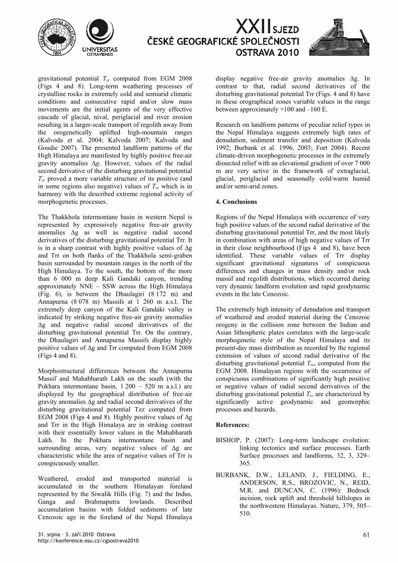
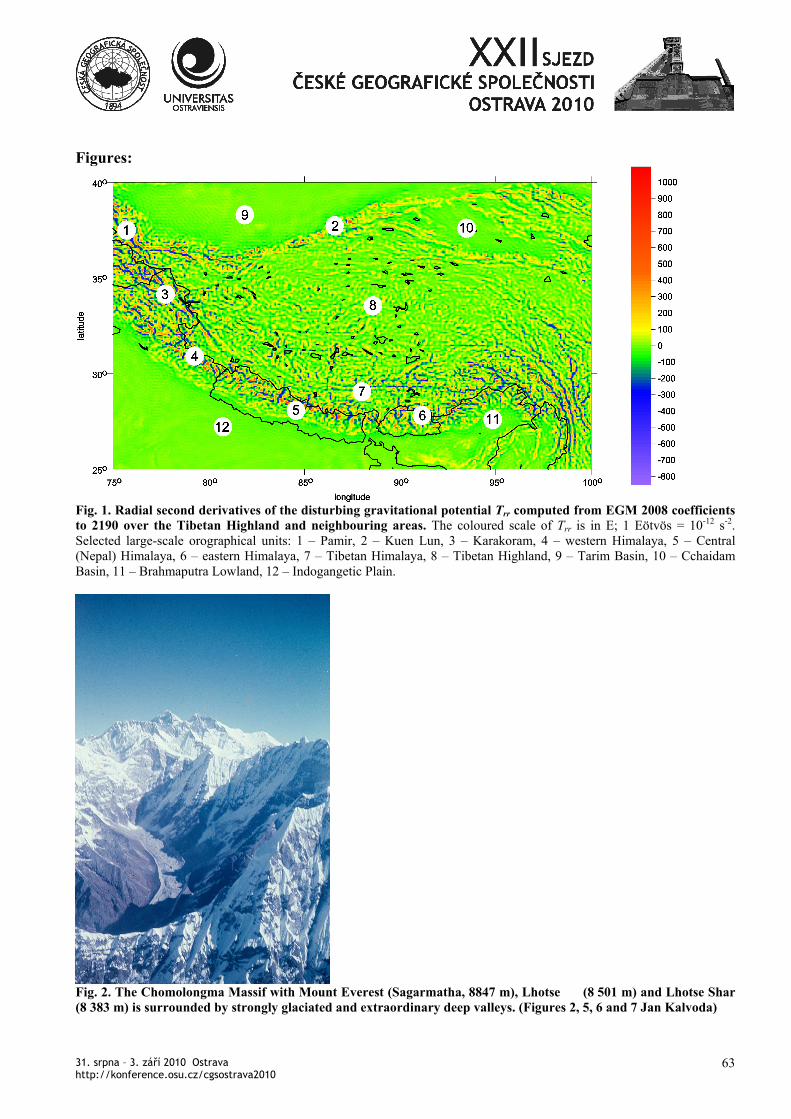
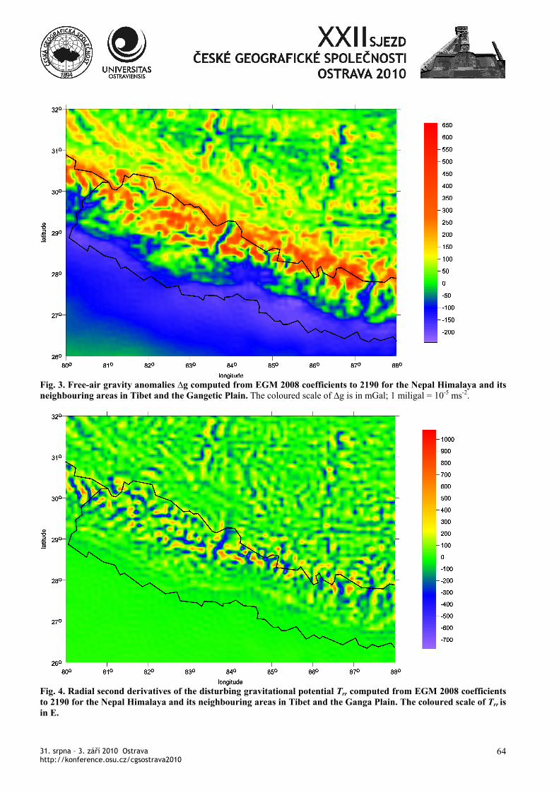
clearly express the main orographical features of the Tibetan Highland and surrounding areas (Fig. 1). Large-scale distribution of ridges, valleys or intermountain basins and an eccentric bending of the river network east of the Himalaya are very remarkable (Kalvoda et al., in print, Klokočník et al. in review). In the Himalayan mountain ranges and the Tibetan Highland positive gravity free-air anomalies ∆g computed from EGM 2008 expressively predominate (Fig. 3), and negative gravity free-air anomalies ∆g are typical for the Indogangetic Plain and Siwalik Hills. Areas with very high positive and negative values of the radial second derivative of the disturbing potential Trr computed from EGM 08 (Figs. 1 and 4) are found especially in central parts of the Himalaya and the Karakoram. High-mountain reliefs of the Nepal Himalaya are manifested by outstanding positive free-air gravity anomalies ∆g and mostly positive radial second derivatives of the disturbing gravitational potential Trr
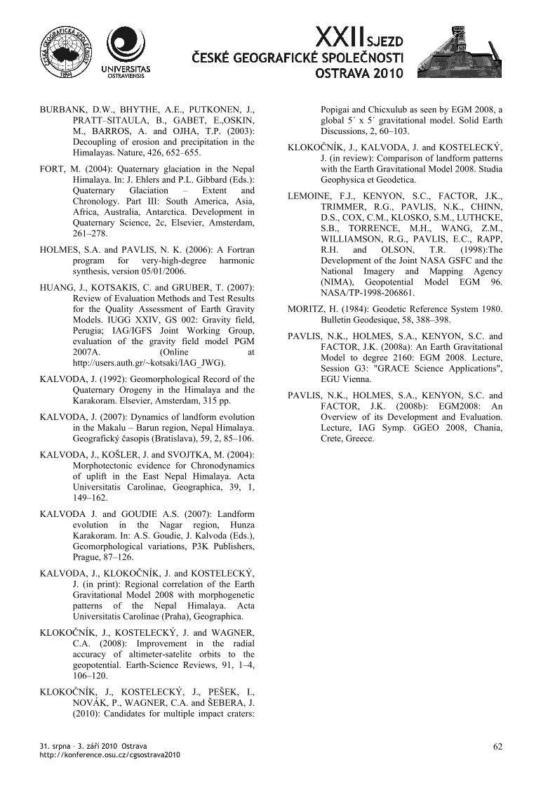
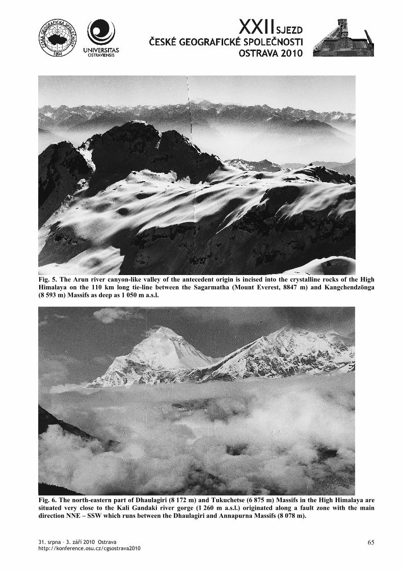
computed from EGM 2008 (Figs. 3 and 4). The Nepal Himalaya have not yet attained isostatic equilibrium, since the endogenous processes producing their uplift are more active than erosion and denudation (e.g. Burbank et al. 2003, Bishop 2007). In the Nepal Himalaya, it is evident that there is a large range of values of ∆g approximately between +660 and –260 mGal (Fig. 3) in comparison with those of the High Himalaya (the Great Himalayan Range) and the Gangetic Plain. Moreover, rapid landform evolution in the Nepal Himalaya is indicated not only by a large range of values of Trr approximately between +1100 and –700 E (Fig. 4), but also, especially, by its specific configuration and sharp differences in orographical and morphogenetic positions. The main morphogenetically conspicuous types of the space configuration of values of the radial second derivative of the disturbing gravitational potential Trr have been identified with large-scale regional landform patterns of the Nepal Himalaya. For example, the Chomolongma Massif with Mount Everest (Sagarmatha, 8847 m), Lhotse (8 501 m) and Lhotse Shar (8 383 m) is situated in the central part of the strongly glaciated regions of the Rongbuk, Karma, Barun, Imja and Khumbu valleys (Fig. 2). It is a region of very high positive free-air gravity anomalies ∆g and also positive radial second derivatives of the disturbing gravitational potential Trr. On the contrary, negative values of Trr, which are detected in the south of the Chomolongma Massif (Fig. 4), follow the very deep canyon of the Dudh Kosi river in the High Himalaya. The Arun river valley deeply cuts through the High Himalaya mountain ranges in the East Nepal (Fig. 5). The extremely deep canyon of the Arun river and similar valley networks in its neighbourhood is indicated by striking negative free-air gravity anomalies ∆g and negative radial second derivatives of the disturbing
31. srpna – 3. září 2010 Ostrava http://konference.osu.cz/cgsostrava2010
61
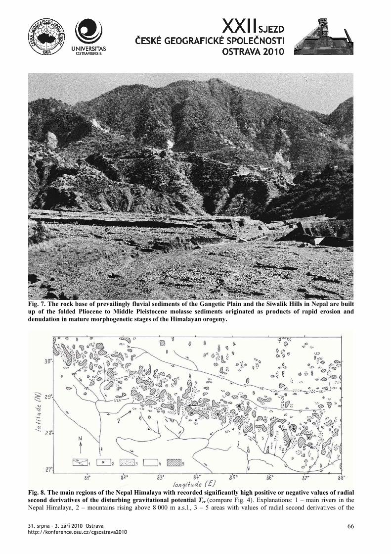
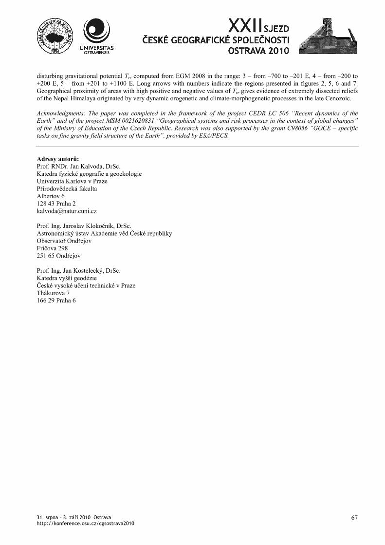
gravitational potential Trr computed from EGM 2008 (Figs 4 and 8). Long-term weathering processes of crystalline rocks in extremely cold and semiarid climatic conditions and consecutive rapid and/or slow mass movements are the initial agents of the very effective cascade of glacial, nival, periglacial and river erosion resulting in a larger-scale transport of regolith away from the orogenetically uplifted high-mountain ranges (Kalvoda et al. 2004; Kalvoda 2007; Kalvoda and Goudie 2007). The presented landform patterns of the High Himalaya are manifested by highly positive free-air gravity anomalies ∆g. However, values of the radial second derivative of the disturbing gravitational potential Trr proved a more variable structure of its positive (and in some regions also negative) values of Trr which is in harmony with the described extreme regional activity of morphogenetic processes. The Thakkhola intermontane basin in western Nepal is represented by expressively negative free-air gravity anomalies ∆g as well as negative radial second derivatives of the disturbing gravitational potential Trr. It is in a sharp contrast with highly positive values of ∆g and Trr on both flanks of the Thakkhola semi-graben basin surrounded by mountain ranges in the north of the High Himalaya. To the south, the bottom of the more than 6 000 m deep Kali Gandaki canyon, trending approximately NNE – SSW across the High Himalaya (Fig. 6), is between the Dhaulagiri (8 172 m) and Annapurna (8 078 m) Massifs at 1 260 m a.s.l. The extremely deep canyon of the Kali Gandaki valley is indicated by striking negative free-air gravity anomalies ∆g and negative radial second derivatives of the disturbing gravitational potential Trr. On the contrary, the Dhaulagiri and Annapurna Massifs display highly positive values of ∆g and Trr computed from EGM 2008 (Figs 4 and 8). Morphostructural differences between the Annapurna Massif and Mahabharath Lakh on the south (with the Pokhara intermontane basin, 1 200 – 520 m a.s.l.) are displayed by the geographical distribution of free-air gravity anomalies ∆g and radial second derivatives of the disturbing gravitational potential Tzz computed from EGM 2008 (Figs 4 and 8). Highly positive values of ∆g and Trr in the High Himalaya are in striking contrast with their essentially lower values in the Mahabharath Lakh. In the Pokhara intermontane basin and surrounding areas, very negative values of ∆g are characteristic while the area of negative values of Trr is conspicuously smaller. Weathered, eroded and transported material is accumulated in the southern Himalayan foreland represented by the Siwalik Hills (Fig. 7) and the Indus, Ganga and Brahmaputra lowlands. Described accumulation basins with folded sediments of late Cenozoic age in the foreland of the Nepal Himalaya
display negative free-air gravity anomalies ∆g. In contrast to that, radial second derivatives of the disturbing gravitational potential Trr (Figs. 4 and 8) have in these orographical zones variable values in the range between approximately +100 and –160 E. Research on landform patterns of peculiar relief types in the Nepal Himalaya suggests extremely high rates of denudation, sediment transfer and deposition (Kalvoda 1992; Burbank et al. 1996, 2003; Fort 2004). Recent climate-driven morphogenetic processes in the extremely dissected relief with an elevational gradient of over 7 000 m are very active in the framework of extraglacial, glacial, periglacial and seasonally cold/warm humid and/or semi-arid zones. 4. Conclusions Regions of the Nepal Himalaya with occurrence of very high positive values of the second radial derivative of the disturbing gravitational potential Trr, and the most likely in combination with areas of high negative values of Trr in their close neighbourhood (Figs 4 and 8), have been identified. These variable values of Trr display significant gravitational signatures of conspicuous differences and changes in mass density and/or rock massif and regolith distributions, which occurred during very dynamic landform evolution and rapid geodynamic events in the late Cenozoic. The extremely high intensity of denudation and transport of weathered and eroded material during the Cenozoic orogeny in the collision zone between the Indian and Asian lithospheric plates correlates with the large-scale morphogenetic style of the Nepal Himalaya and its present-day mass distribution as recorded by the regional extension of values of second radial derivative of the disturbing gravitational potential Trr, computed from the EGM 2008. Himalayan regions with the occurrence of conspicuous combinations of significantly high positive or negative values of radial second derivatives of the disturbing gravitational potential Trr are characterized by significantly active geodynamic and geomorphic processes and hazards. References: BISHOP, P. (2007): Long-term landscape evolution:
linking tectonics and surface processes. Earth Surface processes and landforms, 32, 3, 329–365.
BURBANK, D.W., LELAND, J., FIELDING, E., ANDERSON, R.S., BROZOVIC, N., REID, M.R. and DUNCAN, C. (1996): Bedrock incision, rock uplift and threshold hillslopes in the northwestern Himalayas. Nature, 379, 505–510.
31. srpna – 3. září 2010 Ostrava http://konference.osu.cz/cgsostrava2010
62
BURBANK, D.W., BHYTHE, A.E., PUTKONEN, J., PRATT–SITAULA, B., GABET, E.,OSKIN, M., BARROS, A. and OJHA, T.P. (2003): Decoupling of erosion and precipitation in the Himalayas. Nature, 426, 652–655.
FORT, M. (2004): Quaternary glaciation in the Nepal Himalaya. In: J. Ehlers and P.L. Gibbard (Eds.): Quaternary Glaciation – Extent and Chronology. Part III: South America, Asia, Africa, Australia, Antarctica. Development in Quaternary Science, 2c, Elsevier, Amsterdam, 261–278.
HOLMES, S.A. and PAVLIS, N. K. (2006): A Fortran program for very-high-degree harmonic synthesis, version 05/01/2006.
HUANG, J., KOTSAKIS, C. and GRUBER, T. (2007): Review of Evaluation Methods and Test Results for the Quality Assessment of Earth Gravity Models. IUGG XXIV, GS 002: Gravity field, Perugia; IAG/IGFS Joint Working Group, evaluation of the gravity field model PGM 2007A. (Online at http://users.auth.gr/~kotsaki/IAG_JWG).
KALVODA, J. (1992): Geomorphological Record of the Quaternary Orogeny in the Himalaya and the Karakoram. Elsevier, Amsterdam, 315 pp.
KALVODA, J. (2007): Dynamics of landform evolution in the Makalu – Barun region, Nepal Himalaya. Geografický časopis (Bratislava), 59, 2, 85–106.
KALVODA, J., KOŠLER, J. and SVOJTKA, M. (2004): Morphotectonic evidence for Chronodynamics of uplift in the East Nepal Himalaya. Acta Universitatis Carolinae, Geographica, 39, 1, 149–162.
KALVODA J. and GOUDIE A.S. (2007): Landform evolution in the Nagar region, Hunza Karakoram. In: A.S. Goudie, J. Kalvoda (Eds.), Geomorphological variations, P3K Publishers, Prague, 87–126.
KALVODA, J., KLOKOČNÍK, J. and KOSTELECKÝ, J. (in print): Regional correlation of the Earth Gravitational Model 2008 with morphogenetic patterns of the Nepal Himalaya. Acta Universitatis Carolinae (Praha), Geographica.
KLOKOČNÍK, J., KOSTELECKÝ, J. and WAGNER, C.A. (2008): Improvement in the radial accuracy of altimeter-satelite orbits to the geopotential. Earth-Science Reviews, 91, 1–4, 106–120.
KLOKOČNÍK, J., KOSTELECKÝ, J., PEŠEK, I., NOVÁK, P., WAGNER, C.A. and ŠEBERA, J. (2010): Candidates for multiple impact craters:
Popigai and Chicxulub as seen by EGM 2008, a global 5´ x 5´ gravitational model. Solid Earth Discussions, 2, 60–103.
KLOKOČNÍK, J., KALVODA, J. and KOSTELECKÝ, J. (in review): Comparison of landform patterns with the Earth Gravitational Model 2008. Studia Geophysica et Geodetica.
LEMOINE, F.J., KENYON, S.C., FACTOR, J.K., TRIMMER, R.G., PAVLIS, N.K., CHINN, D.S., COX, C.M., KLOSKO, S.M., LUTHCKE, S.B., TORRENCE, M.H., WANG, Z.M., WILLIAMSON, R.G., PAVLIS, E.C., RAPP, R.H. and OLSON, T.R. (1998):The Development of the Joint NASA GSFC and the National Imagery and Mapping Agency (NIMA), Geopotential Model EGM 96. NASA/TP-1998-206861.
MORITZ, H. (1984): Geodetic Reference System 1980. Bulletin Geodesique, 58, 388–398.
PAVLIS, N.K., HOLMES, S.A., KENYON, S.C. and FACTOR, J.K. (2008a): An Earth Gravitational Model to degree 2160: EGM 2008. Lecture, Session G3: "GRACE Science Applications", EGU Vienna.
PAVLIS, N.K., HOLMES, S.A., KENYON, S.C. and FACTOR, J.K. (2008b): EGM2008: An Overview of its Development and Evaluation. Lecture, IAG Symp. GGEO 2008, Chania, Crete, Greece.
31. srpna – 3. září 2010 Ostrava http://konference.osu.cz/cgsostrava2010
63
Figures:
Fig. 1. Radial second derivatives of the disturbing gravitational potential Trr computed from EGM 2008 coefficients to 2190 over the Tibetan Highland and neighbouring areas. The coloured scale of Trr is in E; 1 Eötvös = 10-12 s-2. Selected large-scale orographical units: 1 – Pamir, 2 – Kuen Lun, 3 – Karakoram, 4 – western Himalaya, 5 – Central (Nepal) Himalaya, 6 – eastern Himalaya, 7 – Tibetan Himalaya, 8 – Tibetan Highland, 9 – Tarim Basin, 10 – Cchaidam Basin, 11 – Brahmaputra Lowland, 12 – Indogangetic Plain.
Fig. 2. The Chomolongma Massif with Mount Everest (Sagarmatha, 8847 m), Lhotse (8 501 m) and Lhotse Shar (8 383 m) is surrounded by strongly glaciated and extraordinary deep valleys. (Figures 2, 5, 6 and 7 Jan Kalvoda)
31. srpna – 3. září 2010 Ostrava http://konference.osu.cz/cgsostrava2010
64
Fig. 3. Free-air gravity anomalies ∆g computed from EGM 2008 coefficients to 2190 for the Nepal Himalaya and its neighbouring areas in Tibet and the Gangetic Plain. The coloured scale of ∆g is in mGal; 1 miligal = 10-5 ms-2.
Fig. 4. Radial second derivatives of the disturbing gravitational potential Trr computed from EGM 2008 coefficients to 2190 for the Nepal Himalaya and its neighbouring areas in Tibet and the Ganga Plain. The coloured scale of Trr is in E.
31. srpna – 3. září 2010 Ostrava http://konference.osu.cz/cgsostrava2010
65
Fig. 5. The Arun river canyon-like valley of the antecedent origin is incised into the crystalline rocks of the High Himalaya on the 110 km long tie-line between the Sagarmatha (Mount Everest, 8847 m) and Kangchendzönga (8 593 m) Massifs as deep as 1 050 m a.s.l.
Fig. 6. The north-eastern part of Dhaulagiri (8 172 m) and Tukuchetse (6 875 m) Massifs in the High Himalaya are situated very close to the Kali Gandaki river gorge (1 260 m a.s.l.) originated along a fault zone with the main direction NNE – SSW which runs between the Dhaulagiri and Annapurna Massifs (8 078 m).
31. srpna – 3. září 2010 Ostrava http://konference.osu.cz/cgsostrava2010
66
Fig. 7. The rock base of prevailingly fluvial sediments of the Gangetic Plain and the Siwalik Hills in Nepal are built up of the folded Pliocene to Middle Pleistocene molasse sediments originated as products of rapid erosion and denudation in mature morphogenetic stages of the Himalayan orogeny.
Fig. 8. The main regions of the Nepal Himalaya with recorded significantly high positive or negative values of radial second derivatives of the disturbing gravitational potential Trr (compare Fig. 4). Explanations: 1 – main rivers in the Nepal Himalaya, 2 – mountains rising above 8 000 m a.s.l., 3 – 5 areas with values of radial second derivatives of the
31. srpna – 3. září 2010 Ostrava http://konference.osu.cz/cgsostrava2010
67
disturbing gravitational potential Trr computed from EGM 2008 in the range: 3 – from –700 to –201 E, 4 – from –200 to +200 E, 5 – from +201 to +1100 E. Long arrows with numbers indicate the regions presented in figures 2, 5, 6 and 7. Geographical proximity of areas with high positive and negative values of Trr gives evidence of extremely dissected reliefs of the Nepal Himalaya originated by very dynamic orogenetic and climate-morphogenetic processes in the late Cenozoic. Acknowledgments: The paper was completed in the framework of the project CEDR LC 506 “Recent dynamics of the Earth” and of the project MSM 0021620831 “Geographical systems and risk processes in the context of global changes” of the Ministry of Education of the Czech Republic. Research was also supported by the grant C98056 “GOCE – specific tasks on fine gravity field structure of the Earth”, provided by ESA/PECS. Adresy autorů: Prof. RNDr. Jan Kalvoda, DrSc. Katedra fyzické geografie a geoekologie Univerzita Karlova v Praze Přírodovědecká fakulta Albertov 6 128 43 Praha 2 [email protected] Prof. Ing. Jaroslav Klokočník, DrSc. Astronomický ústav Akademie věd České republiky Observatoř Ondřejov Fričova 298 251 65 Ondřejov Prof. Ing. Jan Kostelecký, DrSc. Katedra vyšší geodézie České vysoké učení technické v Praze Thákurova 7 166 29 Praha 6


![Remote sensing and isotopic analysis to determine the contribution of snow- and ice-melt to streamflow in the Nepal Himalaya [Mark Williams]](https://static.fdocument.pub/doc/165x107/555564b6b4c9052b208b56a8/remote-sensing-and-isotopic-analysis-to-determine-the-contribution-of-snow-and-ice-melt-to-streamflow-in-the-nepal-himalaya-mark-williams.jpg)