Committee on Earth Observation Satellites Agency...
22
Agency Updates – ISRO Tapan Misra, Director SAC, ISRO Indian Space Research Organisation CEOS Plenary 2016 Agenda Item 9.1 Brisbane, Australia 1 st – 2 nd November 2016 Committee on Earth Observation Satellites
Transcript of Committee on Earth Observation Satellites Agency...

Agency Updates – ISROTapan Misra, Director SAC, ISRO
Indian Space Research Organisation
CEOS Plenary 2016
Agenda Item 9.1
Brisbane, Australia
1st – 2nd November 2016
Committee on Earth Observation Satellites

2
Space Transportation
Space ApplicationsCapacity building
Developmental
Applications
Space Infrastructure• Earth Observation
• Communication
• Navigation
• Space Science & Planetary Missions
•Human Resource Develop.
• Indigenization
•Technical Infrastructure
• International Cooperation
• Industry, Academia
•Outreach
•PSLV
•GSLV
•Reusable LV
•Human Space Flight
Vision: Harness space technology for national development, while pursuing space science
research and planetary exploration
Indian Space Programme: Dimensions
•Synergistic Applications – EO,
SatCom & Navigation
•National Development Projects
•Land-Ocean-Atmos Interactions

3
1 km <1 m
Communication Satellites
• 14 Operational
INSAT-3A, 3C, 4A, 4B, 4CR
GSAT-6, 7, 8, 10, 12, 14, 15, 16 & 18
CURRENT SPACE ASSETS
Earth Observation Satellites
• Four in Geostationary orbit
INSAT-3D, Kalpana, INSAT-3A & INSAT-3DR
• 12 in Sun-synchronous orbit
RESOURCESAT- 2; CARTOSAT-1, CARTOSAT-2
series (4 Nos.) RISAT-1, RISAT-2, OCEANSAT-2,
MEGHA-TROPIQUES, SARAL SCATSAT-1
Navigation Satellites (NavIC)
• Full Constellation of 7 satellites realized
Space Science
• MOM & ASTROSAT

4
EO Missions since Last Plenary
in Kyoto
– Cartosat-2 Series on June 22, 2016 - advanced EO satellite with sub-meter
resolution
– INSAT – 3DR on Sept 08,2016 – repeat of advanced weather satellite of India
configured with improved Imaging System and Atmospheric Sounder
– Scatsat-1 ( kg/) Sept 26, 2016 - Dedicated Ku Band Scatterometer mission
SCATSAT INSAT-3DRCARTOSAT-2S

20 Satellites
launched in one mission
Cartosat-2 Series Launch
LAPAN-A3 Indonesia(Earth Observation)
BIROS Germany(RS of High Temperature events)
M3MSAT Canada(Study AIS signals from LEO)
SKYSAT-Gen2-1 USA(Sub-meter resolution EO)
GHGSAT-D Canada(Atm. GHG measurement)
DOVE (12 Sats.) USA(Earth Observation)
SATYABAMASATSatyabama Uni.(GHG data collection)
SWAYAMCollege of Engineering ,Pune(point to point messaging for HAM)
19 Co-passenger Satellites
PSLV-C34 Lift-offJune 22, 2016
Cartosat-2Series
Cartosat-2 Series is an advanced EO
satellite with very high resolution
Panchromatic (sub-meter) &
Multispectral (2m) Cameras

6
Cartosat-2S Sample datasets
Vatican City
RGB, True Color
(PAN+MX Merged at
0.6m)

Cartosat-2S Sample datasets
Qatar
RGB, True Color
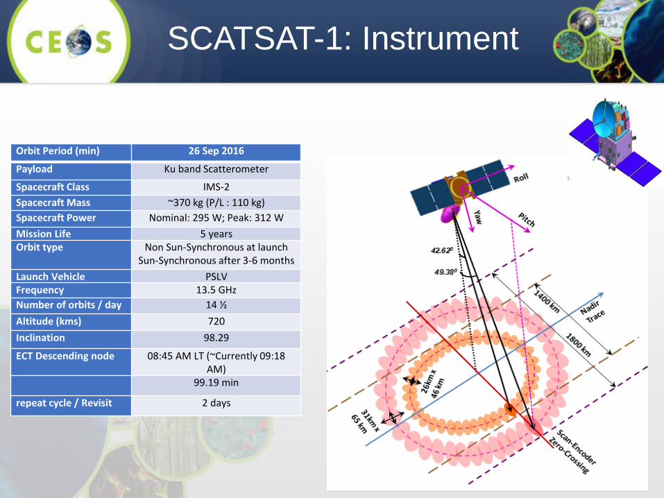
Orbit Period (min) 26 Sep 2016
Payload Ku band Scatterometer
Spacecraft Class IMS-2
Spacecraft Mass ~370 kg (P/L : 110 kg)
Spacecraft Power Nominal: 295 W; Peak: 312 W
Mission Life 5 yearsOrbit type Non Sun-Synchronous at launch
Sun-Synchronous after 3-6 months
Launch Vehicle PSLVFrequency 13.5 GHz
Number of orbits / day 14 ½
Altitude (kms) 720
Inclination 98.29
ECT Descending node 08:45 AM LT (~Currently 09:18 AM)
99.19 min
repeat cycle / Revisit 2 days
SCATSAT-1: Instrument
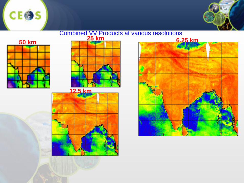
Combined VV Products at various resolutions
50 km
12.5 km
25 km 6.25 km
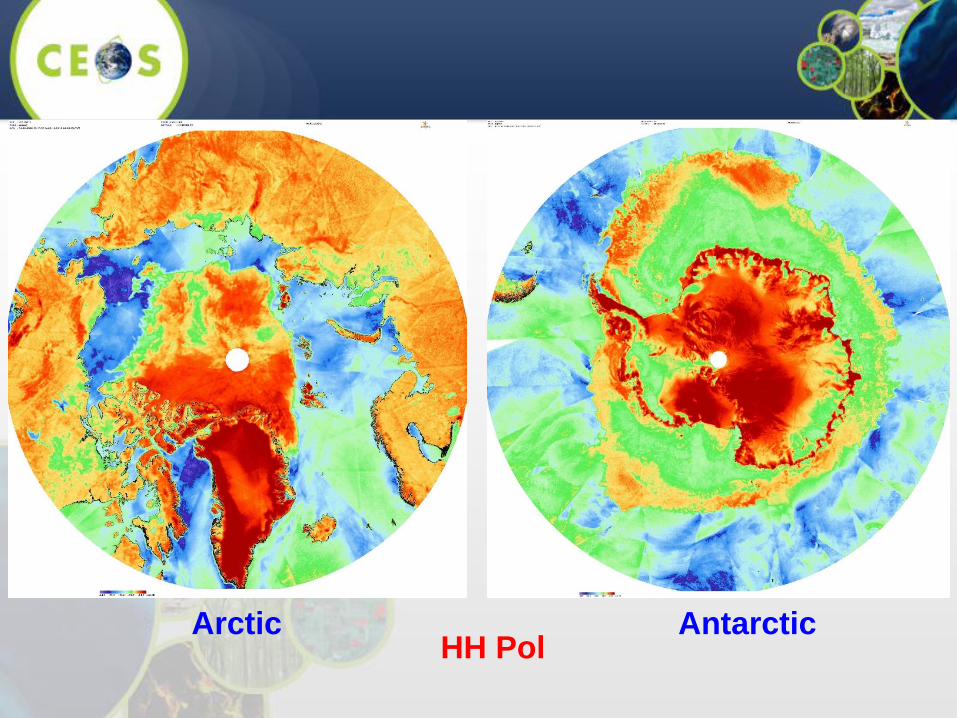
HH PolArctic Antarctic

50 Km Resolution25 Km Resolution12.5 Km Resolution6.25 Km Resolution2.25 Km Resolution

12
Hurricane Matthew, Near US Coast as
observed by Scatsat-1, 1450 GMT Oct 05, 2016Hurricane Chaba, Near
South Korea Coast
(Scatsat-1: October 03,
2016 12.35 GMT
Scatsat-1 Products

13
TC Formation:
25 OCT 00 Z
Cyclogenesis
Prediction:
19 OCT 03 Z
Lead Prediction
time: 140 Hrs
Tropical Cyclogenesis of Tropical
cyclone KYANT (Bay of Bengal)

INSAT 3DR Meteorological Sensor Package
Sounder Imager
0.5 1.0 1.5 2.0Weighting Function
2
3
4
5
6789
2
3
4
5
6789
10
100
1000
Ch6 (12.66mic)
Ch7 (12.02mic)
Ch8 (11.03mic)
Ch9 (9.71mic)
Ch10 (7.43mic)
Ch11 (7.02mic)
Ch12 (6.51mic)
INSAT-3D Weighting Function over Indian Region (July)
0.0 0.3 0.5 0.8 1.0Weighting Function
2
3
4
5
6789
2
3
4
5
6789
10
100
1000
Ch1 (14.71mic)
Ch2 (14.37mic)
Ch3 (14.06mic)
Ch4 (13.64mic)
Ch5 (13.37mic)
0.00 0.25 0.50 0.75Weighting Function
2
3
4
5
6789
2
3
4
5
6789
10
100
1000
Ch13 (4.57mic)
Ch14 (4.52mic)
Ch15 (4.45mic)
Ch16 (4.13mic)
Ch17 (3.98mic)
Ch18 (3.74mic)
INSAT-3D Weighting
function over Indian
Region (July)
19 channel Sounder Advanced 6-channel imager
Applications: Improved estimation of water vapour content, cloud, wind vector,
upper tropospheric humidity, sea surface temperature and surface insolation
Sensor Bands (m) Spatial Res.
Imager VIS (0.55-0.75), SWIR (1.55-1.70)
MIR (3.8-4.0)
WV (6.5-7.1)
TIR1 (10.2-11.3), TIR2(11.5-12.5)
1km x 1km
4km x 4km
8km x 8km
4km x 4km
Sounder 19 channels 10km x 10km

15INSAT-3D Winds are continuously being
assimilated in IMD/NCMRWF Models
Major Applications of INSAT-3DR
More accurate
Atmospheric
Winds from
INSAT-3D/3DR
Combination
Current status of
INSAT-3D winds
With respect to
Meteosat-7.
INSAT-winds are
likely to improve
further due to
INSAT-3DR
Heat-wave
monitoring &
prediction
Nowcasting
of extreme
weather
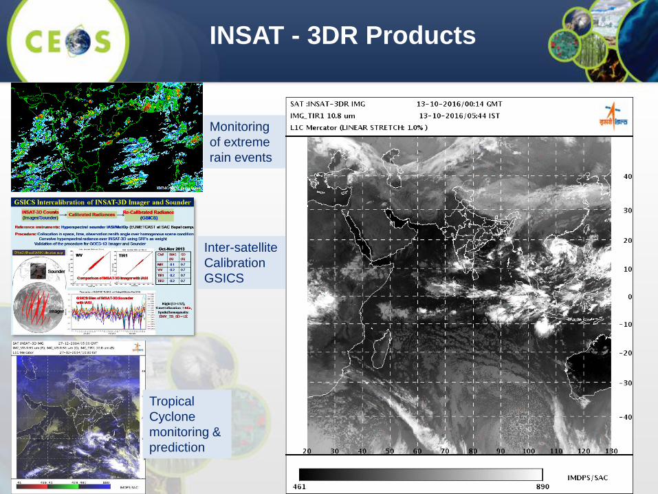
INSAT - 3DR Products
Monitoring
of extreme
rain events
Inter-satellite
Calibration
GSICS
Tropical
Cyclone
monitoring &
prediction
17
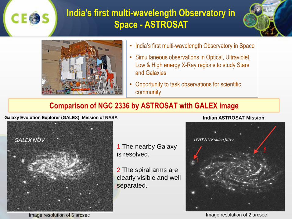
India’s first multi-wavelength Observatory in
Space - ASTROSAT
• India’s first multi-wavelength Observatory in Space
• Simultaneous observations in Optical, Ultraviolet,
Low & High energy X-Ray regions to study Stars
and Galaxies
• Opportunity to task observations for scientific
community
Comparison of NGC 2336 by ASTROSAT with GALEX image
Galaxy Evolution Explorer (GALEX) Mission of NASA
Image resolution of 6 arcsec Image resolution of 2 arcsec
Indian ASTROSAT Mission
1
21 The nearby Galaxy
is resolved.
2 The spiral arms are
clearly visible and well
separated.
18
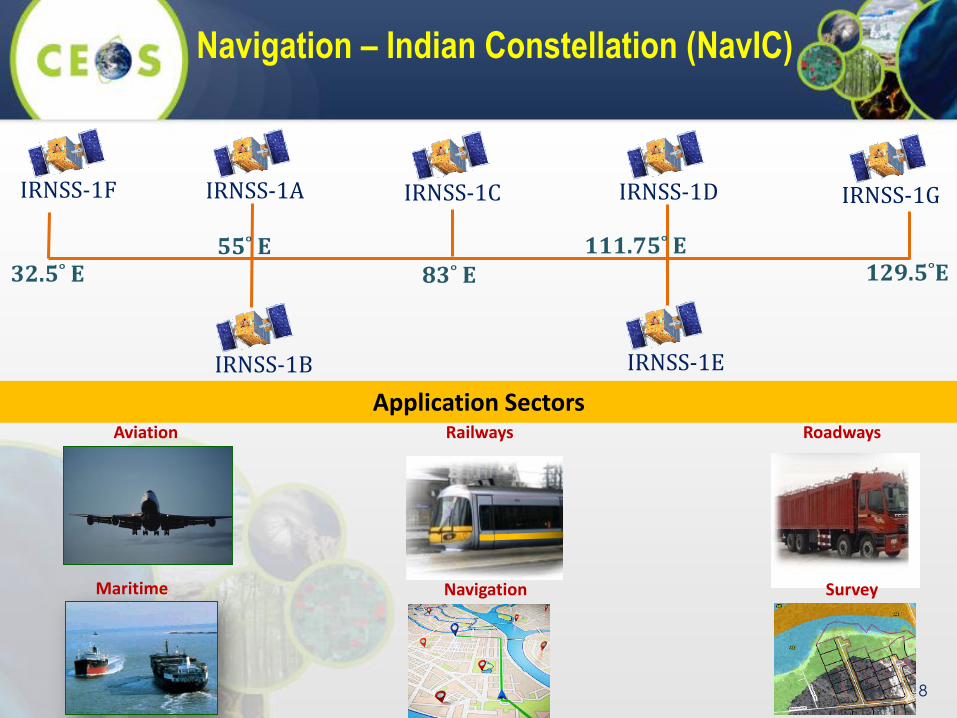
Navigation – Indian Constellation (NavIC)
32.5˚ E 129.5˚E
IRNSS-1F IRNSS-1G
55˚ E
IRNSS-1A
IRNSS-1B IRNSS-1E
IRNSS-1DIRNSS-1C
83˚ E111.75˚ E
Aviation
Maritime
Roadways
Application SectorsRailways
Navigation Survey

Decision Support Centre
MOSDACBhuvan
India-Water Resources Info. System Forest Fire Info. System
EO - Information Services
Vedas

BHUVAN Geoportal – A National
Geospatial Engine
• Visualisation
• Thematic Maps (WMS)
• Open Data (for download)
• User Data Site
• Crowdsourcing
2D, 3D, on mobile
Data Downloads
LISS_III, AWIFS,
CartoDSM (30m)
o Online Disaster Support
o Central/ State Ministries
o Crop Pest SurveillanceBhuvan Collaboration Portal
• Free Data download : > 200,000
• Daily data transfer : > 2.4 GB

RESOURCESAT-2A
• LISS 4 (5.8 m, 70 km swath, 10 bit)
• LISS 3 (23 m, 141 km swath, 10 bit)
• AWiFS (56 m, 800 km swath, 12 bit)
Continuity for Resourcesat-2
GISAT - 1
Geosynchronous Orbit
EO Missions - Near Future
• HR Mx VNIR : 50m; SWIR: 1.5 Km
• HYSI VNIR: 320m; WIR : 192m
CARTOSAT- 2D & 2E
• PAN (0.60 m, 10 km swath, 11 bit)
• Mx (2m , 10 km swath, 4 Xs, 11 bit)
VHR Panchromatic and
Multispectral Imaging
CARTOSAT-3VHR Panchromatic,
Multispectral Imaging
Orbit : 500 km
Local time: 0930 hrsOrbit : 817 km
Local time: 1030 hrs
Orbit : 450 km
Local time: 1030 hrs
• PAN (0.25 m, 16 km swath, 11 bit)
• Mx (1m , 16 km swath, 11 bit)
Orbit : 36000 km
Every 30 min
RISAT-1A
Continuity for RISAT-1
• C-Band SAR
Orbit : 536 km
Local time: 0600 hrs
NISAR
Joint Mission with JPL/NASA
Payloads• L & S Band SAR
Orbit : 747 km
Local time: 0600 hrs
Oceansat-3 & 3AContinuity for OS-2 with
Improvements
• 13 band OCM, IR-SST
• Ku-band Scatterometer ,
Orbit : 720 km
Local time: 1200 hrs
RESOURCESAT- 3 & 3A
Continuity for Resourcesat-2A
• ALISS-3:10m & 12m, 925 km, 5
Bands, ATCOR: 240m, 0.4-1m, ,
10 bit)
Orbit : 795 km
Local time: 1030 hrs
RS SAMPLER- 3S & 3SAHigh Res. Stereo imaging
PAN Fore & AFT
APAN: 1.25m, 60Km
Mx: 2.5m, 60Km, 4 Bands
Orbit : 630 km
Local time: 1030 hrs

THANK YOU