Arctic MArine GeophysicAl cAMpAiGn
70
I.I. 3180 ISTITUTO IDROGRAFICO DELLA MARINA GENOVA 2017 ARCTIC MARINE GEOPHYSICAL CAMPAIGN R. Ivaldi, M. Demarte and HIGH NORTH 17 Team HIGH NORTH 17 CRUISE REPORT
Transcript of Arctic MArine GeophysicAl cAMpAiGn
I.I. 3180
ISTITUTO IDROGRAFICO DELLA MARINA
GENOVA 2017
Arctic MArineGeophysicAl cAMpAiGn
R. Ivaldi, M. Demarte and HIGH NORTH 17 Team
hiGh north 17crUise report

I.I. 3180
ISTITUTO IDROGRAFICO DELLA MARINA
GENOVA 2017
HIGH NORTH 17CRUISE REPORTARCTIC MARINE
GEOPHySICAl CAMPAIGN
R. Ivaldi, M. Demarte and HIGH NORTH 17 Team
R. Ivaldi, M. Demarte and HIGH NORTH 17 Team
© Copyright, I.I.M. Genova 2017Istituto Idrografico della MarinaPasso Osservatorio, 4 - Tel. 010 24431 Telefax: 010 261400PEC: [email protected]: [email protected]: www.marina.difesa.it
“Questo documento contiene dati protetti da Copyright. Qualsiasi riproduzione o adattamento in qualsiasi forma, anche parziale, ivi comprese elaborazioni numeriche o fotocopie, è vietata senza una preventiva autorizzazione scritta da parte dell’Istituto Idrografico della Marina.”
Stampato dall’Istituto Idrografico della Marina – Agosto 2017
Introduzione
L’interesse della Marina Militare e dell’Istituto Idrografico per l’Artico nasce con un primo studio su un argomento quale quello della recente dinamica della copertura glaciale artica in relazione allo sviluppo di nuove rotte di navigazione.
I cambiamenti climatici e l’ambiente sono un argomento di grande sensibilità per la comunità internazionale a diversi livelli e le aree polari e, in particolare, l’Artico, risultano dei laboratori speciali per sviluppare e far crescere la conoscenza.
La campagna di Geofisica marina High North 17 è nata da una coincidenza di tanti fattori, in primis, il coinvolgimento sempre più crescente dell’Italia in Artico, seguito dall’entrata in linea di una nave oceanografica in grado di operare ai poli, Nave Alliance e, in ultimo, la presenza di personale alle mie dipendenze capace di trasformare questi ingredienti dalle grandi aspettative.
E’ bastato coinvolgere alcuni dei principali centri nazionali impegnati nella ricerca marina in Artico (CNR, ENEA, OGS) ed il Centro NATO – CMRE ed ecco che tutti i presupposti per un ottimo risultato erano presenti. Vincente è stata la sinergia dei quattro Enti di Ricerca con il coordinamento scientifico e logistico delle attività, fin dalle prime fasi di pianificazione e poi fino alla realizzazione della campagna, da parte dell’Istituto Idrografico della Marina.
In conclusione a questa mia prefazione, appare doveroso riportare i riconoscimenti ricevuti dal mondo scientifico, accademico e politico norvegese in occasione della conferenza stampa tenutasi a Tromsø il 28 luglio 2017, a conclusione di tutte le attività di campo. Durante tale evento Magnùs Johannesson, Direttore del Segretariato dell’Arctic Council, si è congratulato con l’Italia per questa importante iniziativa esprimendo grande apprezzamento per l’operato ed i primi risultati ottenuti, evidenziando le grandi capacità sinergiche del Team, riportando i propri auspici per il ruolo dell’Italia in qualità di Paese osservatore attivo nell’Arctic Council, pronto a nuove missioni e collaborazioni con la comunità scientifica internazionale.
IL DIRETTORE Luigi SINAPI

High North 17 – Cruise Report
R/V Alliance A5345
5
High North 17 Marine Geophysical Campaign
9 – 29 July 2017
Italian Navy
IIM CNR ENEA OGS CMRE
Roberta Ivaldi, Maurizio Demarte, Salvatore Agosta, Marina Ampolo Rella, Aprile Mauro, Matteo Bazzaro, Manuel Bensi, Anna Maria Biavasco, Andrea Caburlotto, Marco Carlevaro, Alessandro Cassinis, Omar Colombo, Andrea Cova, Marco De Palmis, Domenico Favuzzi, Valiant Ferrero, Bartolomé Garau, Matteo Guideri, Leonardo Langone, Craig Lewis, Renata Giulia Lucchi, Paolo Mansutti, Mauro Marro, Nunzio Moschetto, Pierpaolo Soria and Paolo Sturlese.

High North 17 – Cruise Report
R/V Alliance A5345
6
High North 17 – Cruise Report
R/V Alliance A5345
7
SUMMARY
High North 17 Campaign was conducted onboard the Italian R/V Alliance (Reykjavik July 9, Tromso July 29, 2017) having the principal objective of investigating the marine geophysical and geological conditions (hydrographic, oceanographic and biogeochemical) in 5 different sites South of Spitsbergen Archipelago: Inbis Channel, Kveithola Trough, Hornsund Banken, Sorkapp Banken and SW Storfjorden Trough. We surveyed solar irradiance – the atmosphere –, the water column (such as temperature, salinity, oxygen radionuclides, and nitrate contents), the sea bottom, and sub-bottom. Sometimes at over 1000 m depth. High North 17 was an activity-packed campaign, characterized by 65 stations with a 641 Km2 area surveyed by MBES (multibeam echo sounder) in 10 days – from July 16th to the 25th. The purpose was to map the particular bottom morphology, seabed nature, water physical characteristics, using CTD and water sampling, sediment sampling, irradiance measuring, and to confirm the possible existence of high density water currents in the area. A total of 43 CTD casts (108 water samples), 3 glider oceanographic missions, 12 box cores, 4 grabs and 2 gravity cores (64 sub cores, and 285 individual sediment subsamples), 10 irradiance measurements, 10 days of radiance measurements, 4 GoPro casts, were carried out during the HN17 cruise. In addition, according to the project work program, during MBES activity, 20 hours were dedicated to the maintenance/recovery of one yearly mooring that was deployed west of Spitsbergen (mooring S1). A new high resolution seabed mapping was obtained for all 5 sites according to hydrographic IHO standards.
The main results were obtained in the Inbis Channel area, where highly detailed morphological and sedimentological data were gathered. It is a very particular area, with glacial scars on the shelf, typical gullies and a canyon system originated by melt water erosion along the slope.
Another important goal was the collection of evidence of NSDW (Norwegian Sea Deep Water) and BSW (Brine-enriched Shelf Waters) during the CTD surveys south of Spitsbergen. The data collected along two transects will help us to define the thermohaline properties of the BSW formed during winter in the Storfjorden through ice formation (large heat loss in its polynya), and trapped in the major pits. A preliminary hypothesis was that through our survey we detected the quick and pulsating passage of very cold and salty (θ<0°C, S>35) bottom waters, associable to the BSW properties described in literature. We are confident that by merging CTD cast, time-series at the S1 mooring, biogeochemical results from water samples, and high resolution bathymetry data we will be able to investigate the timing and possible pathways of the BSW and AW (Atlantic Water) in the southern part of the Spitsbergen Archipelago.
These preliminary results are an important starting point for our developing research over this area and for future collaborations.
Nave Alliance, Tromsø July 29th 2017
Chief Scientist Project Manager
Prof. Roberta IVALDI CDR Maurizio DEMARTE
High North 17 – Cruise Report
R/V Alliance A5345
8
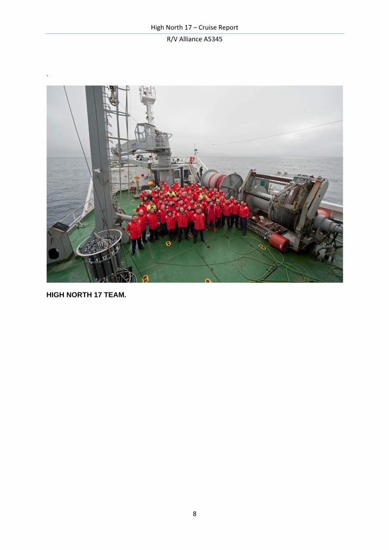
.
HIGH NORTH 17 TEAM.
High North 17 – Cruise Report
R/V Alliance A5345
9
CONTENTS PAG.
1. Scientific Background and Goals 10
2. Cruise Narrative 11
3. Operations and Preliminary Results 13
3.1 Water Column 13
3.1.1 CTD-Profiling and Rosette 13
3.1.2 Water column sampling and on-board analyses 17
3.2 Acoustic Doppler Current Profiler 21
3.3 Scanfish 21
3.4 Glider 23
3.5 Irradiance 25
3.6 Acoustic Survey 27
3.7 Seafloor sediment 30
3.8 Mooring maintenance 35
3.9 Public Information 38
4. References 39
5. Station List 40
6. Participants 42
Acknowledgements 43
High North 17 – Cruise Report
R/V Alliance A5345
10
1. Scientific Background and Goals
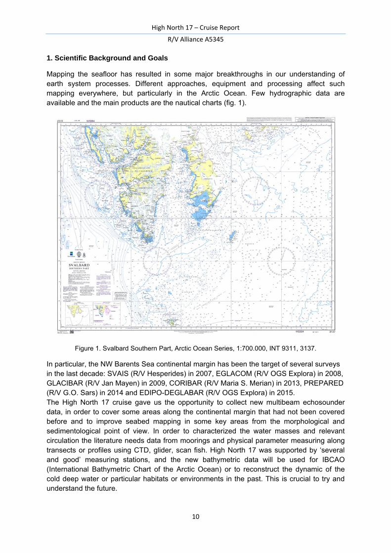
Mapping the seafloor has resulted in some major breakthroughs in our understanding of earth system processes. Different approaches, equipment and processing affect such mapping everywhere, but particularly in the Arctic Ocean. Few hydrographic data are available and the main products are the nautical charts (fig. 1).
Figure 1. Svalbard Southern Part, Arctic Ocean Series, 1:700.000, INT 9311, 3137.
In particular, the NW Barents Sea continental margin has been the target of several surveys in the last decade: SVAIS (R/V Hesperides) in 2007, EGLACOM (R/V OGS Explora) in 2008, GLACIBAR (R/V Jan Mayen) in 2009, CORIBAR (R/V Maria S. Merian) in 2013, PREPARED (R/V G.O. Sars) in 2014 and EDIPO-DEGLABAR (R/V OGS Explora) in 2015. The High North 17 cruise gave us the opportunity to collect new multibeam echosounder data, in order to cover some areas along the continental margin that had not been covered before and to improve seabed mapping in some key areas from the morphological and sedimentological point of view. In order to characterized the water masses and relevant circulation the literature needs data from moorings and physical parameter measuring along transects or profiles using CTD, glider, scan fish. High North 17 was supported by ‘several and good’ measuring stations, and the new bathymetric data will be used for IBCAO (International Bathymetric Chart of the Arctic Ocean) or to reconstruct the dynamic of the cold deep water or particular habitats or environments in the past. This is crucial to try and understand the future.
High North 17 – Cruise Report
R/V Alliance A5345
11
2. Cruise Narrative
R/V Alliance left the port of Reykjavik (Iceland) in the night of July, 11th, 2017.
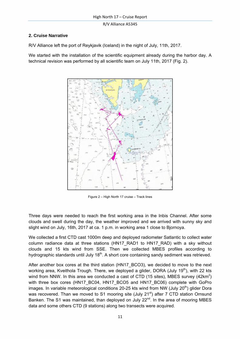
We started with the installation of the scientific equipment already during the harbor day. A technical revision was performed by all scientific team on July 11th, 2017 (Fig. 2).
Figure 2 – High North 17 cruise – Track lines
Three days were needed to reach the first working area in the Inbis Channel. After some clouds and swell during the day, the weather improved and we arrived with sunny sky and slight wind on July, 16th, 2017 at ca. 1 p.m. in working area 1 close to Bjornoya.
We collected a first CTD cast 1000m deep and deployed radiometer Satlantic to collect water column radiance data at three stations (HN17_RAD1 to HN17_RAD) with a sky without clouds and 15 kts wind from SSE. Then we collected MBES profiles according to hydrographic standards until July 18th. A short core containing sandy sediment was retrieved.
After another box cores at the third station (HN17_BCO3), we decided to move to the next working area, Kveithola Trough. There, we deployed a glider, DORA (July 19th), with 22 kts wind from NNW. In this area we conducted a cast of CTD (15 sites), MBES survey (42km2) with three box cores (HN17_BC04, HN17_BCO5 and HN17_BC06) complete with GoPro images. In variable meteorological conditions 20-25 kts wind from NW (July 20th) glider Dora was recovered. Than we moved to S1 mooring site (July 21st) after 7 CTD station Ornsund Banken. The S1 was maintained, than deployed on July 22nd. In the area of mooring MBES data and some others CTD (9 stations) along two transects were acquired.
High North 17 – Cruise Report
R/V Alliance A5345
12
We continued with cloudy sky our measurements of water column by CTD and deployed EIVA ScanfishIII® system to collect physical parameter along the same line of MBES (July 23th) in Sorkapp Banken (easternmost area, south Spitsbergen).
July 24th after MBES survey (149 km2) there was the deployment of a second glider, Laura, recording high resolution oceanographic data after 4 sediment samplings (HN17_BC07 and HN17_BC08, HN17_GCO01 and HN17_GCO02). At the end there was another deployment of glider Dora and two radiance measurements were recorded.
Than we moved to the last working area, Storfjorden Trough, in order to characterize the irradiance, water column physical parameters, bottom and sub bottom using MBES with different penetration and the acoustic backscatter data.
The last ping was acquired 75° 29’ 57.5“N and 014° 57’ 54.3”E, July 25th at 1850 GMT. The sky was cloudy with a 15 kts wind from W but the sea was calm. July 27th morning R/V Alliance arrived in Tromso.
High North 17 was a dream come true - Sognare ad occhi aperti e realizzare che è realtà chiudendoli.
High North 17 – Cruise Report
R/V Alliance A5345
13
3. Operations and Preliminary Results
3.1 Water Column
3.1.1 CTD-Profiling and Rosette (Bensi M., Guideri M., Ampolo Rella M., Mansutti P.)
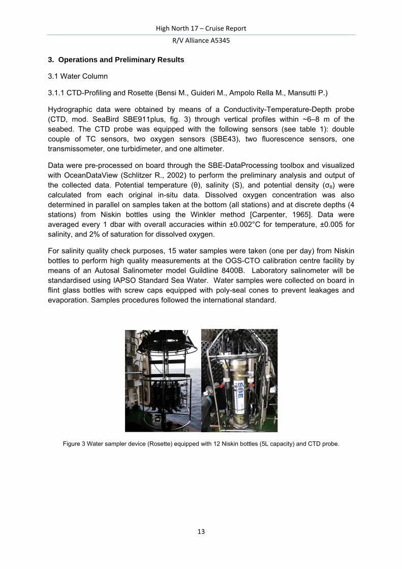
Hydrographic data were obtained by means of a Conductivity-Temperature-Depth probe (CTD, mod. SeaBird SBE911plus, fig. 3) through vertical profiles within ~6–8 m of the seabed. The CTD probe was equipped with the following sensors (see table 1): double couple of TC sensors, two oxygen sensors (SBE43), two fluorescence sensors, one transmissometer, one turbidimeter, and one altimeter.
Data were pre-processed on board through the SBE-DataProcessing toolbox and visualized with OceanDataView (Schlitzer R., 2002) to perform the preliminary analysis and output of the collected data. Potential temperature (θ), salinity (S), and potential density (σθ) were calculated from each original in-situ data. Dissolved oxygen concentration was also determined in parallel on samples taken at the bottom (all stations) and at discrete depths (4 stations) from Niskin bottles using the Winkler method [Carpenter, 1965]. Data were averaged every 1 dbar with overall accuracies within ±0.002°C for temperature, ±0.005 for salinity, and 2% of saturation for dissolved oxygen.
For salinity quality check purposes, 15 water samples were taken (one per day) from Niskin bottles to perform high quality measurements at the OGS-CTO calibration centre facility by means of an Autosal Salinometer model Guildline 8400B. Laboratory salinometer will be standardised using IAPSO Standard Sea Water. Water samples were collected on board in flint glass bottles with screw caps equipped with poly-seal cones to prevent leakages and evaporation. Samples procedures followed the international standard.
Figure 3 Water sampler device (Rosette) equipped with 12 Niskin bottles (5L capacity) and CTD probe.
High North 17 – Cruise Report
R/V Alliance A5345
14
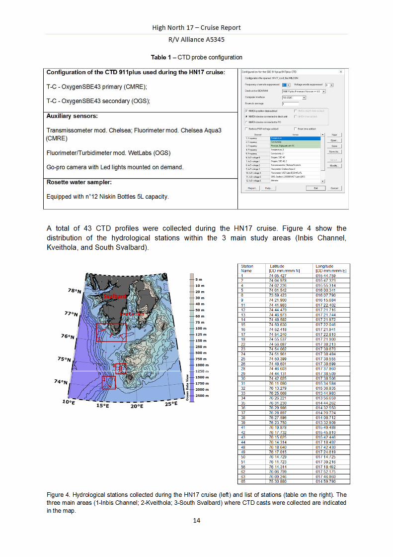
Table 1 – CTD probe configuration
Configuration of the CTD 911plus used during the HN17 cruise:
T-C - OxygenSBE43 primary (CMRE);
T-C - OxygenSBE43 secondary (OGS);
Auxiliary sensors:
Transmissometer mod. Chelsea; Fluorimeter mod. Chelsea Aqua3 (CMRE)
Fluorimeter/Turbidimeter mod. WetLabs (OGS)
Go-pro camera with Led lights mounted on demand.
Rosette water sampler:
Equipped with n°12 Niskin Bottles 5L capacity.
A total of 43 CTD profiles were collected during the HN17 cruise. Figure 4 show the distribution of the hydrological stations within the 3 main study areas (Inbis Channel, Kveithola, and South Svalbard).
Figure 4. Hydrological stations collected during the HN17 cruise (left) and list of stations (table on the right). The three main areas (1-Inbis Channel; 2-Kveithola; 3-South Svalbard) where CTD casts were collected are indicated in the map.
High North 17 – Cruise Report
R/V Alliance A5345
15
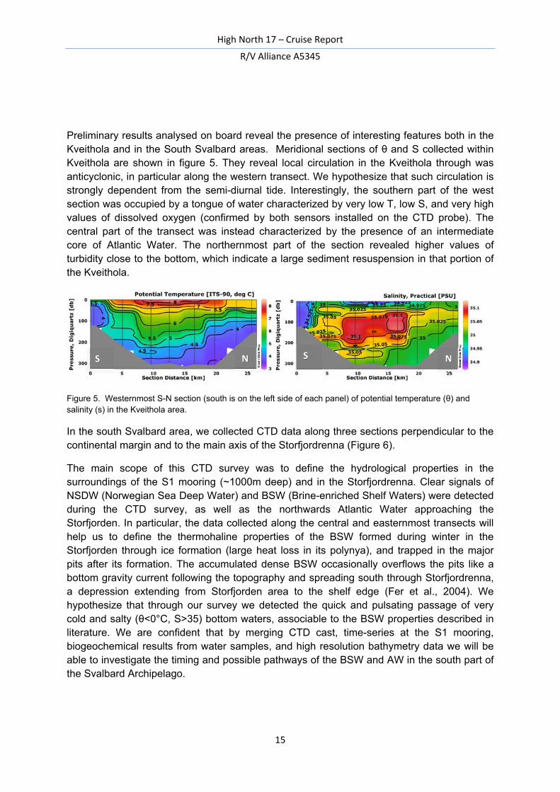
Preliminary results analysed on board reveal the presence of interesting features both in the Kveithola and in the South Svalbard areas. Meridional sections of θ and S collected within Kveithola are shown in figure 5. They reveal local circulation in the Kveithola through was anticyclonic, in particular along the western transect. We hypothesize that such circulation is strongly dependent from the semi-diurnal tide. Interestingly, the southern part of the west section was occupied by a tongue of water characterized by very low T, low S, and very high values of dissolved oxygen (confirmed by both sensors installed on the CTD probe). The central part of the transect was instead characterized by the presence of an intermediate core of Atlantic Water. The northernmost part of the section revealed higher values of turbidity close to the bottom, which indicate a large sediment resuspension in that portion of the Kveithola.
Figure 5. Westernmost S-N section (south is on the left side of each panel) of potential temperature (θ) and salinity (s) in the Kveithola area.
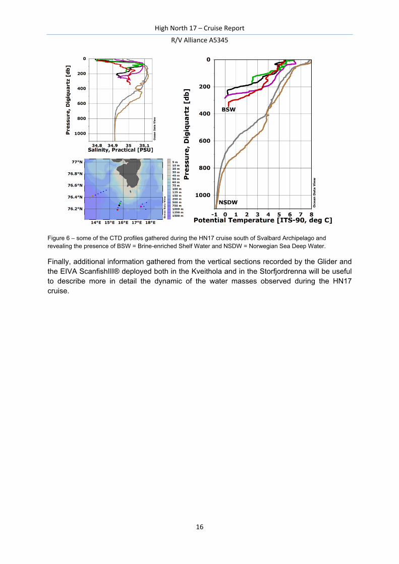
In the south Svalbard area, we collected CTD data along three sections perpendicular to the continental margin and to the main axis of the Storfjordrenna (Figure 6).
The main scope of this CTD survey was to define the hydrological properties in the surroundings of the S1 mooring (~1000m deep) and in the Storfjordrenna. Clear signals of NSDW (Norwegian Sea Deep Water) and BSW (Brine-enriched Shelf Waters) were detected during the CTD survey, as well as the northwards Atlantic Water approaching the Storfjorden. In particular, the data collected along the central and easternmost transects will help us to define the thermohaline properties of the BSW formed during winter in the Storfjorden through ice formation (large heat loss in its polynya), and trapped in the major pits after its formation. The accumulated dense BSW occasionally overflows the pits like a bottom gravity current following the topography and spreading south through Storfjordrenna, a depression extending from Storfjorden area to the shelf edge (Fer et al., 2004). We hypothesize that through our survey we detected the quick and pulsating passage of very cold and salty (θ<0°C, S>35) bottom waters, associable to the BSW properties described in literature. We are confident that by merging CTD cast, time-series at the S1 mooring, biogeochemical results from water samples, and high resolution bathymetry data we will be able to investigate the timing and possible pathways of the BSW and AW in the south part of the Svalbard Archipelago.
S N S N
High North 17 – Cruise Report
R/V Alliance A5345
16
Figure 6 – some of the CTD profiles gathered during the HN17 cruise south of Svalbard Archipelago and revealing the presence of BSW = Brine-enriched Shelf Water and NSDW = Norwegian Sea Deep Water.
Finally, additional information gathered from the vertical sections recorded by the Glider and the EIVA ScanfishIII® deployed both in the Kveithola and in the Storfjordrenna will be useful to describe more in detail the dynamic of the water masses observed during the HN17 cruise.
High North 17 – Cruise Report
R/V Alliance A5345
17
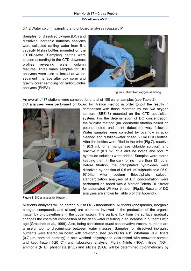
3.1.2 Water column sampling and onboard analyses (Bazzaro M.)
Samples for dissolved oxygen (DO) and dissolved inorganic nutrients analyses were collected spilling water from 5 L capacity Niskin bottles mounted on the CTD/Rosette. Sampling depths were chosen according to the CTD downcast profiles revealing water column features. Three times samples for DO analyses were also collected at water-sediment interface after box corer and gravity corer sampling for radionuclides analyses (ENEA). Figure 7. Dissolved oxygen sampling.
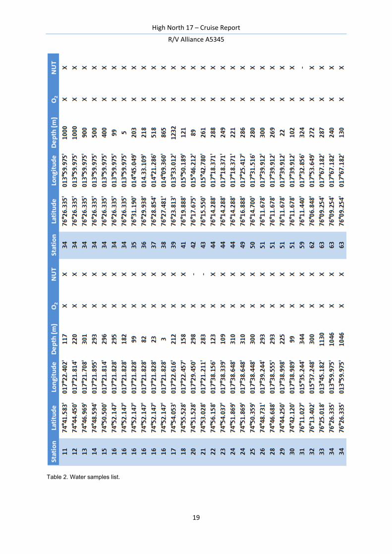
An overall of 37 stations were sampled for a total of 108 water samples (see Table 2). DO analyses were performed on board by titration method in order to put the results in
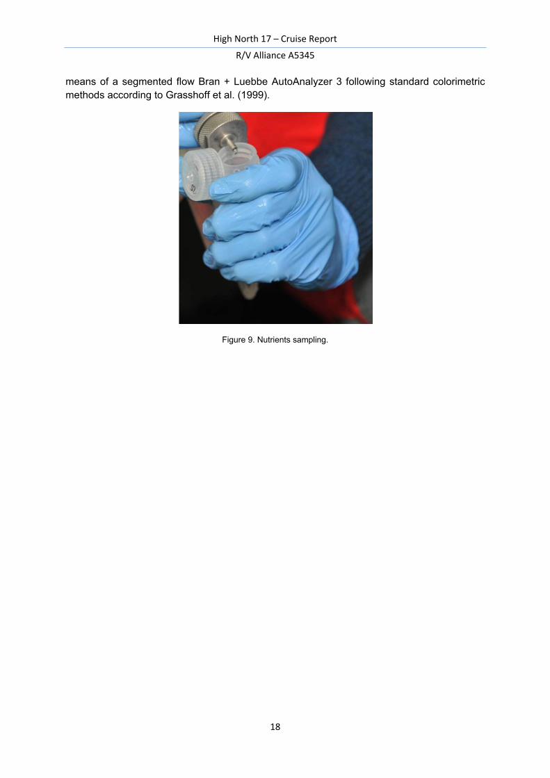
comparison with those recorded by the two oxygen sensors (SBE43) mounted on the CTD acquisition system. For the determination of DO concentration, the Winkler method (an iodometric titration based on potentiometric end point detection) was followed. Water samples were collected by overflow in acid-cleaned and distilled-water rinsed 60 ml BOD bottles. After the bottles were filled to the brim (Fig.7), reactive 1 (0.3 mL of a manganese chloride solution) and reactive 2 (0.3 mL of a alkaline iodide and sodium hydroxide solution) were added. Samples were stored keeping them in the dark for no more than 12 hours. Before titration, the precipitated hydroxides were dissolved by addition of 0.5 mL of sulphuric acid 95.0-97.0%. After sodium thiosulphate solution standardization analyses of DO concentration were performed on board with a Mettler Toledo DL titrator for automated Winkler titration (Fig.8). Results of DO analyses are shown In Table 3 of the Appendix.
Figure 8. DO analyses by filtration.
Nutrients analyses will be carried out at OGS laboratories. Nutrients (phosphorus, inorganic nitrogen compounds and silicon) are elements involved in the production of the organic matter by photosynthesis in the upper ocean. The particle flux from the surface gradually changes the chemical composition of the deep water resulting in an increase in nutrients with age (Grasshoff et al., 1999). Also, being considered quasi-conservative tracers, nutrients are a useful tool to discriminate between water masses. Samples for dissolved inorganic nutrients were filtered on board with pre-combusted (450°C for 4 h) Whatman GF/F filters (0.7 μm, nominal porosity) in acid washed polyethylene vials rinsed with seawater sample and kept frozen (-20 C°) until laboratory analysis (Fig.9). Nitrite (NO2), nitrate (NO3), ammonia (NH4), phosphate (PO4) and silicate (SiO4) will be determined colorimetrically by
High North 17 – Cruise Report
R/V Alliance A5345
18
means of a segmented flow Bran + Luebbe AutoAnalyzer 3 following standard colorimetric methods according to Grasshoff et al. (1999).
Figure 9. Nutrients sampling.
High North 17 – Cruise Report
R/V Alliance A5345
19
Table 2. Water samples list.
High North 17 – Cruise Report
R/V Alliance A5345
20
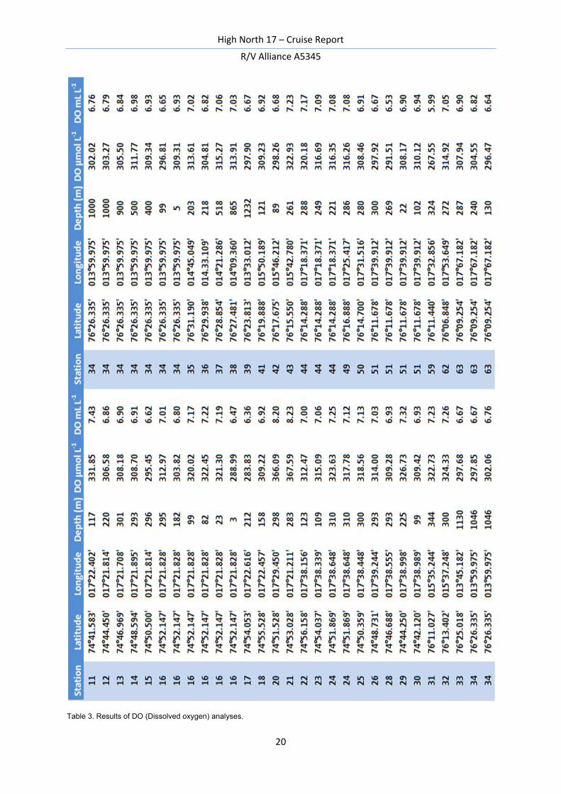
Table 3. Results of DO (Dissolved oxygen) analyses.
High North 17 – Cruise Report
R/V Alliance A5345
21
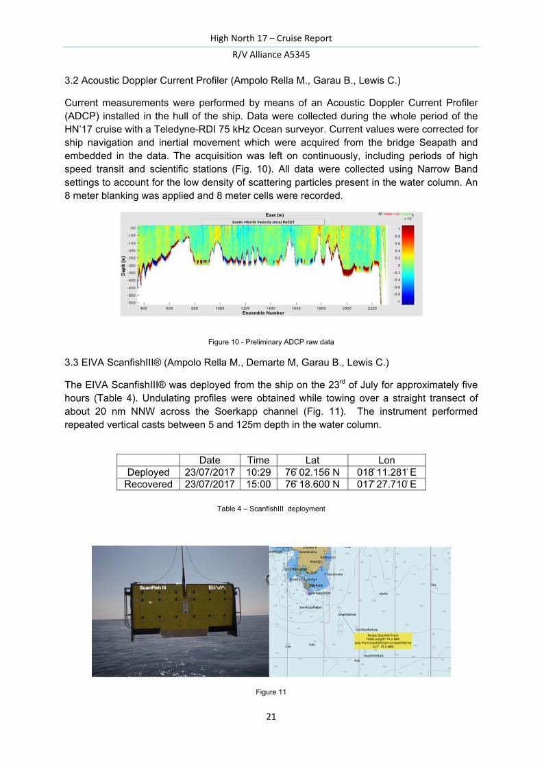
3.2 Acoustic Doppler Current Profiler (Ampolo Rella M., Garau B., Lewis C.)
Current measurements were performed by means of an Acoustic Doppler Current Profiler (ADCP) installed in the hull of the ship. Data were collected during the whole period of the HN’17 cruise with a Teledyne-RDI 75 kHz Ocean surveyor. Current values were corrected for ship navigation and inertial movement which were acquired from the bridge Seapath and embedded in the data. The acquisition was left on continuously, including periods of high speed transit and scientific stations (Fig. 10). All data were collected using Narrow Band settings to account for the low density of scattering particles present in the water column. An 8 meter blanking was applied and 8 meter cells were recorded.
Figure 10 - Preliminary ADCP raw data
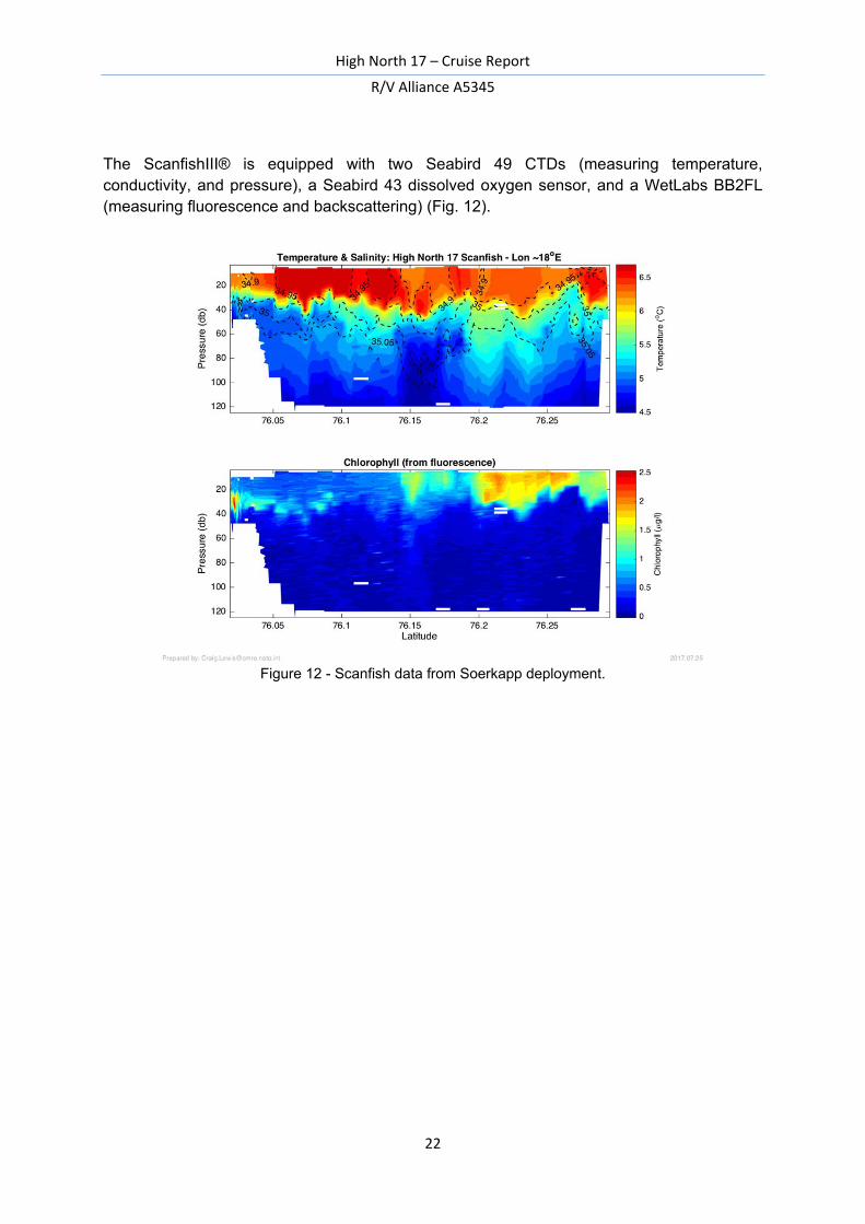
3.3 EIVA ScanfishIII® (Ampolo Rella M., Demarte M, Garau B., Lewis C.)
The EIVA ScanfishIII® was deployed from the ship on the 23rd of July for approximately five hours (Table 4). Undulating profiles were obtained while towing over a straight transect of about 20 nm NNW across the Soerkapp channel (Fig. 11). The instrument performed repeated vertical casts between 5 and 125m depth in the water column.
Table 4 – ScanfishIII deployment
Figure 11
Date Time Lat Lon Deployed 23/07/2017 10:29 76 ̊ 02.156 ̍ N 018 ̊ 11.281 ̍ E
Recovered 23/07/2017 15:00 76 ̊ 18.600 ̍ N 017 ̊ 27.710 ̍ E
High North 17 – Cruise Report
R/V Alliance A5345
22
The ScanfishIII® is equipped with two Seabird 49 CTDs (measuring temperature, conductivity, and pressure), a Seabird 43 dissolved oxygen sensor, and a WetLabs BB2FL (measuring fluorescence and backscattering) (Fig. 12).
Figure 12 - Scanfish data from Soerkapp deployment.
High North 17 – Cruise Report
R/V Alliance A5345
23
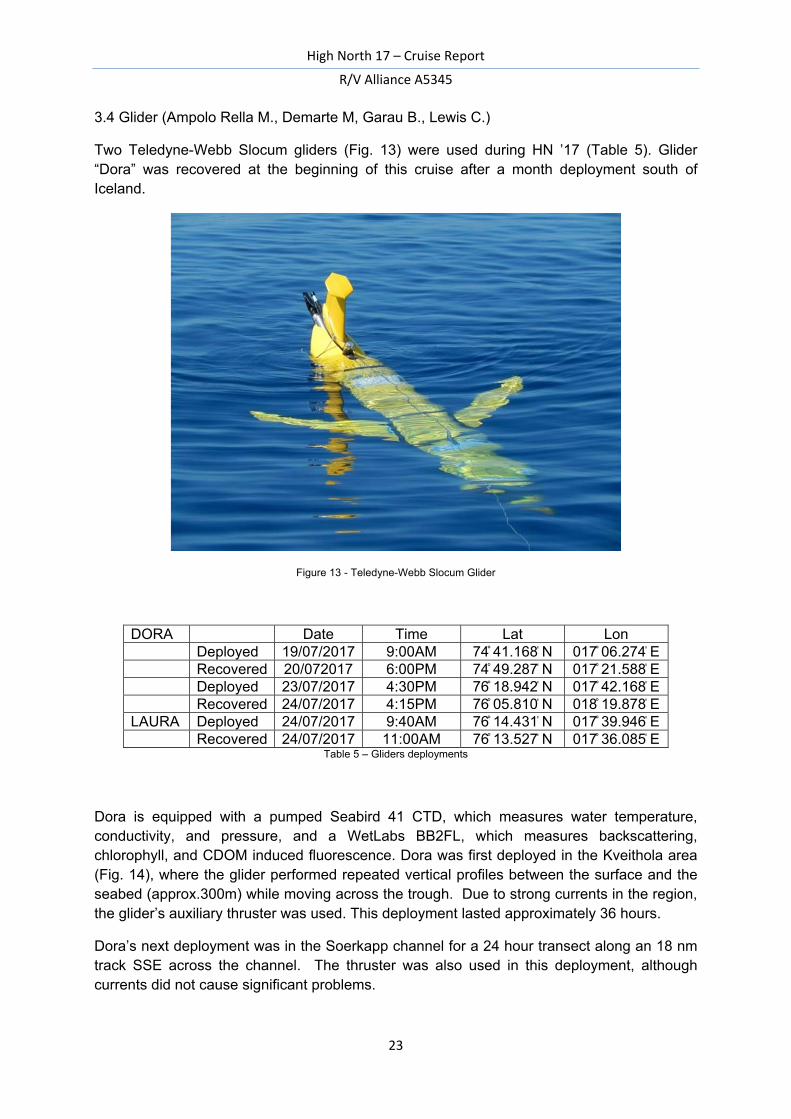
3.4 Glider (Ampolo Rella M., Demarte M, Garau B., Lewis C.)
Two Teledyne-Webb Slocum gliders (Fig. 13) were used during HN ’17 (Table 5). Glider “Dora” was recovered at the beginning of this cruise after a month deployment south of Iceland.
Figure 13 - Teledyne-Webb Slocum Glider
Table 5 – Gliders deployments
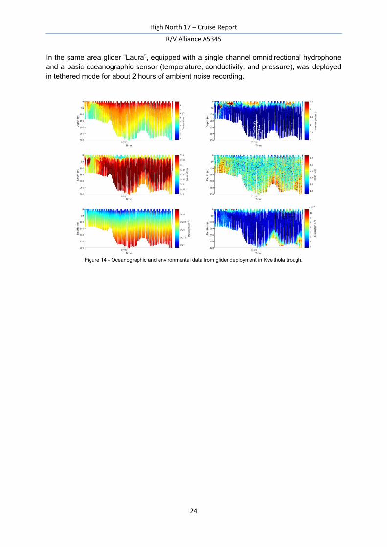
Dora is equipped with a pumped Seabird 41 CTD, which measures water temperature, conductivity, and pressure, and a WetLabs BB2FL, which measures backscattering, chlorophyll, and CDOM induced fluorescence. Dora was first deployed in the Kveithola area (Fig. 14), where the glider performed repeated vertical profiles between the surface and the seabed (approx.300m) while moving across the trough. Due to strong currents in the region, the glider’s auxiliary thruster was used. This deployment lasted approximately 36 hours.
Dora’s next deployment was in the Soerkapp channel for a 24 hour transect along an 18 nm track SSE across the channel. The thruster was also used in this deployment, although currents did not cause significant problems.
DORA Date Time Lat Lon Deployed 19/07/2017 9:00AM 74 ̊ 41.168 ̍ N 017 ̊ 06.274 ̍ E Recovered 20/072017 6:00PM 74 ̊ 49.287 ̍ N 017 ̊ 21.588 ̍ E Deployed 23/07/2017 4:30PM 76 ̊ 18.942 ̍ N 017 ̊ 42.168 ̍ E Recovered 24/07/2017 4:15PM 76 ̊ 05.810 ̍ N 018 ̊ 19.878 ̍ ELAURA Deployed 24/07/2017 9:40AM 76 ̊ 14.431 ̍ N 017 ̊ 39.946 ̍ E Recovered 24/07/2017 11:00AM 76 ̊ 13.527 ̍ N 017 ̊ 36.085 ̍ E
High North 17 – Cruise Report
R/V Alliance A5345
24
In the same area glider “Laura”, equipped with a single channel omnidirectional hydrophone and a basic oceanographic sensor (temperature, conductivity, and pressure), was deployed in tethered mode for about 2 hours of ambient noise recording.
Figure 14 - Oceanographic and environmental data from glider deployment in Kveithola trough.
High North 17 – Cruise Report
R/V Alliance A5345
25
3.5 Irradiance (L. Langone, P. Soria)
During the cruise High North 17, two different types of measurement of the solar irradiance were performed: a) in atmosphere (L. Langone); b) underwater radiance (P. Soria).
Irradiance in atmosphere
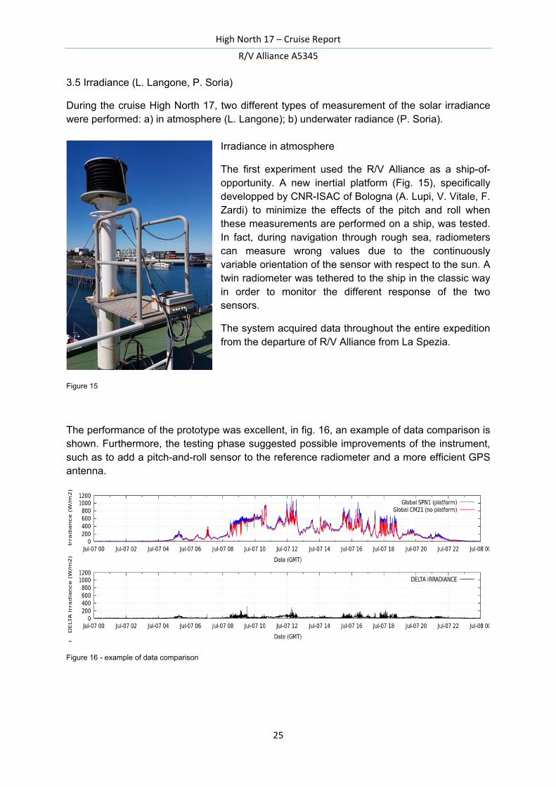
The first experiment used the R/V Alliance as a ship-of-opportunity. A new inertial platform (Fig. 15), specifically developped by CNR-ISAC of Bologna (A. Lupi, V. Vitale, F. Zardi) to minimize the effects of the pitch and roll when these measurements are performed on a ship, was tested. In fact, during navigation through rough sea, radiometers can measure wrong values due to the continuously variable orientation of the sensor with respect to the sun. A twin radiometer was tethered to the ship in the classic way in order to monitor the different response of the two sensors.
The system acquired data throughout the entire expedition from the departure of R/V Alliance from La Spezia.
Figure 15
The performance of the prototype was excellent, in fig. 16, an example of data comparison is shown. Furthermore, the testing phase suggested possible improvements of the instrument, such as to add a pitch-and-roll sensor to the reference radiometer and a more efficient GPS antenna.
Figure 16 - example of data comparison
High North 17 – Cruise Report
R/V Alliance A5345
26
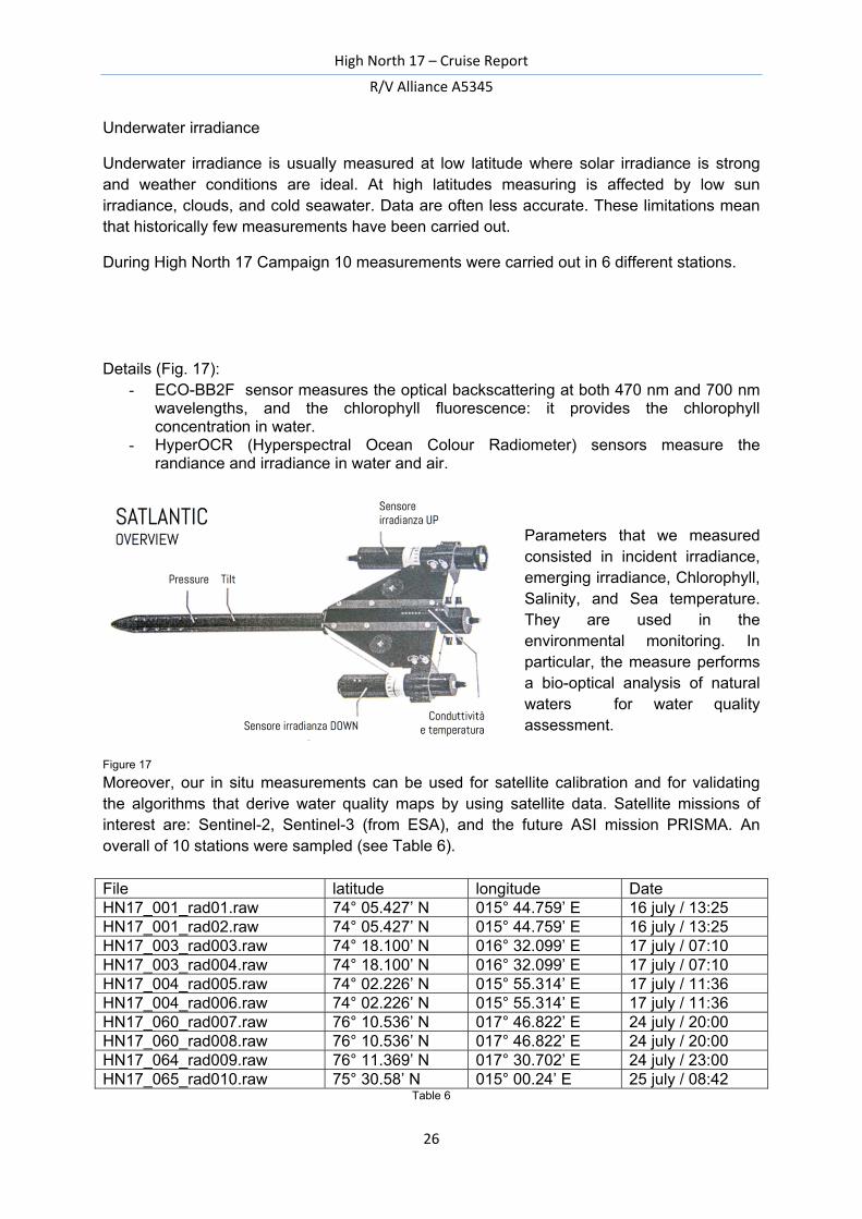
Underwater irradiance
Underwater irradiance is usually measured at low latitude where solar irradiance is strong and weather conditions are ideal. At high latitudes measuring is affected by low sun irradiance, clouds, and cold seawater. Data are often less accurate. These limitations mean that historically few measurements have been carried out.
During High North 17 Campaign 10 measurements were carried out in 6 different stations.
Details (Fig. 17): - ECO-BB2F sensor measures the optical backscattering at both 470 nm and 700 nm
wavelengths, and the chlorophyll fluorescence: it provides the chlorophyll concentration in water.
- HyperOCR (Hyperspectral Ocean Colour Radiometer) sensors measure the randiance and irradiance in water and air.
Parameters that we measured consisted in incident irradiance, emerging irradiance, Chlorophyll, Salinity, and Sea temperature. They are used in the environmental monitoring. In particular, the measure performs a bio-optical analysis of natural waters for water quality assessment.
Figure 17
Moreover, our in situ measurements can be used for satellite calibration and for validating the algorithms that derive water quality maps by using satellite data. Satellite missions of interest are: Sentinel-2, Sentinel-3 (from ESA), and the future ASI mission PRISMA. An overall of 10 stations were sampled (see Table 6). File latitude longitude Date HN17_001_rad01.raw 74° 05.427’ N 015° 44.759’ E 16 july / 13:25 HN17_001_rad02.raw 74° 05.427’ N 015° 44.759’ E 16 july / 13:25 HN17_003_rad003.raw 74° 18.100’ N 016° 32.099’ E 17 july / 07:10 HN17_003_rad004.raw 74° 18.100’ N 016° 32.099’ E 17 july / 07:10 HN17_004_rad005.raw 74° 02.226’ N 015° 55.314’ E 17 july / 11:36 HN17_004_rad006.raw 74° 02.226’ N 015° 55.314’ E 17 july / 11:36 HN17_060_rad007.raw 76° 10.536’ N 017° 46.822’ E 24 july / 20:00 HN17_060_rad008.raw 76° 10.536’ N 017° 46.822’ E 24 july / 20:00 HN17_064_rad009.raw 76° 11.369’ N 017° 30.702’ E 24 july / 23:00 HN17_065_rad010.raw 75° 30.58’ N 015° 00.24’ E 25 july / 08:42
Table 6
High North 17 – Cruise Report
R/V Alliance A5345
27
3.6 Acoustic survey (A. Caburlotto, A. Cova, M. Marro, Sturlese P., Demarte M.)
Objectives
The NW Barents Sea continental margin has been the target of several surveys in the last decade: SVAIS (R/V Hesperides) in 2007, EGLACOM (R/V OGS Explora) in 2008, GLACIBAR (R/V Jan Mayen) in 2009, CORIBAR (R/V Maria S. Merian) in 2013, PREPARED (R/V G.O. Sars) in 2014 and EDIPO-DEGLABAR (R/V OGS Explora) in 2015.
These cruises allowed the acquisition of a wealth of morphobathymetric data that are now jointly processed at OGS.
The High North17 cruise gave us the opportunity to collect new Multibeam data, in order to complete some areas along the continental margin that haven’t been completely covered previously as well as improve the morphobathymetric charts in some key areas.
This acoustic survey focused on three areas in particular:
I. The Inbis channel system, southwestern off Bear Island This channel area has a strategic importance in the understanding of glacial, oceanographic and sedimentological dynamics along this margin. The INBIS channel is a very peculiar structure in the Barents Sea; channel systems are in fact rare on the Northern Norwegian margin and confined to the INBIS and Lofoten Basin channels. The INBIS channel originates from a series of tributary canyons, converging in a trunk-type channel, leading to a deep sea lobe system. The INBIS channel is inferred to have been produced by turbidity flows, flowing from tributary canyons incising the upper part of the continental slope between Bear Island TMF and Kveithola TMF.
II. The northern part of the Storfjiorden trough, southern off Sorkap Banken The Storfjiorden is a conduit for the cold and dense water masses formed from brine-enriched shelf water flowing westward, south off Sorkapp Banken, toward the shelf edge. A detailed morphobathymetry of this area will help in define the flow paths of these dense water masses.
III. The continental shelf edge in the southern part of the Storfjiorden. Based on existing bathymetric and sub-bottom data collected in the previous CORIBAR cruise (2013), this portion of the continental shelf shows a thin layer of soft sediments overlying a coarser layer formed by glacigenic till. Due to these characteristics, the area has been chosen to run a pilot experiment: the objective is to evaluate the possibility to penetrate the superficial thin layer with the multibeam and the feasibility to make a 3D bathymetric model of the underlying coarser till layer.
Furthermore, 2 other areas have been investigated with the Multibeam as site surveys:
IV. The area where the S1 mooring (see chapter 3.7) has been deployed, in order to characterise the bathymetry as well as the seabed characteristics to define the better area for the mooring deployment:
V. A limited area in the Kveithola trough, to map some structures linked to the presence of authigenic carbonates and/or chemosynthetic communities on the seafloor sampled during the previous BURSTER cruise in 2016. The acoustic survey was used to locate the sediment sampling to investigate these communities from a sedimentological point of view (see chapter 3.6).
High North 17 – Cruise Report
R/V Alliance A5345
28
Acquisition
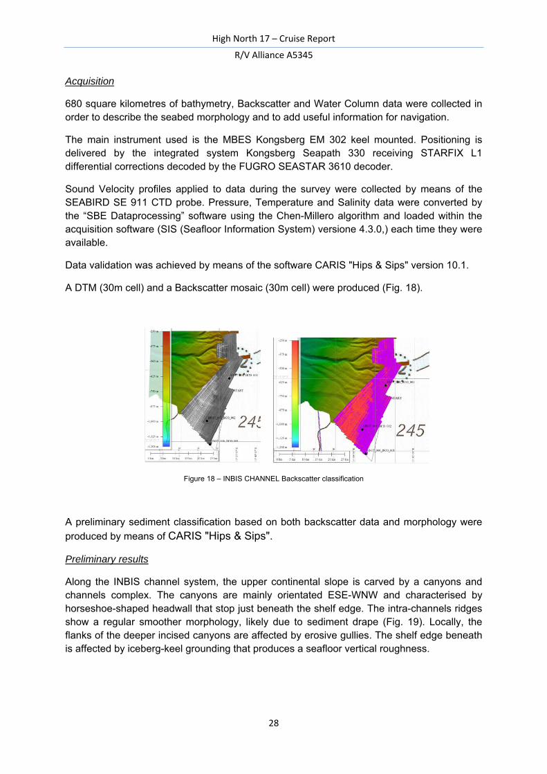
680 square kilometres of bathymetry, Backscatter and Water Column data were collected in order to describe the seabed morphology and to add useful information for navigation.
The main instrument used is the MBES Kongsberg EM 302 keel mounted. Positioning is delivered by the integrated system Kongsberg Seapath 330 receiving STARFIX L1 differential corrections decoded by the FUGRO SEASTAR 3610 decoder.
Sound Velocity profiles applied to data during the survey were collected by means of the SEABIRD SE 911 CTD probe. Pressure, Temperature and Salinity data were converted by the “SBE Dataprocessing” software using the Chen-Millero algorithm and loaded within the acquisition software (SIS (Seafloor Information System) versione 4.3.0,) each time they were available.
Data validation was achieved by means of the software CARIS "Hips & Sips" version 10.1.
A DTM (30m cell) and a Backscatter mosaic (30m cell) were produced (Fig. 18).
Figure 18 – INBIS CHANNEL Backscatter classification
A preliminary sediment classification based on both backscatter data and morphology were
produced by means of CARIS "Hips & Sips".
Preliminary results
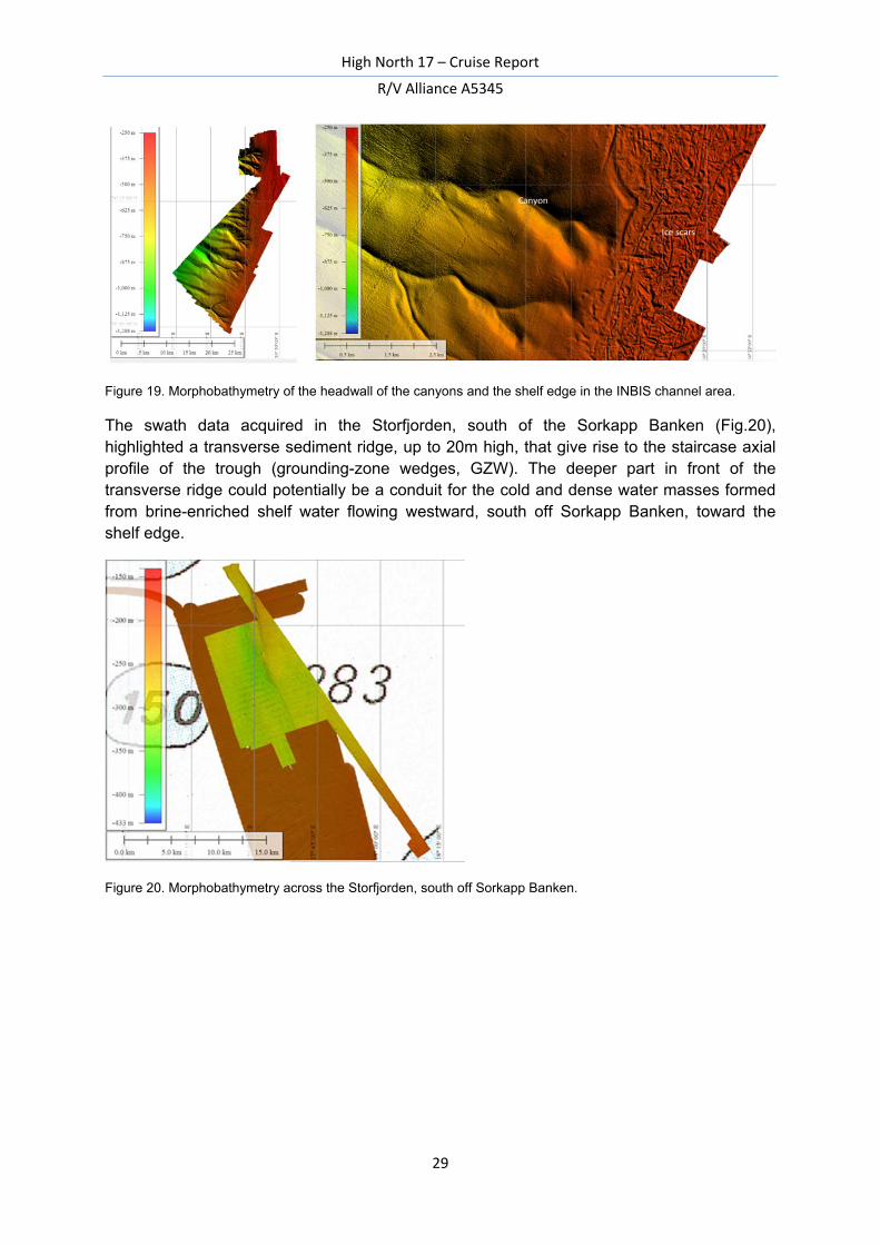
Along the INBIS channel system, the upper continental slope is carved by a canyons and channels complex. The canyons are mainly orientated ESE-WNW and characterised by horseshoe-shaped headwall that stop just beneath the shelf edge. The intra-channels ridges show a regular smoother morphology, likely due to sediment drape (Fig. 19). Locally, the flanks of the deeper incised canyons are affected by erosive gullies. The shelf edge beneath is affected by iceberg-keel grounding that produces a seafloor vertical roughness.
High North 17 – Cruise Report
R/V Alliance A5345
29
Figure 19. Morphobathymetry of the headwall of the canyons and the shelf edge in the INBIS channel area.
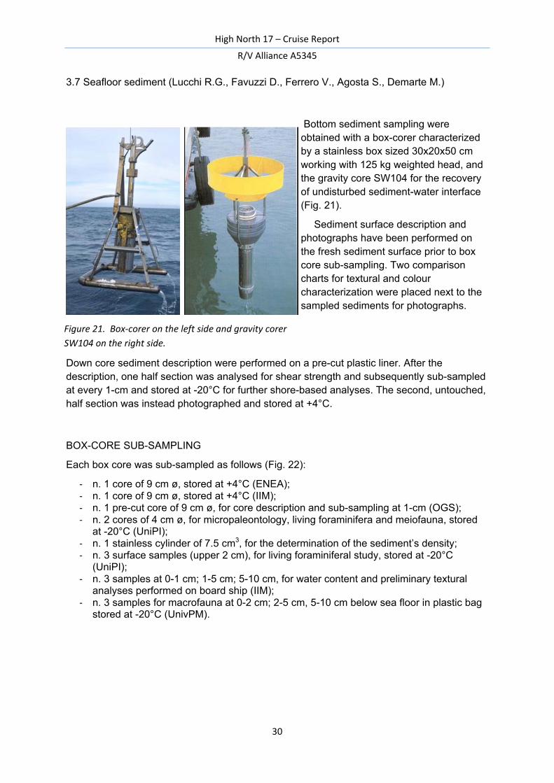
The swath data acquired in the Storfjorden, south of the Sorkapp Banken (Fig.20), highlighted a transverse sediment ridge, up to 20m high, that give rise to the staircase axial profile of the trough (grounding-zone wedges, GZW). The deeper part in front of the transverse ridge could potentially be a conduit for the cold and dense water masses formed from brine-enriched shelf water flowing westward, south off Sorkapp Banken, toward the shelf edge.
Figure 20. Morphobathymetry across the Storfjorden, south off Sorkapp Banken.
High North 17 – Cruise Report
R/V Alliance A5345
30
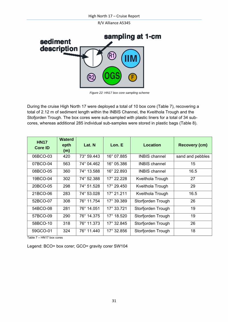
3.7 Seafloor sediment (Lucchi R.G., Favuzzi D., Ferrero V., Agosta S., Demarte M.)
Bottom sediment sampling were obtained with a box-corer characterized by a stainless box sized 30x20x50 cm working with 125 kg weighted head, and the gravity core SW104 for the recovery of undisturbed sediment-water interface (Fig. 21).
Sediment surface description and photographs have been performed on the fresh sediment surface prior to box core sub-sampling. Two comparison charts for textural and colour characterization were placed next to the sampled sediments for photographs.
Down core sediment description were performed on a pre-cut plastic liner. After the description, one half section was analysed for shear strength and subsequently sub-sampled at every 1-cm and stored at -20°C for further shore-based analyses. The second, untouched, half section was instead photographed and stored at +4°C.
BOX-CORE SUB-SAMPLING
Each box core was sub-sampled as follows (Fig. 22): - n. 1 core of 9 cm ø, stored at +4°C (ENEA); - n. 1 core of 9 cm ø, stored at +4°C (IIM); - n. 1 pre-cut core of 9 cm ø, for core description and sub-sampling at 1-cm (OGS); - n. 2 cores of 4 cm ø, for micropaleontology, living foraminifera and meiofauna, stored at -20°C (UniPI); - n. 1 stainless cylinder of 7.5 cm3, for the determination of the sediment’s density; - n. 3 surface samples (upper 2 cm), for living foraminiferal study, stored at -20°C (UniPI); - n. 3 samples at 0-1 cm; 1-5 cm; 5-10 cm, for water content and preliminary textural analyses performed on board ship (IIM); - n. 3 samples for macrofauna at 0-2 cm; 2-5 cm, 5-10 cm below sea floor in plastic bag stored at -20°C (UnivPM).
Figure 21. Box-corer on the left side and gravity corer SW104 on the right side.
High North 17 – Cruise Report
R/V Alliance A5345
31
Figure 22: HN17 box core sampling scheme
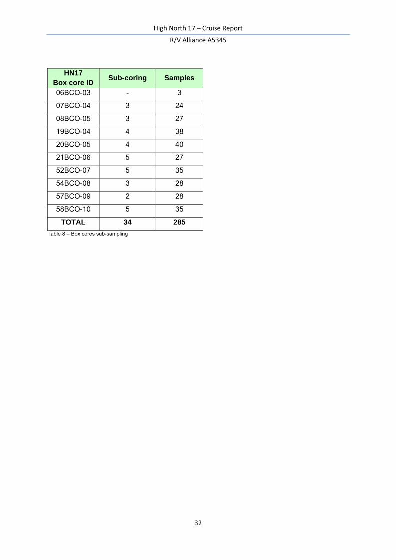
During the cruise High North 17 were deployed a total of 10 box core (Table 7), recovering a total of 2.12 m of sediment length within the INBIS Channel, the Kveithola Trough and the Stofjorden Trough. The box cores were sub-sampled with plastic liners for a total of 34 sub-cores, whereas additional 285 individual sub-samples were stored in plastic bags (Table 8).
HN17 Core ID
Waterdepth (m)
Lat. N Lon. E Location Recovery (cm)
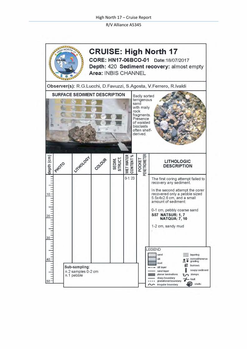
06BCO-03 420 73° 59.443 16° 07.885 INBIS channel sand and pebbles
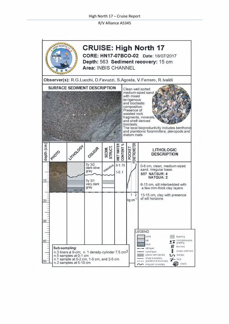
07BCO-04 563 74° 04.462 16° 05.386 INBIS channel 15
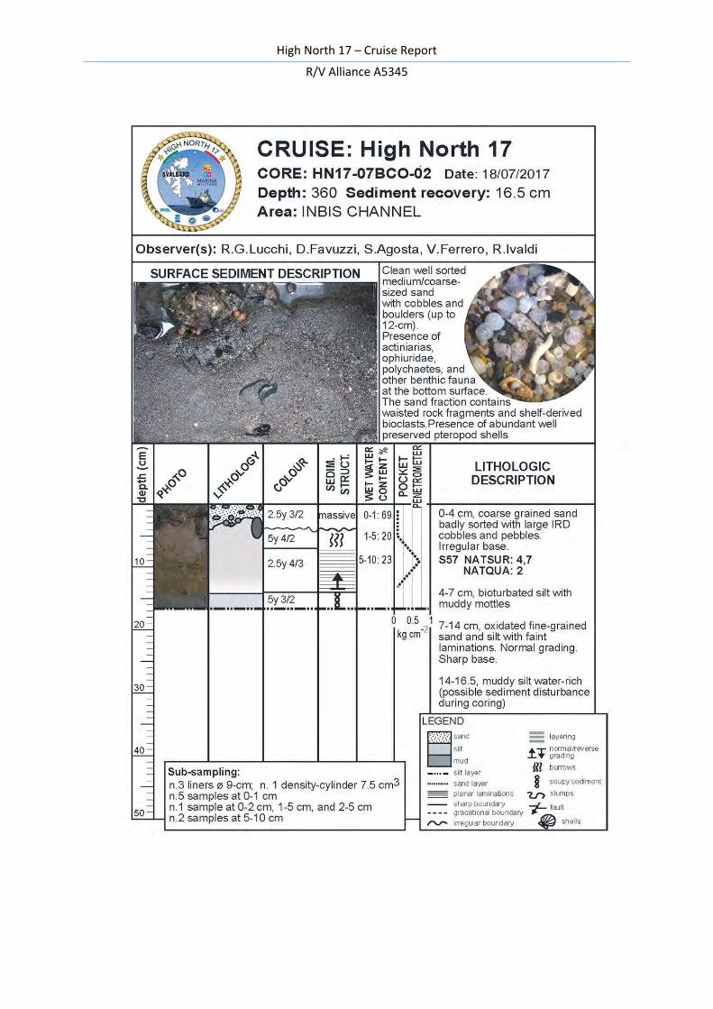
08BCO-05 360 74° 13.588 16° 22.893 INBIS channel 16.5
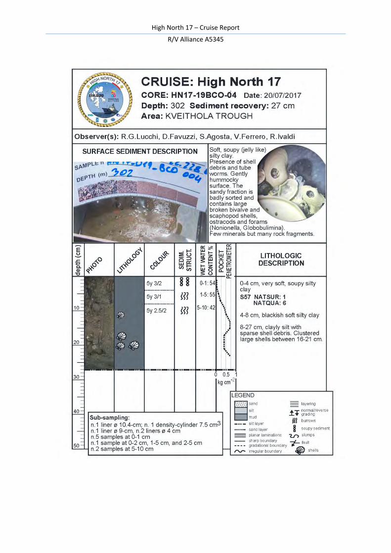
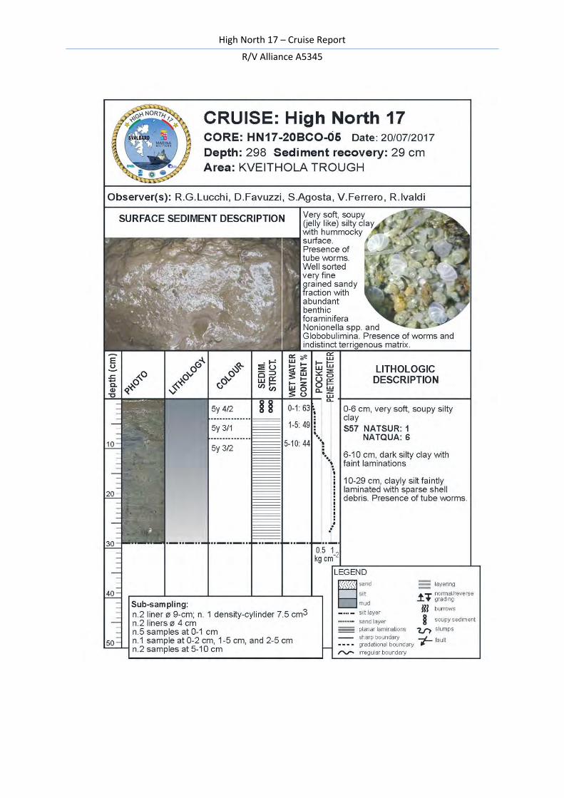
19BCO-04 302 74° 52.388 17° 22.228 Kveithola Trough 27
20BCO-05 298 74° 51.528 17° 29.450 Kveithola Trough 29
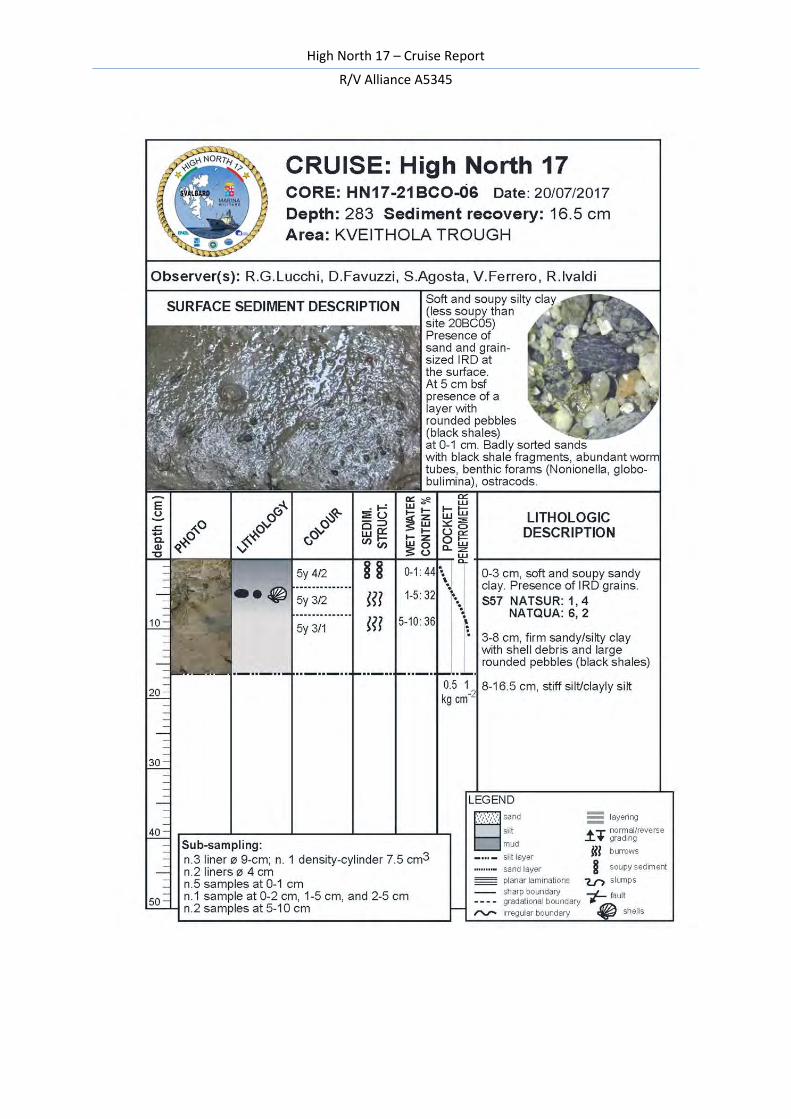
21BCO-06 283 74° 53.028 17° 21.211 Kveithola Trough 16.5
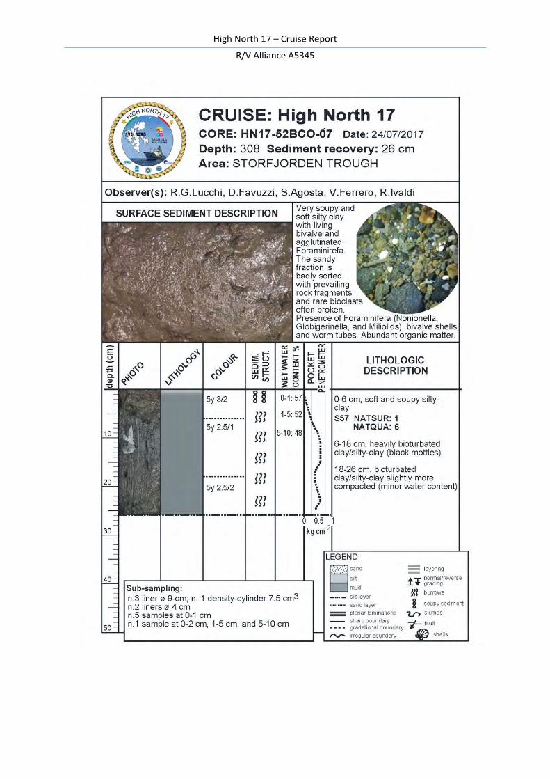
52BCO-07 308 76° 11.754 17° 39.389 Storfjorden Trough 26
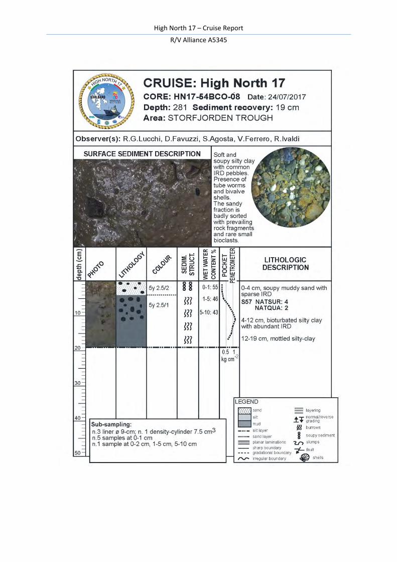
54BCO-08 281 76° 14.051 17° 33.721 Storfjorden Trough 19
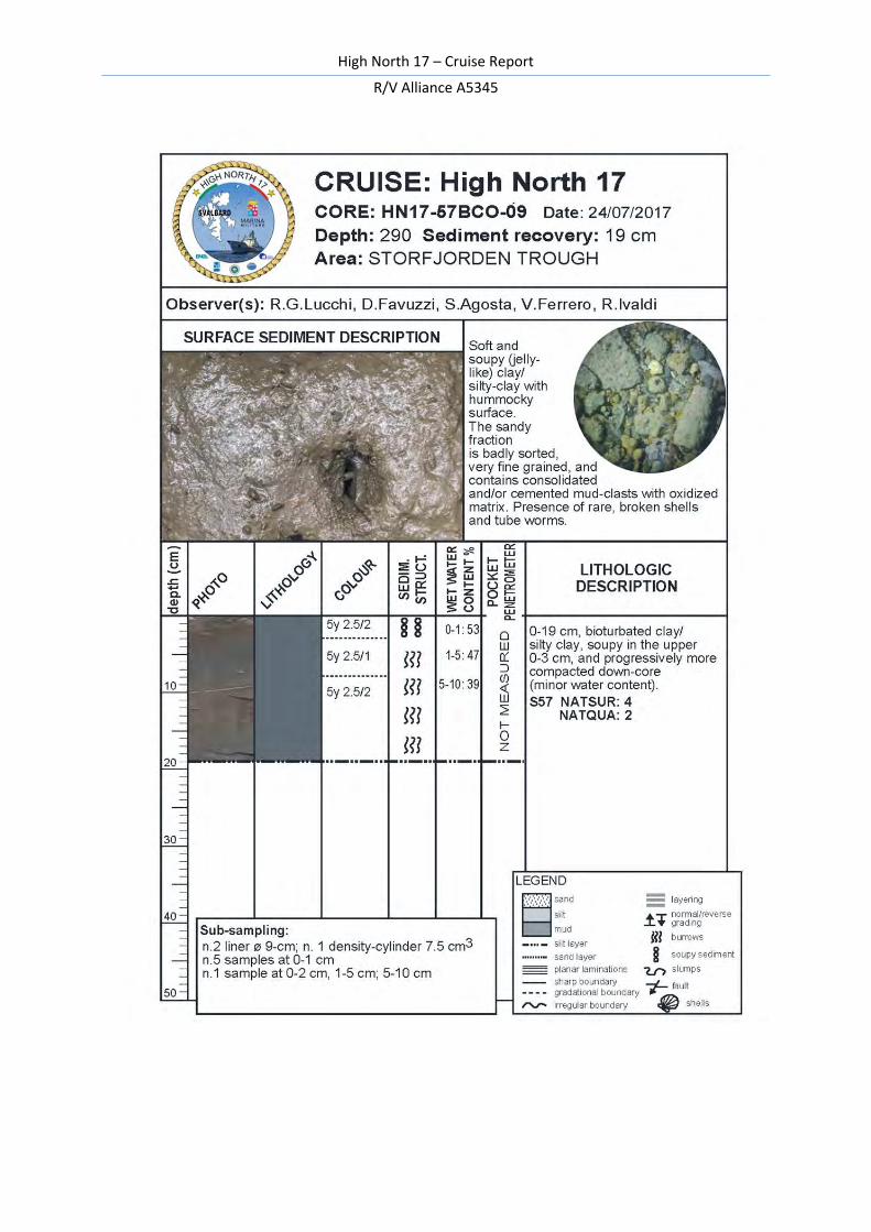
57BCO-09 290 76° 14.375 17° 18.520 Storfjorden Trough 19
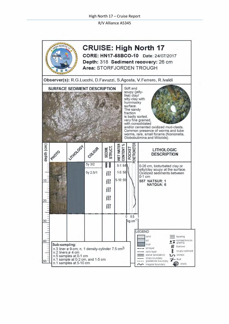
58BCO-10 318 76° 11.373 17° 32.845 Storfjorden Trough 26
59GCO-01 324 76° 11.440 17° 32.856 Storfjorden Trough 18
Table 7 – HN17 box cores
Legend: BCO= box corer; GCO= gravity corer SW104
High North 17 – Cruise Report
R/V Alliance A5345
32
HN17 Box core ID
Sub-coring Samples
06BCO-03 - 3
07BCO-04 3 24
08BCO-05 3 27
19BCO-04 4 38
20BCO-05 4 40
21BCO-06 5 27
52BCO-07 5 35
54BCO-08 3 28
57BCO-09 2 28
58BCO-10 5 35
TOTAL 34 285
Table 8 – Box cores sub-sampling

High North 17 – Cruise Report
R/V Alliance A5345
33
ON BOARD SEDIMENT ANALYSES
On board sediment analyses included the measurement of the shear strength by means of a pocket penetrometer (Tab. 9), and the determination of sediment bulk density, water content, and mud/sand ratio.
Table 9 – Pocket penetrometer
High North 17 – Cruise Report
R/V Alliance A5345
34
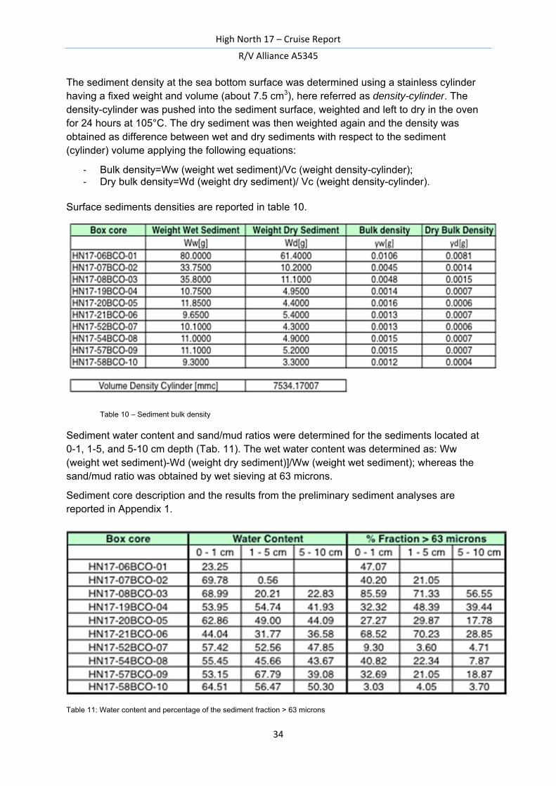
The sediment density at the sea bottom surface was determined using a stainless cylinder having a fixed weight and volume (about 7.5 cm3), here referred as density-cylinder. The density-cylinder was pushed into the sediment surface, weighted and left to dry in the oven for 24 hours at 105°C. The dry sediment was then weighted again and the density was obtained as difference between wet and dry sediments with respect to the sediment (cylinder) volume applying the following equations: - Bulk density=Ww (weight wet sediment)/Vc (weight density-cylinder); - Dry bulk density=Wd (weight dry sediment)/ Vc (weight density-cylinder).
Surface sediments densities are reported in table 10.
Table 10 – Sediment bulk density
Sediment water content and sand/mud ratios were determined for the sediments located at 0-1, 1-5, and 5-10 cm depth (Tab. 11). The wet water content was determined as: Ww (weight wet sediment)-Wd (weight dry sediment)]/Ww (weight wet sediment); whereas the sand/mud ratio was obtained by wet sieving at 63 microns.
Sediment core description and the results from the preliminary sediment analyses are reported in Appendix 1.
Table 11: Water content and percentage of the sediment fraction > 63 microns
High North 17 – Cruise Report
R/V Alliance A5345
35
3.8 Mooring maintenance (Langone L., Bensi E., Mansutti P.)
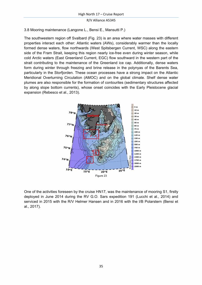
The southwestern region off Svalbard (Fig. 23) is an area where water masses with different properties interact each other: Atlantic waters (AWs), considerably warmer than the locally formed dense waters, flow northwards (West Spitsbergen Current, WSC) along the eastern side of the Fram Strait, keeping this region nearly ice-free even during winter season, while cold Arctic waters (East Greenland Current, EGC) flow southward in the western part of the strait contributing to the maintenance of the Greenland ice cap. Additionally, dense waters form during winter through freezing and brine release in the polynyas of the Barents Sea, particularly in the Storfjorden. These ocean processes have a strong impact on the Atlantic Meridional Overturning Circulation (AMOC) and on the global climate. Shelf dense water plumes are also responsible for the formation of contourites (sedimentary structures affected by along slope bottom currents), whose onset coincides with the Early Pleistocene glacial expansion (Rebesco et al., 2013).
Figure 23
One of the activities foreseen by the cruise HN17, was the maintenance of mooring S1, firstly deployed in June 2014 during the RV G.O. Sars expedition 191 (Lucchi et al., 2014) and serviced in 2015 with the R/V Helmer Hansen and in 2016 with the I/B Polarstern (Bensi et al., 2017).
High North 17 – Cruise Report
R/V Alliance A5345
36
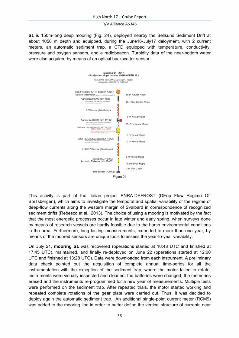
S1 is 150m-long deep mooring (Fig. 24), deployed nearby the Bellsund Sediment Drift at about 1050 m depth and equipped, during the June16-July17 deloyment, with 2 current meters, an automatic sediment trap, a CTD equipped with temperature, conductivity, pressure and oxygen sensors, and a radiobeacon. Turbidity data of the near-bottom water were also acquired by means of an optical backscatter sensor.
Figure 24
This activity is part of the Italian project PNRA-DEFROST (DEep Flow Regime Off SpiTsbergen), which aims to investigate the temporal and spatial variability of the regime of deep-flow currents along the western margin of Svalbard in correspondence of recognized sediment drifts (Rebesco et al., 2013). The choice of using a mooring is motivated by the fact that the most energetic processes occur in late winter and early spring, when surveys done by means of research vessels are hardly feasible due to the harsh environmental conditions in the area. Furthermore, long lasting measurements, extended to more than one year, by means of the moored sensors are unique tools to assess the year-to-year variability.
On July 21, mooring S1 was recovered (operations started at 16:48 UTC and finished at 17:45 UTC), maintained, and finally re-deployed on June 22 (operations started at 12:00 UTC and finished at 13:28 UTC). Data were downloaded from each instrument. A preliminary data check pointed out the acquisition of complete annual time-series for all the instrumentation with the exception of the sediment trap, where the motor failed to rotate. Instruments were visually inspected and cleaned, the batteries were changed, the memories erased and the instruments re-programmed for a new year of measurements. Multiple tests were performed on the sediment trap. After repeated trials, the motor started working and repeated complete rotations of the gear plate were carried out. Thus, it was decided to deploy again the automatic sediment trap. An additional single-point current meter (RCM9) was added to the mooring line in order to better define the vertical structure of currents near
High North 17 – Cruise Report
R/V Alliance A5345
37
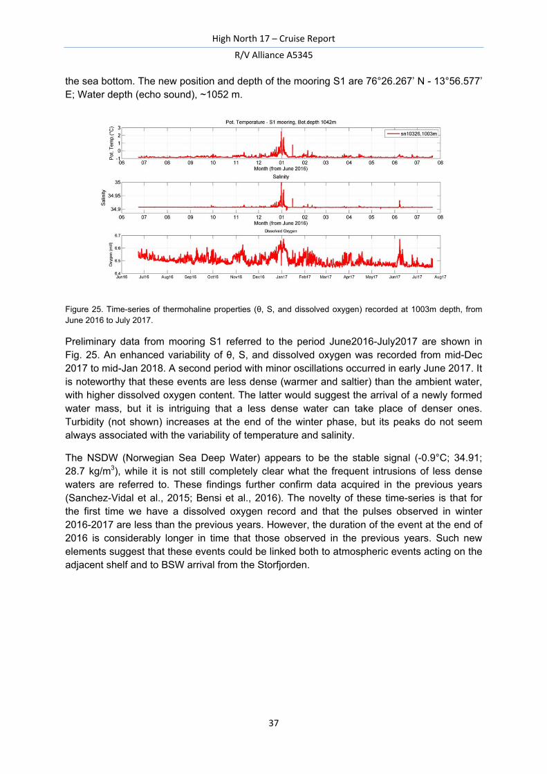
the sea bottom. The new position and depth of the mooring S1 are 76°26.267’ N - 13°56.577’ E; Water depth (echo sound), ~1052 m.
Figure 25. Time-series of thermohaline properties (θ, S, and dissolved oxygen) recorded at 1003m depth, from June 2016 to July 2017.
Preliminary data from mooring S1 referred to the period June2016-July2017 are shown in Fig. 25. An enhanced variability of θ, S, and dissolved oxygen was recorded from mid-Dec 2017 to mid-Jan 2018. A second period with minor oscillations occurred in early June 2017. It is noteworthy that these events are less dense (warmer and saltier) than the ambient water, with higher dissolved oxygen content. The latter would suggest the arrival of a newly formed water mass, but it is intriguing that a less dense water can take place of denser ones. Turbidity (not shown) increases at the end of the winter phase, but its peaks do not seem always associated with the variability of temperature and salinity.
The NSDW (Norwegian Sea Deep Water) appears to be the stable signal (-0.9°C; 34.91; 28.7 kg/m3), while it is not still completely clear what the frequent intrusions of less dense waters are referred to. These findings further confirm data acquired in the previous years (Sanchez-Vidal et al., 2015; Bensi et al., 2016). The novelty of these time-series is that for the first time we have a dissolved oxygen record and that the pulses observed in winter 2016-2017 are less than the previous years. However, the duration of the event at the end of 2016 is considerably longer in time that those observed in the previous years. Such new elements suggest that these events could be linked both to atmospheric events acting on the adjacent shelf and to BSW arrival from the Storfjorden.
High North 17 – Cruise Report
R/V Alliance A5345
38
3.9 Public Information (Biavasco A., Carlevaro M., Cassinis A., Moschetto N.)
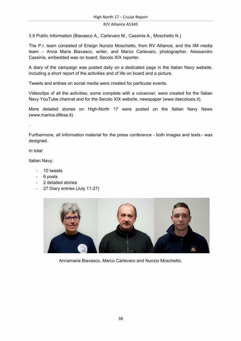
The P.I. team consisted of Ensign Nunzio Moschetto, from RV Alliance, and the IIM media team – Anna Maria Biavasco, writer, and Marco Carlevaro, photographer. Alessandro Cassinis, embedded was on board, Secolo XIX reporter.
A diary of the campaign was posted daily on a dedicated page in the Italian Navy website, including a short report of the activities and of life on board and a picture.
Tweets and entries on social media were created for particular events.
Videoclips of all the activities, some complete with a voiceover, were created for the Italian Navy YouTube channel and for the Secolo XIX website, newspaper (www.ilsecoloxix.it).
More detailed stories on High-North 17 were posted on the Italian Navy News (www.marina.difesa.it).
.
Furthermore, all information material for the press conference - both images and texts.- was designed.
In total:
Italian Navy: - 10 tweets - 6 posts - 2 detailed stories - 27 Diary entries (July 11-27)
Annamaria Biavasco, Marco Carlevaro and Nunzio Moschetto.
High North 17 – Cruise Report
R/V Alliance A5345
39
4. References
Bensi M., V. Kovacevic, M. Rebesco, L. Ursella, D. Deponte, L. Langone, S. Aliani, S. Miserocchi, A. Wåhlin, T. Soltwedel, I. Goszczko, R. Skogseth (2016). Preliminary results of the oceanographic features of the bottom density-driven currents on the Storfjorden continental slope (Svalbard), ARCA final conference, Rome (Italy), 11 Oct. 2016.
Bensi M. et al. 2017. DEFROST (DEep Flow Regime Off SpiTsbergen) Cruise Report. OGS Report n° 2017/10 Sez. OCE 5 EXO.
Carpenter, 1965. Accuracy of the Winkler method for the dissolved oxygen analysis, Limnol. Oceanogr. 10, 135–140
Fer, I., R. Skogseth, and P. M. Haugan (2004), Mixing of the Storfjorden overflow (Svalbard Archipelago) inferred from
density overturns, J. Geophys. Res., 109, C01005, doi:10.1029/2003JC001968.
Grasshoff, K., Kremling, K., Ehrhardt, M., 1999. Methods of Seawater Analysis, 3rd Edition, Wiley-VCH, Weinheim, 600 pp.
Lucchi, R.G., Kovacevic, V., Aliani, S., Caburlotto, A., Celussi, M., Corgnati, L., Cosoli, S., Deponte, D., Ersdal, E.A., Fredriksson, S., Goszczko, I., Husum, K., Ingrosso, G., Laberg, J.S., Lacka, M., Langone, L., Mansutti, P., Mezgec, K., Morigi, C., Ponomarenko, E., Realdon, G., Relitti, F., Robijn, A., Skogseth, R., Tirelli, V., 2014. PREPARED: Present and past flow regime on contourite drifts west of Spitsbergen. EUROFLEETS-2 Cruise Summary Report, R/V G.O. Sars Cruise No. 191, 05/06/2014 – 15/06/2014, Tromsø – Tromsø (Norway), 89 pp.
Rebesco, M., et al. (2013). Quaternary contourite drifts of the Western Spitsbergen margin. Deep-Sea Research I, 79, 156-168, doi:10.1016/j.dsr.2013.05.013.
Sanchez-Vidal, A., Veres, O., Langone, L., Ferré, B., Calafat, A., Canals, M., Durrieu de Madron, X., Heussner, S., Mienert, J., Grimalt, J.O., Pusceddu, A., Danovaro, R., 2015. Particle sources and downward fluxes in the eastern Fram strait under the influence of the west Spitsbergen current. Deep-Sea Research Part I 103, 49-63.
Schlitzer R., 2002. Ocean Data View, ⟨http://www.awi-bremerhaven.de/GEO/ODV⟨.
High North 17 – Cruise Report
R/V Alliance A5345
40
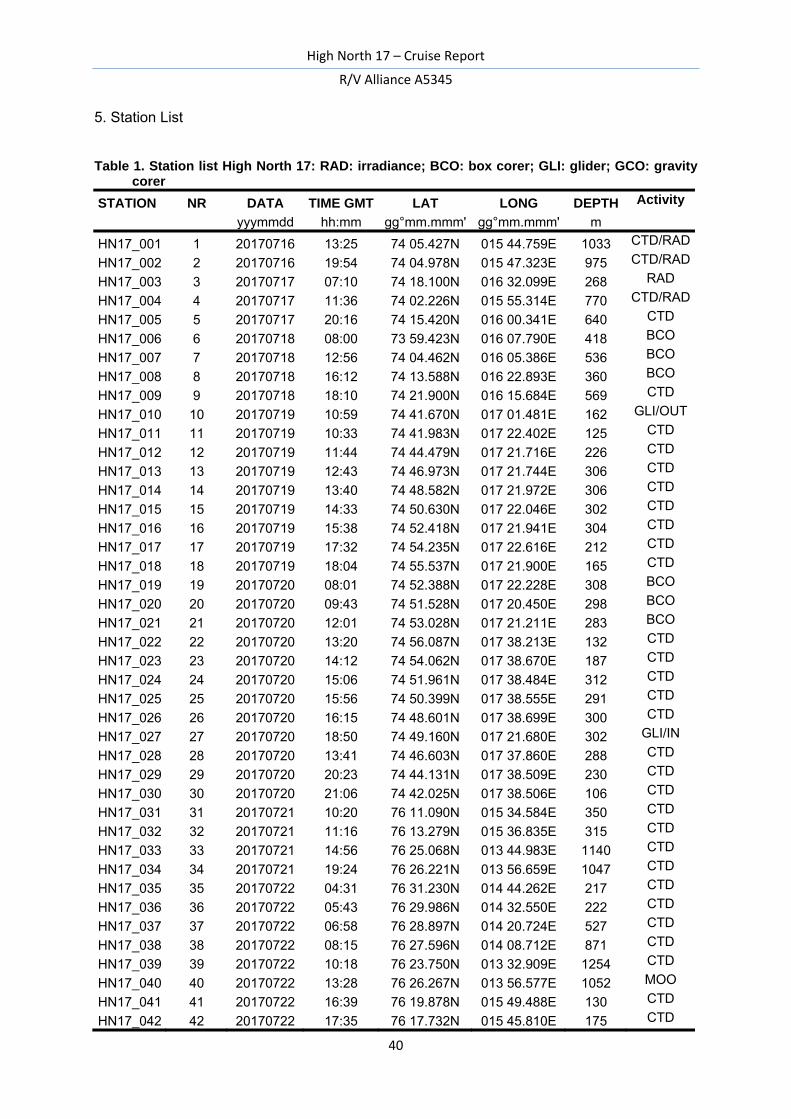
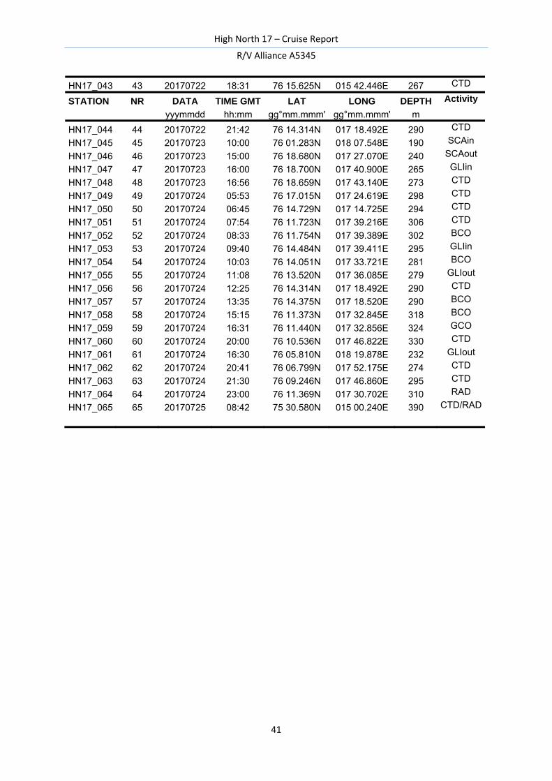
5. Station List
Table 1. Station list High North 17: RAD: irradiance; BCO: box corer; GLI: glider; GCO: gravity
corer
STATION NR DATA TIME GMT LAT LONG DEPTH Activity
yyymmdd hh:mm gg°mm.mmm' gg°mm.mmm' m
HN17_001 1 20170716 13:25 74 05.427N 015 44.759E 1033 CTD/RAD
HN17_002 2 20170716 19:54 74 04.978N 015 47.323E 975 CTD/RAD
HN17_003 3 20170717 07:10 74 18.100N 016 32.099E 268 RAD
HN17_004 4 20170717 11:36 74 02.226N 015 55.314E 770 CTD/RAD
HN17_005 5 20170717 20:16 74 15.420N 016 00.341E 640 CTD
HN17_006 6 20170718 08:00 73 59.423N 016 07.790E 418 BCO
HN17_007 7 20170718 12:56 74 04.462N 016 05.386E 536 BCO
HN17_008 8 20170718 16:12 74 13.588N 016 22.893E 360 BCO
HN17_009 9 20170718 18:10 74 21.900N 016 15.684E 569 CTD
HN17_010 10 20170719 10:59 74 41.670N 017 01.481E 162 GLI/OUT
HN17_011 11 20170719 10:33 74 41.983N 017 22.402E 125 CTD
HN17_012 12 20170719 11:44 74 44.479N 017 21.716E 226 CTD
HN17_013 13 20170719 12:43 74 46.973N 017 21.744E 306 CTD
HN17_014 14 20170719 13:40 74 48.582N 017 21.972E 306 CTD
HN17_015 15 20170719 14:33 74 50.630N 017 22.046E 302 CTD
HN17_016 16 20170719 15:38 74 52.418N 017 21.941E 304 CTD
HN17_017 17 20170719 17:32 74 54.235N 017 22.616E 212 CTD
HN17_018 18 20170719 18:04 74 55.537N 017 21.900E 165 CTD
HN17_019 19 20170720 08:01 74 52.388N 017 22.228E 308 BCO
HN17_020 20 20170720 09:43 74 51.528N 017 20.450E 298 BCO
HN17_021 21 20170720 12:01 74 53.028N 017 21.211E 283 BCO
HN17_022 22 20170720 13:20 74 56.087N 017 38.213E 132 CTD
HN17_023 23 20170720 14:12 74 54.062N 017 38.670E 187 CTD
HN17_024 24 20170720 15:06 74 51.961N 017 38.484E 312 CTD
HN17_025 25 20170720 15:56 74 50.399N 017 38.555E 291 CTD
HN17_026 26 20170720 16:15 74 48.601N 017 38.699E 300 CTD
HN17_027 27 20170720 18:50 74 49.160N 017 21.680E 302 GLI/IN
HN17_028 28 20170720 13:41 74 46.603N 017 37.860E 288 CTD
HN17_029 29 20170720 20:23 74 44.131N 017 38.509E 230 CTD
HN17_030 30 20170720 21:06 74 42.025N 017 38.506E 106 CTD
HN17_031 31 20170721 10:20 76 11.090N 015 34.584E 350 CTD
HN17_032 32 20170721 11:16 76 13.279N 015 36.835E 315 CTD
HN17_033 33 20170721 14:56 76 25.068N 013 44.983E 1140 CTD
HN17_034 34 20170721 19:24 76 26.221N 013 56.659E 1047 CTD
HN17_035 35 20170722 04:31 76 31.230N 014 44.262E 217 CTD
HN17_036 36 20170722 05:43 76 29.986N 014 32.550E 222 CTD
HN17_037 37 20170722 06:58 76 28.897N 014 20.724E 527 CTD
HN17_038 38 20170722 08:15 76 27.596N 014 08.712E 871 CTD
HN17_039 39 20170722 10:18 76 23.750N 013 32.909E 1254 CTD
HN17_040 40 20170722 13:28 76 26.267N 013 56.577E 1052 MOO
HN17_041 41 20170722 16:39 76 19.878N 015 49.488E 130 CTD
HN17_042 42 20170722 17:35 76 17.732N 015 45.810E 175 CTD
High North 17 – Cruise Report
R/V Alliance A5345
41
HN17_043 43 20170722 18:31 76 15.625N 015 42.446E 267 CTD
STATION NR DATA TIME GMT LAT LONG DEPTH Activity
yyymmdd hh:mm gg°mm.mmm' gg°mm.mmm' m
HN17_044 44 20170722 21:42 76 14.314N 017 18.492E 290 CTD
HN17_045 45 20170723 10:00 76 01.283N 018 07.548E 190 SCAin
HN17_046 46 20170723 15:00 76 18.680N 017 27.070E 240 SCAout
HN17_047 47 20170723 16:00 76 18.700N 017 40.900E 265 GLIin
HN17_048 48 20170723 16:56 76 18.659N 017 43.140E 273 CTD
HN17_049 49 20170724 05:53 76 17.015N 017 24.619E 298 CTD
HN17_050 50 20170724 06:45 76 14.729N 017 14.725E 294 CTD
HN17_051 51 20170724 07:54 76 11.723N 017 39.216E 306 CTD
HN17_052 52 20170724 08:33 76 11.754N 017 39.389E 302 BCO
HN17_053 53 20170724 09:40 76 14.484N 017 39.411E 295 GLIin
HN17_054 54 20170724 10:03 76 14.051N 017 33.721E 281 BCO
HN17_055 55 20170724 11:08 76 13.520N 017 36.085E 279 GLIout
HN17_056 56 20170724 12:25 76 14.314N 017 18.492E 290 CTD
HN17_057 57 20170724 13:35 76 14.375N 017 18.520E 290 BCO
HN17_058 58 20170724 15:15 76 11.373N 017 32.845E 318 BCO
HN17_059 59 20170724 16:31 76 11.440N 017 32.856E 324 GCO
HN17_060 60 20170724 20:00 76 10.536N 017 46.822E 330 CTD
HN17_061 61 20170724 16:30 76 05.810N 018 19.878E 232 GLIout
HN17_062 62 20170724 20:41 76 06.799N 017 52.175E 274 CTD
HN17_063 63 20170724 21:30 76 09.246N 017 46.860E 295 CTD
HN17_064 64 20170724 23:00 76 11.369N 017 30.702E 310 RAD
HN17_065 65 20170725 08:42 75 30.580N 015 00.240E 390 CTD/RAD
High North 17 – Cruise Report
R/V Alliance A5345
42
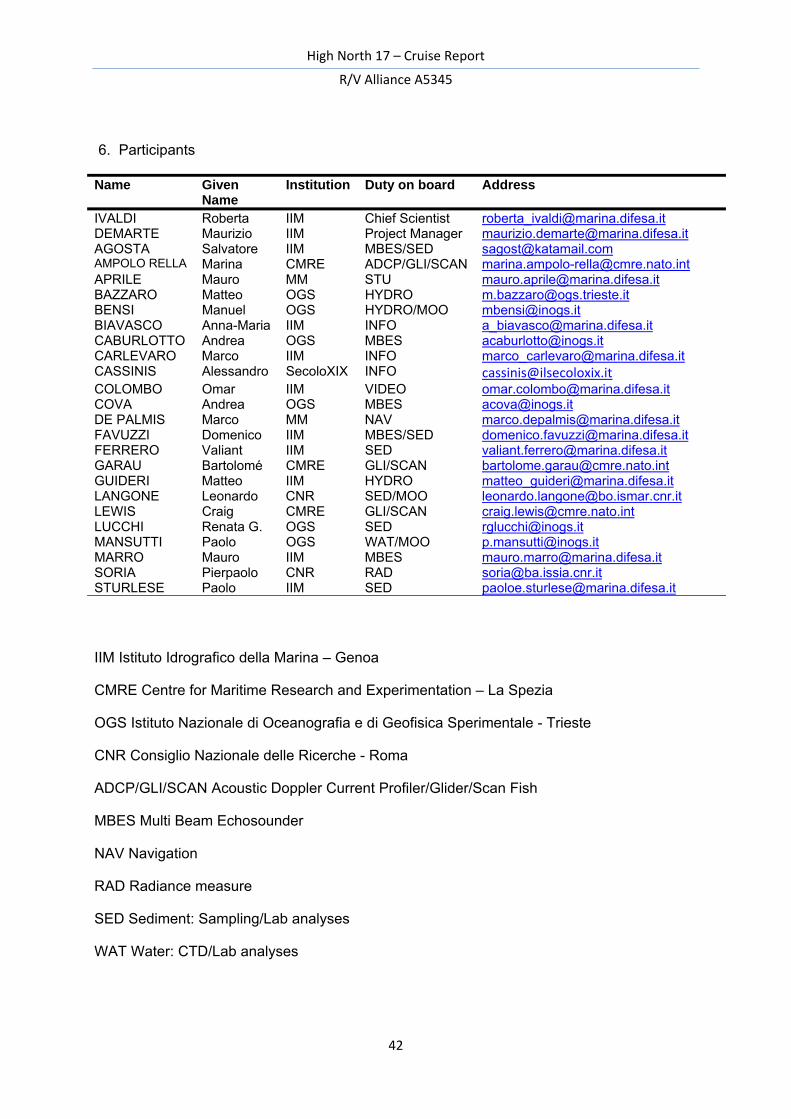
6. Participants
Name Given Name
Institution Duty on board Address
IVALDI Roberta IIM Chief Scientist [email protected] DEMARTE Maurizio IIM Project Manager [email protected] AGOSTA Salvatore IIM MBES/SED [email protected] AMPOLO RELLA Marina CMRE ADCP/GLI/SCAN [email protected] APRILE Mauro MM STU [email protected] BAZZARO Matteo OGS HYDRO [email protected] BENSI Manuel OGS HYDRO/MOO [email protected] BIAVASCO Anna-Maria IIM INFO [email protected] CABURLOTTO Andrea OGS MBES [email protected] CARLEVARO Marco IIM INFO [email protected] CASSINIS Alessandro SecoloXIX INFO [email protected] COLOMBO Omar IIM VIDEO [email protected] COVA Andrea OGS MBES [email protected] DE PALMIS Marco MM NAV [email protected] FAVUZZI Domenico IIM MBES/SED [email protected] FERRERO Valiant IIM SED [email protected] GARAU Bartolomé CMRE GLI/SCAN [email protected] GUIDERI Matteo IIM HYDRO [email protected] LANGONE Leonardo CNR SED/MOO [email protected] LEWIS Craig CMRE GLI/SCAN [email protected] LUCCHI Renata G. OGS SED [email protected] MANSUTTI Paolo OGS WAT/MOO [email protected] MARRO Mauro IIM MBES [email protected] SORIA Pierpaolo CNR RAD [email protected] STURLESE Paolo IIM SED [email protected]
IIM Istituto Idrografico della Marina – Genoa
CMRE Centre for Maritime Research and Experimentation – La Spezia
OGS Istituto Nazionale di Oceanografia e di Geofisica Sperimentale - Trieste
CNR Consiglio Nazionale delle Ricerche - Roma
ADCP/GLI/SCAN Acoustic Doppler Current Profiler/Glider/Scan Fish
MBES Multi Beam Echosounder
NAV Navigation
RAD Radiance measure
SED Sediment: Sampling/Lab analyses
WAT Water: CTD/Lab analyses
High North 17 – Cruise Report
R/V Alliance A5345
43
Acknowledgements
Many people contributed to the success of the cruise. First, we wish to thank the Commanding Officer Commander Ettore RONCO, the Officers and the crew of R/V Alliance for their professional work and their cooperative and helpful attitude which ensured successful operation during the whole cruise and the acquisition of a vast set of high quality oceanographic and geophysical data. All Scientific Team would like to thank Captain Luigi SINAPI, National Hydrographer at the Italian Hydrographic Institute for his precious support before, during and after the High North 17.

High North 17 – Cruise Report
R/V Alliance A5345
High North 17 – Cruise Report
R/V Alliance A5345
APPENDIX
High North 17 – Cruise Report
R/V Alliance A5345
High North 17 – Cruise Report
R/V Alliance A5345
High North 17 – Cruise Report
R/V Alliance A5345
High North 17 – Cruise Report
R/V Alliance A5345
High North 17 – Cruise Report
R/V Alliance A5345
High North 17 – Cruise Report
R/V Alliance A5345
High North 17 – Cruise Report
R/V Alliance A5345
High North 17 – Cruise Report
R/V Alliance A5345
High North 17 – Cruise Report
R/V Alliance A5345
High North 17 – Cruise Report
R/V Alliance A5345

HIGH NORTH 17CRUISE REPORT
I.I. 3180
ISTITUTO IDROGRAFICO DELLA MARINA
GENOVA 2017
ARCTIC MARINEGEOPHySICAl CAMPAIGN