Amanda Putri, A/Prof. Stuart Pearson, A/Prof. Xiao Hua Wang, Dr ...
1
Cope with changing environments: Insights from the coast of Jakarta School of Physical, Environmental and Mathematical Sciences References Mustaruddin. 2013. Pola pencemaran Hg dan Pb pada fishing ground dan ikan yang tertangkap nelayan: Studi kasus di Teluk Jakarta. [Mercury and lead contamination pattern on fish and fishing ground: A case study in Jakarta Bay]. Jurnal Bumi Lestari 13(2):214-224. Putri, A., S. Pearson, and W. Windupranata. 2015. Sustaining the environments - sustaining the livelihoods: Insights from the coast of Jakarta, Indonesia. Proc. of Indonesian Scholars International Convention: 20-30, available via http://www.isic- tiimi.co.uk/uploads/3/5/7/2/3572419/final_conference_proceeding_211_pages.pdf van Lavieren, H., J. Burt, D. A. Feary, G. Cavalcante, E. Marquis, L. Benedetti, C. Trick, B. Kjerfve, and P. F. Sale. 2011. Managing the growing impacts of development on fragile coastal and marine ecosystems: Lessons from the Gulf. In A policy report, Hamilton, ON, Canada: UNU-INWEH. BACKGROUND: Jakarta Bay and environmental degradation Water quality degradation in Jakarta Bay has been a serious challenge relatively well documented for decades. Located on the edge of densely settled coastal megacity, this Bay suffers from destruction of habitats and ecosystem shifts (van Lavieren, 2011). Chemical and biophysical indicators have shown concerning levels of contamination in the waters, sediments, and fish of Jakarta Bay. This exposure is expected to affect the traditional fishery sectors and communities that use Jakarta Bay as their primary fishing area (Mustaruddin, 2013). Floating litter - Cilincing village There is a research gap in how the decline in water quality impacts the traditional fisheries. This PhD uses a multidisciplinary approach to survey people and achieve a better understanding of how the communities cope with water pollution as a stressor and how it affects their livelihood (Putri et al, 2015). In addition, water quality data is used to obtain a comprehensive description and spatial statistical analysis about the state of Jakarta Bay’s water. Together these will give powerful insights into the vulnerability and management options for the fisheries-based communities. METHODOLOGY: Combining local knowledge and biophysical model Qualitative Quantitative Socio-economic/ Livelihood Fishing activities Quantitative Water quality Environmental data Livelihood analysis Vulnerability assessment Adaptation strategies A face-to-face questionnaire in Indonesian with 286 respondents (grouped by traditional fishers, mussel farmers, and informal workers) in 2 fishing villages provides livelihood data. Group discussions, involving 22 community members in participatory exercises such as mapping, problem-listing, creating time-lines and a seasonal calendar, provide information about changing fisheries activities. INSIGHTS: Fishery activities and water quality Amanda Putri, A/Prof. Stuart Pearson, A/Prof. Xiao Hua Wang, Dr. Nicolaas Warouw Water quality data obtained from the Jakarta Environmental Management Agency (BPLHD) for the period of 2001-2013 for 23 observation points. This includes time series data of dissolved oxygen, turbidity, nutrients, heavy metals and other water parameters. Participatory maps describe past and current fishing area and mussel farming locations. Red circle defines the degraded area according to fishers. Spatial shifting, one of distinctive adaptation strategies, was observed by traditional fishers but not by mussel farmers because they needed shallow and more turbid waters. Floating litter and fisherman- Muara Angke village 106°55'0"E 106°50'0"E 106°45'0"E 106°40'0"E 6°0'0"S 6°5'0"S 6°10'0"S JAKARTA BAY P. Damar P. Untung Jawa P. Rambut P. Bidadari Muara Angke 0 2 4 1 Kilometers ¯ Special Capital Region (DKI) of Jakarta Fishing Port ! < River mouths Past avg fishing radius Current avg fishing radius Past mussel area Current mussel area Cilincing Clustered map of Jakarta Bay water quality, generated by SPSS and ArcGIS software, shows 5 distinctive clusters using the characteristics of water samples gathered by BPLHD. Biophysical data show the exposure to contaminants in near-shore areas. 2 1 3 4 5 Further analysis on the integration of local knowledge and biophysical model is in progress. This is important to obtain deeper understanding of water pollution impacts on the communities and to assess the exposure to different community groups. That understanding will contribute to the vulnerability assessment and inform decision-makers. RESEARCH GAP
-
Upload
phungkhanh -
Category
Documents
-
view
222 -
download
1
Transcript of Amanda Putri, A/Prof. Stuart Pearson, A/Prof. Xiao Hua Wang, Dr ...
Cope with changing environments:
Insights from the coast of Jakarta
School of Physical, Environmental and Mathematical Sciences
References Mustaruddin. 2013. Pola pencemaran Hg dan Pb pada fishing ground dan ikan yang tertangkap nelayan: Studi kasus di Teluk Jakarta. [Mercury and lead contamination pattern on fish and fishing ground: A case study in Jakarta Bay]. Jurnal Bumi Lestari 13(2):214-224. Putri, A., S. Pearson, and W. Windupranata. 2015. Sustaining the environments - sustaining the livelihoods: Insights from the coast of Jakarta, Indonesia. Proc. of Indonesian Scholars International Convention: 20-30, available via http://www.isic-tiimi.co.uk/uploads/3/5/7/2/3572419/final_conference_proceeding_211_pages.pdf van Lavieren, H., J. Burt, D. A. Feary, G. Cavalcante, E. Marquis, L. Benedetti, C. Trick, B. Kjerfve, and P. F. Sale. 2011. Managing the growing impacts of development on fragile coastal and marine ecosystems: Lessons from the Gulf. In A policy report, Hamilton, ON, Canada: UNU-INWEH.
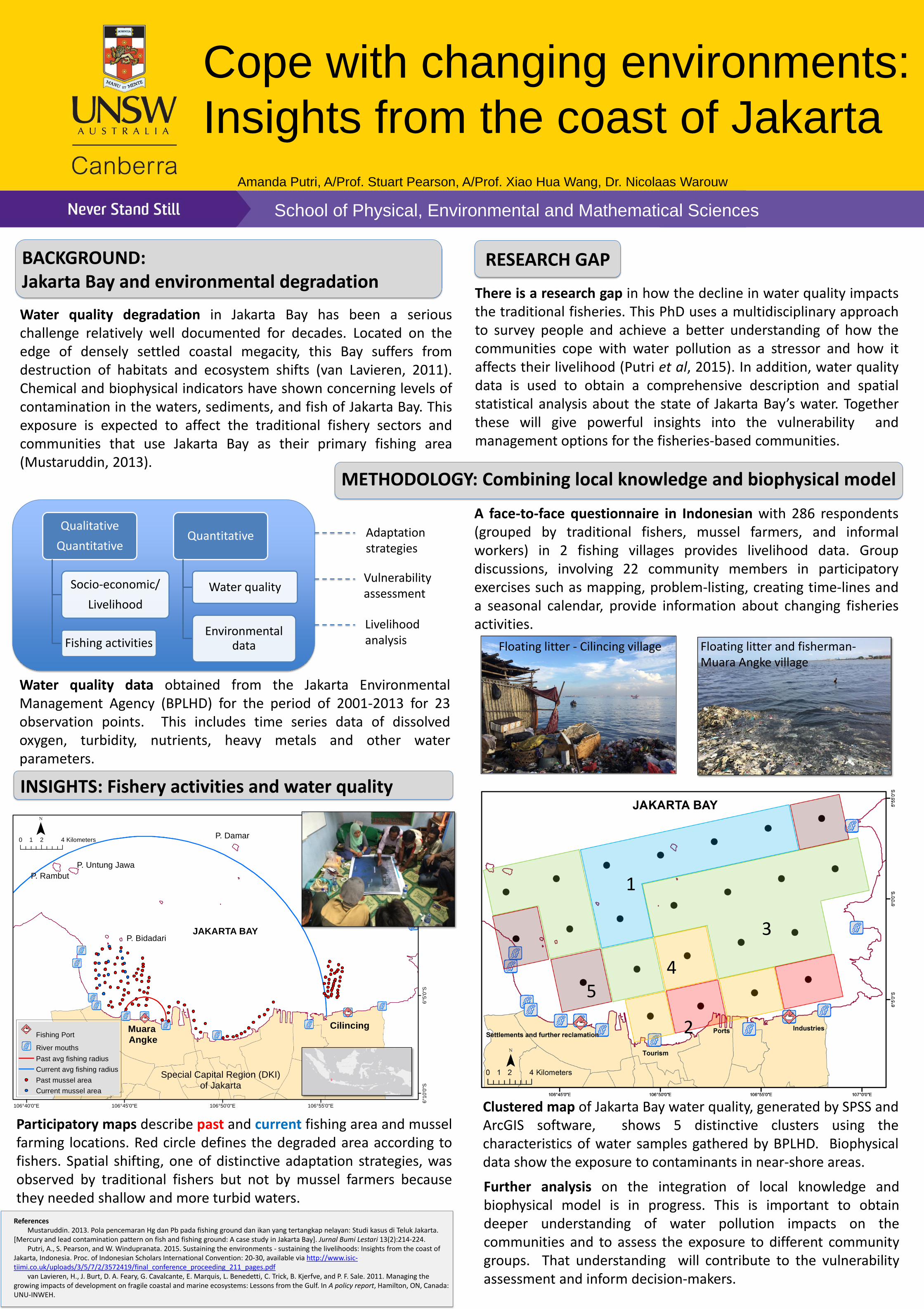
BACKGROUND: Jakarta Bay and environmental degradation Water quality degradation in Jakarta Bay has been a serious challenge relatively well documented for decades. Located on the edge of densely settled coastal megacity, this Bay suffers from destruction of habitats and ecosystem shifts (van Lavieren, 2011). Chemical and biophysical indicators have shown concerning levels of contamination in the waters, sediments, and fish of Jakarta Bay. This exposure is expected to affect the traditional fishery sectors and communities that use Jakarta Bay as their primary fishing area (Mustaruddin, 2013).
Floating litter - Cilincing village
There is a research gap in how the decline in water quality impacts the traditional fisheries. This PhD uses a multidisciplinary approach to survey people and achieve a better understanding of how the communities cope with water pollution as a stressor and how it affects their livelihood (Putri et al, 2015). In addition, water quality data is used to obtain a comprehensive description and spatial statistical analysis about the state of Jakarta Bay’s water. Together these will give powerful insights into the vulnerability and management options for the fisheries-based communities.
METHODOLOGY: Combining local knowledge and biophysical model
Qualitative
Quantitative
Socio-economic/
Livelihood
Fishing activities
Quantitative
Water quality
Environmental data
Livelihood analysis
Vulnerability assessment
Adaptation strategies
A face-to-face questionnaire in Indonesian with 286 respondents (grouped by traditional fishers, mussel farmers, and informal workers) in 2 fishing villages provides livelihood data. Group discussions, involving 22 community members in participatory exercises such as mapping, problem-listing, creating time-lines and a seasonal calendar, provide information about changing fisheries activities.
INSIGHTS: Fishery activities and water quality
Amanda Putri, A/Prof. Stuart Pearson, A/Prof. Xiao Hua Wang, Dr. Nicolaas Warouw
Water quality data obtained from the Jakarta Environmental Management Agency (BPLHD) for the period of 2001-2013 for 23 observation points. This includes time series data of dissolved oxygen, turbidity, nutrients, heavy metals and other water parameters.
Participatory maps describe past and current fishing area and mussel farming locations. Red circle defines the degraded area according to fishers. Spatial shifting, one of distinctive adaptation strategies, was observed by traditional fishers but not by mussel farmers because they needed shallow and more turbid waters.
Floating litter and fisherman- Muara Angke village
106°55'0"E106°50'0"E106°45'0"E106°40'0"E
6°0
'0"S
6°5
'0"S
6°1
0'0
"S
JAKARTA BAY
P. Damar
P. Untung Jawa
P. Rambut
P. Bidadari
Muara Angke
0 2 41 Kilometers¯
Special Capital Region (DKI)of Jakarta
Fishing Port
!< River mouths
Past avg fishing radius
Current avg fishing radius
Past mussel area
Current mussel area
Cilincing
Clustered map of Jakarta Bay water quality, generated by SPSS and ArcGIS software, shows 5 distinctive clusters using the characteristics of water samples gathered by BPLHD. Biophysical data show the exposure to contaminants in near-shore areas.
2
1
3
4 5
Further analysis on the integration of local knowledge and biophysical model is in progress. This is important to obtain deeper understanding of water pollution impacts on the communities and to assess the exposure to different community groups. That understanding will contribute to the vulnerability assessment and inform decision-makers.
RESEARCH GAP