ABORIGINAL DUE DILIGENCE REPORT
28
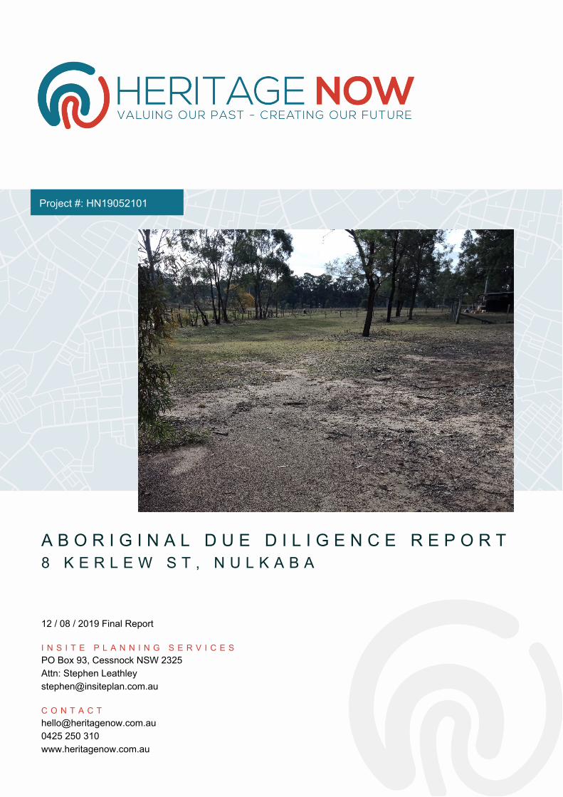
ABORIGINAL DUE DILIGENCE REPORT 8 KERLEW ST, NULKABA 12 / 08 / 2019 Final Report INSITE PLANNING SERVICES PO Box 93, Cessnock NSW 2325 Attn: Stephen Leathley [email protected] CONTACT [email protected] 0425 250 310 www.heritagenow.com.au Project #: HN19052101
Transcript of ABORIGINAL DUE DILIGENCE REPORT
A B O R I G I N A L D U E D I L I G E N C E R E P O R T 8 K E R L E W S T , N U L K A B A 12 / 08 / 2019 Final Report I N S I T E P L A N N I N G S E R V I C E S PO Box 93, Cessnock NSW 2325 Attn: Stephen Leathley [email protected] C O N T A C T [email protected] 0425 250 310 www.heritagenow.com.au
Project #: HN19052101
A B O R I G I N A L D U E D I L I G E N C E R E P O R T N U L K A B A | H N 1 9 0 5 2 1 0 1
I
Executive Summary This report has fulfilled the requirements under the Due Diligence Code of Practice for the Protection of Aboriginal Objects in NSW (OEH, formerly DECCW 2010). The Aboriginal Heritage Information Management System (AHIMS) was searched, but no Aboriginal sites have been previously registered in the Study Area. This report has also considered the landscape features and the environmental context of the Study Area.
The site inspection of the Study Area was undertaken with Jason Brown from Mindaribba Local Aboriginal Land Council. No Aboriginal objects, places or specific cultural areas were identified from the site inspection of the Study Area.
This report has assessed Aboriginal heritage in the Study Area and has identified there are no heritage constraints to rezoning the heritage area. The proposed rezoning will not affect the heritage significance of the area. This report provides adequate assessment of the Study Area as per clause 5.10(8) of the Cessnock LEP and is consistent with the s117 direction.
Concluding Statement
There are no identified Aboriginal heritage constraints in relation to the rezoning of the Study Area.
A B O R I G I N A L D U E D I L I G E N C E R E P O R T N U L K A B A | H N 1 9 0 5 2 1 0 1
II
Contents Introduction ............................................................................................................................................ 1
Study Area ........................................................................................................................................... 1
Project Proposal .................................................................................................................................. 1
Aboriginal Consultation ...................................................................................................................... 2
Report Details ..................................................................................................................................... 2
Legislative Context .................................................................................................................................. 3
National Parks and Wildlife Act 1974 ................................................................................................. 3
National Parks and Wildlife Regulations 2009 .................................................................................... 3
Environmental Planning and Assessment Act 1979 ............................................................................ 3
Environmental Context ........................................................................................................................... 5
Geology and Soils ................................................................................................................................ 5
Topography and Hydrology ................................................................................................................. 5
Flora and Fauna ................................................................................................................................... 5
Land Use .............................................................................................................................................. 6
Synthesis ............................................................................................................................................. 6
Heritage Context ..................................................................................................................................... 7
Aboriginal Heritage Information Management System (AHIMS) ....................................................... 7
Heritage Report Summaries ................................................................................................................ 8
Synthesis ........................................................................................................................................... 10
Site Visit ................................................................................................................................................ 11
Summary Statement ......................................................................................................................... 11
Impact Assessment ............................................................................................................................... 12
Conclusions and Recommendations ..................................................................................................... 13
References ........................................................................................................................................ 14
Plates ................................................................................................................................................. 15
Acronyms and Definitions ................................................................................................................. 17
Attachment 1 AHIMS Search ............................................................................................................. 18
Tables Table 1 Nulkaba Soils .............................................................................................................................. 5 Table 2 Summary of AHIMS Sites ............................................................................................................ 7
A B O R I G I N A L D U E D I L I G E N C E R E P O R T N U L K A B A | H N 1 9 0 5 2 1 0 1
III
Figures Figure 1: Study Area outlined in red ....................................................................................................... 1 Figure 2 Study Area with AHIMS Search ................................................................................................. 8
Plates
Plate 1 View west towards first order drainage line which has been dammed, dam in top right of photo. The dam is on the neighbouring property the boundary of the Study Area is demarcated by the fence. .............................................................................................................................................. 15 Plate 2 Study area was thinly covered in grass, view north. ................................................................ 15 Plate 3 Exposure near stables, view to east. ........................................................................................ 16 Plate 4 Silcrete cobble broken – but has not been worked and therefore is not classed as an Aboriginal object under the National Parks and Wildlife Act 1974. ..................................................... 16
A B O R I G I N A L D U E D I L I G E N C E R E P O R T N U L K A B A | H N 1 9 0 5 2 1 0 1
1
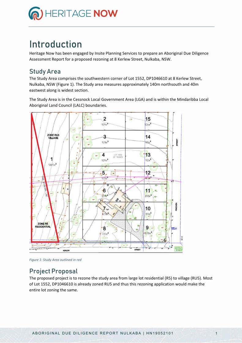
Introduction Heritage Now has been engaged by Insite Planning Services to prepare an Aboriginal Due Diligence Assessment Report for a proposed rezoning at 8 Kerlew Street, Nulkaba, NSW.
Study Area The Study Area comprises the southwestern corner of Lot 1552, DP1046610 at 8 Kerlew Street, Nulkaba, NSW (Figure 1). The Study area measures approximately 140m northsouth and 40m eastwest along is widest section.
The Study Area is in the Cessnock Local Government Area (LGA) and is within the Mindaribba Local Aboriginal Land Council (LALC) boundaries.
Figure 1: Study Area outlined in red
Project Proposal The proposed project is to rezone the study area from large lot residential (R5) to village (RU5). Most of Lot 1552, DP1046610 is already zoned RU5 and thus this rezoning application would make the entire lot zoning the same.
A B O R I G I N A L D U E D I L I G E N C E R E P O R T N U L K A B A | H N 1 9 0 5 2 1 0 1
2
Aboriginal Consultation Mindaribba LALC was consulted for this Aboriginal Due Diligence Assessment Report.
Report Details This report was written by Tessa Boer-Mah with input from Ty Rigby.
A B O R I G I N A L D U E D I L I G E N C E R E P O R T N U L K A B A | H N 1 9 0 5 2 1 0 1
3
Legislative Context This section provides an outline of the Acts, Regulations and guidelines under which this assessment has been undertaken. It is for information purposes only and should not be taken as legal advice.
National Parks and Wildlife Act 1974 This Act contains the provisions for protecting Aboriginal objects in NSW. Aboriginal objects are protected regardless of whether they are in their original context (location) or not and it is an offence to harm an Aboriginal object regardless of whether you know it is an Aboriginal object or not. Protection under Section 86 of the Act is as follows:
• s86(1) A person must not harm or desecrate an object that the person knows is an Aboriginal object.
• s86(2) A person must not harm an Aboriginal object. • s86(3) A person must not harm or desecrate an Aboriginal place.
Penalties for harming Aboriginal objects or Places range from $80,000-$800,000 for individuals and $330,000-$1,650,000 for corporations and may also include imprisonment. Under Section 87 there are certain defences from prosecution, these include that harm was authorised under an Aboriginal Heritage Impact Permit (AHIP) and actions were in accordance with the AHIP, that due diligence was exercised in relation to Aboriginal object/s and/or the activity was classified as low impact.
Under Section 89A Aboriginal object/s must be reported to the Office of Environment and Heritage (OEH) within a reasonable timeframe, unless it has previously been recorded and submitted to the Aboriginal Heritage Information Management System (AHIMS). Penalties for failure to report an Aboriginal object range from $16,500 for individuals and $33,000 for corporations.
National Parks and Wildlife Regulations 2009 This Regulation includes a framework for exercising due diligence and provides codes of practice in respect to Aboriginal objects (Section 80A) as well as defences for carrying out certain low impact activities (Section 80B). The Regulation also outlines requirements for Aboriginal consultation (Section 80C), particularly in relation to an Aboriginal Heritage Impact Permit. Under the Regulation the following codes of practice are recognised, amongst others:
• Due Diligence Code of Practice for the Protection of Aboriginal Objects in NSW (OEH, formerly DECCW 2010)
• NSW Minerals Industry Due Diligence Code of Practice for the Protection of Aboriginal Objects (Minerals Council)
Aboriginal Land Rights Act 1983 This Act provides land rights to Aboriginal people through the Local Aboriginal Land Councils. It outlines a process for claiming unused Crown Land in NSW and for creating land use. It also allows for agreements to permit traditional hunting, fishing and gathering.
Environmental Planning and Assessment Act 1979 The Environmental Planning and Assessment (EP&A) Act provides triggers for undertaking environmental and heritage assessments as part of the wider land use planning framework. Part 4
A B O R I G I N A L D U E D I L I G E N C E R E P O R T N U L K A B A | H N 1 9 0 5 2 1 0 1
4
outlines the how consent authorities are to determine development applications, as well as identifying whether projects require an environmental impact statement. Part 9 outlines the implementation and enforcement of the EP&A Act. As part of this, there are Section 117 directions (2017 renumbering as Section 9.1-9.5). The Section 117 directions include the following in respect to Aboriginal heritage:
2.3[4] A planning proposal must contain provisions that facilitate the conservation of:
a) items, places, buildings, works, relics, moveable objects or precincts of environmental heritage significance to an area, in relation to the historical, scientific, cultural, social, archaeological, architectural, natural or aesthetic value of the item, area, object or place, identified in a study of the environmental heritage of the area,
b) Aboriginal objects or Aboriginal places that are protected under the National Parks and Wildlife Act 1974, and
c) Aboriginal areas, Aboriginal objects, Aboriginal places or landscapes identified by an Aboriginal heritage survey prepared by or on behalf of an Aboriginal Land Council, Aboriginal body or public authority and provided to the relevant planning authority, which identifies the area, object, place or landscape as being of heritage significance to Aboriginal culture and people.
Cessnock Local Environmental Plan (LEP) 2011 The Cessnock LEP outlines triggers for heritage assessments as part of the Development Application process. It also protects heritage as listed in Schedule 5 of the LEP. The Finchley Aboriginal Area is protected under the Cessnock LEP, this area is not in the Study Area.
Section 5.10 of the Cessnock LEP outlines conservation objectives, requirements for consent, heritage assessment and management requirements, as well as conservation incentives.
With respect to Aboriginal heritage under section 5.10(8) it states that:
The consent authority must, before granting consent under this clause to the carrying out of development in an Aboriginal place of heritage significance:
(a) consider the effect of the proposed development on the heritage significance of the place and any Aboriginal object known or reasonably likely to be located at the place by means of an adequate investigation and assessment (which may involve consideration of a heritage impact statement), and
(b) notify the local Aboriginal communities, in writing or in such other manner as may be appropriate, about the application and take into consideration any response received within 28 days after the notice is sent.
A B O R I G I N A L D U E D I L I G E N C E R E P O R T N U L K A B A | H N 1 9 0 5 2 1 0 1
5
Environmental Context Aboriginal occupation was influenced by the environmental context, as such this section outlines the environment within, and surrounding, the Study Area to assist in the assessment of Aboriginal occupation patterns.
Geology and Soils Surface geology is defined as the Rutherford Formation consisting of siltstone, marl, and minor sandstones belonging to the early Permian to Permian period (Geoscience Australia, 1972). The soils formed are therefore part of the Permian Singleton Coal measures that stretch from Newcastle on the coast to Murrurundi at the north-western end of the Hunter Valley. The soils have formed from softer sandstones, mudstones, siltstones and conglomerates. The soil in the Study Area belongs to the Branxton soil landscape.
Local soils comprise loam topsoils which grades on to a B2 horizon of clay (NSW Soil and Land Information System, 2016). Based on the soil samples taken at Nulkaba (Table 1), archaeological deposits are most likely to occur in the A1 and B1 Horizons to a depth of approximately 50 cm. There is only a moderate potential for Aboriginal artefacts to occur in the B2 Horizon as it is predominantly comprised of clay with some sand inclusions.
Table 1 Nulkaba Soils
Layer 1 0.00-0.10m A Horizon
Dark greyish brown (greyish yellow brown) (10YR 4/2) [moist] silty clay loam with strong pedality (polyhedral, 20 - 50 mm, rough-faced peds), common (10-25/10x10cm) roots (2-5mm), field pH is 6.5; smooth abrupt (5-20 mm) boundary to Layer 2.
Layer 2 0.10 – 0.50m B1 Horizon
Brown (dull yellowish brown) (10YR 4/3) [moist] fine clay loam sandy with moderate pedality (polyhedral, 10 - 20 mm, rough-faced peds), few (1- 10/10x10cm) roots (1-2mm), few (1-10/10x10cm) roots (2-5mm), few (1- 2/10x10 cm) roots (>5mm), field pH is 6.5; gradual (50-100 mm) boundary to Layer 3.
Layer 3 0.50-0.85m B2 Horizon
Yellowish brown (dull yellowish brown) (10YR 5/4) [moist] medium clay with weak pedality (polyhedral, 20 - 50 mm, rough-faced peds), few (1- 10/10x10cm) roots (1-2mm), field pH is 6.0. Layer notes are: Sandy medium clay
Topography and Hydrology Located on the Cessnock river-plains, the site specifically is bordered by an ephemeral 2nd order stream on its Western border, at an approximately 80m Australian Height Datum and is relatively flat terrain. Major waterways nearby by include Black Creek approximately 1.5km to the East, and Oaky Creek 1km West-North-West. The Hunter River is located approximately 15km northeast of the Study Area.
Flora and Fauna The Study Area is located within the broad vegetation formation of the Hunter-Macleay Dry Sclerophyll Forests (Keith, 2006). Vegetation in the past was likely to have comprised an upper story of spotted gum, narrow-leaved ironbark, grey box, grey gum, grey iron bark and turpentine. Shrubs are likely to have included silver stemmed wattle, forest oak, coffee bush, gorse bitter pea, peach
A B O R I G I N A L D U E D I L I G E N C E R E P O R T N U L K A B A | H N 1 9 0 5 2 1 0 1
6
heath, large mock olive, narrow-leaved geebung and muttonwood (Keith, 2006, p. 124). Past fauna is likely to have included kangaroos, possums, gliders, reptiles and birds and thus would have provided food resources for Aboriginal people.
Land Use The land is currently used as a rural residence with open paddocks to the west of the dwelling. The lot has been subject to previous clearing and only regrowth trees remain.
Synthesis The geology suggests that there are no local outcrops of siliceous stone suitable for making artefacts. The soil landscape suggests that if subsurface Aboriginal artefacts were present they would be restricted to the upper 0.5m of topsoil (not accounting for local erosion). The terrain is relatively flat and therefore suitable for Aboriginal campsite occupation and the Study Area is located close to a first order stream which may have provided suitable drinking water. Flora and faunal resources were likely to have been present. The current land use has involved clearing of vegetation. Overall, the area is suitable for Aboriginal campsite occupation, but it is expected that more dense Aboriginal occupation would be located nearer to stream confluences and higher order streams.
A B O R I G I N A L D U E D I L I G E N C E R E P O R T N U L K A B A | H N 1 9 0 5 2 1 0 1
7
Heritage Context The heritage context outlines the previous Aboriginal sites that have been identified in the local area along with summaries of the heritage studies that have been undertaken.
Aboriginal Heritage Information Management System (AHIMS)
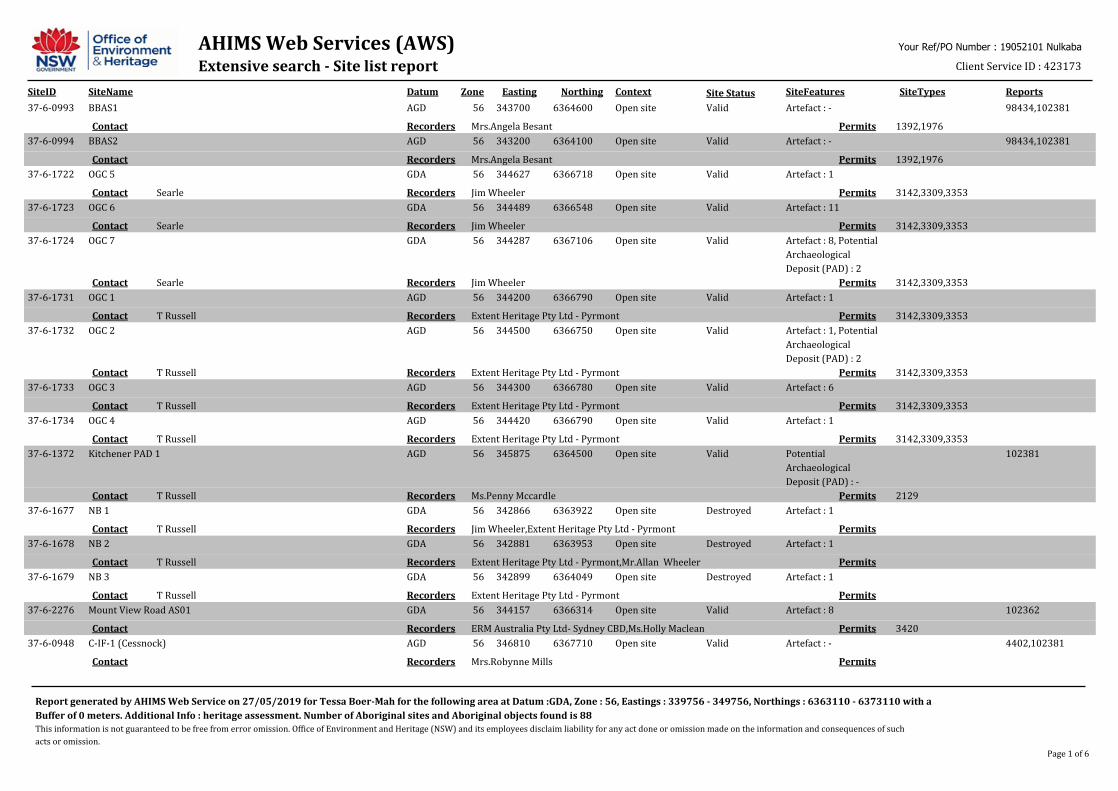
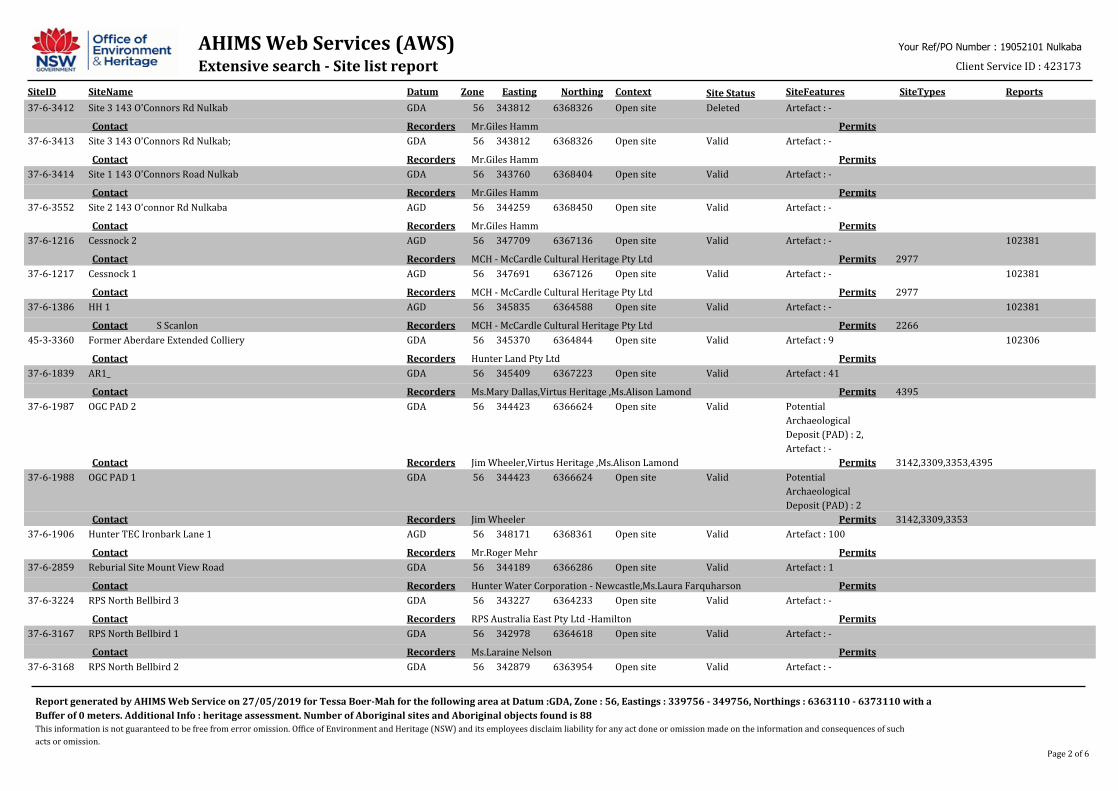
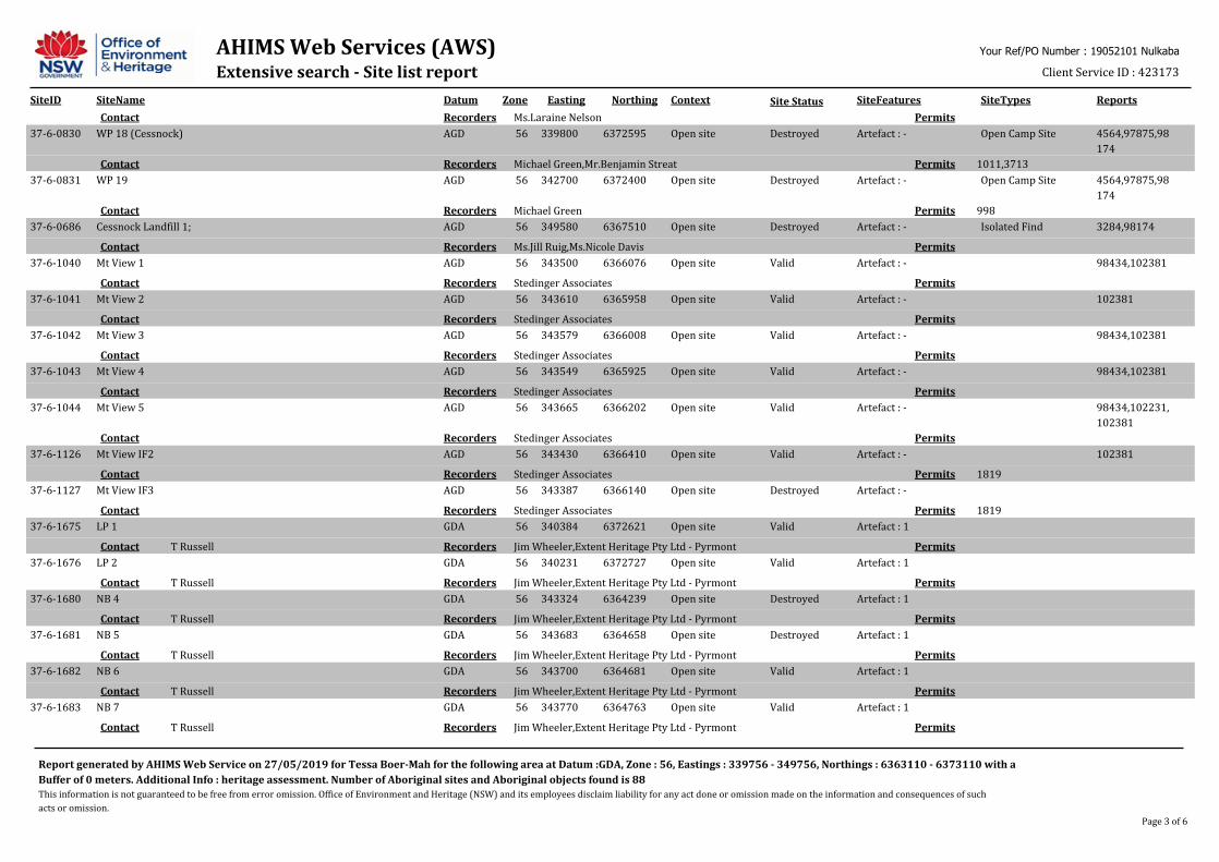
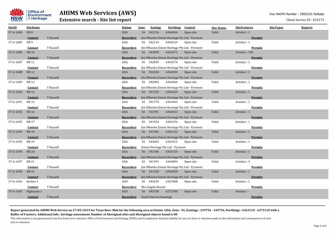
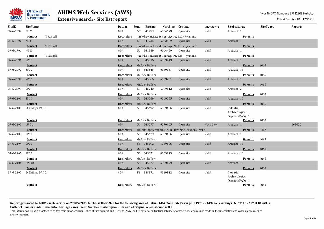
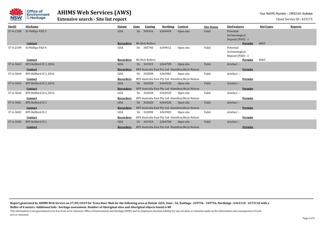
An Aboriginal Heritage Information Management System (AHIMS) search was conducted on the 27th of May, 2019. This search identified 88 Aboriginal Sites in the search area Eastings: 339756 - 349756, Northings: 6363110 – 6373110 (Table 2). None of these sites were in the Study Area, the closest being an isolated find located approximately 400m west and an artefact scatter located approximately 670m northwest (Figure 2).
Table 2 Summary of AHIMS Sites
Analysis of the AHIMS search results indicate 33 isolated artefact finds, 13 open artefact sites, 31 unspecified artefact sites totalling 77 artefacts. All these site types are characterised by having Aboriginal stone artefacts present. There were three PAD with artefacts and six registered PADs with no artefactual material. Of the 88 items recorded, 78 remain extant and 10 have been destroyed.
The AHIMS results show that stone artefacts are the main type of Aboriginal object identified in the local area. Based on the AHIMS results it would be unlikely for rockshelters, scarred trees, art sites or grinding grooves to be present.
Site Type Frequency Percentage Isolated finds 34 38.64% Open camp sites (Artefact scatters) 14 15.9% Artefact/s (number unspecified) 31 35.23% Potential Archaeological Deposit (PAD) with artefacts
3 3.41%
PAD 6 6.82% Total: 88 Destroyed: 10 Current Extant: 78
A B O R I G I N A L D U E D I L I G E N C E R E P O R T N U L K A B A | H N 1 9 0 5 2 1 0 1
8
Figure 2 Study Area with AHIMS Search
Heritage Report Summaries The following is a summary of heritage reports which have been conducted in the local area.
McCardle Heritage – Farley 2010
McArdle Heritage (MCH) (2010) prepared an Indigenous Archaeological Assessment for the identified land at Farley, approximately two kilometres south of Rutherford.
This Archaeological Assessment was carried out as part of plans to rezone the identified land to an appropriate residential zoning. The assessment was designed to identify areas of indigenous cultural heritage value, to determine possible impacts on any indigenous cultural heritage identified (including potential subsurface evidence) and to develop management recommendations where appropriate.
The on-site investigations were undertaken with local Aboriginal stakeholders. The investigations identified one artefact scatter and two isolated finds — all of which were disturbed and held little to no potential for in situ materials. One PAD was identified on the lands being assessed for re-zoning. MCH found no evidence of tool making, maintenance or repair, hearths, ovens, heat pits, high density and diversity of artefacts or grindstones that would indicate camping by indigenous populations.
The proposed rezoning was assessed as having no impact on extant archaeological sites. As part of mitigation strategies, MCH noted that any development following the re-zoning near to the PAD would require an archaeological subsurface investigation.
ERM – Cessnock Stages 1a and 1b upgrades (Hunter Water) 2011
Environmental Resource Management Australia (ERM) prepared a Heritage Assessment (HA) for lands to be impacted by a water pipeline upgrade in (2011). The HA considered Aboriginal and post-
A B O R I G I N A L D U E D I L I G E N C E R E P O R T N U L K A B A | H N 1 9 0 5 2 1 0 1
9
contact historic heritage, alongside archaeology, as a means to identify any potential risks to heritage values arising from the pipeline upgrades.
ERM conducted a detailed site survey, a comprehensive heritage values assessment, heritage impact analysis, and Aboriginal consultations. An AHIMs report also was utilised to develop a Predictive Aboriginal Heritage Statement.
Investigations located a railway embankment of historic heritage value and a possible Chinese market garden identified as having historic archaeological potential. Alongside these, ERM located two silcrete stone artefacts and five PADs within the study area.
Of three possible new pipeline routes, two of these avoided any impact to sites of historic heritage value or archaeological potential. The report recommended that either of these two routes be utilised as a means to mitigate damage to the sites identified by the report.
AHMS – Aberdare Colliery c.2005
Archaeological and Heritage Management Solutions Pty Ltd (AHMS) (c2005) prepared a historical and archaeological assessment of the site of the former Aberdare Extended Colliery, Cessnock, NSW.
During the survey one Aboriginal site was identified just outside the study area on the northeastern boundary. It contained 9 artefacts, including backed blades and flakes and were made from tuff. As this site was beyond the study area, no recommendations were made for its management.
Umwelt – Stage 3 Modification, Austar Coal Mine Project 2011
Umwelt (2011) was engaged by Austar Coal to conduct an Aboriginal Cultural Heritage and Archaeological Assessment (ACHA) covering mine sites east of Paxton and to the south of Abernethy. The proposed project involved the reorientation of longwall panels within the Country recognized as belonging to the Wonnarua people.
The Umwelt ACHA sought to identify any visible surface archaeological materials or potential archaeological deposits (PADs) within the project impact area. In addition to this, the report aimed to record sufficient information on identified sites to inform the archaeological significance assessment.
An on-site survey was conducted between February and March, 2011. This survey located 13 previously unrecorded Aboriginal sites which included four isolated finds, four artefact scatters, four PADs and one potential scarred tree. Registered Aboriginal Parties involved in the survey assessed the PAD (ACM29) and potential scarred tree (ACM21) as being of high cultural significance, all other sites were identified as being of cultural significance. The potential for skeletal remains in the area was found to be low due to the predominance of acidic soils that were subject to wetting and drying cycles on land disturbed by historic land use practices.
Mining Subsidence Engineering Consultants (MSEC) noted that artefact scatters and isolated fines on-site could be impacted by cracking of the soil caused by mine subsidence. However, they stated that this was likely to be rare as the proposed depth of the project would not typically cause cracking. If minor cracking was to occur, MSEC identified areas of archaeological potential along Cony and Sandy Creek may also be affected.
An offset strategy was agreed upon between Austar and Aboriginal stakeholders with a monetary contribution of $100,000 to an Aboriginal Program. This agreement was to offset potential impacts to a grinding groove identified in a previous survey of the area. Further to this, Umwelt recommended
A B O R I G I N A L D U E D I L I G E N C E R E P O R T N U L K A B A | H N 1 9 0 5 2 1 0 1
10
that an ACHMP be prepared for the area to outline all Aboriginal heritage management strategies for the project.
Synthesis Aboriginal stone artefact sites are present at most sites in the local area. There is a general patterning of Aboriginal sites being located in close proximity to water sources. Higher number of sites are found in the proximity of stream confluences. Stone raw materials identified in the region include tuff and silcrete and artefact types included flakes and backed blades.
A B O R I G I N A L D U E D I L I G E N C E R E P O R T N U L K A B A | H N 1 9 0 5 2 1 0 1
11
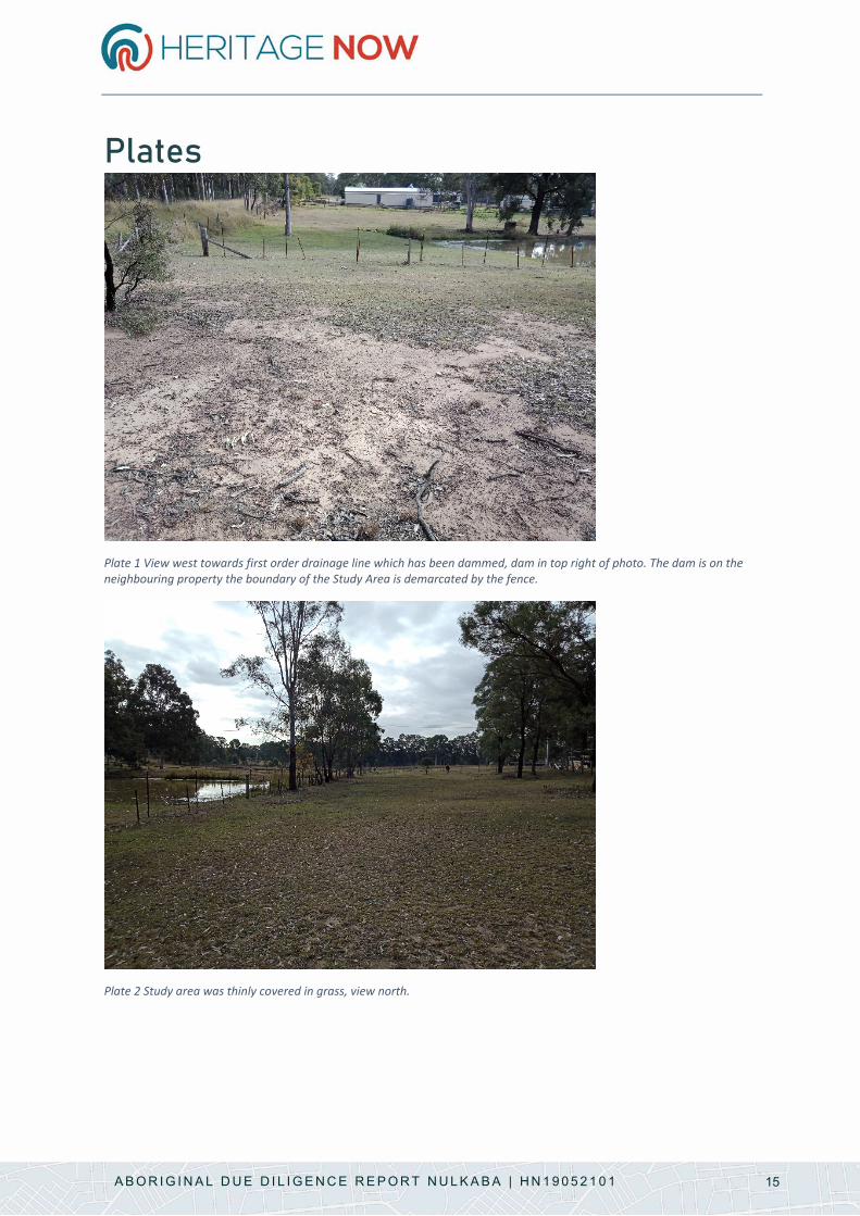
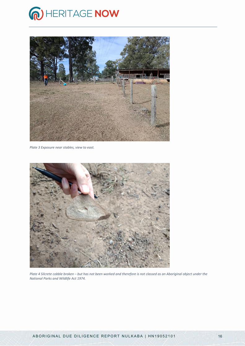
Site Visit The Study Area was inspected on Friday 7th June by Jason Brown (Mindaribba Local Aboriginal Land Council) and Tessa Boer-Mah (Heritage Now). The Study Area is located within 50m of a first order drainage line which has been dammed (on neighbouring property) (Plate 1). The Project Area was thinly covered in grass (Plate 2) with approximately 20% exposed ground near stables (Plate 3) and other areas subject to erosion. Overall visibility was approximately 30%.
Topsoils were A1 and B2 horizons in exposed areas (Plate 1 and Plate 3). There was no evidence for potential archaeological deposits in the Study Area.
No Aboriginal artefacts were identified. The area did contain silcrete cobbles (grey) with red/brown river cortex. These cobbles were broken, but had not been worked (Plate 4) and therefore are not classified as Aboriginal objects under the National Parks and Wildlife Act 1974.
Jason commented that overall the landscape was of cultural importance to Aboriginal people and that there are travelling stock routes and songlines in and around the Nulkaba area.
Summary Statement No Aboriginal sites, potential archaeological deposits or places were identified during the site visit.
A B O R I G I N A L D U E D I L I G E N C E R E P O R T N U L K A B A | H N 1 9 0 5 2 1 0 1
12
Impact Assessment The purpose of this due diligence assessment is first to identify whether there are Aboriginal objects or places present in the Study Area and/or whether there are specific Aboriginal cultural constraints on the Study Area. The second aim is to identify whether the proposed activity will impact the Aboriginal heritage identified.
The proposed activity is the rezoning of the Study Area from large lot residential (R5) to village (RU5) and thus will match zoning of the rest of Lot 1552, DP1046610.
Jason Brown from Mindaribba Local Aboriginal Land Council commented that overall the landscape was of cultural importance to Aboriginal people and that there are travelling stock routes and songlines in and around the Nulkaba area.
The results of the survey identified there were no Aboriginal objects or places under the National Parks and Wildlife Act 1974 are present in the Study Area.
This report has assessed Aboriginal heritage in the Study Area and has identified there are no heritage constraints to rezoning the heritage area. The proposed rezoning will not affect the heritage significance of the area. This report provides adequate assessment of the Study Area as per clause 5.10(8) of the Cessnock LEP and is consistent with the s117 direction.
A B O R I G I N A L D U E D I L I G E N C E R E P O R T N U L K A B A | H N 1 9 0 5 2 1 0 1
13
Conclusion This report has fulfilled the requirements under the Due Diligence Code of Practice for the Protection of Aboriginal Objects in NSW (OEH, formerly DECCW 2010). No Aboriginal objects, places or specific cultural areas were identified from the assessment of the Study Area.
This report has assessed Aboriginal heritage in the Study Area and has identified there are no heritage constraints to rezoning the heritage area. The proposed rezoning will not affect the heritage significance of the area. This report provides adequate assessment of the Study Area as per clause 5.10(8) of the Cessnock LEP and is consistent with the s117 direction.
Concluding Statement
There are no identified Aboriginal heritage constraints in relation to the rezoning of the Study Area.
A B O R I G I N A L D U E D I L I G E N C E R E P O R T N U L K A B A | H N 1 9 0 5 2 1 0 1
14
References Archaeological and Heritage Management Solutions. (c2005). Historical and Archaeological
Assessment of the former Aberdare Extended Colliery, Cessnock. AHIMS 102306: Report to Harper Somers O'Sullivan.
ERM. (2011). Cessnock Stages 1a and 1b Upgrades Hunter Water Stage 2 Heritage Assessment. Report to Hunter Water Corporation.
Geoscience Australia. (1972). Geological Map of New South Wales 1:1000000.
Keith, D. (2006). Ocean Shores to Desert Dunes: the Native Vegetation of New South Wales and the ACT. Hurstville: Department of Environment and Conservation.
McCardle Cultural Heritage. (2010). Faley Investigation Area: Indigenous Archaeological Due Diligence Assessment. AHIMS 102231: Report to ADW Johnson.
Minerals Council. (2010). NSW Minerals Industry Due Diligence Code of Practice for the Protection of Aboriginal Objects. Sydney: NSW Minerals Council.
NSW Soil and Land Information System. (2016). Soils Essentials Report: Profile 930.
OEH, formerly DECCW. (2010). Due Diligence Code of Practice for the Protection of Aboriginal Objects in NSW. Sydney: Department of Environment, Climate Change and Water.
Umwelt. (2011). Aboriginal Cultural Heritage and Archaeological Assessment: Stage 3 Modification, Austar Coal Mine Project. AHIMS 102381: Report to Austar Coal Mine.
A B O R I G I N A L D U E D I L I G E N C E R E P O R T N U L K A B A | H N 1 9 0 5 2 1 0 1
15
Plates
Plate 1 View west towards first order drainage line which has been dammed, dam in top right of photo. The dam is on the neighbouring property the boundary of the Study Area is demarcated by the fence.
Plate 2 Study area was thinly covered in grass, view north.
A B O R I G I N A L D U E D I L I G E N C E R E P O R T N U L K A B A | H N 1 9 0 5 2 1 0 1
16
Plate 3 Exposure near stables, view to east.
Plate 4 Silcrete cobble broken – but has not been worked and therefore is not classed as an Aboriginal object under the National Parks and Wildlife Act 1974.
A B O R I G I N A L D U E D I L I G E N C E R E P O R T N U L K A B A | H N 1 9 0 5 2 1 0 1
17
Acronyms and Definitions
Acronym Definition AHIMS Aboriginal Heritage Information Management System managed by OEH AHIP Aboriginal Heritage Impact Permit DECCW Department of Climate Change and Water, NSW, became the Office of
Environment and Heritage in 2011 GDA Geocentric Datum Australia km/s Kilometre/Kilometres LALC Local Aboriginal Land Council – Land Council under the Aboriginal Land Rights
Act 1983 LEP Local Environmental Plan LGA Local Government Area OEH Office of Environment and Heritage, NSW m Metric metres
A B O R I G I N A L D U E D I L I G E N C E R E P O R T N U L K A B A | H N 1 9 0 5 2 1 0 1
18
Attachment 1 AHIMS Search
AHIMS Web Services (AWS)Extensive search - Site list report
SiteID SiteName Datum Zone Easting Northing Context SiteFeatures SiteTypes Reports
Your Ref/PO Number : 19052101 Nulkaba
Client Service ID : 423173
Site Status
37-6-0993 BBAS1 AGD 56 343700 6364600 Open site Valid Artefact : - 98434,102381
1392,1976PermitsMrs.Angela BesantRecordersContact
37-6-0994 BBAS2 AGD 56 343200 6364100 Open site Valid Artefact : - 98434,102381
1392,1976PermitsMrs.Angela BesantRecordersContact
37-6-1722 OGC 5 GDA 56 344627 6366718 Open site Valid Artefact : 1
3142,3309,3353PermitsJim WheelerRecordersSearleContact
37-6-1723 OGC 6 GDA 56 344489 6366548 Open site Valid Artefact : 11
3142,3309,3353PermitsJim WheelerRecordersSearleContact
37-6-1724 OGC 7 GDA 56 344287 6367106 Open site Valid Artefact : 8, Potential
Archaeological
Deposit (PAD) : 2
3142,3309,3353PermitsJim WheelerRecordersSearleContact
37-6-1731 OGC 1 AGD 56 344200 6366790 Open site Valid Artefact : 1
3142,3309,3353PermitsExtent Heritage Pty Ltd - PyrmontRecordersT RussellContact
37-6-1732 OGC 2 AGD 56 344500 6366750 Open site Valid Artefact : 1, Potential
Archaeological
Deposit (PAD) : 2
3142,3309,3353PermitsExtent Heritage Pty Ltd - PyrmontRecordersT RussellContact
37-6-1733 OGC 3 AGD 56 344300 6366780 Open site Valid Artefact : 6
3142,3309,3353PermitsExtent Heritage Pty Ltd - PyrmontRecordersT RussellContact
37-6-1734 OGC 4 AGD 56 344420 6366790 Open site Valid Artefact : 1
3142,3309,3353PermitsExtent Heritage Pty Ltd - PyrmontRecordersT RussellContact
37-6-1372 Kitchener PAD 1 AGD 56 345875 6364500 Open site Valid Potential
Archaeological
Deposit (PAD) : -
102381
2129PermitsMs.Penny MccardleRecordersT RussellContact
37-6-1677 NB 1 GDA 56 342866 6363922 Open site Destroyed Artefact : 1
PermitsJim Wheeler,Extent Heritage Pty Ltd - PyrmontRecordersT RussellContact
37-6-1678 NB 2 GDA 56 342881 6363953 Open site Destroyed Artefact : 1
PermitsExtent Heritage Pty Ltd - Pyrmont,Mr.Allan WheelerRecordersT RussellContact
37-6-1679 NB 3 GDA 56 342899 6364049 Open site Destroyed Artefact : 1
PermitsExtent Heritage Pty Ltd - PyrmontRecordersT RussellContact
37-6-2276 Mount View Road AS01 GDA 56 344157 6366314 Open site Valid Artefact : 8 102362
3420PermitsERM Australia Pty Ltd- Sydney CBD,Ms.Holly MacleanRecordersContact
37-6-0948 C-IF-1 (Cessnock) AGD 56 346810 6367710 Open site Valid Artefact : - 4402,102381
PermitsMrs.Robynne MillsRecordersContact
Report generated by AHIMS Web Service on 27/05/2019 for Tessa Boer-Mah for the following area at Datum :GDA, Zone : 56, Eastings : 339756 - 349756, Northings : 6363110 - 6373110 with a
Buffer of 0 meters. Additional Info : heritage assessment. Number of Aboriginal sites and Aboriginal objects found is 88
This information is not guaranteed to be free from error omission. Office of Environment and Heritage (NSW) and its employees disclaim liability for any act done or omission made on the information and consequences of such
acts or omission.
Page 1 of 6
AHIMS Web Services (AWS)Extensive search - Site list report
SiteID SiteName Datum Zone Easting Northing Context SiteFeatures SiteTypes Reports
Your Ref/PO Number : 19052101 Nulkaba
Client Service ID : 423173
Site Status
37-6-3412 Site 3 143 O'Connors Rd Nulkab GDA 56 343812 6368326 Open site Deleted Artefact : -
PermitsMr.Giles HammRecordersContact
37-6-3413 Site 3 143 O'Connors Rd Nulkab; GDA 56 343812 6368326 Open site Valid Artefact : -
PermitsMr.Giles HammRecordersContact
37-6-3414 Site 1 143 O'Connors Road Nulkab GDA 56 343760 6368404 Open site Valid Artefact : -
PermitsMr.Giles HammRecordersContact
37-6-3552 Site 2 143 O'connor Rd Nulkaba AGD 56 344259 6368450 Open site Valid Artefact : -
PermitsMr.Giles HammRecordersContact
37-6-1216 Cessnock 2 AGD 56 347709 6367136 Open site Valid Artefact : - 102381
2977PermitsMCH - McCardle Cultural Heritage Pty LtdRecordersContact
37-6-1217 Cessnock 1 AGD 56 347691 6367126 Open site Valid Artefact : - 102381
2977PermitsMCH - McCardle Cultural Heritage Pty LtdRecordersContact
37-6-1386 HH 1 AGD 56 345835 6364588 Open site Valid Artefact : - 102381
2266PermitsMCH - McCardle Cultural Heritage Pty LtdRecordersS ScanlonContact
45-3-3360 Former Aberdare Extended Colliery GDA 56 345370 6364844 Open site Valid Artefact : 9 102306
PermitsHunter Land Pty LtdRecordersContact
37-6-1839 AR1_ GDA 56 345409 6367223 Open site Valid Artefact : 41
4395PermitsMs.Mary Dallas,Virtus Heritage ,Ms.Alison LamondRecordersContact
37-6-1987 OGC PAD 2 GDA 56 344423 6366624 Open site Valid Potential
Archaeological
Deposit (PAD) : 2,
Artefact : -
3142,3309,3353,4395PermitsJim Wheeler,Virtus Heritage ,Ms.Alison LamondRecordersContact
37-6-1988 OGC PAD 1 GDA 56 344423 6366624 Open site Valid Potential
Archaeological
Deposit (PAD) : 2
3142,3309,3353PermitsJim WheelerRecordersContact
37-6-1906 Hunter TEC Ironbark Lane 1 AGD 56 348171 6368361 Open site Valid Artefact : 100
PermitsMr.Roger MehrRecordersContact
37-6-2859 Reburial Site Mount View Road GDA 56 344189 6366286 Open site Valid Artefact : 1
PermitsHunter Water Corporation - Newcastle,Ms.Laura FarquharsonRecordersContact
37-6-3224 RPS North Bellbird 3 GDA 56 343227 6364233 Open site Valid Artefact : -
PermitsRPS Australia East Pty Ltd -HamiltonRecordersContact
37-6-3167 RPS North Bellbird 1 GDA 56 342978 6364618 Open site Valid Artefact : -
PermitsMs.Laraine NelsonRecordersContact
37-6-3168 RPS North Bellbird 2 GDA 56 342879 6363954 Open site Valid Artefact : -
Report generated by AHIMS Web Service on 27/05/2019 for Tessa Boer-Mah for the following area at Datum :GDA, Zone : 56, Eastings : 339756 - 349756, Northings : 6363110 - 6373110 with a
Buffer of 0 meters. Additional Info : heritage assessment. Number of Aboriginal sites and Aboriginal objects found is 88
This information is not guaranteed to be free from error omission. Office of Environment and Heritage (NSW) and its employees disclaim liability for any act done or omission made on the information and consequences of such
acts or omission.
Page 2 of 6
AHIMS Web Services (AWS)Extensive search - Site list report
SiteID SiteName Datum Zone Easting Northing Context SiteFeatures SiteTypes Reports
Your Ref/PO Number : 19052101 Nulkaba
Client Service ID : 423173
Site Status
PermitsMs.Laraine NelsonRecordersContact
37-6-0830 WP 18 (Cessnock) AGD 56 339800 6372595 Open site Destroyed Artefact : - Open Camp Site 4564,97875,98
174
1011,3713PermitsMichael Green,Mr.Benjamin StreatRecordersContact
37-6-0831 WP 19 AGD 56 342700 6372400 Open site Destroyed Artefact : - Open Camp Site 4564,97875,98
174
998PermitsMichael GreenRecordersContact
37-6-0686 Cessnock Landfill 1; AGD 56 349580 6367510 Open site Destroyed Artefact : - Isolated Find 3284,98174
PermitsMs.Jill Ruig,Ms.Nicole DavisRecordersContact
37-6-1040 Mt View 1 AGD 56 343500 6366076 Open site Valid Artefact : - 98434,102381
PermitsStedinger AssociatesRecordersContact
37-6-1041 Mt View 2 AGD 56 343610 6365958 Open site Valid Artefact : - 102381
PermitsStedinger AssociatesRecordersContact
37-6-1042 Mt View 3 AGD 56 343579 6366008 Open site Valid Artefact : - 98434,102381
PermitsStedinger AssociatesRecordersContact
37-6-1043 Mt View 4 AGD 56 343549 6365925 Open site Valid Artefact : - 98434,102381
PermitsStedinger AssociatesRecordersContact
37-6-1044 Mt View 5 AGD 56 343665 6366202 Open site Valid Artefact : - 98434,102231,
102381
PermitsStedinger AssociatesRecordersContact
37-6-1126 Mt View IF2 AGD 56 343430 6366410 Open site Valid Artefact : - 102381
1819PermitsStedinger AssociatesRecordersContact
37-6-1127 Mt View IF3 AGD 56 343387 6366140 Open site Destroyed Artefact : -
1819PermitsStedinger AssociatesRecordersContact
37-6-1675 LP 1 GDA 56 340384 6372621 Open site Valid Artefact : 1
PermitsJim Wheeler,Extent Heritage Pty Ltd - PyrmontRecordersT RussellContact
37-6-1676 LP 2 GDA 56 340231 6372727 Open site Valid Artefact : 1
PermitsJim Wheeler,Extent Heritage Pty Ltd - PyrmontRecordersT RussellContact
37-6-1680 NB 4 GDA 56 343324 6364239 Open site Destroyed Artefact : 1
PermitsJim Wheeler,Extent Heritage Pty Ltd - PyrmontRecordersT RussellContact
37-6-1681 NB 5 GDA 56 343683 6364658 Open site Destroyed Artefact : 1
PermitsJim Wheeler,Extent Heritage Pty Ltd - PyrmontRecordersT RussellContact
37-6-1682 NB 6 GDA 56 343700 6364681 Open site Valid Artefact : 1
PermitsJim Wheeler,Extent Heritage Pty Ltd - PyrmontRecordersT RussellContact
37-6-1683 NB 7 GDA 56 343770 6364763 Open site Valid Artefact : 1
PermitsJim Wheeler,Extent Heritage Pty Ltd - PyrmontRecordersT RussellContact
Report generated by AHIMS Web Service on 27/05/2019 for Tessa Boer-Mah for the following area at Datum :GDA, Zone : 56, Eastings : 339756 - 349756, Northings : 6363110 - 6373110 with a
Buffer of 0 meters. Additional Info : heritage assessment. Number of Aboriginal sites and Aboriginal objects found is 88
This information is not guaranteed to be free from error omission. Office of Environment and Heritage (NSW) and its employees disclaim liability for any act done or omission made on the information and consequences of such
acts or omission.
Page 3 of 6
AHIMS Web Services (AWS)Extensive search - Site list report
SiteID SiteName Datum Zone Easting Northing Context SiteFeatures SiteTypes Reports
Your Ref/PO Number : 19052101 Nulkaba
Client Service ID : 423173
Site Status
37-6-1684 NB 8 GDA 56 342216 6364064 Open site Valid Artefact : 1
PermitsJim Wheeler,Extent Heritage Pty Ltd - PyrmontRecordersT RussellContact
37-6-1685 NB 9 GDA 56 342134 6364619 Open site Valid Artefact : 1
PermitsJim Wheeler,Extent Heritage Pty Ltd - PyrmontRecordersT RussellContact
37-6-1686 NB 10 GDA 56 342099 6364573 Open site Valid Artefact : 100
PermitsJim Wheeler,Extent Heritage Pty Ltd - PyrmontRecordersT RussellContact
37-6-1687 NB 11 GDA 56 342059 6364574 Open site Valid Artefact : 1
PermitsJim Wheeler,Extent Heritage Pty Ltd - PyrmontRecordersT RussellContact
37-6-1688 NB 12 GDA 56 342030 6364503 Open site Valid Artefact : 1
PermitsJim Wheeler,Extent Heritage Pty Ltd - PyrmontRecordersT RussellContact
37-6-1689 NB 13 GDA 56 342002 6364466 Open site Valid Artefact : 1
PermitsJim Wheeler,Extent Heritage Pty Ltd - PyrmontRecordersT RussellContact
37-6-1690 NB 14 GDA 56 341555 6364229 Open site Valid Artefact : 1
PermitsJim Wheeler,Extent Heritage Pty Ltd - PyrmontRecordersT RussellContact
37-6-1691 NB 15 GDA 56 341770 6364444 Open site Valid Artefact : 1
PermitsJim Wheeler,Extent Heritage Pty Ltd - PyrmontRecordersT RussellContact
37-6-1692 NB 16 GDA 56 341901 6364543 Open site Valid Artefact : 1
PermitsJim Wheeler,Extent Heritage Pty Ltd - PyrmontRecordersT RussellContact
37-6-1693 NB 17 GDA 56 341934 6364156 Open site Valid Artefact : 1
PermitsJim Wheeler,Extent Heritage Pty Ltd - PyrmontRecordersT RussellContact
37-6-1694 NB 18 GDA 56 341901 6364142 Open site Valid Artefact : 1
PermitsJim Wheeler,Extent Heritage Pty Ltd - PyrmontRecordersT RussellContact
37-6-1695 NB 19 GDA 56 343602 6365415 Open site Valid Artefact : 1
PermitsExtent Heritage Pty Ltd - PyrmontRecordersT RussellContact
37-6-1696 NB 20 GDA 56 341586 6364124 Open site Valid Artefact : 1
PermitsJim Wheeler,Extent Heritage Pty Ltd - PyrmontRecordersT RussellContact
37-6-1697 NB 21 GDA 56 341391 6364894 Open site Valid Artefact : 3
PermitsJim Wheeler,Extent Heritage Pty Ltd - PyrmontRecordersT RussellContact
37-6-1698 NB 22 GDA 56 341320 6364838 Open site Valid Artefact : 1
PermitsJim Wheeler,Extent Heritage Pty Ltd - PyrmontRecordersT RussellContact
37-6-1456 Kerlew 1 AGD 56 344229 6367808 Open site Valid Artefact : 1
PermitsMrs.Angela BesantRecordersT RussellContact
37-6-1465 Hightrade 1 AGD 56 345700 6372300 Open site Valid Artefact : -
PermitsSouth East ArchaeologyRecordersT RussellContact
Report generated by AHIMS Web Service on 27/05/2019 for Tessa Boer-Mah for the following area at Datum :GDA, Zone : 56, Eastings : 339756 - 349756, Northings : 6363110 - 6373110 with a
Buffer of 0 meters. Additional Info : heritage assessment. Number of Aboriginal sites and Aboriginal objects found is 88
This information is not guaranteed to be free from error omission. Office of Environment and Heritage (NSW) and its employees disclaim liability for any act done or omission made on the information and consequences of such
acts or omission.
Page 4 of 6
AHIMS Web Services (AWS)Extensive search - Site list report
SiteID SiteName Datum Zone Easting Northing Context SiteFeatures SiteTypes Reports
Your Ref/PO Number : 19052101 Nulkaba
Client Service ID : 423173
Site Status
37-6-1699 NB23 GDA 56 341473 6364579 Open site Valid Artefact : 1
PermitsJim Wheeler,Extent Heritage Pty Ltd - PyrmontRecordersT RussellContact
37-6-1700 NB24 GDA 56 341235 6363989 Open site Valid Artefact : 1
PermitsJim Wheeler,Extent Heritage Pty Ltd - PyrmontRecordersT RussellContact
37-6-1701 NB25 GDA 56 341889 6364489 Open site Valid Artefact : 1
PermitsJim Wheeler,Extent Heritage Pty Ltd - PyrmontRecordersT RussellContact
37-6-2096 SPC 1 GDA 56 345916 6369449 Open site Valid Artefact : 1
4065PermitsMr.Rick BullersRecordersContact
37-6-2097 SPC 2 GDA 56 345845 6369387 Open site Valid Artefact : 16
4065PermitsMr.Rick BullersRecordersContact
37-6-2098 SPC 3 GDA 56 345866 6369451 Open site Valid Artefact : 1
4065PermitsMr.Rick BullersRecordersContact
37-6-2099 SPC 4 GDA 56 345740 6369512 Open site Valid Artefact : 2
4065PermitsMr.Rick BullersRecordersContact
37-6-2100 SPC 5 GDA 56 345589 6369385 Open site Valid Artefact : 10
4065PermitsMr.Rick BullersRecordersContact
37-6-2101 St Phillips PAD 1 GDA 56 345692 6369656 Open site Valid Potential
Archaeological
Deposit (PAD) : 1
4065PermitsMr.Rick BullersRecordersContact
37-6-2102 SPC 6 GDA 56 345577 6370065 Open site Not a Site Artefact : 1 102655
3417PermitsMr.John Appleton,Mr.Rick Bullers,Ms.Alexandra ByrneRecordersContact
37-6-2103 SPC7 GDA 56 345629 6369656 Open site Valid Artefact : 1
4065PermitsMr.Rick BullersRecordersContact
37-6-2104 SPC8 GDA 56 345692 6369586 Open site Valid Artefact : 15
4065PermitsMr.Rick BullersRecordersContact
37-6-2105 SPC9 GDA 56 345871 6369813 Open site Valid Artefact : 18
4065PermitsMr.Rick BullersRecordersContact
37-6-2106 SPC10 GDA 56 345877 6369879 Open site Valid Artefact : 10
4065PermitsMr.Rick BullersRecordersContact
37-6-2107 St Phillips PAD 2 GDA 56 345871 6369512 Open site Valid Potential
Archaeological
Deposit (PAD) : 1
4065PermitsMr.Rick BullersRecordersContact
Report generated by AHIMS Web Service on 27/05/2019 for Tessa Boer-Mah for the following area at Datum :GDA, Zone : 56, Eastings : 339756 - 349756, Northings : 6363110 - 6373110 with a
Buffer of 0 meters. Additional Info : heritage assessment. Number of Aboriginal sites and Aboriginal objects found is 88
This information is not guaranteed to be free from error omission. Office of Environment and Heritage (NSW) and its employees disclaim liability for any act done or omission made on the information and consequences of such
acts or omission.
Page 5 of 6
AHIMS Web Services (AWS)Extensive search - Site list report
SiteID SiteName Datum Zone Easting Northing Context SiteFeatures SiteTypes Reports
Your Ref/PO Number : 19052101 Nulkaba
Client Service ID : 423173
Site Status
37-6-2108 St Phillips PAD 3 GDA 56 345916 6369449 Open site Valid Potential
Archaeological
Deposit (PAD) : 1
4065PermitsMr.Rick BullersRecordersContact
37-6-2109 St Phillips PAD 4 GDA 56 345740 6369612 Open site Valid Potential
Archaeological
Deposit (PAD) : 1
4065PermitsMr.Rick BullersRecordersContact
37-6-3663 RPS Bellbird IS 1_2016 GDA 56 341923 6364708 Open site Valid Artefact : -
PermitsRPS Australia East Pty Ltd -Hamilton,Ms.Jo NelsonRecordersContact
37-6-3664 RPS Bellbird IS 2_2016 GDA 56 342898 6363983 Open site Valid Artefact : -
PermitsRPS Australia East Pty Ltd -Hamilton,Ms.Jo NelsonRecordersContact
37-6-3665 RPS Bellbird IS 3_2016 GDA 56 342028 6364528 Open site Valid Artefact : -
PermitsRPS Australia East Pty Ltd -Hamilton,Ms.Jo NelsonRecordersContact
37-6-3666 RPS Bellbird IS 4_2016 GDA 56 342028 6364528 Open site Valid Artefact : -
PermitsRPS Australia East Pty Ltd -Hamilton,Ms.Jo NelsonRecordersContact
37-6-3681 RPS Bellbird IS 3 GDA 56 342028 6364528 Open site Valid Artefact : -
PermitsRPS Australia East Pty Ltd -Hamilton,Ms.Jo NelsonRecordersContact
37-6-3682 RPS Bellbird IS 2 GDA 56 342898 6363983 Open site Valid Artefact : -
PermitsRPS Australia East Pty Ltd -Hamilton,Ms.Jo NelsonRecordersContact
37-6-3683 RPS Bellbird IS 1 GDA 56 341923 6364708 Open site Valid Artefact : -
PermitsRPS Australia East Pty Ltd -Hamilton,Ms.Jo NelsonRecordersContact
Report generated by AHIMS Web Service on 27/05/2019 for Tessa Boer-Mah for the following area at Datum :GDA, Zone : 56, Eastings : 339756 - 349756, Northings : 6363110 - 6373110 with a
Buffer of 0 meters. Additional Info : heritage assessment. Number of Aboriginal sites and Aboriginal objects found is 88
This information is not guaranteed to be free from error omission. Office of Environment and Heritage (NSW) and its employees disclaim liability for any act done or omission made on the information and consequences of such
acts or omission.
Page 6 of 6