a w a l k a b o u t t o w n ” - Barossa Council · “ a w a l k a b o u t t o w n ” Contents 1...
36
J e n s e n P l a n n i n g + D e s i g n H U B T r a f f i c & T r a n s p o r t A N G A S T O N U R B A N D E S I G N F R A M E W O R K “ a w a l k a b o u t t o w n ”
Transcript of a w a l k a b o u t t o w n ” - Barossa Council · “ a w a l k a b o u t t o w n ” Contents 1...

J e n s e n P l a n n i n g + D e s i g nH U B T r a f f i c & T r a n s p o r t
A N G A S T O N U R B A N D E S I G N F R A M E W O R K “ a w a l k a b o u t t o w n ”

A N G A S T O N U R B A N D E S I G N F R A M E W O R K “ a w a l k a b o u t t o w n ”
Contents 11.0 Background
1.1 Introduction To Project
1.2 History of Angaston
1.3 Town Character & Context
1.4 Current Barossa Development Plan Zoning
1.5 Objectives Of Report
2.0 Issues & Opportunities
2.1 Summary Of Consultation Process
2.2 Issues
2.3 Opportunities
2.4 Vision
3.0 Urban Design Framework
3.1 Introduction - A Walk About Town
3.2 Town Trail Network
3.3 Town Centre Pedestrian Links
3.4 Town Footpath Upgrades
3.5 Town Centre Urban Design Improvements
3.6 Town Centre Traffi c & Parking
3.7 Detailed Design
3.7.1 Angaston Railway Station Precinct
3.7.2 Town Hall Square
3.7.3 Village Green Precinct
3.7.4 Hannay Crescent Precinct
3.7.5 Murray Street Traffi c
3.7.6 Murray Street Streetscape Ideas
3.7.7 Murray Street Creek Crossing
J e n s e n P l a n n i n g + D e s i g nH U B T r a f f i c & T r a n s p o r t
August 2008
3.7.8 Murray Street Junction Upgrades
3.8 Materials Schedule
3.9 Planting Schedule
4.0 Implementation
4.1 Actions & Projects
4.2 Project Package Breakdown
4.3 Early Projects
4.4 Funding Opportunities
4.5 Links To Infrastructure Upgrades
4.6 Amendments To Development Plan
4.7 Conclusions & Acknowledgement
Appendices
1.0 References
2
2
2
2
2
2
4
4
5
7
9
10
10
11
13
15
17
19
21
21
22
23
24
25
26
27
28
29
30
31
31
32
32
33
34
34
34
35
35

A N G A S T O N U R B A N D E S I G N F R A M E W O R K “ a w a l k a b o u t t o w n ”
1.0 Background 21.1 Introduction To Project
Jensen Planning & Design along with Hub Traffi c and Transport were engaged by the Barossa Council in March 2008 to undertake an Urban Design Framework report for the town of Angaston in the Barossa Valley.
An urban design framework documents strategic design ideas or directions that can help Councils and other stakeholders plan for the future of their town or locality. The framework generally begins with broad strategic directions and fi lters these directions with input from stakeholders, the community and from the client to provide more tangible urban design solutions. Urban design frameworks also seek to capitalise and provide direction economic, environmental, social and cultural aspects of the locality.This framework was also driven by a design brief with strong environmental sustainability undertones, and the focus has been on movement, walking trails, pedestrian networks and cycling.
The Angaston Management Group has provided the consultants with an array of valuable information including their Business Plan and Strategic Plan. This information has provided the consultants with an insight into the perceived future of the town from a local community perspective.
A previous study of the town by Ian Barwick FAILA in 2003 recommended a streetscape upgrade for Murray Street and relatively minor design projects to enhance the quality of the town overall. This document has been a valuable resource for the main street details, and many of the ideas Ian Barwick suggested have been integrated into this report.
This urban design framework has been partly funded by the Government’s “Places For People” program for public space improvement strategies and projects. The program promotes principles of good urban design and the value of enhancing the quality and vitality of the urban environment.
1.2 History Of Angaston
Angaston began as a small settlement in the early 1840’s, and was known as German Pass. It developed into a thriving community known as Angas Town. Final proclaimation and lodgement of the town plan occurred in 1857 when the name Angaston was adopted. The naming is in honour of George Fife Angas (a signifi cant founding father of South Australia). The town was established by English then German migrants as a service village for the surrounding pastoral, orchard, and viticulture industries.The construction of Salters Bridge aided further development by improving the road link to Nuriootpa and beyond to Adelaide, and trade was further enhanced by the introduction of the railway in 1911.Since then, with the advent of wine based tourism, Angaston has established itself as an historic rural village not only servicing the Barossa Valley’s massive wine industry, but also servicing the mining and horticulture industries and hosting niche businesses such as the Barossa Valley Cheese Company and Angas Park Fruit.
1.3 Town Character & Context
Angaston is 77 kilometres north east of Adelaide and is one of several major towns that make up the Barossa Valley. The character and charm of Angaston is attributed directly to its German/ Lutheran beginnings. It has (more so than the other towns in the Valley) retained its rural village charm by preserving most of the original buildings in the town centre and has kept new development out of this historic area.
J e n s e n P l a n n i n g + D e s i g nH U B T r a f f i c & T r a n s p o r t
August 2008
Other elements such as the bends in Murray Street, the rural vistas from the town centre and the shady street trees add to the town’s unique quality which is distinctly different from the main streets of both Tanunda and Nuriootpa.Its location in low rolling hills on the eastern edge of the valley also creates a point of difference to the other towns, which have a relatively fl at topography. Nuriootpa has a far more ‘commercial’ feel to its main street than Angaston.
1.4 Current Barossa Development Plan Zoning
The majority of the town centre falls in the Town Centre Historic Conservation Zone (TCeH(C) Zone).The desired future character of this Zone as outlined in the Development Plan is:
“The Town Centre Historic (Conservation) Zone should remain the focus for retail, commercial, community, offi ce and civil functions which reinforce the unique character derived from the distinctive layout, mix of land uses, heritage buildings, post supported verandahs and deciduous trees.
Development should respect and enhance the existing pattern of development and the nineteenth and early twentieth century buildings and streetscapes.”
The Development Plan lists eight Objectives for this Zone. The following are the most relevant to this urban design framework study:
Objective 3:Conservation and reinforcement of the attractive historical character of land and buildings of considerable visual quality, as derived from the dominant Moreton Bay fi g trees along Murray Street and numerous buildings of architectural signifi cance including the Lutheran Church, Angaston Hotel, Masonic Hall, Old Post Offi ce, Barossa Hotel, National Bank, and Blacksmith’s Shop.
Objective 4: Retention of the pleasant visual appearance as derived from existing watercourses and associated vegetation.
Objective 6:To provide attractive streetscapes which reinforce the historic character and enhance the amenity of the Zone.
Objective 8:The area bounded by Washington Street, Sturt Street and Holmes Street retained as the civic focus of the town with associated community uses.
The Development Plan also outlines specifi c Conservation Guidelines for the Town Centre Historic Conservation Zone, these relate to:
• verandahs along Murray Street;• fi nishes and colour schemes of existing buildings;• advertising signs;• new buildings in Murray Street.
The Development Plan provides strong direction with regards to the perceived future visual amenity of the main street in particular. Elements relating to streetscape, the existing watercourses and buildings and trees of historical signifi cance have been incorporated into the ideas and design sketches presented in this urban design framework report.
Another large component of the town falls within the Residential Historic (Conservation) Zone (RH(C) Zone). The desired future character of this Zone is outlined in the Development Plan; it is predominantly based around the reinforcement of residential development as the primary use of the zone, and any new development should refl ect the existing architectural style of houses to maintain and enhance the distinctive character of the Zone.
The Development Plan also expresses the need for conservation and enhancement of the green spaces in this Zone:
“The signifi cant “green” area of the Angas Recreation Park should be retained as an important element within this residential area. Council should ensure all care is taken to retain this park in an appropriate manner, and it is recommended that a Management Plan be developed which ensures its future in the long term. The park between Dean Street and Hill Street and Angaston Children’s Reserve should also be retained as an open area for community use. The creek reserve should be further developed as a linear park.”
The relevant Objectives of this zone to this study include:
Objective 3:To conserve and complement existing historic buildings, including the use of appropriate landscape settings and traditional building elements, including fences, verandahs, balconies, hipped and gabled roofs.
Objective 5:Retention of the Angas Recreation Park, Angaston Children’s Reserve (now Angaston Memorial Reserve) and Hill Street Park as key community recreation areas serving Angaston.
The Development Plan provides excellent guidance to the future of Angaston’s many recreation reserves, and this guidance is consistent with the ideas and design sketches presented in ths report.A zoning map of Angaston has been produced and is shown opposite.
1.5 Objectives Of Report
It is anticipated that this urban design framework will serve two purposes. First, as the title suggests, it will provide a framework to guide Council in planning for new projects in a coordinated and strategic fashion.Second it can be used as a tool to submit to Government bodies for potential funding sources for individual projects targeted within the framework report.
The urban design framework report has the following overall objectives:
• create connections (signifi cant visual links and pedestrian ways) to open spaces, landmarks, creeks and places of interest;• develop a broader and better pedestrian / cycle network and a public lighting strategy to improve the quality of existing areas, public access and safety;• provide a safe and effi cient traffi c environment for local residents and tourists using all modes of transport, including motor vehicles, gophers, buses, cycling and walking;• identify elements for a master plan and design for capital works such as land use opportunities, streetscape upgrades, pathways, street furniture and interpretive signage;• develop an overall vision for the town based on consultation with the community, stakeholders and Council.

LEGEND
EIn = Extractive IndustryGIn = General Industry
LIn = Light IndustryR = Residential
RH(C) = Residential Historic (Conservation)Ru(BR) = Rural (Barossa Ranges)
Ru(HF) = Rural (Hills Face)RuL(1) = Rural Living (1)
Ru(VF) = Rural (Valley Floor)TCeH(C) = Town Centre Historic (Conservation)

A N G A S T O N U R B A N D E S I G N F R A M E W O R K “ a w a l k a b o u t t o w n ”
2.0 Issues & Opportunities 42.1 Summary Of Consultation Process
A two day workshop and community consultation process was held on 22nd and 23rd May 2008 at the Angaston Town Hall.
Titled “Community Open House” the event was broadly advertised in the Leader newspaper and provided an extended opportunity for members of the community to meet with the consultant team, contribute their ideas and take part in the process of shaping the urban design framework for the town.
The process began with a bus tour around the town with the project steering committee and the Angaston Management Group. This exercise identifi ed broader town-wide issues and opportunities for further exploration in the urban design framework.
An afternoon walk through the town centre followed. This walk was designed to investigate the function of Murray Street, specifi cally looking at vehicle and pedestrian movement in and around the town centre, commercial activity, and buildings of interest, as well as streetscape conditions and possibilities.
An evening workshop was conducted in the annexe of the Town Hall on the evening of the 22nd May. Key stakeholders were invited to take part in an informal brainstorming session with the consultants to gather and list issues and opportunities related to the function of the town.
On Friday the Town Hall doors were thrown open to the public between 9.30am and 4.30pm. Residents met with the consultants and again took part in the collection of issues and opportunites for the town.
A good turn-out of enthusiastic residents ensured that the consultant team had an understanding of a broad range of issues and desires of the Angaston community.
J e n s e n P l a n n i n g + D e s i g nH U B T r a f f i c & T r a n s p o r t
August 2008

A N G A S T O N U R B A N D E S I G N F R A M E W O R K “ a w a l k a b o u t t o w n ”
2.2 Issues 5The following issues have been identifi ed in consultation with the community, stakeholders and the Council.
The ideas represent a condensed list of the most commonly raised concerns relevant to this study.
Note this list is not in order of importance or priority. The numbers correspond with the Issues Map to show relative locations.
1. The Barossa Farmers Market is located out of town and is only accessible by road. There is an important need for a safe off road footpath / recreation trail. The narrow Salters Bridge is dangerous for pedestrians and cyclists.
2.The Angaston Train Station and railway line are in a state of disrepair and have no current use. There is a need to identify a new use for both the station and the railway land.
3.Memorial Park playgound area needs separation from Murray Street traffi c for the safety of children.
4.Facilities such as Angas Recreation Park (and the Barossa Farmers Market) are out of the town centre and aren’t sign posted; visitors may not be aware of their existence.
5.Underutilized land parcels on and behind Murray Street are vacant and may be available for development. Some unused sites are dilapidated.
6.The town turns its back on the creek which is hidden by businesses on Murray Street. Access to the Rose Repository behind the Village Green is poor and is an undiscovered/ underutilized asset.
7.The IGA Supermarket presents poorly to Murray Street and Sturt Street for such an important “landmark” site in the town.
8.Hannay Crescent (east lane) can get congested with parked cars and loading vehicle access confl icts. Pedestrian access to / through this area is poor.
9.Murray Street and Dean Street provide the only east - west access through the town centre. Additional access could occur to relieve Murray Street in busy periods, and during street closures.
J e n s e n P l a n n i n g + D e s i g nH U B T r a f f i c & T r a n s p o r t
August 2008
Hill Street provides the only vehicle exit from the hotel drive-through bottleshop; traffi c is forced to go west and “around the block” to get back to Murray Street as Hill Street is cut off by the creek.
10.Pedestrian access to the Child Care Centre on Valley Road is poor.
11.Heavy vehicles using Murray Street spoil the ambience and are dangerous for pedestrians trying to cross the road.
12.Lack of car parking on Murray Street.Some business employees sometimes use parking spaces to the detriment of customers and tourists. Parking at the rear of buildings on the south side of Murray Street is poorly utilized.
13.The linear park along the creek line is not well used and is not continuous through to the town centre.
14.Pedestrian access to the hospital on North Street is poor, and speed zone is 60kms per hour.
Other general issues raised included:
• It is important to maintain the country town “village” character of Angaston;• Lack of variety of tourist accommodation. There are now many Bed and Breakfast facilities, but no caravan park or high quality hotel accommodation;• Lack of a ‘home’ for community activities to cater for youth and the arts;• Lack of public transport to other towns in the Barossa Valley and into Adelaide;• Lack of pedestrian / cycle links between the Barossa Valley towns (Tanunda, Nuriootpa and Angaston);• Lack of parking for large vehicles (buses, motor homes and caravans);• Poor sight lines for vehicles entering Murray Street from side streets, especially close to bends where parked cars obscure views of oncoming traffi c;• Several vacant shops and a concern about a ‘lack of vitality’ on Murray Street;• Lack of sealed footpaths outside of Murray Street. This is of particular concern around facilities such as the hospital and schools;• Pedestrian links (such as the Shemmeld Lane pedestrian link over the creek) are unattractive and poorly signposted;• Poor signage throughout the town;• Poor lighting generally throughout the town.
Dilapidated and unused railway station and line
Old and tired looking street furniture
Inappropriate use of bus/ motor home parking spaces in Hannay Crescent. Lack of Council parking inspectors to police use

A N G A S T O N U R B A N D E S I G N F R A M E W O R K “ a w a l k a b o u t t o w n ”
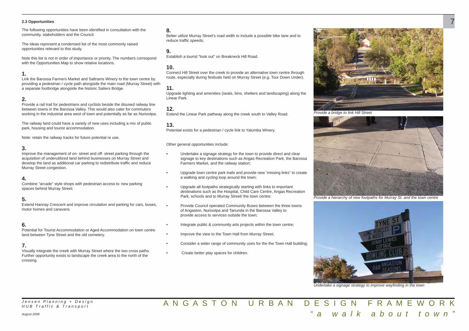
2.3 Opportunities
The following opportunities have been identifi ed in consultation with the community, stakeholders and the Council.
The ideas represent a condensed list of the most commonly raised opportunities relevant to this study.
Note this list is not in order of importance or priority. The numbers correspond with the Opportunities Map to show relative locations.
1.Link the Barossa Farmers Market and Saltrams Winery to the town centre by providing a pedestrian / cycle path alongside the main road (Murray Street) with a separate footbridge alongside the historic Salters Bridge.
2.Provide a rail trail for pedestrians and cyclists beside the disused railway line between towns in the Barossa Valley. This would also cater for commuters working in the industrial area west of town and potentially as far as Nuriootpa.
The railway land could have a variety of new uses including a mix of public park, housing and tourist accommodation.
Note: retain the railway tracks for future potential re use.
3.Improve the management of on- street and off- street parking through the acquisition of underutilized land behind businesses on Murray Street and develop the land as additional car parking to redistribute traffi c and reduce Murray Street congestion.
4.Combine “arcade” style shops with pedestrian access to new parking spaces behind Murray Street;
5.Extend Hannay Crescent and improve circulation and parking for cars, buses, motor homes and caravans.
6.Potential for Tourist Accommodation or Aged Accommodation on town centre land between Tyne Street and the old cemetery.
7.Visually integrate the creek with Murray Street where the two cross paths. Further opportunity exists to landscape the creek area to the north of the crossing.
J e n s e n P l a n n i n g + D e s i g nH U B T r a f f i c & T r a n s p o r t
August 2008
8.Better utilize Murray Street’s road width to include a possible bike lane and to reduce traffi c speeds;
9.Establish a tourist “look out” on Breakneck Hill Road.
10.Connect Hill Street over the creek to provide an alternative town centre through route, especially during festivals held on Murray Street (e.g. Tour Down Under).
11.Upgrade lighting and amenities (seats, bins, shelters and landscaping) along the Linear Park.
12.Extend the Linear Park pathway along the creek south to Valley Road.
13.Potential exists for a pedestrian / cycle link to Yalumba Winery.
Other general opportunities include:
• Undertake a signage strategy for the town to provide direct and clear signage to key destinations such as Angas Recreation Park, the Barossa Farmers Market, and the railway station;
• Upgrade town centre park trails and provide new “missing links” to create a walking and cycling loop around the town;
• Upgrade all footpaths strategically starting with links to important destinations such as the Hospital, Child Care Centre, Angas Recreation Park, schools and to Murray Street/ the town centre;
• Provide Council operated Community Buses between the three towns of Angaston, Nuriootpa and Tanunda in the Barossa Valley to provide access to services outside the town;
• Integrate public & community arts projects within the town centre; • Improve the view to the Town Hall from Murray Street;
• Consider a wider range of community uses for the the Town Hall building;
• Create better play spaces for children.
7
Provide a bridge to link Hill Street
Provide a hierarchy of new footpaths for Murray St. and the town centre
Undertake a signage strategy to improve wayfi nding in the town


A N G A S T O N U R B A N D E S I G N F R A M E W O R K “ a w a l k a b o u t t o w n ”
2.4 Vision
The identifi cation of issues and opportunities, along with the analysis of desired character statements for Angaston from the Development Plan have provided a broad but succinct design direction from which a vision statement for the town can be derived:
“Angaston is an historic, walkable township set in a rural landscape. It values, and shall maintain its people-focussed, village feel into the future”.
With the addition of ideas that promote town centre vitality, an active community and general townscape amenity, this statement encapsulates all of the urban design framework ideas presented in the next chapter of this report.
J e n s e n P l a n n i n g + D e s i g nH U B T r a f f i c & T r a n s p o r t
August 2008
9
Preferred character for Murray Street
Retain the compact form of the town
Maintain, upgrade and highlight historical buildings / elements in the town

A N G A S T O N U R B A N D E S I G N F R A M E W O R K “ a w a l k a b o u t t o w n ”
3.0 Urban Design Framework 103.1 Introduction - A Walk About Town
The following ideas are envisaged to uphold and reinforce the future vision for the town of Angaston.
The title “a walk about town” refl ects ideas associated with the key objective of safe and enjoyable movement in and around the town for pedestrians and cyclists. The urban design framework ideas presented are inherently based on the desire to create a walkable community by building and connecting places of interest and improving the experience along the way.
J e n s e n P l a n n i n g + D e s i g nH U B T r a f f i c & T r a n s p o r t
August 2008

A N G A S T O N U R B A N D E S I G N F R A M E W O R K “ a w a l k a b o u t t o w n ”
3.2 Town Trail Network 11The proposed trail network attempts to create a circuit around and through the town linking important facilities such as schools and the hospital with the town centre, while also providing a potential tourist circuit showcasing iconic buildings such as the Town Hall and tourist destinations such as the Village Green and Angas Recreation Park. The town trail network adds to and complements the broader footpath network of the town.
1.Vintners Bar and Grill
2.Barossa Farmers Market
3.Industry
4.Possible “rail trail” to Nuriootpa through industrial area
5.Saltrams Winery
6.Possible trail to Farmers Market and to Nuriootpa in road verge
7.Historic Salters Bridge
8.Possible tourist lookout at end of Fife Street
9.Railway Station building
10.Possible open space / public access on railway land
11.Town circuit to incorporate Memorial Reserve and playgound
12.Town circuit to run under Penrice Road Bridge
13.Link to Old Union Chapel
J e n s e n P l a n n i n g + D e s i g nH U B T r a f f i c & T r a n s p o r t
August 2008
14.Town circuit to run past Angaston Town Hall
15.Town circuit to run through Angas Recreation Park
16.Possible tourist lookout on Breakneck Hill Road
17.Town circuit to incorporate the Village Green and Rose Repository
18.Town circuit to incorporate the Old Cemetery
19.Town circuit to incorporate the Old Mill
20.Town circuit to incorporate Murray Street town centre facilities
21.Town circuit to link schools/ child care facility with town centre
22.Town link to run past existing park and playground
23.Scouts/ Ambulance Service location
24.Angas Park Fruit Company
25.Angaston Hospital
26.SA Company Store
27.Link to Yalumba Winery
Indicative sketch of proposed pedestrian bridge beside Salters Bridge


A N G A S T O N U R B A N D E S I G N F R A M E W O R K “ a w a l k a b o u t t o w n ”
3.3 Town Centre Pedestrian Links
An improvement in town centre footpaths and linkages, along with new amenities such as signage and street furniture, will entice locals and tourists to leave their cars and walk around the town. This will increase opportunistic shopping on Murray Street and will improve access and appreciation of several town centre places such as the railway station, the creek and the rose repository gardens.
1.Existing footpaths / recreational trails.
2.Provide new recreation trail along creek edge, and complete path link up to Penrice Road.
3.Possible rail trail exit point on to Washington Street
4.Possible car park space behind hotel.
5.Provide trail link under Penrice Road bridge.
6.Provide new and consistent high quality footpath treatment to Murray Street.
7.New / improved footpath links from proposed future car parking areas to Murray Street.
8.Proposed future / improved car parking areas with signage.
9.Provide footbridge over creek linking Rose Repository to Village Green, and continuous path to meet creek recreation trail.
10.New improved footpath link from upgraded car park / recreation trail to Murray Street.
11.Upgrade car park on Hannay Crescent
12.Possible new footpath / recreation trail link to Newcastle Street through easement.
J e n s e n P l a n n i n g + D e s i g nH U B T r a f f i c & T r a n s p o r t
August 2008
13.New improved footpath link from upgraded car park to Murray Street.
14.Vacant land could possibly be used for new town centre uses.
15.Possible bus/ motor home parking location.
16.New improved footpath link from proposed bus / motor home parking to Murray Street.
17.Possible new footpath / recreation trail link from Murray Street along creek edge to footpath link with Hill Street.
18.Improve Shemmeld Lane appearance with new paving, lighting and directional signage to Linear Park recreation trail.
19.New footpath / recreation trail link between Dean Street and Hill Street with fl atter grades and more direct connection to the Linear Park trail.
20.Possible alternative new footpath / recreation trail link between Dean Street and Hill Street. Possible right of way through private land.
21.New pedestrian (and road) link over the creek to join Hill Street east and west.
13
Shemmeld Lane could be upgraded to provide better pedestrian access
Typical example of a pedestrian bridge in Rymill Park Adelaide
Extend Linear Park recreation trail along creek in Angaston


A N G A S T O N U R B A N D E S I G N F R A M E W O R K “ a w a l k a b o u t t o w n ”
3.4 Town Footpath Upgrades
Upgrading footpaths in the town of Angaston will encourage people to walk rather than drive and will alleviate car parking and traffi c issues on Murray Street. It will further improve the walking experience for both residents and visitors to the town, as well as promoting a healthier community.
The provision of upgraded footpaths will increase pedestrian safety and amenity, and an appropriate hierarchy of footpath materials will reinforce the importance of Murray Street as the main street of the town.
1.Murray StreetImprove footpath with high quality unit pavers from North Street to Memorial Park on the north side and to West Terrace on the south side.Minimum width = provide paving from property boundary to back of kerb.Appropriate materials = large format unit pavers or unit paver header courses and bands with concrete or bitumen infi ll.
2. Secondary FootpathsProvide new / upgrade existing footpaths that provide strategic access to important destinations such as Murray Street, Angas Recreation Park, schools, the hospital and the child care centre.Minimum width = 1.5mAppropriate materials = bitumen or concrete
3.Tertiary FootpathsProvide new / upgrade existing footpaths to provide safe off- road pedestrian movement into the town centre.Desirable width = 1.5m, minimum width = 1.2mAppropriate materials = compacted crushed rock or gravel
J e n s e n P l a n n i n g + D e s i g nH U B T r a f f i c & T r a n s p o r t
August 2008
15
Unit pavers with contrasting banding and header course in Adelaide.
Bitumen paving with contrasting banding and header course in Adelaide.
Compacted quarry rubble footpath with steel edging in Adelaide.


A N G A S T O N U R B A N D E S I G N F R A M E W O R K “ a w a l k a b o u t t o w n ”
3.5 Town Centre Urban Design Improvements
Improving and upgrading the town centre of Angaston could prove to be a catalyst for economic development in the main street. New footpaths and better amenities such as street furniture and signage will instil a sense of civic pride amongst residents and will help to attract tourists to stop and spend time (and money) in the town centre.
Several areas have been identifi ed for possible new development or improvement. These may require further detailed design studies, and can be developed as individual projects in the future.
1.Possible upgrade and relocation of playground in Memorial Park.Provide landscaping beside path edge to enclose playground and park and provide a visual buffer from road edge.
2. Link path over creek to Penrice Road and creek trail.Provide footpath / recreation links along creek and to Penrice Road.Provide directional signage to destinations (such as the Union Chapel on Penrice Road)
3.Potential development of railway land as a public reserve or tourist accommodation (caravan park/ cabins/ camping) with recreation trails linking town centre with proposed rail trail. (See 3.7.1)
4.Potential development or upgrade of land behind businesses on Murray Street for car parking to supplement Murray Street car parking. Negotiate with land owners to better manage under-utilised car parking areas behind Murray Street.
Support the proposed redevelopment of the Hotel on the corner of Sturt Street and Murray Street by recommending development of railway land for car parking in accordance with Council requirements and retention of heritage stone wall.
5.Provide architecturally sensitive infi ll buildings in Murray Street on current vacant lots and / or vacant and dilapidated buildings. There is opportunity for arcade style shops and pedestrian links through to new proposed car parking.
6.Potential development of land for bus / motor home parking.
7.Potential upgrade of Murray Street footpath with high quality unit pavers from North Street to Memorial Park on north side and to West Tce. on the south side.Provide new street furniture (bins, seats, bollards, lights) to improve the aesthetics of Murray Street and to provide a consistent theme for the whole street. (See 3.7.6)
J e n s e n P l a n n i n g + D e s i g nH U B T r a f f i c & T r a n s p o r t
August 2008
8.Remove parking from forecourt of Town Hall and provide new landscaping with paving, seating and lighting to enhance the Town Hall building. (See 3.7.2)
9.At the Village Green, remove all car parking and provide new landscaping and street furniture for visitors.Construct a footbridge to link the Village Green with the Rose Repository garden forming one large recreation space. (See 3.7.3)
10.Vacant land between Tyne Street and old Cemetery could possibly be used for new town centre uses. Ideas could include: Bowls Club relocation and land swap, or tourist accommodation in association with Old Mill upgrade.There is also potential for new town centre uses behind the church on Hill Street.(See 3.7.4)
11.Potential redevelopment of Old Mill as a tourist destination incorporating a possible conference centre with restaurant and art gallery/ museum.
12.At the creek crossing on Murray Street highlight the presence of the creek with new bridge balustrading and a different paving material on the roadway. Maintain the rural vista from the bridge north to the surrounding hills. (See 3.7.7)
13.Provide a boardwalk link along the western edge of the creek between Murray Street and the CWA that links to the pedestrian bridge over the creek to Hill Street. This will open up a pedestrian vista to the south of the town and improve access to car parking near the CWA.
14.Provide new landscaping to the Linear Park and creek edge.
17
New street furniture including bike rails should be installed on Murray St.
Remove car parking and provide more street furniture in Village Green
Typical example of open style balustrade for use on Murray Street to improve the visibility of the creek


A N G A S T O N U R B A N D E S I G N F R A M E W O R K “ a w a l k a b o u t t o w n ”
3.6 Town Centre Traffi c & Parking
Improving vehicle movement through the town (including road access and parking) will provide more convenient access options for town centre traffi c, and improve safety and legibility for road users and pedestrians. These improvements will be supplemented by a signage strategy to improve wayfi nding in the town, including to off-street car parking.
1.Provide for car parking behind the hotel in railway land with access from Kent Street. Retain the heritage stone wall and railway tracks, and provide perimeter landscaping to improve the aesthetics of the area.
2.Remove all car parking from the Town Hall forecourt and provide new landscaping to improve aesthetics. (See 3.7.2)
3.Review junction design at Sturt Street, Washington Street and Kent Street intersection and integrate with proposed upgraded car park access behind the IGA and the Hotel.
4.Remove car park access from Murray Street and provide new in and out lanes onto Sturt Street and Hill Street.
5.Improve sight lines at road junctions with protuberences and extended stop lines. (See 3.7.8)
6.Potential pedestrian access to Murray Street from car park areas.
7.Provide for upgraded car parking and improved / integrated management of car parking behind businesses on Murray Street and integrate with existing parking and access points.
8.Hannay Crescent; one way access (in only) to alleviate traffi c and pedestrian confl icts.
9.Retain existing one way access to drive- through bottle shop and car park at rear of business.
10.Possible new road link / loop for improved access to parking and bus/ motor home parking behind the Old Mill.
J e n s e n P l a n n i n g + D e s i g nH U B T r a f f i c & T r a n s p o r t
August 2008
11.Encourage the use of bikes through the creation of linemarked cycle lanes on Murray Street to provide a protected passage for cyclists, encourage low traffi c speed by visually narrowing the traffi c lanes, and provide an area for safe loading and unloading of cars.Provide bike parking rails on Murray Street, and at other important destinations around the town. (See 3.7.5)
12.Possible bus/ motor home parking location.
13.Upgrade vehicular access to land (potential car park) behind Blacksmith’s shop.
14.Link Hill Street East and Hill Street West to provide a convenient alternative route through the town centre, and to provide alternative access points to new / upgraded car parking areas.
19


A N G A S T O N U R B A N D E S I G N F R A M E W O R K “ a w a l k a b o u t t o w n ”
3.7 Detailed Design
The Consultant Team has selected a number of sites for further detailed analysis and concept design ideas. These are by no means fi nal design solutions but offer a visual cue as to what possibilities could be relevant for each site.
3.7.1 Angaston Railway Station Precinct
The railway land between Kent Street and Fife Street is currently unused and poorly maintained and the Angaston station building is falling into disrepair.
Being in such a valuable location close to the town centre the land has great potential for town centre-related or tourism uses.
Some of the land behind the Hotel has potential for parking associated with the Hotel’s planned upgrade. Other areas have the potential for alternative uses including:
• a public park with recreational trail extending along the railway line to Nuriootpa;
• possible tourist accommodation such as cabins or a small caravan park;
• residential lots at the western end of Fife Street where there are some existing houses.
Public access to the rail corridor with a trail and improved maintenance would create a valuable asset for the town as a new recreational experience. It would also allow an appreciation of the historic station building for visitors, and the added surveillance would help in the protection of the building from vandalism.
J e n s e n P l a n n i n g + D e s i g nH U B T r a f f i c & T r a n s p o r t
August 2008
21
The stone wall at the eastern end of Kent Street should be retained, with some tree clearing associated with the possible car park development to allow views over the wall for better car park security.
The potential trail links into Washington Street at the Town Hall Square precinct and is already an attractive sheltered walk in the railway land with trees along the southern side of the existing access track.

A N G A S T O N U R B A N D E S I G N F R A M E W O R K “ a w a l k a b o u t t o w n ”
3.7.2 Town Hall Square
The Town Hall is an attractive grand building on a prominent road junction, visible from the main street and a place for community activity.
The forecourt is currently a bland paved area used mainly for car parking, but has the potential to be an attractive civic space with landscaping, seating and paved areas for access to the building. The north- facing forecourt has potential for a commercial use such as a cafe or restaurant with outdoor dining capabilities.
Car parking should be relocated to the rear of the building where there is adequate space, subject to further traffi c management studies to identify parking needs and possible road closures.
The existing utilitarian roadside signage occupies “centre stage” and spoils the view of the Town Hall facade. Improvements to signage design and possible relocation would also help beautify the forecourt.
New planting and paving should aim to reinforce the vista down to Murray Street and “frame” the building when seen from its Sturt Street approach.
J e n s e n P l a n n i n g + D e s i g nH U B T r a f f i c & T r a n s p o r t
August 2008
22
An indicative treatment for the Angaston Town Hall forecourt

A N G A S T O N U R B A N D E S I G N F R A M E W O R K “ a w a l k a b o u t t o w n ”
3.7.3 Village Green Precinct
The Village Green is an important and attractive public space in the heart of the main street, and functions as a respite space for visitors and residents as well as for the occasional festival.
Part of the space is paved and is used as main street parking (approximately ten spaces) except during functions.
Suggestions for the improvement of the Village Green include:
• removing the car parks permanently to increase the open space, encourage better use and improve its appearance; the proposed increase in spaces in Hannay Crescent (3.7.4) should occur prior to this project to offset the loss of these car parking spaces;• relocating disabled car parking spaces to Hannay Crescent for better proximity to the pharmacy and doctors’ surgery;• improve the facilities in the space with more tables and benches, possible barbecues, bocce pitch;• investigate the relocation of the large transformer in the arbor to a less visible location away from this feature;• build a new pedestrian bridge over the creek to increase the open space and “connect and include” the Rose Repository gardens as part of the Village Green;• create a footpath link between the new footbridge and the creek trail.
J e n s e n P l a n n i n g + D e s i g nH U B T r a f f i c & T r a n s p o r t
August 2008
23

A N G A S T O N U R B A N D E S I G N F R A M E W O R K “ a w a l k a b o u t t o w n ”
3.7.4 Hannay Crescent Precinct
Hannay Crescent currently provides access for limited car and bus parking at the rear of Murray Street business premises, including the doctors’ surgery. It also provides access for cars and pedestrians to the Rose Repository garden and the cemetery. Vehicle access is primarily from the western “lane”, while access from the eastern lane is problematic: it is narrow, with confl icts between parked cars and a loading space, and has limited sight distance being close to a bend in Murray Street.
Ideas for redevelopment of the area include:
• a possible road link to Tyne Street to provide a road “loop” with better access to Murray Street and improved bus access and parking;• potential to create a more effi cient car parking area with an increased number of spaces for Murray Street users;• a one-way only entry at the Hannay Crescent eastern “lane” to simplify movements at Murray Street and provide space to use for improved pedestrian access.
The existing Newcastle Street road reserve link into Hannay Crescent is currently not used, but provides access to a couple of properties on the northern side. This also has potential as a road link, but is seen as less desirable as it would disturb the quiet ambience behind the cemetery. However, with the likely future development of the existing vacant Bowling Club and Council land, Newcastle Street could become a dedicated pedestrian linkage between the Village Green and the primary school.
J e n s e n P l a n n i n g + D e s i g nH U B T r a f f i c & T r a n s p o r t
August 2008
24

A N G A S T O N U R B A N D E S I G N F R A M E W O R K “ a w a l k a b o u t t o w n ”
3.7.5 Murray Street Traffi c
Suggested modifi cations to Murray Street include new linemarking to narrow the road travel lanes, the introduction of marked cycle lanes and paved protuberances at junctions to improve the visibility of approaching main street traffi c.
At present the main street is a simple arrangement of two travel lanes and parallel parking on both sides. The parking lanes are wider than necessary, and many residents have commented about the speed of some vehicles in a shopping street environment.
Travel LanesThe narrowing of travel lanes will:• visually narrow the roadway to help reduce traffi c speed; and• reduce the distance across the travel lanes to provide safer pedestrian crossing.
Narrowing the parking space width to 2.17 metres, combined with narrower travel lanes will create the space for cycle lanes to allow for safer bike movement and encourage cycling in the town.
The cycle lane also creates a “refuge” space for pedestrians waiting to cross, and allows some leeway in the road when two large vehicles are passing each other.
“T” marks to defi ne parking spaces avoid the need for two solid lines on each side which would be visually detrimental.
J e n s e n P l a n n i n g + D e s i g nH U B T r a f f i c & T r a n s p o r t
August 2008
25
Proposed line marking treatment for Murray Street

A N G A S T O N U R B A N D E S I G N F R A M E W O R K “ a w a l k a b o u t t o w n ”
3.7.6 Murray Street Streetscape Ideas
Murray Street is Angaston’s shopping street, its community “heart” and main tourist attraction. It has an informal “country town” feel, lined by many historic buildings and with an attractive, consistent rhythm of built form.
The downhill journey from east to west and the subtle bends in the road add mystery and interest through changing perspectives to the experience of the town centre.
The wooded landscape beyond the main street is always evident, and tree planting, although inconsistent, provides shade and creates a leafy character.
On closer inspection, however, Murray Street is let down by poor, inconsistent footpath treatments and street furniture, including dated rubbish bins and casual ‘ad hoc’ placement of planter tubs, seating, signage and lighting.
A detailed streetscape upgrade is required which could dramatically improve the appearance of Murray Street, especially the experience for pedestrians. This, along with other town centre initiatives, will have the potential to boost tourism in Angaston and revitalise business and town centre activity.
J e n s e n P l a n n i n g + D e s i g nH U B T r a f f i c & T r a n s p o r t
August 2008
26Some ideas for streetscape improvements include the following:
• create “gateways” at each end of Murray Street to signal the arrival at the town centre through signage, landscaping and possible road paving treatments;
• retain a consistent scale and complementary style for new infi ll buildings to retain its low scale village character;
• provide new paving treatments which defi ne clear areas for walking, while also designating areas for planting, seating, rubbish bins and lights. This can be done by introducing bands of unit pavers to provide visual boundaries and interest (shades of grey are in keeping with the existing character);
• provide street furniture and lighting with a consistent style and colour;
• identify appropriate places for seating;
• develop a signage strategy for the main street as part of a “whole of township” approach;
• introduce an outdoor dining and signage policy for Murray Street to provide guidelines on the use of A frame signs and location / size of outdoor dining tables to prevent footpath obstacles;
• review the design of the existing pedestrian crossing and install a more attractive solution, in keeping with footpath paving themes and incorporating landscaping to soften the design;
• undertake a street tree audit to identify the various different types of street trees planted on Murray Street. Provide a future street tree planting strategy to plant a consistent species to unify the whole street. This could be undertaken in a staged removal and replanting project over a number of years, or could occur as needed as older species die and need replacing;
• provide additional maintenance to the historically signifi cant Moreton Bay fi g trees to clean up fruit drop. Employ an arborist to investigate any limb removal or cutting of buttress roots to improve pedestrian safety.
Proposed simple paving band treatment for Murray Street to delineate footpath traffi c clearway

A N G A S T O N U R B A N D E S I G N F R A M E W O R K “ a w a l k a b o u t t o w n ”
3.7.7 Murray Street Creek Crossing
The Angaston Creek runs under Murray Street about halfway between the gateways to the town centre. At present the creek is not really noticed or appreciated. Public access is not possible, although the view from the bridge to the town’s rural backdrop to the north is valued.
To recognise the existence of the creek it is suggested that a special road and footpath treatment be provided, along with new bridge balustrades to signal one’s “arrival” at the creek and to create a special place with signage in the centre of Angaston’s main street. Car parking in front of the creek on Murray Street should be removed to help enhance the sense of arrival and open up vistas along the creek to motorists, cyclists and pedestrians.
There is also potential to provide pedestrian access to the creek on the south side via a boardwalk linking through to the trail and car parking near the CWA.
The vista to the north needs to be protected, with the potential for planting and possibly a small weir and pond (subject to creek fl ooding assessment).
J e n s e n P l a n n i n g + D e s i g nH U B T r a f f i c & T r a n s p o r t
August 2008
27
Possible new bridge treatment and creek boardwalk

A N G A S T O N U R B A N D E S I G N F R A M E W O R K “ a w a l k a b o u t t o w n ”
3.7.8 Murray Street Junction Upgrades
Parked cars and the bends in Murray Street currently reduce the sight distance and visibility to oncoming cars for vehicles waiting to enter from side streets.
The introduction of pavement level protuberances (paved inserts) and new stop lines will improve sight distances for safer vehicle entry, especially for those wishing to turn right. The protuberances also provide a pedestrian refuge for safer crossing at junctions.
Pavers such as dark grey granite “setts” are envisaged, to be in keeping with a country town main street, not a suburban style raised platform treatment. Simple bollards will help defi ne and protect the protuberance refuge.
J e n s e n P l a n n i n g + D e s i g nH U B T r a f f i c & T r a n s p o r t
August 2008
28
Current scenario - obscured sight lines at junctions
Proposed solution provides a clearer view of oncoming traffi c

A N G A S T O N U R B A N D E S I G N F R A M E W O R K “ a w a l k a b o u t t o w n ”
3.8 Materials Schedule
J e n s e n P l a n n i n g + D e s i g nH U B T r a f f i c & T r a n s p o r t
August 2008
29Carefully selected paving materials and street furniture are important elements in uniting a street or town centre as they introduce consistent themes of colour, texture, form and pattern.
Paving bands and header courses introduce a rhythm to the street and can act to delineate pedestrian and other spaces.
Granite setts break up large paved spaces and can be used to pave protuberances.
Street furniture should be complementary to the paving material and furniture items should complement each other in materials, texture and form.
Bollards and bike rails act to separate pedestrian and vehicular spaces while introducing a vertical rhythm and adding architectural interest to the street.
Granite Setts
Bicycle Rails Bin Enclosure (Street & Park Furniture)
Grindle Seat (Street & Park Furniture) Hardwood timber bollards with galvanised steel caps
Bitumen paving with unit paver bands and headercourse

A N G A S T O N U R B A N D E S I G N F R A M E W O R K “ a w a l k a b o u t t o w n ”
3.9 Planting Schedule
J e n s e n P l a n n i n g + D e s i g nH U B T r a f f i c & T r a n s p o r t
August 2008
30New planting should complement the existing planting palette while being suitable for the climate and character of Angaston.
New street tree planting on Murray Street should be of one species to provide consistency and unify the street as a whole. There are currently more than three different species planted along Murray Street including; Jacaranda (Jacaranda Mimosifolia), Plane tree (Platanus orientalis), White Cedar (Melia azedarach), English Elm (Ulmus procera) and Moreton Bay Fig (Ficus macrophylla).
Away from the main street, street tree planting is varied with species including; Jacaranda (Jacaranda mimosifolia), Ash (Fraxinus sp.) and many forms of small Gum trees (Eucalyptus sp.).
Street tree planting away from Murray Street should refl ect the hierarchy of the street, with larger, grander trees lining collector roads such as Sturt Street, Washington Street, North Street, Moculta Road and Penrice Road. Smaller more compact trees should be planted to local streets such as Dean Street, Hill Street, Evans Street and Fife Street.
Native and endemic street trees are recommended for all street trees except Murray Street to reinforce the European character of Murray Street and to contrast with the surrounding town. Species such as the River Red Gum (Eucalyptus camaldulensis) and Sugar Gum (Eucalyptus cladocalyx) should be considered for wider street verges, while Euky Dwarf (Eucalyptus leucoxylon dwarf) and the Pink Gum (Eucalyptus fasciculosa) should be considered for local narrow residential streets.
Similarly, native and endemic plant species are recommended for planting in parks, verges and along the creekline.
It is envisaged that the planter boxes on Murray Street should be planted to reinforce the European character of the town- this should be undertaken to the discretion of shop owners and volunteers who maintain them.
Street Trees (Murray Street)
• Jacaranda (Jacaranda mimosifolia)• Plane Tree (Platanus orientalis)
Street Trees (Collector Roads)
• River Red Gum (Eucalyptus camaldulensis)• SA Blue Gum (Eucalyptus leucoxylon)• Sugar Gum (Eucalyptus cladocalyx)
Street Trees (Local Streets)
• Coral Gum (Eucalyptus torquata)• Euky Dwarf (Eucalyptus leucoxylon dwarf)• Mallee Box (Eucalyptus porosa)• Pink Gum (Eucalyptus fasciculosa)• Red Mallee (Eucalyptus socialis)
Other Trees (Parks and Gardens)
• Drooping Sheoak (Allocasuarina verticillata)• Golden Wattle (Acacia pycnantha)• Native Apricot (Pittosporum phylliraeoides)• River Red Gum (Eucalyptus camaldulensis)• SA Blue Gum (Eucalyptus leucoxylon)• Silver Banksia (Banksia marginata)• Southern Cypress Pine (Callitris preissii)• Sugar Gum (Eucalyptus cladocalyx)
Other Trees (Creekline Planting)
• River Box (Eucalyptus largifl orens)• River Red Gum (Eucalyptus camaldulensis)
Shrubs
• Clasping Goodenia (Goodenia amplexans)• Common Emu Bush (Eremophila glabra) • Gold Dust Wattle (Acacia acinaceae)• Lavender Grevillea (Grevillea lavandulacaea) • Lignum (Muehlenbeckia cunninghamii)• River Bottlebrush (Callistemon seiberi)• Rock Correa (Correa glabra)• Running Postman (Kennedia prostrata)• Sticky Hop- bush (Dodonaea viscosa)• Sweet Bursaria (Bursaria spinosa)
Groundcovers
• Berry Saltbush (Atriplex semibaccata)• Climbing Saltbush (Einada nutans)• Creeping Boobialla (Myoporum parvifolium)• Muntries (Kunzea prostrata)• Native Lilac (Hardenbergia violacea)• New Holland Daisies (Vittadinia sp.)• Pigface (Carpobrotus rossi)• Round Leaf Pigface (Disphyma crassifolium)• Variable Groundsel (Senecio lautus)
Grasses/ Sedges
• Black - Anther Flax Lily (Dianella revoluta)• Black Heads (Enneapogan nigricans)• Giant Liriope (Liriope Evergreen Giant)• Hard Mat - Rush (Lomardra longifolia)• Kangaroo Grass (Themeda triandra)• Native Flax (Linum marginale)• Smallfl ower Wallaby Grass (Austrodanthonia setacea)• Tasman Flax Lily (Dianella tasmanica)
Eucalyptus fasciculosa (fl ower)
Hardenbergia violacea
Grevillea lavandulacea
Dianella revoluta Jacaranda mimosifolia
Eucalyptus camaldulensis

A N G A S T O N U R B A N D E S I G N F R A M E W O R K “ a w a l k a b o u t t o w n ”
4.0 Implementation
J e n s e n P l a n n i n g + D e s i g nH U B T r a f f i c & T r a n s p o r t
August 2008
314.1 Actions & Projects
Undertaking strategic actions is the next step in the realisation of the design ideas expressed in this report.
The fi rst action required is for Council to endorse the ideas expressed in this framework report. This will give certainty to the community and other stakeholders that want to see something generated from this body of work.
Consultation and liaison with stakeholders, Government Departments and other interested bodies can then occur to investigate funding and land tenure opportunities where required.
Further detailed design studies of areas identifi ed will be required to resolve complex design issues beyond the scope of this report before the design ideas expressed can be implemented as projects.
It is important to strategically prioritise and group the proposed ideas outlined in this document.
The concept sketches shown act to improve the appearance and image of the town, and will also help in promoting tourism. While they are important, several initiatives which improve function and safety may need priority. These include projects relating to road linkages, safer footpaths and lighting, as well as the function of some important public places.
The below list groups the design ideas into project packages based on themes or locations.
It is recommended that Council investigates the priority of each of these projects in collaboration with stakeholder and community input to rank the perceived benefi ts from a physical, social, cultural and economic perspective.
1. Town Signage Strategy;
2. Town footpath upgrades (excluding Murray Street);
3. Town centre traffi c & car parking upgrades (excluding Murray Street);
4. Town Centre urban design improvements (excluding Murray Street);
5. Murray Street upgrade (including streetcape works, junction upgrades, traffi c works, and creek crossing works);
6. Trail networks (including Rail Trail, Barossa Farmers Market link, and town circuit);
7. Hannay Crescent Upgrade;
8. Railway Precinct Upgrade (excluding Rail Trail);
9. Village Green Upgrade;
10. Town Hall Square Upgrade.
The implementation of these design ideas needs to be staged over time to reduce the overall impact of the construction work on the town, to enable strategic agreements with other bodies to be made, and of course to enable funding to be generated to construct the works.
Typical forms of directional and information signs
Typical interpretive sign

A N G A S T O N U R B A N D E S I G N F R A M E W O R K “ a w a l k a b o u t t o w n ”
4.2 Project Package Breakdown
J e n s e n P l a n n i n g + D e s i g nH U B T r a f f i c & T r a n s p o r t
August 2008
32The below listed project packages are indicative only, based on initial concept sketches / ideas and it is recommended that further detailed design be undertaken along with indicative costings to more accurately refi ne the packages for funding and implementation.
Importantly, some of these projects can be seen as being part of Council’s normal infrastructure development and maintenance programs, and therefore additional funding may not be required (refer to Section 4.5).
This breakdown is based on the 10 work packages identifi ed in 4.1 Actions & Projects.
1. Town Signage Strategy
Prepare and implement Signage Strategy to improve wayfi nding around the town. Work shall include:
• town entry statements;• directional signage to community facilities, shopping, education and car parking;• information / interpretive signs;• general wayfi nding signs.
2. Town Footpath Upgrades (excluding Murray St)
Upgrade secondary and tertiary footpaths to provide increased pedestrian safety and to promote walking in the town.
Secondary footpaths should be sealed in bitumen or concrete to provide all weather strategic access to important destinations such as the Angas Recreation Park, schools, the hospital and the child care centre.
Tertiary footpaths should be surfaced in compacted crushed rock or gravel to provide safe off road pedestrian movement in local streets.
3. Town Centre Traffi c and Car Parking Upgrades (excluding Murray Street)
Prepare and implement design plans to undertake the following works:
• new/ upgraded car parks behind businesses on Murray Street;• upgraded pedestrian thoroughfares from car parks at rear of businesses to Murray Street (particularly Shemmeld Lane);• construct a new vehicular and pedestrian bridge to link Hill Street.
4. Town Centre Urban Design Improvements (excluding Murray Street)
Prepare and implement design plans to undertake the following works:
• upgrades to Memorial Reserve;• new boardwalk link to Murray Street;• new planting work to the Linear Park and revegetation to the creek;• construct new recreation trail links to the town centre.
5. Murray Street Upgrade (including streetcape works, junction upgrades, traffi c works, and creek crossing works)
Prepare and implement design plans for the upgrade of Murray Street. Work shall include:
• new paving treatment to footpaths;• new street furniture (including seats, bins, bollards, bike rails and lights);• uplighting of signifi cant buildings;• junction protuberence work;• creek crossing upgrade;• new linemarking to road.
6. Trail networks (including Rail Trail, Barossa Farmers Markets link, and Town Circuit)
Prepare and implement design plans for the creation of shared use recreational trails. Three trails are proposed:
Rail Trail Link beside railway line from Angaston to Nuriootpa (approximately 8 kilometres).
Barossa Farmers Market Link from Murray Street to Stockwell Road (approximately 1.4 kilometres).
Town Circuit incorporating on road and off road paths (approximately 10 kilometres).
7. Hannay Crescent Upgrade
Prepare and implement design plans for the upgrade of the Hannay Crescent precinct. Work shall include:
• upgrade footpath from Murray Street to Hannay Crescent car parking;• creation of a new shared use recreation path linking Hannay Crescent to Newcastle Street;• change Hannay Crescent (east lane) to 1 way in only access from Murray Street;• reorganisation of car park and road layout behind shops and surgery;• new road link from car park to Tyne Street;• new parallel bus / caravan / motor home parking.
8. Railway Precinct Upgrade (excluding Rail Trail)
Prepare and implement design plans for the upgrade of the Railway precinct. Work shall include:
• refurbishment of the railway station and platform;• creation of an informal landscaped park at the east end of the precinct incorporating the preservation of the train turntable;• subdivision and sale of potential housing lots south west of the station on Fife Street.
9. Village Green Upgrade
Prepare and implement design plans for the Village Green precinct. Work shall include:
• relocation of ETSA transformer;• removal of car parking to create plaza space;• construction of pedestrian bridge over creek to link Village Green to Rose Repository;• new landscaping;• new street furniture (including seats, bins, picnic tables, bike rails, bbqs and lights).
10. Town Hall Square Upgrade
Prepare and implement design plans for the forecourt of the Town Hall. Work shall include:
• removal of car parking from front of Town Hall;• removal/ relocation of street signs from front of Town Hall;• new landscaping, paving and street furniture to forecourt to reinforce architecture of Town Hall;• upgraded pedestrian access over Washington Street and Sturt Street.
4.3 Early Projects
The following projects are small “early start” projects that don’t require large budgets or extensive consultation with other Government bodies for Council to pursue:
• Town footpath upgrades;
• Hill Street road and pedestrian bridge;
• Shared use pedestrian / cycle recreation link under Penrice Road Bridge linking Memorial Park along the creek to Rose Repository;
• Murray Street creek crossing upgrade;
• Murray Street linemarking / junction upgrades;
• Village Green pedestrian bridge linking Village Green to the Rose Repository garden.

A N G A S T O N U R B A N D E S I G N F R A M E W O R K “ a w a l k a b o u t t o w n ”
4.4 Funding Opportunities
J e n s e n P l a n n i n g + D e s i g nH U B T r a f f i c & T r a n s p o r t
August 2008
33The following are potential funding sources available to the Council for assistance with carrying out the works outlined in this report:
• Places for People Program (administered through Planning SA);• State Black Spot Funding Program (State Government);• Community Recreation & Sport Facilities Program (State Government);• ROSES Program (Regional Open Space and Enhancement Subsidy Program);• Tourism Development Fund;• The State Bicycle Fund.
Places For People ProgramThe Places For People program is a State Government initiative aimed at revitalising important public places around the state.
The program offers funding to assist Local Governments to plan, design and build high quality community places to encourage community life and economic investment and development.
Angaston fulfi lls the requirements for funding under the Rural and Regional Centres funding category, and this urban design framework report provides the body of work that is required when applying for funding.
More information, including how to apply is available from the Planning SA website: www.planning.sa.gov.au
State Black Spot FundingThe Black Spot Program provides funding for road related works around Australia. It specifi cally targets intersections and country roads that are accident prone. The program requires a nomination process involving the undertaking of a Road Safety Audit (if one has not been completed for that location already). All nominations are to be referred to the Black Spot Consultative Panel care of the Department of Transport Energy and Infrastructure.
Also available is the Aus Link Black Spot program which is administered by the Federal Government.
More information is available from the Department of Transport Energy Infrastructure website: www.dtei.sa.gov.au
Community Recreation & Sport Facilities Program The Offi ce for Recreation and Sport has various funding opportunities available for recreation programs and facility upgrades.
It is a possibility that projects such as the proposed ‘Rail Trail’, the town circuit and link to the Farmers Markets could attract such funding opportunities.
For more information visit the website: www.recsport.sa.gov.au
ROSES ProgramThe ROSES program is a State Government initiative providing fi nancial assistance to Local Government for the purchase, development and planning of regional open space in South Australia.
Subsidies are provided for works relating to conservation and recreation on public land such as along the creek line in Angaston.Projects eligible for consideration should be designed in the preservation, enhancement and enjoyment of open space areas containing elements of natural beauty, conservation signifi cance and cultural value. Preference will be given to projects that feature a high degree of unstructured recreation that is compatible with the surrounding environment.
More information (including guidelines and application forms) is available from the Planning SA website: www.planning.sa.gov.au
Tourism Development FundThe South Australian Tourism Commission through the Tourism Development Fund provides funding to assist with tourism infrastructure projects that provide economic and social benefi ts to local comunities.
More information (including guidelines and application forms) are available from the following website: www.tourism.sa.gov.au
State Bicycle FundThe Department of Transport Energy and Infrastructure provides 50% funding to develop and implement bicycle treatments that are made within the framework of a Local Area Bicycle Plan (LABP), and also for the development of such a plan.
The Murray Street bicycle treatments, rail trail, shared paths, installation of bicycle rails plus other bicycle treatments would be eligible for funding if identifi ed within an Angaston LABP. (However, LABP funding cannot be used in conjunction with other State Government funding to increase the State Government’s contribution to bicycle projects to over 50%).
See www.transport.sa.gov.au. DTEI will also undertake bicycle works identifi ed on State Government roads under an LABP, subject to approval and other funding requirements.
OtherOther funding opportunities can be sourced from the following websites:
Local Government Grants/ Funding: www.planning.sa.gov.au
State Government Grants/ Funding: www.grants.ord.sa.gov.au
Commonwealth Government Grants/ Funding: www.grantslink.gov.au

A N G A S T O N U R B A N D E S I G N F R A M E W O R K “ a w a l k a b o u t t o w n ”
4.5 Links To Infrastructure Upgrades
J e n s e n P l a n n i n g + D e s i g nH U B T r a f f i c & T r a n s p o r t
August 2008
34As a way of allocating funding to projects, it is possible to break project components down into tasks that can be funded as part of other ongoing infrastructure works by Council.
Typical examples of where this can happen include:
• Footpath upgrades;
• Street tree planting;
• Signage upgrades;
• Lighting upgrades;
• Road linemarking/ re surfacing;
• Park upgrades.
We have also presented the idea of selling allotments of land from the railway precinct on Fife Street (Refer to Section 3.7.1) for residential development.
As residential development is complying with Town Centre Historic Conservation Zone, use no zoning changes are proposed.
4.7 Conclusions & Acknowledgement
This Urban Design Framework has had three main focus areas.
MovementWe have provided details on how pedestrian and vehicluar movement can be enhanced within the town and to destinations beyond the town centre also. The ideas presented seek to enhance and encourage pedestrian and cycle movement around and through the town, while also rationalising vehicle movement and parking.
Enhancement of CharacterThe design ideas presented in this report have been carefully prepared to upgrade various parts of the town without altering the unique character of Angaston. Materials, colour and the design of elements will need to be monitored in the next stage of design resolution to ensure this character is not compromised.
Improved AmenityWe have provided plans and perspective sketches to illustrate the amenity benefi ts of the design ideas detailed in this report. We have also considered parameters such as orientation and sight lines for the ideas which provide a safe and comfortable environment for users of these public spaces.
In closing, it is hoped that this Urban Design Framework report will be used by Council and the Angaston Community to generate interest and funding to undertake further investigation of the ideas presented within this document, resulting in the implementation of some (hopefully all) of the initiatives presented. We are confi dent that the ideas presented in this report will benefi t the town on a physical, social and economic level, and add to the unique character and charm of the town.
Finally, a special thanks to the Barossa Council staff, the Angaston Management Group and the wider Angaston Community for their important contribution to the ideas in this report.
4.6 Amendments To Development Plan
The ideas and sketch designs presented in this urban design framework have acknowledged the directions and requirements of the Development Plan.
We do however recommend some minor zoning changes. The Residential Zone (R) adjacent to Tyne Street, Newcastle Street and Hannay Crescent could be replaced with Town Centre Historic TCeH (C) and Rural Living RuL (1) to better integrate this portion of land with the surrounding land uses. This will provide for the portion of land identifi ed in this report to be used for town centre activities. Refer to 3.7.4.
This minor change should be integrated into the new Barossa BDP module.
The Concept Plan for Angaston Town Centre in the current Barossa Development Plan (Fig.Baro/1) will also need to be amended to include the changes proposed.
Existing Zoning
Proposed Zoning

A N G A S T O N U R B A N D E S I G N F R A M E W O R K “ a w a l k a b o u t t o w n ”
Appendices
J e n s e n P l a n n i n g + D e s i g nH U B T r a f f i c & T r a n s p o r t
August 2008
35References The following references provided supporting information to this report:
• Angaston & Penrice Historical Society, Angaston District Lions and Angaston Management Group, A Heritage Walk of Angaston.
• Angaston Management Group, 2007 Business Plan.
• Barossa & Beyond Group, 2008 Old Rose Repository Design Plan.
• Barwick Ian, 2003 A Ten Point Plan For Murray Street, Angaston.
• Barwick Ian, 1997 Angaston Main Street Master Plan.
• Government of South Australia, 2008 The Barossa Council Development Plan.
• Government of South Australia - Barossa Health, 10,000 Steps around Angaston.
• Light Jen, Toolan Pat, Mitchell David, 2006 Angaston Village Green Plan.