جامعة الملك عبد العزيز كلية تصاميم البيئه قسم التخطيط الحضري و الإقليمي
Upload
nour-elbaderCategory
view
2.416download
2
International Boundaries Research Unit
MARITIME BRIEFING Volume 3 Number 2 Parting the Red Sea: Boundaries, Offshore Resources and Transit Daniel J. Dzurek

Maritime Briefing
Volume 3 Number 2 ISBN 1-897643-46-2
2001
Parting the Red Sea: Boundaries, Offshore Resources and Transit
by
Daniel J. Dzurek
with
Clive Schofield
Edited by
Clive Schofield and Shelagh Furness
International Boundaries Research Unit Suite 3P, Mountjoy Research Centre
University of Durham Durham DH1 3UR
UK
Tel: UK + 44 (0) 191 374 7701 Fax: UK +44 (0) 191 374 7702
The Authors
Daniel Dzurek works as an international boundary consultant for oil companies, map makers, and law firms. Formerly, he was a research associate at the East-West Center in Honolulu and served in the US Department of State as Chief of the Spatial, Environmental, and Boundary Analysis Division in the Office of the Geographer. While at State, he authored five issues of Limits in the Seas, participated in three negotiating sessions on the Russia-US maritime boundary treaty, and assisted in the US submission to the ICJ in the Gulf of Maine Case. He has published extensively on maritime boundary issues. Dr Clive Schofield is Director of Research at the International Boundaries Research Unit at the University of Durham, England. IBRU works to enhance the resources available for the peaceful resolution of problems associated with international boundaries on land and at sea around the world.
The opinions contained herein are those of the authors and are not to be construed as those of IBRU.
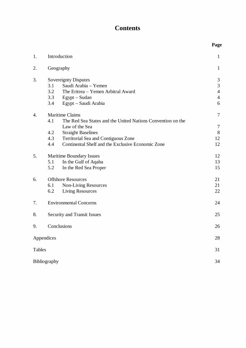
Contents
Page 1. Introduction 1 2. Geography 1 3. Sovereignty Disputes 3 3.1 Saudi Arabia – Yemen 3 3.2 The Eritrea – Yemen Arbitral Award 4 3.3 Egypt – Sudan 4 3.4 Egypt – Saudi Arabia 6 4. Maritime Claims 7
4.1 The Red Sea States and the United Nations Convention on the Law of the Sea 7
4.2 Straight Baselines 8 4.3 Territorial Sea and Contiguous Zone 12 4.4 Continental Shelf and the Exclusive Economic Zone 12 5. Maritime Boundary Issues 12 5.1 In the Gulf of Aqaba 13 5.2 In the Red Sea Proper 15 6. Offshore Resources 21 6.1 Non-Living Resources 21 6.2 Living Resources 22 7. Environmental Concerns 24 8. Security and Transit Issues 25 9. Conclusions 26 Appendices 28 Tables 31 Bibliography 34
List of Figures Page Figure 1 The Red Sea 2 Figure 2 Egypt’s Straight Baseline Claim, Points 41-56 5 Figure 3 Djibouti’s Straight Baselines 9 Figure 4 Egypt’s Straight Baselines 11 Figure 5 Proportionality in the Northern Gulf of Aqaba 13 Figure 6 Hypothetical Median Lines in the Northern Gulf of Aqaba 14 Figure 7 The Saudi Arabia – Sudan Common Zone 16 Figure 8 Saudi Arabia – Yemen 18 Figure 9 Eritrea – Yemen 19 Figure 10 Fish Catch in the Red Sea and Western Indian Ocean 23
IBRU Maritime Briefing 2001©
Parting the Red Sea: Boundaries, Offshore Resources and Transit
Daniel J. Dzurek
1. Introduction The Red Sea has been a pivot of international relations since the dawn of recorded history. The Egyptians navigated its length in the 15th century B.C. under Queen Hatshepsut. Since that time, the waterway has served for the transport of goods to distant lands. The first canal linking the Red Sea to the Mediterranean (via the Nile) was built by Pharaoh Sesostris in the second millennium B.C. The modern Suez Canal, though a remarkable accomplishment, is the fifth in a long line of such efforts (Lapidoth-Eschelbacher, 1983: 13-14; Fielden, 1978: 11 and 13). The Red Sea divides Africa from the Middle East and exhibits many of the salient issues of marine policy. There are only three settled maritime boundaries in the sea: between Israel and Jordan, between Eritrea and Yemen and, most recently, between Saudi Arabia and Yemen. Island disputes at both ends of the sea complicate efforts towards delimitation. Excessive or ambiguous straight baseline claims cloud boundary analysis. Saudi Arabia and Sudan have a preliminary agreement on exploiting metaliferous sediments in the central Red Sea, but practical development has not occurred. Tensions continue over other offshore resources, such as hydrocarbons and fisheries. Marine environmental degradation endangers fragile coral reefs and tourist attractions. Transit disputes dating to the Arab-Israeli conflict raise the questions of innocent and straits passage. Overarching all these issues are the larger regional tensions that inhibit cooperation in this crucial semi-enclosed sea. 2. Geography The Red Sea ranks eleventh among the world’s seas, having a surface area of some 438,000km2. For the purposes of this study, the Red Sea is taken to be bounded on the south by a line joining Ras si Ane [12°28.5’N, 43°19.6’E] on the African coast to Husn Murad [12°40.4’N, 43°30.2’E] on the Asian coast.1 It is bordered by eight countries: Djibouti, Egypt, Eritrea, Israel, Jordan, Saudi Arabia, Sudan, and Yemen. The Gulfs of Suez and Aqaba, and the Straits of Tiran, Jubal, and Bab al-Mandeb [Bab el-Mandeb] are included (see Figure 1). The Red Sea is long, narrow, and deep. It stretches 1,930 kilometres (km) from Suez to the Bab al-Mandeb, but it averages only 280km wide. Its maximum width is 360km. The sea’s average depth is 490 metres (m), but depths over 2,300m are found in the central area. Both the Gulf of Suez and the Gulf of Aqaba are narrow, finger-like projections, separated by the Sinai Peninsula. The Gulf of Suez, completely enclosed by Egypt, is 314km long and about 22km wide at its mouth. The Gulf of Aqaba, bordered by Egypt, Israel, Jordan, and Saudi Arabia, is 150km long and has a maximum width of 26km. The Gulf of Suez is
1 This usage follows the definition found in the International Convention for the Prevention of Pollution
from Ships (London, 1973) and that of Ruth Lapidoth-Eschelbacher, see below.
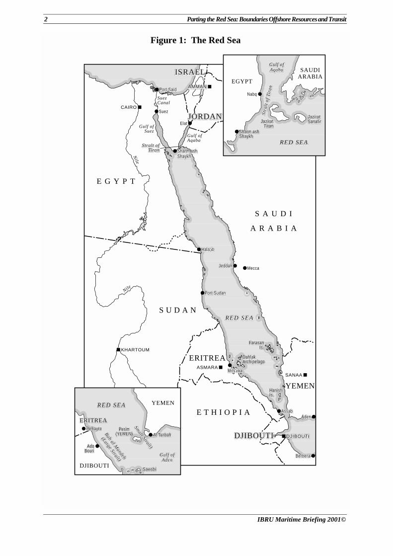
2 Parting the Red Sea: Boundaries Offshore Resources and Transit
IBRU Maritime Briefing 2001©
Figure 1: The Red Sea
■
■
■
■
CAIRO
AMMANAMMANAMMAN
KHARTOUM
SANAA
DJIBOUTIDJIBOUTIDJIBOUTI
S A U D I
A R A B I A
EGYPT
E G Y P T
S U D A N
E T H I O P I A
YEMEN
DJIBOUTIDJIBOUTIDJIBOUTI
ISRAELISRAELISRAEL
RED SEARED SEARED SEA
●
●
●
●
●
SAUDIARABIA
Nabq
Sharm ashSharm ashSharm ashShaykhShaykhShaykh
RED SEARED SEARED SEA
Gulf ofGulf ofGulf ofAqabaAqabaAqaba
JaziratJaziratJaziratSanafirSanafirSanafirJaziratJaziratJazirat
TiranTiranTiran
Stra
it o
f Ti
ran
Stra
it o
f Ti
ran
Stra
it o
f Ti
ran
DJIBOUTI
RED SEARED SEARED SEA
PerimPerimPerim(YEMEN)(YEMEN)(YEMEN) At TurbahAt TurbahAt Turbah
AdoAdoAdoBouriBouriBouri
RehaytoRehaytoRehayto
ERITREAERITREAERITREA
YEMEN
ERITREA
Bab al Mandeb
Bab al Mandeb
Bab al Mandeb
(Large Strait)
(Large Strait)
(Large Strait)
Small Strait)
Small Strait)
Small Strait)
Gulf ofGulf ofGulf ofAdenAdenAden
SawsbiSawsbiSawsbi
■ASMARA
●BerberaBerberaBerbera
●AdenAdenAden● AssabAssabAssab
●Mits’iwaMits’iwaMits’iwa
● Port SudanPort SudanPort Sudan
● Hala’ibHala’ibHala’ib
●JeddahJeddahJeddah● Mecca
● Sharm ashSharm ashSharm ashShaykhShaykhShaykh
● Suez
● Port SaidPort SaidPort Said
●ElatGulf of
Suez
Strait ofStrait ofStrait ofTiranTiranTiran
Gulf ofAqaba
SuezCanal
JORDANJORDANJORDAN
Nile
Nile
FarasanFarasanFarasanIs.Is.Is.
DahlakDahlakDahlakArchipelagoArchipelagoArchipelago
HanishHanishHanishIs.Is.Is.
■
Parting the Red Sea: Boundaries Offshore Resources and Transit 3
IBRU Maritime Briefing 2001©
shallow, but the Gulf of Aqaba has a maximum depth of 1,850m (Lapidoth-Eschelbacher, 1982: 2-4; Lindquist, 1998). The Red Sea is a geographically complex area that boasts numerous islands, coral formations and shoals. While the deep portions of the Red Sea and Gulf of Aqaba hold few offshore islands, numerous islets and reefs litter the Gulf of Suez and the southern Red Sea. The Red Sea is host to important marine resources including hydrocarbons, fisheries and a marine environment that lures tourists to the region. These offshore resources have proved to be the focus of many of the disputes among the littoral states (see Section 6). Additionally, the Red Sea is a strategic waterway between the ‘choke’ points of the Suez Canal and Bab al-Mandeb. The Red Sea owes its narrow, deep, linear structure to the great rift valley system, stretching from the Jordan valley (450km north) to the East African rift valley (extending 3,500km to the south), of which it forms a part. From the geophysical perspective the Red Sea represents one of the most active areas in the world as the Arabian and North African geological blocks move apart. This movement is still underway as indicated by extensive volcanic activity in the last 10,000 years, earthquake activity and the flow of hot brines in the central trough. In a sense, the geology of the Red Sea reflects its status as one of the political fault-lines of the world – a strategic link between the Mediterranean Sea and Indian Ocean, between Europe and East Asia. 3. Sovereignty Disputes Several sovereignty disputes may affect maritime boundary delimitation in the Red Sea. There is a latent island sovereignty dispute between Egypt and Saudi Arabia. The land boundary dispute over the Halaib Triangle between Egypt and Sudan spills into the adjacent maritime area and islands that front the coast of this disputed territory. However, two notable sovereignty disputes in the Red Sea have been resolved recently. An international tribunal has adjudicated the Eritrea-Yemen dispute over islands in the southern Red Sea and delimited the maritime boundary in that area and Saudi Arabia and Yemen have also resolved their long-standing boundary dispute, including its maritime sector. 3.1 Saudi Arabia – Yemen On 12 June 2000, Saudi Arabia and Yemen signed a land and maritime boundary treaty that apparently resolved a dispute over islands in the Red Sea. The treaty was ratified by the respective legislatures, and the instruments of ratification were to be exchanged in Sana’a on 3 July. The sovereignty of islands near the Saudi-Yemeni boundary, in particular the Farasan archipelago, was unclear, in part because the terminus on the 1939 Taif Line was uncertain. Saudi Arabia and Yemen began discussing their maritime boundary in 1996 and held the first substantive meeting during May 1997. However, in late May 1998, Saudi forces reportedly occupied Duwayyimah Island [Dhu Hirab, 16º23’33”N, 42º46’03”E] and Huraym [Harim] islands in the Red Sea. Yemen protested; Saudi Arabia refused to withdraw and demanded the Yemen leave Ashiq Island [16º26’N, 42º27’E]. Several Saudi and Yemeni soldiers were reported killed during July clashes on Duwayyimah Island. On 28 July 1998, following several high-level meetings, the Saudi and Yemeni Foreign Ministers signed minutes of an agreement
4 Parting the Red Sea: Boundaries Offshore Resources and Transit
IBRU Maritime Briefing 2001©
to separate their forces on Duwayyimah Island and renew boundary delimitation committee meetings. Ashiq Island clearly falls on the Saudi side of the first leg of the maritime boundary (see Figure 8) (Roberts, 2000; Schofield, 1996: 255-56).2
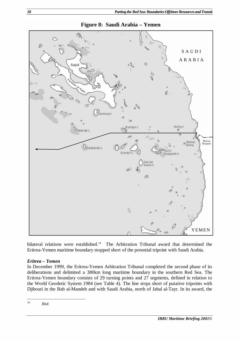
3.2 The Eritrea – Yemen Arbitral Award The Eritrea-Yemen dispute over several uninhabited island groups in the southern Red Sea dates to the dissolution of the Ottoman Empire and colonial actions by Italy and the United Kingdom. Eritrea and Yemen inherited the issue from the former Ethiopia and the Yemen Arab Republic (YAR). The YAR deployed troops to Jabal Zuqar and Hanish al Kabir in 1977, ostensibly to protect the Bab el-Mandeb Strait from Israel. Eritrean forces used the islands during Ethiopia’s civil war. Ethiopia and the YAR made declarations about their sovereignty over unnamed islands in the Red Sea when they signed the UN Conventions on the Law of the Sea (see Section 4.1). In 1995, Eritrea became alarmed when Yemen permitted an Italian firm to set up diving operations on Hanish al Kabir to promote it as a tourist attraction. The likelihood of offshore oil exploration in their overlapping concession blocks probably also raised interest in both countries. During November and December 1995, forces of Eritrea and Yemen clashed in the islands, with loss of life. The dispute threatened to become an Arab-African issue when the Arab League sided with Yemen and the Organization of African Unity objected to the League taking sides (Dzurek, 1996). On 3 October 1996, Eritrea and Yemen agreed to two-phase binding arbitration. The tribunal met in London and, on 9 October 1998, awarded Jabal al-Tayr, the Zuqar-Hanish and Zubayr groups to Yemen and South West Rocks, the Mohabbakah and Haycock groups to Eritrea (see Figure 9). The Arbitral Tribunal also directed that the traditional fishing regime continue for fishermen from both countries, including free access (Eritrea-Yemen Arbitration Tribunal, Phase I, Chapters I and XI; Kwiatkowska, 2000). In Phase II, the Tribunal delimited the Eritrea-Yemen maritime boundary (see Section 5.2). 3.3 Egypt – Sudan The sovereignty dispute over the Halaib [Hala’ib] Triangle and associated offshore areas relates to the interpretation of an 1899 agreement between Britain and the Khedive of Egypt for shared administration of the Sudan.3 That agreement defined the Sudan as “all the territories south of the 22nd parallel of latitude” (Brownlie, 1979: 111). An Arrêté and Decree of 1902 placed the lands of the Ababda tribe south of 22ºN under Egyptian administration, while grazing lands of the Beja tribe north of 22ºN (the Halaib Triangle) were put under Sudanese administration. Subsequent Egyptian administrative activities, maps, and other authorities confirmed the administrative nature of the line north of the 22nd parallel. The Sudanese administered territory comprises about 18,000km2 of desert. The area includes three small towns: Halaib, Shalataun, and Abu Ramad.
2 Yemen Times, issue 29 (2000) on http://www.yementimes.com/00/sii26/treaty.htm; Associated Press
(AP) 26 June 2000; Reuters [Sanaa] 15 January 1996; FBIS-NES-97-126, 127; FBIS-NES-98-146, 154, 159, 161; FBIS-NES-98-208, 209, 222, 334; FBIS-NES-2000-0211, 0627; Xinhua 5 August 1998.
3 Egypt and Sudan also disagree about the status of the Wadi Halfa Salient along the Nile. See Brownlie, 1979: 111-15.
Parting the Red Sea: Boundaries Offshore Resources and Transit 5
IBRU Maritime Briefing 2001©
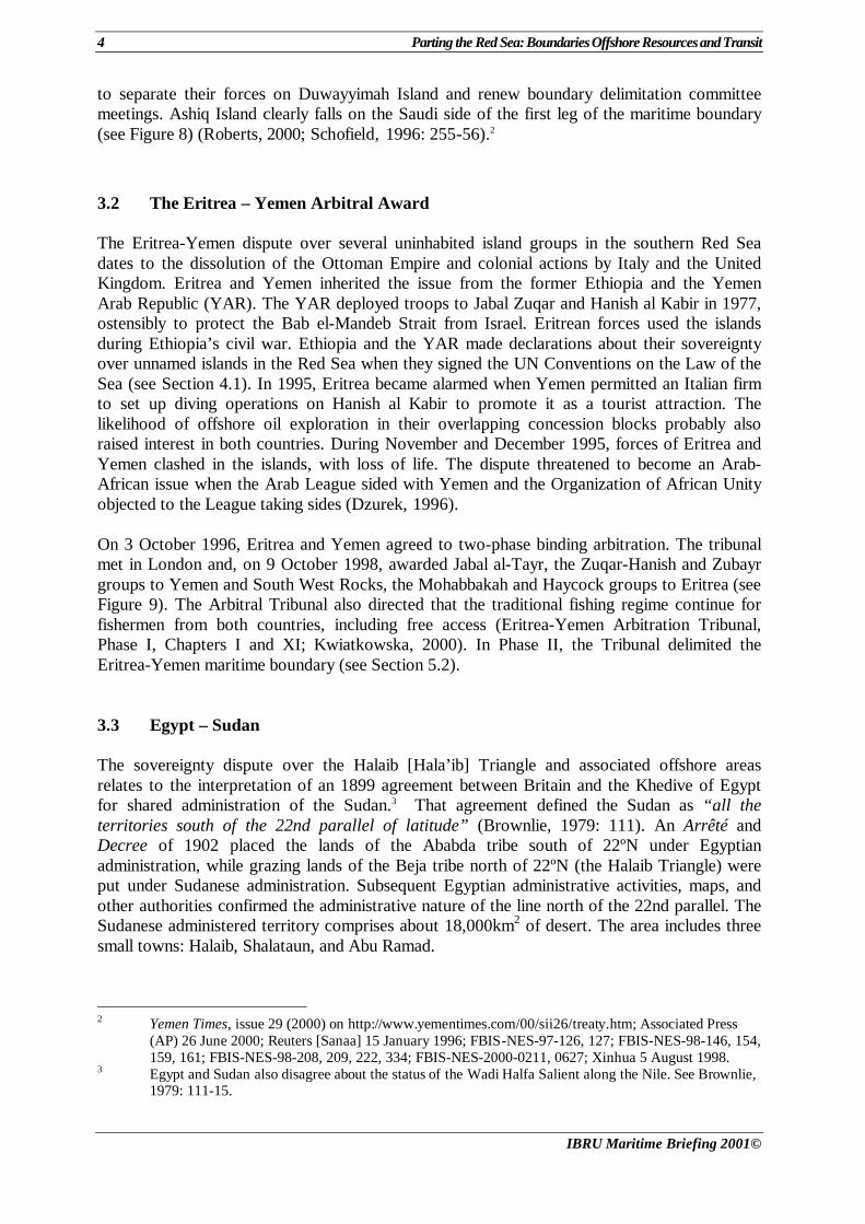
Figure 2: Egypt’s Straight Baseline Claim, Points 41-56
414141
424242
434343
444444
454545
464646474747
484848
494949
505050
515151
525252535353
545454
565656
E G Y P T
S U D A N
R e d S e aR e d S e aR e d S e a
EGYPT
SAUDIARABIA
SUDAN
St. JohnsSt. JohnsSt. JohnsIslandIslandIsland
Adm
inis
tratio
n Li
ne
555555
Halaib TriangeHalaib TriangeHalaib TriangeHalaibHalaibHalaib
Shi'b Abu FindirahShi'b Abu FindirahShi'b Abu Findirah
Ras BanasRas BanasRas Banas
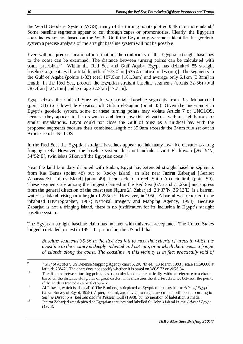
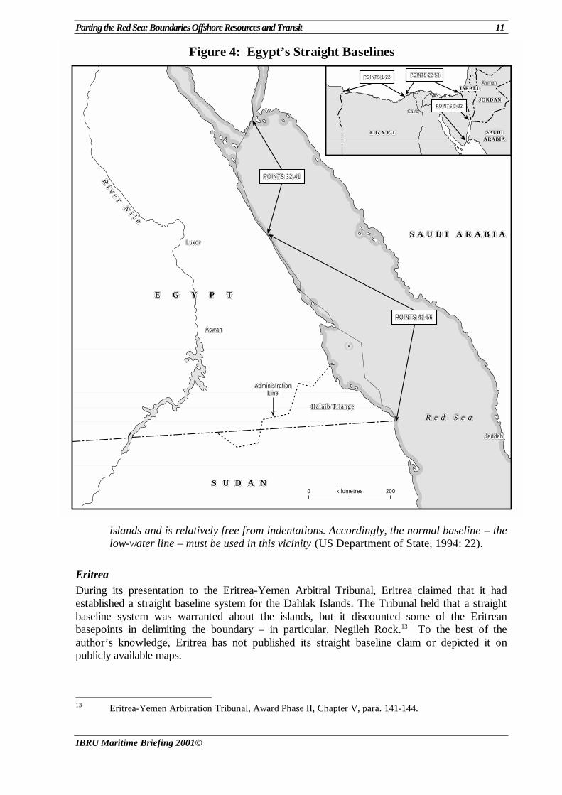
When Sudan became independent, in 1956, Egypt treated the 22nd parallel as the international boundary. In 1958 when Sudan prepared to hold elections in areas north of the parallel, the Egyptian government asserted sovereignty over all the territories north of 22ºN. Sudan replied in a 20 February 1958 letter to the UN Security Council that the territories claimed by Egypt were under the sovereignty of Sudan. The territorial dispute became more salient as other issues, such as water-sharing, aggravated bilateral relations (Brownlie, 1979: 112-13; UN Doc. S/3963, 1958). Tension over the disputed territory increased after General Al-Bashir came to power in Sudan following a coup in 1989. The straight baseline system that Egypt delimited in 1990 (see Section 4.1) enclosed the Halaib Triangle coastline, terminating with Point 56 at 22ºN latitude (see Figures 2 and 4). In 1991, Egypt objected when Sudan granted an oil exploration concession offshore of the Halaib Triangle. Sudan reiterated its sovereignty claim in 1992, but
6 Parting the Red Sea: Boundaries Offshore Resources and Transit
IBRU Maritime Briefing 2001©
offered to negotiate a solution. The countries formed a joint legal committee that was tasked with resolving the border dispute. However, Egypt made a distinction between administrative boundaries and oil and political borders. In 1994, Sudan suggested submitting the dispute to the International Court of Justice (ICJ). After the attempted assassination of Egyptian President Mubarak in Ethiopia on 26 June 1995 and allegations of Sudanese complicity, Egyptian forces expelled Sudanese police and officials from the Halaib area in July 1995. Two Sudanese policemen were killed. Sudan responded by asking the UN Security Council to intervene and force Egypt to accept international arbitration. It also seized Egyptian property, including the Khartoum branch of Cairo University. Sudan claimed that the Egyptian authorities in the Halaib Triangle were pressing Sudanese civilians to leave the area. On 31 January 1996, the Security Council passed a resolution calling on Sudan to extradite three suspects connected to the assassination attempt to Ethiopia.4 In 1998, Sudan restored Egyptian-owned properties that had been nationalised. Bilateral relations improved, and President Al-Bashir visited Egypt in December 1999. During the visit, the countries agreed to normalise relations and issued a joint communiqué pledging to resolve the Halaib issue “in an integrational brotherly context that would form a lead in the process of full integration between the two countries.” It remains to be seen if the promise leads to progress in resolving the territorial dispute.5 3.4 Egypt – Saudi Arabia The sovereignty of Tiran [27º57’N, 34º33’E] and Senafir islands at the entrance of the Gulf of Aqaba has been disputed between Egypt and Saudi Arabia (see Figure 1). Egypt occupied the two islands in 1949 with the concurrence of the Saudi government. Egypt proceeded to restrict passage through the Strait of Tiran. Israel occupied the islands in 1956, but withdrew in 1957 when the UN Emergency Force manned the Egyptian-Israeli armistice line. The UN forces withdrew from the islands in 1967, and Egypt reoccupied the islands. The Six Day War followed and Israel occupied the Sinai. Egypt and Saudi Arabia clarified their sovereignty claims to the islands in 1954, when Egypt informed the UN Security Council that the two islands had been Egyptian territory since the delimitation of the frontier between Egypt and the Ottoman Empire in 1906. In 1957, Saudi Arabia asserted its sovereignty in notes to diplomatic missions in Jiddah, and in a subsequent memorandum to the United Nations (El-Hakim, 1979: 137; Prescott, 1983: 174). The sovereignty dispute appears to be quiescent. Egyptian forces continue to occupy outposts on the islands, but Senafir (Sanafir) and Tiran islands are depicted as Saudi territory in the 1989 National Guide and Atlas of the Kingdom of Saudi Arabia.6 The islands seem to be off-limits to civilians. Diving tours of the Strait of Tiran conduct excursions to the waters around
4 BBC SWB ME/1299 A/6, ME/1307 A/11, and ME/1310 A/3; Le Monde 30 June 1995; The Times 7 July
1995; Reuters 27 July 1995, 7 August 1995 and 4 March 1996; UN Doc. S/1044, 1996. 5 PANA 15 March 1998; Egypt-Sudan Communiqué, 2 December 1999. 6 National Guide and Atlas of the Kingdom of Saudi Arabia (Jeddah, 1989), plate A7, distributed by the
Royal Embassy of Saudi Arabia, Washington, DC.
Parting the Red Sea: Boundaries Offshore Resources and Transit 7
IBRU Maritime Briefing 2001©
the islands, but do not land people there.7 Egypt’s 1990 straight baseline claim includes virtually its entire coastline and nearshore islands in the Mediterranean and Red seas, but excludes these islands (see Figure 4). Egypt may no longer claim the islands. Alternatively, Egypt may not have enclosed the islands to forego closing the Strait of Tiran within straight baselines and possibly triggering a strong response from the maritime powers and Israel. Regardless of the legal status of the islands, there have been no incidents on or near the islands between Egypt and Saudi Arabia in the last several years. Perhaps, Egypt and Saudi Arabia may have some bilateral agreement permitting Egyptian forces on the islands, but no such accord has been publicised.8 4. Maritime Claims Most of the Red Sea countries claim the full suite of maritime rights and jurisdictional zones. The maritime claims of the Red Sea states are outlined below and summarised in Table 1. Indeed, even countries that have not formally promulgated such zones appear to exercise these rights. For example, even though Eritrea has not formally claimed EEZ jurisdiction, the Eritrea-Yemen Arbitration Tribunal delimited a maritime boundary between those states with reference to their territorial seas, continental shelves and EEZs. Although Eritrea only gained independence from Ethiopia on 27 April 1993, as a successor state to Ethiopia and having inherited the entirety of Ethiopia’s coastline on the Red Sea, it can be assumed that Eritrea has also inherited Ethiopia’s maritime claims. In Yemen’s case, on 22 May 1990 the Republic of Yemen was established with the merger of the Yemen Arab Republic (YAR, North Yemen) and the People’s Democratic Republic of Yemen (PDRY, South Yemen). All treaties and agreements concluded between either the YAR or PDRY and other states and international organisations in accordance with international law which were in force on 22 May 1990 remained in effect. 4.1 The Red Sea States and the United Nations Convention on the Law of the Sea All the Red Sea littoral states except Eritrea and Israel are parties to the 1982 UN Convention on the Law of the Sea (UNCLOS) (see Table 2). Egypt, Saudi Arabia, Sudan, the YAR and PDRY did, however, all make statements on signature or ratification of UNCLOS. On signing the UNCLOS the YAR made a declaration, paragraph three of which stated that:
The Yemen Arab Republic confirms its national sovereignty over all the islands in the Red Sea and the Indian Ocean which have been its dependencies since the period when the Yemen and the Arab countries were under Turkish administration.
7 See Sun Tours website (www.suntours.com.jo). On the “Strait of Tiran” page at the website, Sun Tours
states that “Both islands officially belong to Saudi Arabia but are being used by Egypt. Because of strict military regulations, it's not possible to enter the islands.”
8 The author’s inquiries to the embassies of Egypt and Saudi Arabia in Washington regarding the status of the islands received no replies.
8 Parting the Red Sea: Boundaries Offshore Resources and Transit
IBRU Maritime Briefing 2001©
This led the Ethiopian ministry of foreign affairs to send a protest note to the Secretary General of the United Nations on 7 November 1984 referring to the YAR declaration and concluding that:
…the Provisional Military Government of Socialist Ethiopia, wishes to place on record that paragraph 3 of the declaration by the Yemen Arab Republic cannot in any way affect Ethiopia’s sovereignty over all the islands in the Red Sea forming part of its national territory.
The Eritrea (Ethiopia)-Yemen dispute concerning sovereignty over islands in the southern Red Sea and the maritime boundary between them was finally resolved through decisions made by an international tribunal (see Section 3.2). The declarations made on signature and ratification or accession to UNCLOS are also of interest because of their implications for innocent passage through the territorial seas of the littoral states, transit passage through international straits and the movement of nuclear powered or armed vessels. The implications of these declarations are dealt with in Section 8. 4.2 Straight Baselines Of the various jurisdictional zones in the Red Sea, claims to straight baseline systems by several of the coastal countries present the most significant difficulties in interpretation. Straight baselines, if used in the construction of median-line boundaries, have the potential to markedly influence boundaries and disputes. A review of baseline claims is necessary before examining the Red Sea boundaries and maritime disputes.
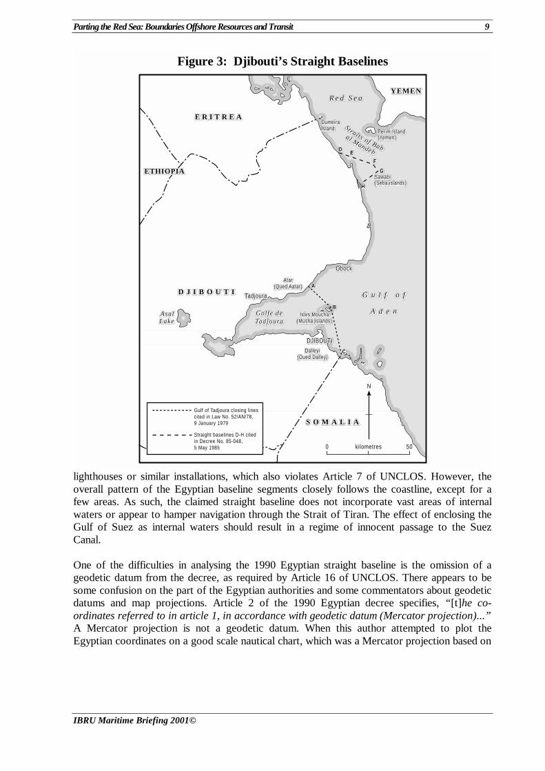
Djibouti Djibouti defined straight baselines out to the Seba Islands [Sawabi Islands], at the southern entrance to the Bab al-Mandeb, in 1961 (see Figure 3). The system links the mainland point D [12º 32.10’N, 43º 15.22’E] to the tiny islets extending about 13km from the mainland. The six small islets lie in a line roughly perpendicular to the coast; they are not fringing islands, as required in Article 7 of UNCLOS. The seaward-most point [F, 12º31.20’N, 43º25.80’E] is on Kadd Dabali islet, some 18km from Yemen’s Perim [Barim] Island. Djibouti’s straight baseline system could have a significant influence on its boundary with Yemen, if given full effect. In 1989, the United States protested Djibouti’s straight baseline claim (US Department of State, 1992).
Egypt In 1951, Egypt decreed straight baselines along its coasts, but did not delimit the baseline segments. In 1990, Egypt defined this straight baseline claim and provided the coordinates of the turning points to the United Nations (see Figures 2 and 4). One analysis has characterised Egypt’s straight baselines, in the Mediterranean, as “illegitimate though moderate” (Francalanci and Scovazzi, 1994: 132). The same could be said of its baseline claims in the Red Sea, where Egypt claims a continuous baseline system extending from near its boundary with Israel across the Gulf of Suez to its claimed boundary with Sudan. Long stretches of Egyptian coastline in the Gulf of Aqaba are not deeply indented or fringed with islands, which are the principal requirements before a country may claim straight baselines. Many of the turning points specified in the Red Sea proper, appear to be low-tide elevations without
Parting the Red Sea: Boundaries Offshore Resources and Transit 9
IBRU Maritime Briefing 2001©
Figure 3: Djibouti’s Straight Baselines
D J I B O U T ID J I B O U T ID J I B O U T I
N
ObockObockObock
ETHIOPIAETHIOPIAETHIOPIA
S O M A L I AS O M A L I AS O M A L I A
YEMENYEMENYEMEN
E R I T R E AE R I T R E AE R I T R E A
G u l f o fG u l f o fG u l f o f
A d e nA d e nA d e n
R e d S e aR e d S e aR e d S e a
kilometres0 50
Golfe deGolfe deGolfe deTadjouraTadjouraTadjoura
AsalAsalAsalLakeLakeLake
TadjouraTadjouraTadjoura
DJIBOUTIDJIBOUTIDJIBOUTI
Isles MouchaIsles MouchaIsles Moucha(Musha Islands)(Musha Islands)(Musha Islands)
AtarAtarAtar(Qued Aatar)(Qued Aatar)(Qued Aatar)
DalleyiDalleyiDalleyi(Oued Dalley)(Oued Dalley)(Oued Dalley)
SawabiSawabiSawabi(Seba islands)(Seba islands)(Seba islands)
DDDEEE
FFF
GGG
HHH
Perim IslandPerim IslandPerim Island(Yemen)(Yemen)(Yemen)
SSS ttt rrr aaa iii ttt sss ooo fff BBBaaabbb
aaa lll MMMaaannndddeeebbb
CCC
BBB
AAA
DumeiraDumeiraDumeiraIslandIslandIsland
Gulf of Tadjoura closing linescited in Law No. 52/AN/78,9 January 1979
Straight baselines D-H citedin Decree No. 85-048,5 May 1985
lighthouses or similar installations, which also violates Article 7 of UNCLOS. However, the overall pattern of the Egyptian baseline segments closely follows the coastline, except for a few areas. As such, the claimed straight baseline does not incorporate vast areas of internal waters or appear to hamper navigation through the Strait of Tiran. The effect of enclosing the Gulf of Suez as internal waters should result in a regime of innocent passage to the Suez Canal. One of the difficulties in analysing the 1990 Egyptian straight baseline is the omission of a geodetic datum from the decree, as required by Article 16 of UNCLOS. There appears to be some confusion on the part of the Egyptian authorities and some commentators about geodetic datums and map projections. Article 2 of the 1990 Egyptian decree specifies, “[t]he co-ordinates referred to in article 1, in accordance with geodetic datum (Mercator projection)...” A Mercator projection is not a geodetic datum. When this author attempted to plot the Egyptian coordinates on a good scale nautical chart, which was a Mercator projection based on
10 Parting the Red Sea: Boundaries Offshore Resources and Transit
IBRU Maritime Briefing 2001©
the World Geodetic System (WGS), many of the turning points plotted 0.4km or more inland.9 Some baseline segments appear to cut through capes or promontories. Clearly, the Egyptian coordinates are not based on the WGS. Until the Egyptian government identifies its geodetic system a precise analysis of the straight baseline system will not be possible. Even without precise locational information, the conformity of the Egyptian straight baselines to the coast can be examined. The distance between turning points can be calculated with some precision.10 Within the Red Sea and Gulf Aqaba, Egypt has delimited 55 straight baseline segments with a total length of 973.0km [525.4 nautical miles (nm)]. The segments in the Gulf of Aqaba (points 1-32) total 187.6km [101.3nm] and average only 6.1km [3.3nm] in length. In the Red Sea, proper, the Egyptian straight baseline segments (points 32-56) total 785.4km [424.1nm] and average 32.8km [17.7nm]. Egypt closes the Gulf of Suez with two straight baseline segments from Ras Muhammad (point 33) to a low-tide elevation off Giftun el-Saghir (point 35). Given the uncertainty in Egypt’s geodetic system, some of these turning points may violate Article 7 of UNCLOS, because they appear to be drawn to and from low-tide elevations without lighthouses or similar installations. Egypt could not close the Gulf of Suez as a juridical bay with the proposed segments because their combined length of 35.9nm exceeds the 24nm rule set out in Article 10 of UNCLOS. In the Red Sea, the Egyptian straight baselines appear to link many low-tide elevations along fringing reefs. However, the baseline system does not include Jazirat El-Ikhwan [26°19’N, 34°52’E], twin islets 61km off the Egyptian coast.11 Near the land boundary disputed with Sudan, Egypt has extended straight baseline segments from Ras Banas (point 48) out to Rocky Island, an islet near Jazirat Zabarjad [Geziret Zabargad/St. John’s Island] (point 49), then back to a reef, Shi’b Abu Findirah (point 50). These segments are among the longest claimed in the Red Sea [67.6 and 75.2km] and digress from the general direction of the coast (see Figure 2). Zabarjad [23º37’N, 36º12’E] is a barren, waterless island, rising to a height of 235m.12 However, in 1950, Zabarjad was reported to be inhabited (Hydrographer, 1987; National Imagery and Mapping Agency, 1998). Because Zabarjad is not a fringing island, there is no justification for its inclusion in Egypt’s straight baseline system. The Egyptian straight baseline claim has not met with universal acceptance. The United States lodged a detailed protest in 1991. In particular, the US held that:
Baseline segments 36-56 in the Red Sea fail to meet the criteria of areas in which the coastline in the vicinity is deeply indented and cut into, or in which there exists a fringe of islands along the coast. The coastline in this vicinity is in fact practically void of
9 “Gulf of Aqaba”, US Defense Mapping Agency chart 6220, 7th ed. (13 March 1993), scale 1:150,000 at
latitude 28°47’. The chart does not specify whether it is based on WGS 72 or WGS 84. 10 The distance between turning points has been calculated mathematically, without reference to a chart,
based on the distance along arcs of great circles. This measures the shortest distance between the points if the earth is treated as a perfect sphere.
11 Al Ikhwan, which is also called The Brothers, is depicted as Egyptian territory in the Atlas of Egypt (Giza: Survey of Egypt, 1928). A pier, bollard, and navigation light are on the north islet, according to Sailing Directions: Red Sea and the Persian Gulf (1998), but no mention of habitation is made.
12 Jazirat Zabarjad was depicted as Egyptian territory and labelled St. John's Island in the Atlas of Egypt (1928).
Parting the Red Sea: Boundaries Offshore Resources and Transit 11
IBRU Maritime Briefing 2001©
Figure 4: Egypt’s Straight Baselines
S A U D I A R A B I AS A U D I A R A B I AS A U D I A R A B I A
E G Y P TE G Y P TE G Y P T
S U D A NS U D A NS U D A N
R e d S e aR e d S e aR e d S e a
RRRiii
vvveee
rrrNNN
iii lll eee
Halaib TriangeHalaib TriangeHalaib Triange
POINTS 32-41POINTS 32-41POINTS 32-41
POINTS 41-56POINTS 41-56POINTS 41-56
N
kilometres 2000
LuxorLuxorLuxor
AswanAswanAswan
JeddahJeddahJeddah
AdministrationAdministrationAdministrationLineLineLine
E G Y P TE G Y P TE G Y P T SAUDISAUDISAUDIARABIAARABIAARABIA
JORDANJORDANJORDAN
ISRAELISRAELISRAEL
POINTS 1-22POINTS 1-22POINTS 1-22 POINTS 22-53POINTS 22-53POINTS 22-53
POINTS 1-32POINTS 1-32POINTS 1-32CairoCairoCairo
AmmanAmmanAmman
islands and is relatively free from indentations. Accordingly, the normal baseline – the low-water line – must be used in this vicinity (US Department of State, 1994: 22).
Eritrea During its presentation to the Eritrea-Yemen Arbitral Tribunal, Eritrea claimed that it had established a straight baseline system for the Dahlak Islands. The Tribunal held that a straight baseline system was warranted about the islands, but it discounted some of the Eritrean basepoints in delimiting the boundary – in particular, Negileh Rock.13 To the best of the author’s knowledge, Eritrea has not published its straight baseline claim or depicted it on publicly available maps.
13 Eritrea-Yemen Arbitration Tribunal, Award Phase II, Chapter V, para. 141-144.
12 Parting the Red Sea: Boundaries Offshore Resources and Transit
IBRU Maritime Briefing 2001©
Saudi Arabia On 21 February 1958, Saudi Arabia decreed straight baselines in terms similar to the 1951 Egyptian decree (US Department of State, 1970). The language of the decree appears to treat any feature not below lowest low-water as an island. Such a definition is at variance with UNCLOS language. No charts or coordinates of the Saudi baselines have been published to date. Without further data, it is not possible to determine where these baseline segments are located.
Sudan Sudan’s 1970 Territorial Waters and Continental Shelf Act claimed straight baselines across bays, from the mainland to the outer shores of islands within 12nm from the mainland, and linking islands that are not more than 12nm apart (Roach and Smith, 1994: 65; Lapidoth-Eschelbacher, 1982). To date, Sudan has not delimited these baseline segments. 4.3 Territorial Sea and Contiguous Zone All the Red Sea littoral states claim a 12nm breadth territorial sea, except for Jordan which maintains a 3nm claim. As previously noted, although Eritrea has not made an explicit claim to territorial sea, it can be assumed to have inherited Ethiopia’s 12nm claim. Additionally, Djibouti, Egypt and Yemen all claim contiguous zones out to 24nm while Saudi Arabia and Sudan claim contiguous zone jurisdiction to only 18nm from their baselines. 4.4 Continental Shelf and the Exclusive Economic Zone According to Article 77(3) of UNCLOS: “The rights of the coastal State over the continental shelf do not depend on occupation, effective or notional, or on any express proclamation.” Nevertheless, Djibouti, Egypt and Yemen (PDRY) have made explicit claims to continental shelf jurisdiction. The same three states have also claimed exclusive economic zone (EEZ) rights (see Table 1). 5. Maritime Boundary Issues Only three of thirteen potential boundaries in the Red Sea and Gulf of Aqaba have been delimited. In addition, Saudi Arabia and Sudan have a joint development agreement relating to the Red Sea brines that straddle their prospective boundary. Seven boundaries are principally of the adjacent type; six will be between opposite states. Because the Gulf of Aqaba is less than 26nm wide, most boundaries within it will separate the territorial seas of the littoral states. In the Red Sea proper, potential maritime boundaries will apply to all types of offshore jurisdictional zones. The status of boundaries in the Red Sea and estimates for the lengths of the shorter boundaries, assuming a median line delimitation, are provided in Table 3. The salient aspects of each potential or actual boundary are treated below.
Parting the Red Sea: Boundaries Offshore Resources and Transit 13
IBRU Maritime Briefing 2001©
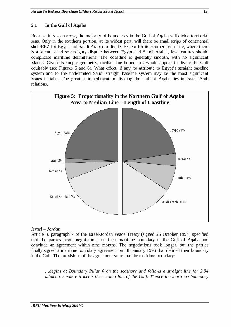
Figure 5: Proportionality in the Northern Gulf of Aqaba Area to Median Line – Length of Coastline
Saudi Arabia 16%
Jordan 8%
Israel 4%
Egypt 23%
Saudi Arabia 19%
Jordan 5%
Israel 2%
Egypt 23%
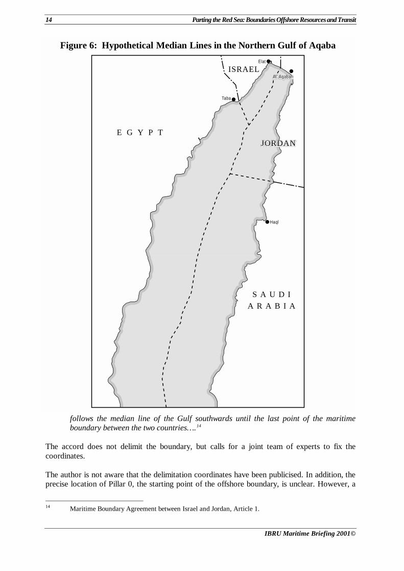
5.1 In the Gulf of Aqaba Because it is so narrow, the majority of boundaries in the Gulf of Aqaba will divide territorial seas. Only in the southern portion, at its widest part, will there be small strips of continental shelf/EEZ for Egypt and Saudi Arabia to divide. Except for its southern entrance, where there is a latent island sovereignty dispute between Egypt and Saudi Arabia, few features should complicate maritime delimitations. The coastline is generally smooth, with no significant islands. Given its simple geometry, median line boundaries would appear to divide the Gulf equitably (see Figures 5 and 6). What effect, if any, to attribute to Egypt’s straight baseline system and to the undelimited Saudi straight baseline system may be the most significant issues in talks. The greatest impediment to dividing the Gulf of Aqaba lies in Israeli-Arab relations.
Israel – Jordan Article 3, paragraph 7 of the Israel-Jordan Peace Treaty (signed 26 October 1994) specified that the parties begin negotiations on their maritime boundary in the Gulf of Aqaba and conclude an agreement within nine months. The negotiations took longer, but the parties finally signed a maritime boundary agreement on 18 January 1996 that defined their boundary in the Gulf. The provisions of the agreement state that the maritime boundary:
…begins at Boundary Pillar 0 on the seashore and follows a straight line for 2.84 kilometres where it meets the median line of the Gulf. Thence the maritime boundary
14 Parting the Red Sea: Boundaries Offshore Resources and Transit
IBRU Maritime Briefing 2001©
Figure 6: Hypothetical Median Lines in the Northern Gulf of Aqaba
E G Y P T
S A U D I
A R A B I A
JORDANJORDANJORDAN
ISRAEL●Elat
●
Al’ AqabahAl’ AqabahAl’ Aqabah
● Haql
●Taba
follows the median line of the Gulf southwards until the last point of the maritime boundary between the two countries….14
The accord does not delimit the boundary, but calls for a joint team of experts to fix the coordinates. The author is not aware that the delimitation coordinates have been publicised. In addition, the precise location of Pillar 0, the starting point of the offshore boundary, is unclear. However, a
14 Maritime Boundary Agreement between Israel and Jordan, Article 1.
Parting the Red Sea: Boundaries Offshore Resources and Transit 15
IBRU Maritime Briefing 2001©
median line estimate suggests that the final boundary will be about 12km in length and divide territorial seas of the two countries. It is unclear how the subsequent delimitation will treat the Egypt-Israel-Jordan tripoint (see Figure 6) (Charney, 1996). Egypt – Israel There is a very short (approximately 5km) potential territorial sea boundary between Egypt and Israel in the northern Gulf. There should be no intrinsic difficulty in delimiting it, but the negotiation of this boundary may well be linked to settling the Egypt-Israel-Palestinian Authority boundaries in the Mediterranean – a much more daunting prospect. Egypt – Jordan Egypt and Jordan will have a short territorial sea boundary in the northern Gulf of some 10km [5.4nm]. Because they hold opposite coasts and the distance between them is less than 24nm, a strict median line would seem both appropriate and equitable. The only likely complication would appear to be determining their tripoints with Israel and Saudi Arabia. Egypt – Saudi Arabia In the Gulf of Aqaba, Egypt and Saudi Arabia will need to delimit the longest of the boundaries among the Gulf’s coastal states. Where the Gulf is widest, in the south, there will be small strips of continental shelf/EEZ jurisdiction to delimit. Elsewhere, the Egypt-Saudi boundary will divide territorial seas. Any delimitation would confirm the status of Tiran and Senafir islands at the entrance of the Gulf (see Section 3.4). Presumably, Egypt and Saudi Arabia will delimit the Gulf in the same process as settling their longer boundary in the northern Red Sea, which is likely to represent a more complex negotiation. 5.2 In the Red Sea Proper Unlike the Gulf of Aqaba, the Red Sea is studded with mid-sea and coastal islands and rocks, which have the potential significantly to complicate boundary delimitation negotiations. Sovereignty disputes and ambiguous straight baseline claims further cloud the process. Egypt – Saudi Arabia Even if Egypt and Saudi Arabia have laid the Tiran and Senafir Islands dispute to rest, dividing the waters of the northern Red Sea will be complicated. The effect of several mid-sea Egyptian islets may be at issue. Al-Ikhwan, Daedalus Reef [Abu el Kizan, 24º56’N, 35º52’E], and Jazirat Zabarjad could significantly deflect a median line to Saudi Arabia’s disadvantage. The first two features were not enclosed in Egypt’s 1990 straight baseline system, but Jazirat Zabarjad is enclosed. Any Egyptian-Saudi negotiation would also need to address the location of their tripoint with Sudan, which is influenced by the Halaib Triangle Dispute. The author is not aware of any boundary negotiations between Egypt and Saudi Arabia underway at the time of writing. Egypt – Sudan The Egyptian-Sudanese claims relating to the Halaib Triangle have been discussed above. Barring some joint development agreement, settlement of an offshore boundary is unlikely as long as the two governments contest the large coastal area and its nearshore islands.
16 Parting the Red Sea: Boundaries Offshore Resources and Transit
IBRU Maritime Briefing 2001©
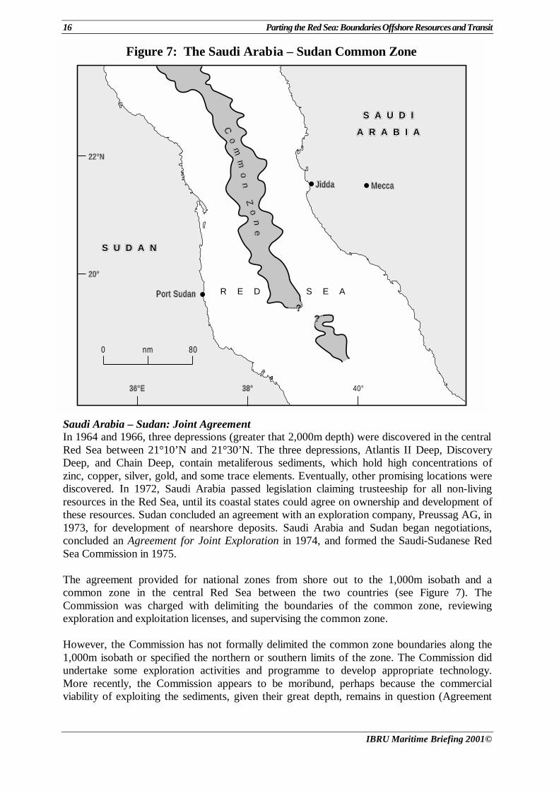
Figure 7: The Saudi Arabia – Sudan Common Zone
nm 800
R E D S E A
● ●
●
CCCooo
mmmmmm
ooonnn
ZZZooo
nnneee
??????
S A U D IS A U D IS A U D I
A R A B I AA R A B I AA R A B I A
S U D A NS U D A NS U D A N
JiddaJiddaJidda MeccaMeccaMecca
Port SudanPort SudanPort Sudan
36°E36°E36°E 38°38°38° 40°
22°N22°N22°N
20°20°20°
Saudi Arabia – Sudan: Joint Agreement In 1964 and 1966, three depressions (greater that 2,000m depth) were discovered in the central Red Sea between 21°10’N and 21°30’N. The three depressions, Atlantis II Deep, Discovery Deep, and Chain Deep, contain metaliferous sediments, which hold high concentrations of zinc, copper, silver, gold, and some trace elements. Eventually, other promising locations were discovered. In 1972, Saudi Arabia passed legislation claiming trusteeship for all non-living resources in the Red Sea, until its coastal states could agree on ownership and development of these resources. Sudan concluded an agreement with an exploration company, Preussag AG, in 1973, for development of nearshore deposits. Saudi Arabia and Sudan began negotiations, concluded an Agreement for Joint Exploration in 1974, and formed the Saudi-Sudanese Red Sea Commission in 1975. The agreement provided for national zones from shore out to the 1,000m isobath and a common zone in the central Red Sea between the two countries (see Figure 7). The Commission was charged with delimiting the boundaries of the common zone, reviewing exploration and exploitation licenses, and supervising the common zone. However, the Commission has not formally delimited the common zone boundaries along the 1,000m isobath or specified the northern or southern limits of the zone. The Commission did undertake some exploration activities and programme to develop appropriate technology. More recently, the Commission appears to be moribund, perhaps because the commercial viability of exploiting the sediments, given their great depth, remains in question (Agreement
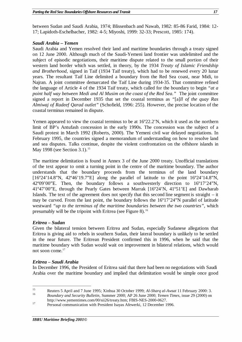
Parting the Red Sea: Boundaries Offshore Resources and Transit 17
IBRU Maritime Briefing 2001©
between Sudan and Saudi Arabia, 1974; Blissenbach and Nawab, 1982: 85-86 Farid, 1984: 12-17; Lapidoth-Eschelbacher, 1982: 4-5; Miyoshi, 1999: 32-33; Prescott, 1985: 174). Saudi Arabia – Yemen Saudi Arabia and Yemen resolved their land and maritime boundaries through a treaty signed on 12 June 2000. Although much of the Saudi-Yemeni land frontier was undelimited and the subject of episodic negotiations, their maritime dispute related to the small portion of their western land border which was settled, in theory, by the 1934 Treaty of Islamic Friendship and Brotherhood, signed in Taif (1934 Taif treaty), which had to be renewed every 20 lunar years. The resultant Taif Line delimited a boundary from the Red Sea coast, near Midi, to Najran. A joint committee demarcated the Taif Line during 1934-35. That committee refined the language of Article 4 of the 1934 Taif treaty, which called for the boundary to begin “at a point half way between Medi and Al Musim on the coast of the Red Sea.” The joint committee signed a report in December 1935 that set the coastal terminus as “[a]ll of the quay Ras Almiwaj of Radeef Qarad outlet” (Schofield, 1996: 255). However, the precise location of the coastal terminus remained in dispute. Yemen appeared to view the coastal terminus to be at 16º22.2’N, which it used as the northern limit of BP’s Antufash concession in the early 1990s. The concession was the subject of a Saudi protest in March 1992 (Roberts, 2000). The Yemeni civil war delayed negotiations. In February 1995, the countries signed a memorandum of understanding on how to resolve land and sea disputes. Talks continue, despite the violent confrontation on the offshore islands in May 1998 (see Section 3.1).15 The maritime delimitation is found in Annex 3 of the June 2000 treaty. Unofficial translations of the text appear to omit a turning point in the centre of the maritime boundary. The author understands that the boundary proceeds from the terminus of the land boundary [16º24’14.8”N, 42º46’19.7”E] along the parallel of latitude to the point 16º24’14.8”N, 42º09’00”E. Then, the boundary follows a southwesterly direction to 16º17’24”N, 41º47’00”E, through the Pearly Gates between Marrak [16º24’N, 41º51’E] and Dawharab Islands. The text of the agreement does not specify that this second line segment is straight – it may be curved. From the last point, the boundary follows the 16º17’24”N parallel of latitude westward “up to the terminus of the maritime boundaries between the two countries”, which presumably will be the tripoint with Eritrea (see Figure 8).16 Eritrea – Sudan Given the bilateral tension between Eritrea and Sudan, especially Sudanese allegations that Eritrea is giving aid to rebels in southern Sudan, their lateral boundary is unlikely to be settled in the near future. The Eritrean President confirmed this in 1996, when he said that the maritime boundary with Sudan would wait on improvement in bilateral relations, which would not soon come.17 Eritrea – Saudi Arabia In December 1996, the President of Eritrea said that there had been no negotiations with Saudi Arabia over the maritime boundary and implied that delimitation would be simple once good
15 Reuters 5 April and 7 June 1995; Xinhua 30 October 1999; Al-Sharq al-Awsat 11 February 2000: 3. 16 Boundary and Security Bulletin, Summer 2000; AP 26 June 2000; Yemen Times, issue 29 (2000) on
http://www.yementimes.com/00/sii26/treaty.htm; FBIS-NES-2000-0627. 17 Personal communication with President Isayas Afewerki, 12 December 1996.
18 Parting the Red Sea: Boundaries Offshore Resources and Transit
IBRU Maritime Briefing 2001©
Figure 8: Saudi Arabia – Yemen
S A U D I
A R A B I A
YEMEN
Sajid
Farasan al Kabir
Dumsuq I.Dumsuq I.Dumsuq I.
Rumayn I.Rumayn I.Rumayn I.Marrak I.Marrak I.Marrak I.
Dwaharab I.Dwaharab I.Dwaharab I.
Sumayr I.Sumayr I.Sumayr I.
JaziratJaziratJaziratFasht I.Fasht I.Fasht I.
JuzurJuzurJuzurDuqaylah I.Duqaylah I.Duqaylah I.
MarsaBaqlah
Ashiq I.Ashiq I.Ashiq I.
ZahratZahratZahratAshiqAshiqAshiq
bilateral relations were established.18 The Arbitration Tribunal award that determined the Eritrea-Yemen maritime boundary stopped short of the potential tripoint with Saudi Arabia. Eritrea – Yemen In December 1999, the Eritrea-Yemen Arbitration Tribunal completed the second phase of its deliberations and delimited a 380km long maritime boundary in the southern Red Sea. The Eritrea-Yemen boundary consists of 29 turning points and 27 segments, defined in relation to the World Geodetic System 1984 (see Table 4). The line stops short of putative tripoints with Djibouti in the Bab al-Mandeb and with Saudi Arabia, north of Jabal al-Tayr. In its award, the
18 Ibid.
Parting the Red Sea: Boundaries Offshore Resources and Transit 19
IBRU Maritime Briefing 2001©
Figure 9: Eritrea – Yemen
E R I T R E A
R E P U B L I C
O F
Y E M E N
12
3
45
67
89
10
11
12
13
14
1516
1718
1920
21
22
23 2425 26
27 2829
RRReee
ddd
SSSeee
aaa
16°
15°
14°
13°N
39°E 40° 42° 43°43°43°41°
E T H I O P I A
1000 kilometres
DDDaaa hhh lll aaa
kkkAAA
rrr ccchhh
iii pppeee
lll aaaggg
ooo
Massawa
Assab
Al Hudayda
Jabal al-TayrJabal al-TayrJabal al-Tayr
ZubayrZubayrZubayrGroupGroupGroup
Bab alBab alBab alMandabMandabMandab
nautical miles0 50
17
2120
19
18
15
14
13
16
E R I T R E A
R E P U B L I CR E P U B L I CR E P U B L I CO FO FO F
Y E M E NY E M E NY E M E N
Jabal ZuqarJabal ZuqarJabal Zuqar
Lesser HanishLesser HanishLesser Hanish
HaycocksHaycocksHaycocks
South WestSouth WestSouth WestRocksRocksRocks
MohabbakahMohabbakahMohabbakahIslandsIslandsIslands
Greater HanishGreater HanishGreater Hanish
Zuqar - HanishZuqar - HanishZuqar - HanishGroupGroupGroup
Tribunal gave a relatively detailed review of the resulting boundary and how it arrived at that delimitation (Kwiatkowska, 2000).19 Both countries had proposed versions of a median line, though discounting various features. The Tribunal settled on a boundary that was generally equidistant from the respective mainlands, including fringing islands such as Eritrea’s Dahlak Archipelago (see Figure 9). As might be expected, the Tribunal set a boundary between those advocated by each side. The Tribunal distinguished three sections of the boundary. In the northern portion of the boundary, the Tribunal delimited a “mainland-coastal median” line for points 1 through 13.20 It ignored mid-sea islands (Jabal al-Tayr and the Zubayr group) and based the delimitation on the fact that this portion of the boundary was a continental shelf/EEZ boundary that did not divide territorial seas. In applying Articles 74 and 83 of UNCLOS, the Tribunal arrived at a modified equidistance line. In the central section (points 13-20) the Tribunal chose a strict median line, equidistant from all features above water at high tide, because this segment divided the territorial seas of Eritrea and Yemen. It explicitly rejected Yemen’s proposal to enclave the small Eritrean islets southwest of Yemen’s Hanish group.21 19 Eritrea-Yemen Arbitration Tribunal, Award Phase II, Chapters V and VI. 20 Ibid., Chapter V, para. 152. 21 Ibid, Chapter V, para. 154-162.
20 Parting the Red Sea: Boundaries Offshore Resources and Transit
IBRU Maritime Briefing 2001©
The southern portion of the boundary (points 20-29) resumes the mainland-coastal median line. The segment 20-21 delimits a doughnut of continental shelf/EEZ jurisdiction between the overlapping territorial seas near the Hanish Islands and overlapping territorial seas at the southern entrance to the Red Sea.22 The Tribunal also provided an explicit measure of its test of proportionality as an assessment of equitableness. It included the Eritrean coast south of 16ºN latitude. The ratio of coastal lengths, Yemen:Eritrea, was calculated to be 1:1.31 (387km to 507km), and the ratio of water areas resulting from the boundary was given at 1:1.09 (25,500km2 to 27,900km2). The Tribunal concluded “that the line of delimitation it has decided upon results in no disproportion.”23 Djibouti – Eritrea At the southern entrance to the Red Sea, Djibouti and Eritrea will need to delimit a short, lateral, territorial sea boundary of approximately 22km. Determination of the boundary may be complicated by the potential effects of Djibouti’s Doumera Deset Island [Dumeira Island, 12º42’42”N, 43º08’45”E] (see Figure 3). The island lies just offshore the land boundary terminus and would deflect a median line to Eritrea’s disadvantage. In 1996, Djibouti protested an Eritrean map that appeared to incorporate a triangular portion of Djibouti along the coast near Ras Dumera and Dar-Elwa. At the time, Djibouti also claimed the Eritrean forces had attacked Djibouti positions in the area. Eritrea denied any attack had occurred.24 The basis for the brief dispute appears to have been a 1995 map of Eritrea produced for the government by a Swiss institute. The map apparently gave about 290km2 of northern Djibouti to Eritrea. It may have relied on a 1935 Italian map, which was based on the 1935 Laval-Mussolini accord. However, the 1935 French-Italian agreement never came into force. Both countries ratified the accord, but the instruments of ratification were never exchanged. In addition, the Laval-Mussolini accord could not enter into force, because of a failure to complete the convention on Tunisian nationality, which was required by terms of the accord. Moreover, in 1938, Italy informed France that it did not consider the agreement to be in force. The International Court of Justice, in its 1994 Chad-Libya decision, also rejected the Laval-Mussolini accord. The Eritrean map appears to have been a simple cartographic error, and the issue seems to have become dormant. However, if there were a dispute over this area between Djibouti and Eritrea, it would certainly inhibit any maritime boundary agreement. In December 1996, the President of Eritrea said that there had been no negotiations with Djibouti over the maritime boundary and implied that delimitation would be simple once good bilateral relations were established.25 It is unlikely that there have been any subsequent talks, because Eritrea presumably has been preoccupied with its war with Ethiopia and subsequent disengagement.
22 Ibid., Chapter V, para. 163. 23 Ibid., Chapter V, para. 168. 24 FBIS-AFR-96-077, 082; Reuters (Djibouti) 17 and 18 April 1996, 17 May 1996; Personal
communication with Pres. Isayas Afwerki, 12 December 1996 25 Personal communication with Pres. Isayas Afewerki, 12 December 1996.
Parting the Red Sea: Boundaries Offshore Resources and Transit 21
IBRU Maritime Briefing 2001©
Djibouti – Yemen Djibouti and Yemen must delimit an opposite, territorial sea boundary of some 41km from the entrance to the Bab al-Mandeb, northward to the tripoint with Eritrea.26 Complicating issues in delimiting the boundary will be what effect to grant tiny offshore islets and Djibouti’s straight baselines that enclose the Seba Islands (see Figure 3). When the former People’s Democratic Republic of Yemen ratified UNCLOS on 21 July 1987, it declared that its maritime boundaries should be median lines (Declaration of the PDRY). In 1995, President Hassan of Djibouti arrived in Yemen for talks, which included the possibility of creating distinctive security relations and mutual coordination in their joint waters and the Bab al-Mandeb.27 The status of any negotiations is unknown at the time of writing. 6. Offshore Resources The resources of the Red Sea, both living and non-living, motivate many of the disputes among its coastal states. The quest for oil and gas prompts nations to lay claims to maritime space that overlap. The potential for oil, no matter how slight, can inhibit agreement as one or the other contestant fears what they might be ‘giving away’. Both fishing and oil exploration affect boundary disputes. There are risks and opportunities in how claimants attempt to exploit offshore resources. Fishing is transient and dynamic. Fishermen offer low-cost pawns to demonstrate boundary claims. Intercepting or seizing a fishing boat and detaining its crew presents the apprehending party with a way to make a point of its claim with a low probability that the incident will escalating into a major conflict (especially if there are no casualties). However, the short duration of most fishing makes apprehension difficult, and fishermen are notoriously independent and difficult to control. Fisheries infractions are also often ambiguous – did the fishermen follow their government’s policy or act independently? In contrast, offshore oil and gas exploration is expensive, well localised, and of relatively long duration. An offshore concession is an explicit, state-sponsored manifestation of jurisdiction. The boundaries of offshore blocks often mirror what a coastal state views as its rightful limits. There is little ambiguity. If an interested party acts against offshore exploration, the stakes are much higher. It confronts both the other government and, usually, a large multinational company. If it does more than protest, if it acts against a rig or survey ship, then the repercussions can be significant and ripple beyond the region. 6.1 Non-Living Resources Oil and Gas It is beyond the scope of this paper to review offshore oil and gas developments in the Red Sea in detail. However, the quest for oil has enflamed boundary disputes throughout the region, both offshore and on land. Exploration began in the 19th century. The Gemsa field, along the
26 This length does not include the potential boundary south of the strait. 27 Reuters, 27 July 1995.
22 Parting the Red Sea: Boundaries Offshore Resources and Transit
IBRU Maritime Briefing 2001©
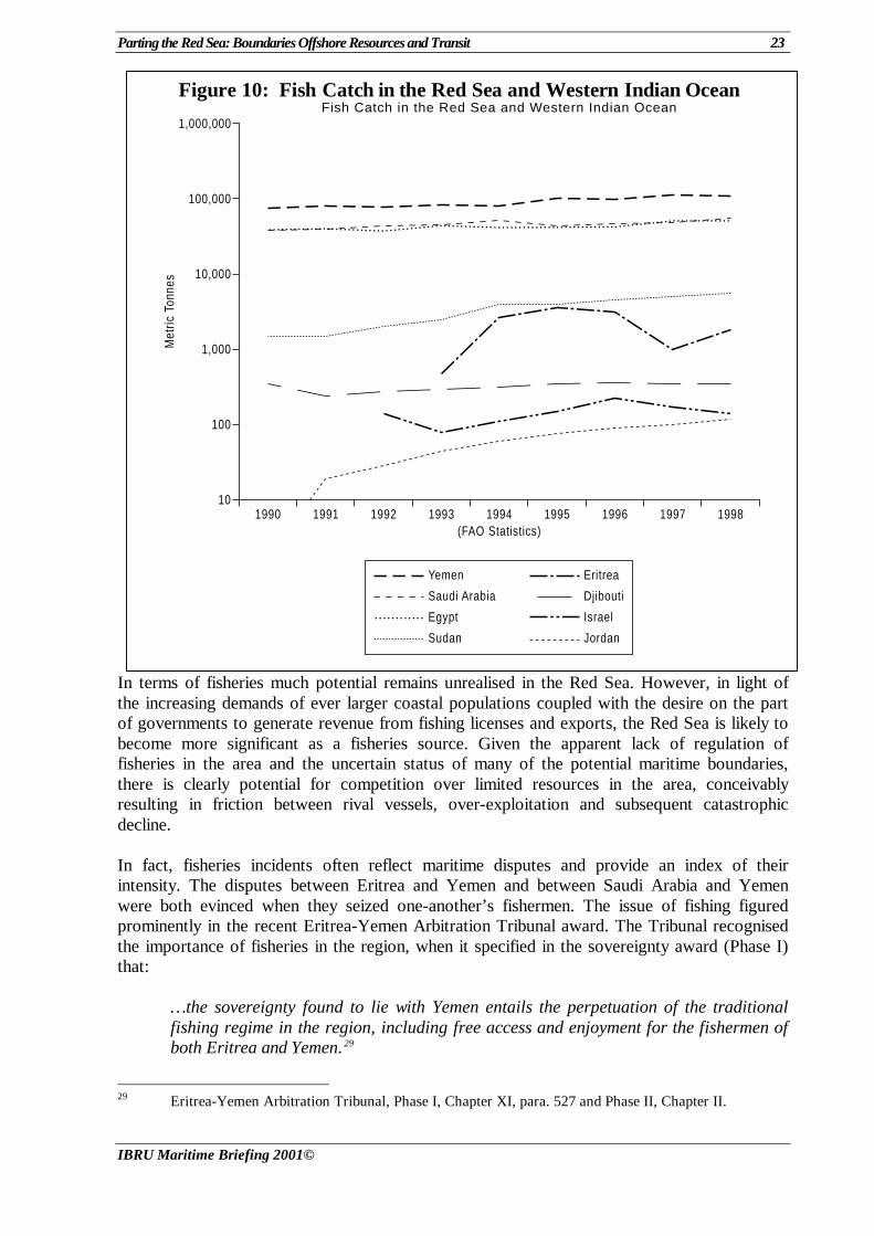
southwestern coast of the Gulf of Suez, was discovered in 1869 and entered production in 1910. More than 1,900 wells have been drilled in the Gulf of Suez basin. They define more than 120 fields. The first well drilled in the Egyptian Red Sea proper dates to 1916. Twenty-two dry holes, six with hydrocarbon shows, have been drilled there. Three dry holes were drilled along the central Sudanese coast in 1962, and ten attempts were made in the southern Tokar Delta between 1961 and 1996. An exploratory well was drilled in the disputed Halaib Triangle in 1982. Eritrea has an offshore, one-well gas field that has not yet produced. Eleven wells have tested the Dahlak Islands, between 1966 and 1977. Between 1967 and 1994, more than 30 wells were drilled along the Saudi coast. Seven shallow tests were drilled near oil seeps in the Farasan Islands in the 1930s. Thirteen wells were drilled in Yemen’s Red Sea Basin Province from 1961 to 1996. No wells have been sunk in the Gulf of Aqaba, which because of its age and depth is not prospective. The most promising areas seem to be in the Gulf of Suez and along the northern and southern margins of the Red Sea. Despite the complex geology and lack of massive finds, interest has remained. On 20 June 2000, Sudan announced that it was planning new concessions, including in the Red Sea zone.28 Exploration activities and the lease of blocks have been reason enough to enflame boundary disputes. For example, Saudi Arabia pushed BP to abandon its Yemeni concessions near their disputed offshore zone (see Section 5.2). Metalliferous Sediments As previously mentioned, a number of isolated deeps were discovered in the 1960s which contain metalliferous sediments with high concentrations of minerals such as copper, manganese, zinc, iron and silver. In the central Red Sea the deposits were large enough to encourage commercial exploitation by the German company Preussag AG on behalf of the joint Saudi-Sudanese Red Sea commission. However, it is understood that no exploration or exploitation of these resources is currently underway. 6.2 Living Resources Fisheries The Red Sea waters are highly productive fisheries, which are host to about 1,000 known species of fish. Fishery statistics for the Red Sea, proper, are not available, but the Food and Agriculture Organization (FAO) of the United Nations provides data for the western Indian Ocean, including the Red Sea and Persian Gulf. During the 1990s, the total catch for the eight coastal states has fluctuated between 160,000 and 223,000 metric tonnes. About half was caught by Yemen. More than 90% of the remaining marine catch was taken by Egypt and Saudi Arabia. (However, most of the fishery production of Egypt and Sudan derives from inland sources, in particular the Nile River.) The marine catches of Sudan and Jordan have climbed. Those of Eritrea and Israel have fluctuated markedly (see Figure 10, note that the vertical scale is logarithmic). The Red Sea fisheries are an important source of employment and nutrition for its coastal populations. Much of this fishing is subsistence or artisanal (FAO Fisheries Department).
28 Panafrican News Agency 20 June 2000.
Parting the Red Sea: Boundaries Offshore Resources and Transit 23
IBRU Maritime Briefing 2001©
Figure 10: Fish Catch in the Red Sea and Western Indian Ocean
1990 1991 1992 1993 1994 1995 1996 1997 199810
100
1,000
10,000
100,000
1,000,000
(FAO Statistics)
Met
ric T
onne
s
Eritrea
Djibouti
Israel
Jordan
Yemen
Saudi Arabia
Egypt
Sudan
Fish Catch in the Red Sea and Western Indian Ocean
In terms of fisheries much potential remains unrealised in the Red Sea. However, in light of the increasing demands of ever larger coastal populations coupled with the desire on the part of governments to generate revenue from fishing licenses and exports, the Red Sea is likely to become more significant as a fisheries source. Given the apparent lack of regulation of fisheries in the area and the uncertain status of many of the potential maritime boundaries, there is clearly potential for competition over limited resources in the area, conceivably resulting in friction between rival vessels, over-exploitation and subsequent catastrophic decline. In fact, fisheries incidents often reflect maritime disputes and provide an index of their intensity. The disputes between Eritrea and Yemen and between Saudi Arabia and Yemen were both evinced when they seized one-another’s fishermen. The issue of fishing figured prominently in the recent Eritrea-Yemen Arbitration Tribunal award. The Tribunal recognised the importance of fisheries in the region, when it specified in the sovereignty award (Phase I) that:
…the sovereignty found to lie with Yemen entails the perpetuation of the traditional fishing regime in the region, including free access and enjoyment for the fishermen of both Eritrea and Yemen.29
29 Eritrea-Yemen Arbitration Tribunal, Phase I, Chapter XI, para. 527 and Phase II, Chapter II.
24 Parting the Red Sea: Boundaries Offshore Resources and Transit
IBRU Maritime Briefing 2001©
Reefs Coral reefs are particularly abundant features in the Red Sea and represent an important resource for the coastal states. Reefs are essential for sustaining and renewing the area’s fisheries by acting as the breeding ground and nursery for fishstocks. Reefs also provide a host of other useful functions. They are a source of building materials and ornaments, provide natural coastal protection and can be used for the disposal of limited quantities of land-generated wastes. Perhaps most significantly, reef communities are a major genetic resource of scientific and educational value and may be of considerable value as a resource for tourism. While the southern Red Sea’s potential as a tourist destination for activities such as recreational diving has yet to be realised, the northern Red Sea’s diving resorts are renowned. Marine Fauna The Red Sea supports large numbers of marine animals, some of which are rare. These include: internationally significant populations of nesting Green and Hawksbill turtles; Dugongs; Giant Manta Rays, indigenous whale-sharks; dolphins and sharks. The Red Sea region is also host to several species of sea-birds such as White-eyed and Sooty gulls and White-cheeked, Saunders' and Lesser-crested terns as well as being an important migration route attracting rare breeds including Osprey and Sooty Falcons. In a similar way to coral reef communities, these rare species represent a major scientific and educational resource which could form the basis of tourism in the region. 7. Environmental Concerns “Although the Red Sea is still one of the World’s least ecologically damaged bodies of water, the number and scale of threats to its environment are growing, and current data on its status remain scarce” (UN Office for Project Services). Like other marine ecosystems that have extensive coral reefs, the Red Sea marine environment is fragile. Vessel traffic through the Suez Canal and from oil terminals along the Red Sea coast pose a serious threat to the marine environment, living resources, and tourism. A framework for addressing environmental issues in the Red Sea exists. The Regional Convention for the Conservation of the Red Sea and Gulf of Aden Environment was signed in Jeddah in 1982. It includes a protocol on combating oil pollution. An independent regional intergovernmental organisation, the Programme of Environment for the Red Sea and Gulf of Aden (PERSGA), was established to implement the Convention. Egypt, Jordan, the Palestinian Authority, Saudi Arabia, Somalia, Sudan, and Yemen participate in PERSGA, which is headquartered in Jeddah, Saudi Arabia. A Strategic Action Programme for the Red Sea and Gulf of Aden was adopted in 1982 and initiated in 1995. The aim of the program “is to develop a regional framework for protection of the environment and sustainable development of coastal and marine resources” (UN Office for Project Services; UNEP). Despite the existence of a legal framework for environmental cooperation among most of the Red Sea states, the political differences and animosity amid some of the countries probably precludes significant cooperation at the national level (UNEP, 1983).
Parting the Red Sea: Boundaries Offshore Resources and Transit 25
IBRU Maritime Briefing 2001©
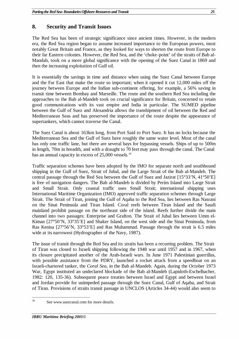
8. Security and Transit Issues The Red Sea has been of strategic significance since ancient times. However, in the modern era, the Red Sea region began to assume increased importance to the European powers, most notably Great Britain and France, as they looked for ways to shorten the route from Europe to their far Eastern colonies. However, the Red Sea, and the ‘choke-point’ of the straits of Bab al-Mandab, took on a more global significance with the opening of the Suez Canal in 1869 and then the increasing exploitation of Gulf oil. It is essentially the savings in time and distance when using the Suez Canal between Europe and the Far East that make the route so important; when it opened it cut 12,000 miles off the journey between Europe and the Indian sub-continent offering, for example, a 56% saving in transit time between Bombay and Marseille. The route and the southern Red Sea including the approaches to the Bab al-Mandeb took on crucial significance for Britain, concerned to retain good communications with its vast empire and India in particular. The SUMED pipeline between the Gulf of Suez and Alexandria allows the transhipment of oil between the Red and Mediterranean Seas and has preserved the importance of the route despite the appearance of supertankers, which cannot traverse the Canal. The Suez Canal is about 163km long, from Port Said to Port Suez. It has no locks because the Mediterranean Sea and the Gulf of Suez have roughly the same water level. Most of the canal has only one traffic lane, but there are several bays for bypassing vessels. Ships of up to 500m in length, 70m in breadth, and with a draught to 70 feet may pass through the canal. The Canal has an annual capacity in excess of 25,000 vessels.30 Traffic separation schemes have been adopted by the IMO for separate north and southbound shipping in the Gulf of Suez, Strait of Jubal, and the Large Strait of the Bab al-Mandeb. The central passage through the Red Sea between the Gulf of Suez and Jazirat [15°33’N, 41°50’E] is free of navigation dangers. The Bab al-Mandeb is divided by Perim Island into Large Strait and Small Strait. Only coastal traffic uses Small Strait; international shipping uses International Maritime Organization (IMO) approved traffic separation schemes through Large Strait. The Strait of Tiran, joining the Gulf of Aqaba to the Red Sea, lies between Ras Nasrani on the Sinai Peninsula and Tiran Island. Coral reefs between Tiran Island and the Saudi mainland prohibit passage on the northeast side of the island. Reefs further divide the main channel into two passages: Enterprise and Grafton. The Strait of Jubal lies between Umm el-Kiman [27°50’N, 33°35’E] and Shaker Island, on the west side and the Sinai Peninsula, from Ras Kenisa [27°56’N, 33°53’E] and Ras Muhammad. Passage through the strait is 6.5 miles wide at its narrowest (Hydrographer of the Navy, 1987). The issue of transit through the Red Sea and its straits has been a recurring problem. The Strait of Tiran was closed to Israeli shipping following the 1948 war until 1957 and in 1967, when its closure precipitated another of the Arab-Israeli wars. In June 1971 Palestinian guerrillas, with possible assistance from the PDRY, launched a rocket attack from a speedboat on an Israeli-chartered tanker, the Coral Sea, in the Bab al-Mandeb. Again, during the October 1973 War, Egypt instituted an undeclared blockade of the Bab al-Mandeb (Lapidoth-Eschelbacher, 1982: 120, 135-36). Subsequent peace treaties between Israel and Egypt and between Israel and Jordan provide for unimpeded passage through the Suez Canal, Gulf of Aqaba, and Strait of Tiran. Provisions of straits transit passage in UNCLOS (Articles 34-44) would also seem to
30 See www.suezcanal.com for more details.
26 Parting the Red Sea: Boundaries Offshore Resources and Transit
IBRU Maritime Briefing 2001©
safeguard access to the Red Sea and the Gulf of Aqaba. Therefore, the immediate issue of transit has receded from concern. However, there remain some unresolved issues. Declarations made by Yemen (YAR and PDRY), Sudan, Egypt, and Saudi Arabia upon signing or ratifying UNCLOS would all appear to restrict innocent or straits transit passage under certain conditions – most notably with regard to warships or nuclear-powered vessels. Djibouti also claims to restrict the innocent passage of nuclear-powered ships. Finally, Egypt’s straight baseline system has the effect of enclosing the Gulf of Suez as internal waters. This should result in a regime of innocent passage to the Suez Canal. The US Department of State has criticised the Egyptian straight baseline system and characterised the enclosure of the Gulf of Suez as “antithethical” to the provisions of the 1888 Constantinople Convention (US Department of State, 1994; Roach and Smith, 1996: 17, 183 and 219-21). 9. Conclusions The Red Sea divides Asia from Africa; it also divides its coastal states. Sovereignty and boundary disputes, overlapping jurisdictional claims, and squabbles over resources reinforce one another and make the sea a focus of conflict, rather than cooperation. None of these issues, in themselves, is particularly difficult to resolve if the countries have the political will. However, the will to compromise is the rarest of commodities in this region. Part IX of UNCLOS recognised the special status of semi-enclosed seas, such as the Red Sea, and called upon the littoral states to cooperate in the exercise of their rights and duties under the Law of the Sea. The proximity of the countries bordering the Red Sea makes this all too obvious to the casual observer. However, that cooperation is nascent, at best. The Israeli-Palestinian conflict poisons the atmosphere in the region and precludes negotiations between Israel and Egypt over their potential boundary in the northern Gulf of Aqaba. Presumably, it also inhibits resolution of the Egypt-Jordan boundary, which would begin at the Egypt-Jordan-Israel tripoint. Tensions with Israel have also excluded that country from participating in the Regional Convention for the Conservation of the Red Sea and the Gulf of Aden Environment and PERSGA. However, even among current members, there seems to be little effective cooperation in environmental matters. Other regional tensions and conflicts retard offshore delimitation. Egypt and Sudan do not appear to have made any significant progress in resolving the Halaib Triangle dispute or exploiting the resources off its coast. Tensions between Eritrea and Sudan preclude resolution of their boundary. Nor have Eritrea and Djibouti advanced in resolving their offshore boundary. The longest potential maritime boundary, that between Egypt and Saudi Arabia remains undelimited. The resources of the Red Sea, which could help feed and clothe the many needy in the neighbouring countries, are held hostage to the politics of confrontation. Overlapping claims and uncertain boundaries retards offshore oil and gas exploration. The Saudi-Sudanese Red Sea Commission appears moribund, with little progress in exploiting the metaliferous sediments. Overfishing is likely as long as the riparian countries do not cooperate.
Parting the Red Sea: Boundaries Offshore Resources and Transit 27
IBRU Maritime Briefing 2001©
Some of the Red Sea coastal states are bringing their maritime claims into conformity with UNCLOS, but much remains to be done, especially with regard to straight baseline claims. Transit issues, in particular with regard to Israeli access, seem to be resolved. However, the regimes of innocent and straits passage need clearer recognition in national legislation of the coastal states. The Red Sea continues to be a political fault line between Israel and the Arab states and between Asia and Africa. Much more needs to be done before the Red Sea regains the tranquility and freedom of use that it apparently enjoyed 3,500 years ago.
28 Parting the Red Sea: Boundaries Offshore Resources and Transit
IBRU Maritime Briefing 2001©
Appendices
Diplomatic Protests, Decrees and Legislation
Djibouti Maritime Jurisdiction (1978), in Lapidoth-Eschelbacher (1982). Decree establishing straight baselines around the Seba Islands, No. 85-048 (1985), in Limits in
the Seas, No. 113; in Law of the Sea Bulletin, No. 39.
Egypt Arrêté of the Egyptian Ministry of the Interior Relating to the Regions of the Nombas of Egypt
and the Sudan, and Which Comprise the Tribes of Becharia and of Malikab North in the Sudan, and the Tribes of Abadia in Egypt, dated 4 November, 1902, in Brownlie, 1979: 115-16.
Royal Decree Concerning the Territorial Waters of the Kingdom of Egypt, in Limits in the
Seas, No. 22 and Lapidoth-Eschelbacher, 1982. Decree Concerning the Continental Shelf (1958), in Lapidoth-Eschelbacher (1982). Declaration upon Ratification of the UN Convention on the Law of the Sea (26 Aug 1983), in
Law of the Sea Bulletin, No. 25 (June 1994). Baselines: Decree of the President of the Arab Republic of Egypt, No. 27 (1990), Concerning
the Baselines of the Maritime Areas of the Arab Republic of Egypt, 9 January 1990, in Law of the Sea Bulletin, No. 16; Limits in the Seas, No. 116.
Ethiopia Maritime Proclamation No. 137 (1953), in Lapidoth-Eschelbacher, 1982. Objection to the Declaration by the Yemen Arab Republic (8 Nov 1986), in Law of the Sea
Bulletin, No. 25.
Israel Submarine Areas and Territorial Waters Law (1953 and 1956), in Lapidoth-Eschelbacher,
1982. Territorial Waters (Amendment) Law, 5750-1990 of 5 February 1990, in Law of the Sea
Bulletin, No. 16. Objection to the Declaration by Egypt (11 Dec 1984), in Law of the Sea Bulletin, No. 25.
Parting the Red Sea: Boundaries Offshore Resources and Transit 29
IBRU Maritime Briefing 2001©
Jordan Fisheries Act No. 25 (1943), in Lapidoth-Eschelbacher, 1982.
Saudi Arabia Declaration Made upon Ratification of the United Nations Convention on the Law of the Sea,
in Law of the Sea Bulletin, No. 31. Decree (Straight Baselines and Territorial Sea) No. 1706 (1958), in Limits in the Seas, No. 20. Territorial Waters, Continental Shelf, and Exclusive Fisheries Zones (1958, 1968, 1974) in
Lapidoth-Eschelbacher, 1982; 1974 in Hakim, 1979: 204 Saudi Royal Decree Relating to the Acquisition of the Red Sea Resources No. M/27 (1968), in
Organisation of Petroleum Exporting Countries, Selected Documents of the International Petroleum Industry, 1968, Vienna, 1969: 33-34; ILM 8, 1969: 606.
Sudan Territorial Waters and Continental Shelf Act (1970), in Lapidoth-Eschelbacher, 1982; UN
Doc. ST/LEG/SER. B/16 (1974). Declaration upon Signature of the 1982 UN Convention, in Law of the Sea Bulletin, No. 25.
Yemen Decrees Concerning the Territorial Waters and Continental Shelf (YAR, 1967), in Lapidoth-
Eschelbacher, 1982; Hakim, 1979: 205-07. The Territorial Sea, Exclusive Economic Zone, Continental Shelf, and Other Marine Areas
(DY, 1977), in Lapidoth-Eschelbacher, 1982. Communiqué on the Red Sea (DY, 1978), in Lapidoth-Eschelbacher, 1982. Declaration of the Yemen Arab Republic upon Signature of the 1982 UN Convention, in Law
of the Sea Bulletin, No. 25. Declaration of the People’s Democratic Republic of Yemen upon Ratification of the 1982 UN
Convention on the Law of the Sea, 21 July 1987, in United Nations, 1989: 90. Merging of the People’s Democratic Republic of Yemen and the Yemen Arab Republic to
form a single State named Yemen, 22 May 1990, Letter dated 19 May 1990 from the Ministers for Foreign Affairs of the Yemen Arab Republic and The People’s Democratic Republic of Yemen to the Secretary-General of the United Nations, in Law of the Sea Bulletin, No. 16.
Protest Against the Publication by the Eritrean Government of a Map Showing Oil
Exploitation Zones in the Red Sea That Include Areas Subject to Yemeni Sovereignty (A/51/260, annex), in Law of the Sea Bulletin, No. 32.
30 Parting the Red Sea: Boundaries Offshore Resources and Transit
IBRU Maritime Briefing 2001©
Bilateral Agreement between Sudan and Saudi Arabia Relating to the Joint Exploitation of the Natural
Resources of the Sea Bed and Subsoil of the Red Sea in the Common Zone (1974), in Farid, 1984: 163-68; ST/LEG/Ser.B/18, 1978: 452.
Agreement on Principles of a Peaceful Settlement of the Dispute Between Eritrea and Yemen,
Paris, 21 May 1996 (S/1996/47, annex), in Law of the Sea Bulletin, No. 32. Maritime Boundary Agreement Between the Government of the State of Israel and the
Government of the Hashemite Kingdom of Jordan, 18 January 1996, in Law of the Sea Bulletin, No. 32. also in Report No. 8-12, Charney and Alexander, 1996.
Treaty of Peace between Egypt and Israel (1979), Article V.1 Treaty of Peace between Jordan and Israel. Joint Communiqué between the Republic of Sudan and the Arab Republic of Egypt, 22
December 1999, from the Sudanese Foreign Ministry website (http://sudmer.com/jointEgySud.htm).
International Boundary Treaty Between the Republic of Yemen and the Kingdom of Saudi
Arabia, 12 June 2000, in Boundary and Security Bulletin, 8, 2 (Summer 2000): 63-67. Note: The description of the maritime boundary in this version is incorrect as suggested in the footnote. See above.
Multilateral Constantinople Convention Respecting the Free Navigation of the Suez Maritime Canal
(1888), in Lapidoth-Eschelbacher, 1982: 192-94. Regional Convention for the Conservation of the Marine Environment of the Red Sea and the
Gulf of Aden Environment (Jeddah, 1982), entered into force in 1985. Protocol (to the Regional Convention for the Conservation of the Marine Environment of the
Red Sea and the Gulf of Aden Environment) concerning Regional Cooperation in Combating Pollution by Oil and Other Harmful Substances in Cases of Emergency (Jeddah, 1983), entered into force in 1985.
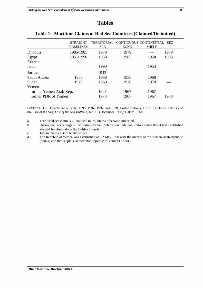
Parting the Red Sea: Boundaries Offshore Resources and Transit 31
IBRU Maritime Briefing 2001©
Tables
Table 1: Maritime Claims of Red Sea Countries (Claimed/Delimited)
STRAIGHT TERRITORIALa
CONTIGUOUS CONTINENTAL EEZ BASELINES SEA ZONE SHELF
Djibouti 1985/1985 1979 1979 — 1979 Egypt 1951/1990 1958 1983 1958 1983 Eritrea b — — — — Israel — 1990 — 1953 —
Jordan — 1943c
— — — Saudi Arabia 1958 1958 1958 1968 Sudan 1970 1960 1970 1970 — Yemend former Yemen Arab Rep. 1967 1967 1967 — former PDR of Yemen 1970 1967 1967 1978
SOURCES: US Department of State, 1995, 1994, 1992 and 1970; United Nations, Office for Ocean Affairs and the Law of the Sea, Law of the Sea Bulletin, No. 16 (December 1990); Hakim, 1979.
a. Territorial sea claim is 12 nautical miles, unless otherwise indicated. b. During the proceedings of the Eritrea-Yemen Arbitration Tribunal, Eritrea stated that it had established
straight baselines along the Dahlak Islands. c. Jordan claims a 3nm territorial sea. d. The Republic of Yemen was established on 22 May 1990 with the merger of the Yemen Arab Republic
(Sanaa) and the People’s Democratic Republic of Yemen (Aden).
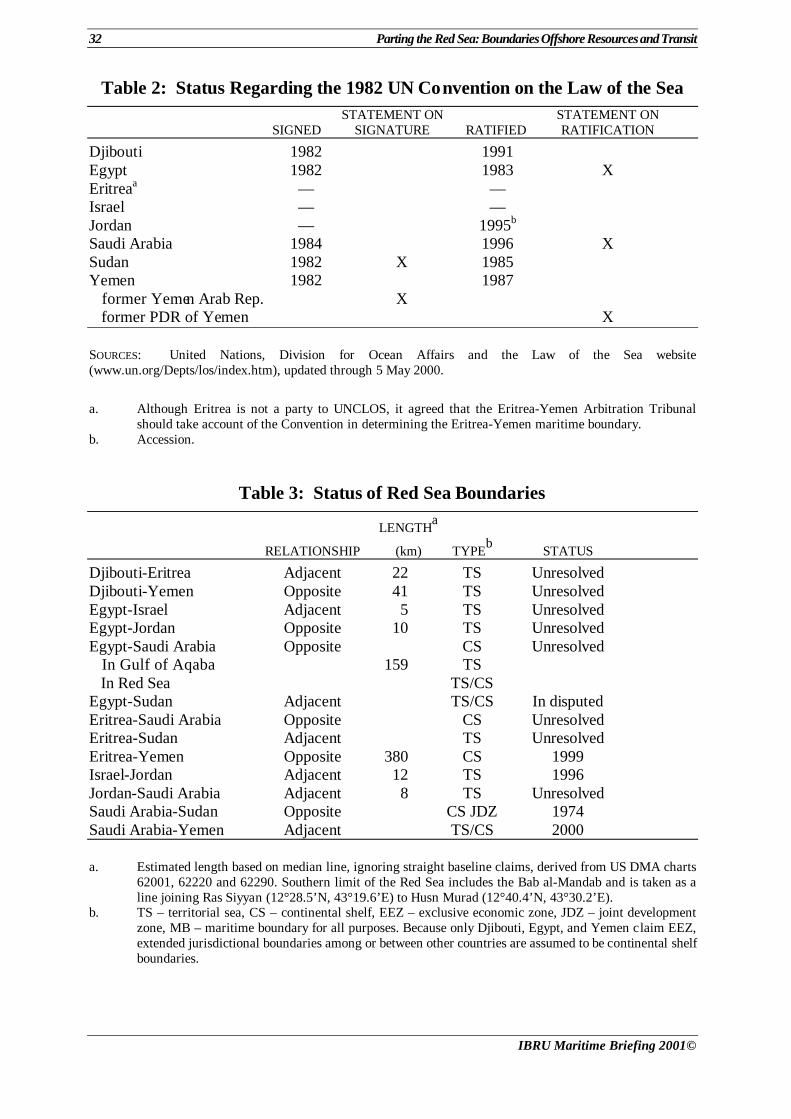
32 Parting the Red Sea: Boundaries Offshore Resources and Transit
IBRU Maritime Briefing 2001©
Table 2: Status Regarding the 1982 UN Convention on the Law of the Sea STATEMENT ON STATEMENT ON SIGNED SIGNATURE RATIFIED RATIFICATION
Djibouti 1982 1991 Egypt 1982 1983 X Eritreaa — — Israel — — Jordan — 1995b Saudi Arabia 1984 1996 X Sudan 1982 X 1985 Yemen 1982 1987 former Yemen Arab Rep. X former PDR of Yemen X SOURCES: United Nations, Division for Ocean Affairs and the Law of the Sea website (www.un.org/Depts/los/index.htm), updated through 5 May 2000.
a. Although Eritrea is not a party to UNCLOS, it agreed that the Eritrea-Yemen Arbitration Tribunal should take account of the Convention in determining the Eritrea-Yemen maritime boundary.
b. Accession.
Table 3: Status of Red Sea Boundaries
LENGTHa
RELATIONSHIP (km) TYPEb STATUS
Djibouti-Eritrea Adjacent 22 TS Unresolved Djibouti-Yemen Opposite 41 TS Unresolved Egypt-Israel Adjacent 5 TS Unresolved Egypt-Jordan Opposite 10 TS Unresolved Egypt-Saudi Arabia Opposite CS Unresolved In Gulf of Aqaba 159 TS In Red Sea TS/CS Egypt-Sudan Adjacent TS/CS In disputed Eritrea-Saudi Arabia Opposite CS Unresolved Eritrea-Sudan Adjacent TS Unresolved Eritrea-Yemen Opposite 380 CS 1999 Israel-Jordan Adjacent 12 TS 1996 Jordan-Saudi Arabia Adjacent 8 TS Unresolved Saudi Arabia-Sudan Opposite CS JDZ 1974 Saudi Arabia-Yemen Adjacent TS/CS 2000
a. Estimated length based on median line, ignoring straight baseline claims, derived from US DMA charts
62001, 62220 and 62290. Southern limit of the Red Sea includes the Bab al-Mandab and is taken as a line joining Ras Siyyan (12°28.5’N, 43°19.6’E) to Husn Murad (12°40.4’N, 43°30.2’E).
b. TS – territorial sea, CS – continental shelf, EEZ – exclusive economic zone, JDZ – joint development zone, MB – maritime boundary for all purposes. Because only Djibouti, Egypt, and Yemen claim EEZ, extended jurisdictional boundaries among or between other countries are assumed to be continental shelf boundaries.
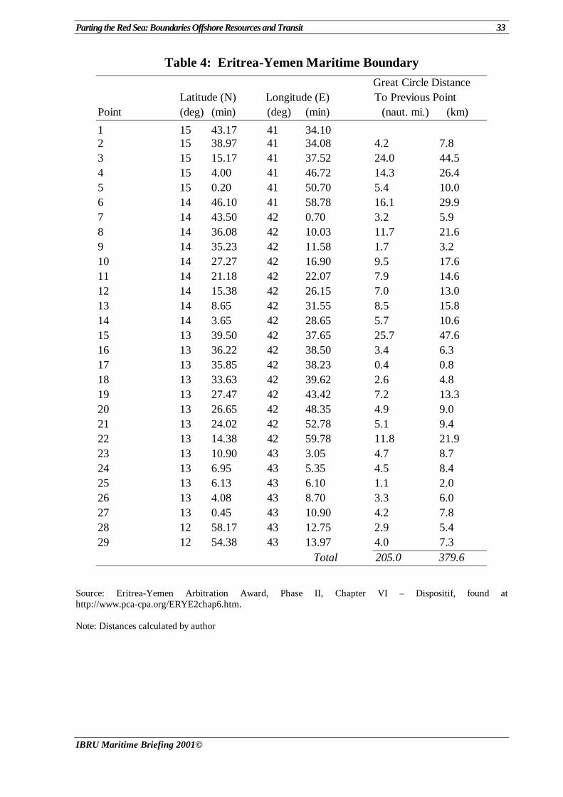
Parting the Red Sea: Boundaries Offshore Resources and Transit 33
IBRU Maritime Briefing 2001©
Table 4: Eritrea-Yemen Maritime Boundary
Great Circle Distance Latitude (N) Longitude (E) To Previous Point Point (deg) (min) (deg) (min) (naut. mi.) (km)
1 15 43.17 41 34.10 2 15 38.97 41 34.08 4.2 7.8 3 15 15.17 41 37.52 24.0 44.5 4 15 4.00 41 46.72 14.3 26.4 5 15 0.20 41 50.70 5.4 10.0 6 14 46.10 41 58.78 16.1 29.9 7 14 43.50 42 0.70 3.2 5.9 8 14 36.08 42 10.03 11.7 21.6 9 14 35.23 42 11.58 1.7 3.2 10 14 27.27 42 16.90 9.5 17.6 11 14 21.18 42 22.07 7.9 14.6 12 14 15.38 42 26.15 7.0 13.0 13 14 8.65 42 31.55 8.5 15.8 14 14 3.65 42 28.65 5.7 10.6 15 13 39.50 42 37.65 25.7 47.6 16 13 36.22 42 38.50 3.4 6.3 17 13 35.85 42 38.23 0.4 0.8 18 13 33.63 42 39.62 2.6 4.8 19 13 27.47 42 43.42 7.2 13.3 20 13 26.65 42 48.35 4.9 9.0 21 13 24.02 42 52.78 5.1 9.4 22 13 14.38 42 59.78 11.8 21.9 23 13 10.90 43 3.05 4.7 8.7 24 13 6.95 43 5.35 4.5 8.4 25 13 6.13 43 6.10 1.1 2.0 26 13 4.08 43 8.70 3.3 6.0 27 13 0.45 43 10.90 4.2 7.8 28 12 58.17 43 12.75 2.9 5.4 29 12 54.38 43 13.97 4.0 7.3 Total 205.0 379.6
Source: Eritrea-Yemen Arbitration Award, Phase II, Chapter VI – Dispositif, found at http://www.pca-cpa.org/ERYE2chap6.htm.
Note: Distances calculated by author
34 Parting the Red Sea: Boundaries Offshore Resources and Transit
IBRU Maritime Briefing 2001©
Bibliography
Abir, M. (1974) Oil, Power and Politics: Conflict in Arabia, the Red Sea, and the Gulf ,
London: Frank Cass. Aliboni, R. (1985) The Red Sea Region: Local Actors and the Superpowers, Syracuse, New
York: Syracuse University Press. Amann, H. (1985) ‘Development of Ocean Mining in the Red Sea’, Marine Mining, 5: 103-16. Banaja, A. A. (1990) Red Sea, Gulf of Aden and Suez Canal: A Bibliography on
Oceanographic and Marine Environmental Research, Jeddah: ALECSO-PERSGA; Paris: UNESCO.
Blissenbach, E. and Nawab, Z. (1983) ‘Metalliferous Sediments of the Seabed: The Atlantis-II
– Deep Deposits of the Red Sea’, Ocean Yearbook, 3: 77-104. British Broadcasting Corporation (BBC) Summary of World Broadcasts (SWB). Brownlie, I. (1979) African Boundaries: A Legal and Diplomatic Encyclopaedia, London: C.
Hurst. Charney, J.I. (1996) ‘Maritime Boundary Agreement between the Government of the State of
Israel and the Government of the Hashemite Kingdom of Jordan’, Report No. 8-12, in Charney and Alexander (eds) International Maritime Boundaries, The Hague: Kluwer Law International, CD-ROM.
Danseyar, A.E. (1982) ‘Legal Status of the Gulf of Aqaba and the Strait of Tiran: From
Customary International law to the Egyptian-Israeli Peace Treaty’, Boston College International and Comparative Law Review, 5: 127-74.
Degens, E.T. and Ross, D.A. (1969) (eds) Hot Brines and Recent Heavy Metal Deposits in the
Red Sea: A Geochemical and Geophysical Account, New York, NY: Springer-Verlag. Ding, H. and Koenig, E.S. (1989) ‘Treaty of Peace Between Egypt and Israel – Demarcation
of Internationally Recognized Boundaries...’, American Journal of International Law, 83: 590-95.
Directorate General of Mineral Resources (1977) Red Sea Research, 1970-1975, Jiddah:
Directorate General of Mineral Resources. Drysdale, A. (1987) ‘Political Conflict and Jordanian Access to the Sea’, Geographical
Review, 77: 86-102. Dzurek, D. J. (1996a) ‘Eritrea-Yemen Dispute Over the Hanish Islands’, Boundary and
Security Bulletin 4, 1 (Spring): 70-77.
(1996b) ‘The Hanish Islands Dispute’, Eritrean Studies Review, 1 (Fall): 134-52.
Parting the Red Sea: Boundaries Offshore Resources and Transit 35
IBRU Maritime Briefing 2001©
Edwards, A.J. and Head, S.M. (1987) Red Sea, Oxford: International Union for the Conservation of Nature and Natural Resources/Pergamon Press.
Egypt-Israel (1949) ‘Israel-Egypt: General Armistice Agreement (with annexes and
accompanying letters)’, signed at Rhodes on 24 February 1949, United Nations Treaty Series, No. 654, 43: 251-87.
El Mor, A. (1981) ‘The Regime of Passage in Straits Used for International Navigation in the
Light of the 3rd UN Conference on the Law of the Sea’, Revue égyptienne de droit international, 37: 13-83.
Elgarafi, A. (1980) ‘Metalliferous Muds in the Red Sea: A Review of Their Discovery ,
Exploration and Development’, Natural Resources Forum, 4: 324-27. Eritrea-Yemen Arbitration Tribunal, Eritrea-Yemen Arbitration Documents, Permanent Court
of Arbitration (Hague), website: http://www.pca-cpa.org/ER-YEMain.htm Farid, A.M. (1984) (ed.) The Red Sea: Prospects for Stability, London: Croom Helm; New
York: St. Martin’s Press. Fielden, D. G. (1978) The Political Geography of the Red Sea Region, Department of
Geography Occasional Publication No. 13, Durham, UK: University of Durham. Food and Agriculture Organization of the United Nations (FAO), FAO Fisheries Department
website (http://www.fao.org/fi/statist/). Foreign Broadcast Information Service (FBIS), US Department of Commerce, Daily Report:
Near East and South Asia (NES), available by subscription through the National Technical Information Service, World News Service website (http://wnc.fedworld).
Francalanci, G. and Scovazzi, T. (1994) ‘The Old and New Egyptian Legislation on Straight
Baselines’, in Blake, G.H. (ed.) Maritime Boundaries, London: Routledge. Glassner, M.I. and Unger, M. (1974) ‘Israel’s Maritime Boundaries’, Ocean Development and
International Law, 1: 303-13. El-Hakim, A.A. (1979) The Middle Eastern States and the Law of the Sea. Syracuse, NY:
Syracuse University Press. Hydrographer of the Navy (1987) Red Sea and Gulf of Aden Pilot, 12th edition (revised 1987).
Taunton: Hydrographer of the Navy. International Institute for Strategic Studies (IISS) (1972) Conflicts in Africa, Adelphi Paper,
No.3. London: IISS. Israel-Jordan (1949) ‘Hashemite Jordan Kingdom-Israel: General Armistice Agreement’
signed at Rhodes on 3 April 1949, United Nations Treaty Series, No. 656, 42: 304-25. Joffe, G. (1996) ‘Arab Frontier Disputes: The Consequences for Arab Security’, Geopolitics
and International Boundaries, 1 (Autumn): 159-77.
36 Parting the Red Sea: Boundaries Offshore Resources and Transit
IBRU Maritime Briefing 2001©
Johnson, D.H.N. (1968) ‘Some Legal Problems of International Waterways with Particular Reference to the Straits of Tiran and the Suez Canal’, Modern Law Review’ 31: 153-64.
Koury, E.M. and Nakhleh, E.A. (1979) The Arabian Peninsula, Red Sea, and Gulf: Strategic
Considerations, Hyattsville, MD: Institute of Middle Eastern and North African Affairs.
Kwiatkowska, B. (2000) ‘The Eritrea/Yemen Arbitration: Landmark Progress in the
Acquisition of Territorial Sovereignty and Equitable Maritime Boundary Delimitation’, Boundary and Security Bulletin, 8, 1 (Spring): 66-86.
Lapidoth, R. (1978) ‘Passage through the Strait of Bab al-Mandeb’, Israel Law Review 13:
180-93. Lapidoth-Eschelbacher, R. (1982) The Red Sea and the Gulf of Aden, International Straits of
the World, Vol. 5, The Hague: Martinus Nijhoff.
(1983) ‘The Straits of Tiran, the Gulf of Aqaba, and the 1979 Treaty of Peace between Egypt and Israel’, American Journal of International Law, 77: 84-108.
Lindquist, S.J. (1998) The Red Sea Basin Province: Sudr-Nubia and Maqna Petroleum
Systems, US Geological Survey, Open -File Report 99-50-A. MacDonald, C.G. (1980) Iran, Saudi Arabia, and the Law of the Sea, Westport, CT:
Greenwood Press. Merani, P.T. and Sterling, J.L. (1971) Legal Considerations of the Israeli-Egyptian Dispute
Involving the Right of Innocent Passage through the Straits of Tiran’, Indian Journal of International Law, 11: 411-34.
Miyoshi, M. (1999) The Joint Development of Offshore Oil and Gas in Relation to Maritime
Boundary Delimitation, Maritime Briefing, Vol. 2, No. 5, Durham: International Boundaries Research Unit.
National Imagery and Mapping Agency (NIMA) (1998) Sailing Directions (Enroute): Red Sea
and the Persian Gulf, 8th ed., Bethesda, MD: NIMA. Panafrican News Agency (PANA). Prescott, J. R. V. (1985) The Maritime Political Boundaries of the World, London: Methuen. Roach, J.A. and Smith, R.W. (1994) Excessive Maritime Claims, International Law Studies
Vol.66, Newport, RI: US Naval War College. Roberts, J. (2000) ‘The Saudi-Yemeni Boundary Treaty’, Boundary and Security Bulletin, 8, 2
(Summer): 70-73.
Parting the Red Sea: Boundaries Offshore Resources and Transit 37
IBRU Maritime Briefing 2001©
Schroeder, J.H. (1982) Aspects of Coastal Zone Management at the Sudanese Red Sea: Characteristics and Resources, Pollution, Conservation and Research, Khartoum: Institute of Environmental Studies, University of Khartoum.
Schofield, R.N. (1996) ‘The Last Missing Fence in the Desert: The Saudi-Yemeni Boundary’,
Geopolitics and International Boundaries, 1 (Winter): 247-99. Sintsove, T. A. (1988) ‘The Regime of Navigation in the Suez Canal’, Marine Policy, 12: 263-
70. United Nations, Division for Ocean Affairs and the Law of the Sea website
(www.un.org/Depts/los). United Nations Environment Programme (UNEP) website (www.UNEP.org). UNEP (1983) Regional Convention for the Conservation of the Red Sea and Gulf of Aden
Environment; Protocol Concerning Regional Co-operation in Combating Pollution by Oil and Other Harmful Substances in Cases of Emergency , New York, NY: United Nations.
United Nations Office for Project Services (UNOPS) website
(www.unops.org/5proin/5pi2012.html). United Nations (1983) The Law of the Sea: United Nations Convention on the Law of the Sea.
New York: United Nations. United Nations, Office for Ocean Affairs and the Law of the Sea (1989) The Law of the Sea:
Current Developments in State Practice No. II , New York: United Nations. US Department of State, Office of Ocean Affairs (1995) National Claims to Maritime
Jurisdictions, Limits in the Seas No. 36, 7th revision (11 January), Washington, DC: US Department of State.
(1994) Straight Baselines: Albania and Egypt, Limits in the Seas, No. 116, Washington,
DC: US Department of State.
(1992) Straight Baselines: Djibouti and Oman, Limits in the Seas, No. 113, Washington, DC: US Department of State.
(1970a) Straight Baselines: Saudi Arabia, Limits in the Seas, No. 20, Washington, DC: US
Department of State.
(1970b) Straight Baselines: United Arab Republic, Limits in the Seas, No. 22, Washington, DC.
US Department of State, Office of the Geographer (1962) Sudan-United Arab Republic
(Egypt) Boundary, International Boundary Study No. 18, Washington, DC: US Department of State.